Agenda
Notice is hereby given that an Ordinary Meeting of
Council will be held at the Civic Centre, Dee Why on
Tuesday 28 February 2023
Beginning at 6:00pm for the purpose of considering and
determining matters included in this agenda.

Ray Brownlee
PSM
Chief Executive Officer
V2
OUR VISION
Delivering the
highest quality service valued and trusted by our community
OUR VALUES
Trust Teamwork
Respect Integrity Service Leadership
OUR OBLIGATIONS
I swear/solemnly
and sincerely declare and affirm that I will undertake the duties of the office
of councillor in the best interests of the people of the Northern Beaches and
the Northern Beaches Council and that I will faithfully and impartially carry out
the functions, powers, authorities and discretions vested in me under the Local
Government Act 1993 or any other Act to the best of my ability and judgement.
1.0 ACKNOWLEDGEMENT
OF COUNTRY
2.0 Apologies and applications for leave of
absence and remote attendance
3.0 Confirmation of Minutes of Previous Meetings
3.1 Minutes of
Ordinary Council Meeting held 13 December 2022................................... 4
3.2 Minutes of
Extraordinary Council Meeting held 24 January 2023............................... 4
4.0 disclosures of interest
5.0 Public Forum AND PUBLIC ADDRESS
6.0 Items Resolved by Exception
7.0 Mayoral Minutes
Nil
8.0 Chief Executive Officer's Division Reports
Nil
9.0 Corporate and Legal Division Reports.................................................... 9
9.1 Use
of Delegated Authority by the Mayor over Christmas and New Year Recess 2022/23...................................................................................................................................... 9
9.2 Quarterly
Review - December 2022........................................................................... 10
9.3 Monthly
Investment Report - November 2022........................................................... 23
9.4 Monthly
Investment Report - December 2022........................................................... 35
9.5 Monthly
Investment Report - January 2023............................................................... 48
10.0 Community and Belonging Division Reports......................................... 61
10.1 Council
Representation to the Quarantine Station Community Consultative Committee.................................................................................................................................... 61
11.0 Environment and Sustainability Division
Reports
Nil
12.0 Planning and Place Division Reports....................................................... 64
12.1 Planning
Proposal 10-12 Boondah Road, Warriewood PEX2022/0001................... 64
12.2 Planning
Proposal for 6 Mitchell Road, Palm Beach - PEX2022/0003..................... 93
13.0 Transport and Assets Division Reports............................................... 114
13.1 Response
to Notice of Motion No 36/2022 - Potholes on Local Roads.................. 114
14.0 Workforce and Technology Division Reports
Nil
15.0 Notices of Motion............................................................................................ 117
15.1 Notice
of Motion No 1/2023 - Parking Restrictions Request, Pittwater Road, Collaroy 117
15.2 Notice
of Motion No 2/2023 - Beach Safety Signs................................................... 118
15.3 Notice
of Motion No 3/2023 - Cashless Gaming Card Reform................................ 121
15.4 Notice
of Motion No 6/2023 - Brewarrina Sister City Youth Program..................... 122
15.5 Notice
of Motion No 7/2023 - Urgent Request for a Safety Audit of Electric Bike,
Electric Scooter and Other Bike Usage on Northern Beaches Shared Paths, Bike
Paths and Footpaths.................................................................................................................. 123
15.6 Notice
of Motion No 8/2023 - Conservation Zones.................................................. 125
15.7 Notice
of Motion No 4/2023 - Duffys Forest Community Bridle Trail....................... 129
15.8 Notice
of Motion No 5/2023 - Daydream Street, Warriewood................................. 132
16.0 Questions with Notice................................................................................... 133
16.1 Question
With Notice No 1/2023 - Footpath, Seaview Road, Mona Vale............... 133
16.2 Question
With Notice No 2/2023 - GIPA Applications............................................. 134
16.3 Question
With Notice No 4/2023 - Dog Access at Cabbage Tree Bay Aquatic Reserve at the
Bower in Manly................................................................................................... 135
17.0 Responses to Questions With Notice..................................................... 136
17.1 Response
to Question With Notice No 22/2022 - Development Application Outcomes for
Former Pittwater Local Government Area............................................................... 136
17.2 Response
to Question With Notice No 23/2022 - Grandview Drive, Seaview Avenue, Newport -
Traffic Changes....................................................................................... 137
17.3 Response
to Question Taken on Notice No 2/2023 - SEPP Background............... 139
17.4 Response
to Question With Notice No 3/2023 - NSW Ombudsman Report - 2021-22
Northern Beaches Council Complaints Breakdown................................................. 141
18.0 matters proposed to take place in closed
session...................... 143
18.1 Exemption
from Tendering for Provision of Groceries for Children's Services, Glen Street
Theatre and the NSW Rural Fire Service
18.2 RFT
2022/109 - Software Provider for Children's Services Tender Outcome
18.3 RFT
2022/224 - Manly Dam Link Trail Boardwalk
18.4 RFT
2022/100 - Irrigation Maintenance Services
18.5 Response
to Notice of Motion No 38/2022 - Soft Plastics Recycling
18.6 Minutes
of the Property Steering Committee Meeting held on 28 July 2022 and 21
September 2022.
18.7 Facilitating
a Group Power Purchase Agreement for Northern Beaches Businesses
19.0 Report of Resolutions Passed in Closed Session
|

|
Ordinary Council Meeting
|
|
28 February 2023
|
1.0 ACKNOWLEDGEMENT OF COUNTRY
|
As a sign of
respect, Northern Beaches Council acknowledges the traditional custodians of
these lands on which we gather and pays respect to Elders past and present.
|
2.0 Apologies AND applications for leave of
absence AND REMOTE ATTENDANCE
|
In accordance
with Part 6 of the Code of Meeting Practice, Council will consider apologies,
requests for leave of absence, and requests to attend meetings remotely via
audio-visual link.
|
3.0 Confirmation
of minutes
3.1 Minutes
of Ordinary Council Meeting held 13 December 2022
|
Recommendation
That the minutes of the Ordinary Council
Meeting held 13 December 2022, copies of which were previously circulated, be
confirmed as a true and correct record of the proceedings of that meeting.
|
3.2 Minutes
of Extraordinary Council Meeting held 24 January 2023
|
Recommendation
That the minutes of the Extraordinary
Council Meeting held 24 January 2023, copies of which were previously
circulated, be confirmed as a true and correct record of the proceedings of
that meeting.
|
4.0 disclosures of interest
|
In accordance
with Part 17 of the Code of Meeting Practice, all Councillors must disclose
and manage any conflicts of interest they may have in matters being
considered at the meeting.
A Councillor who
has a pecuniary interest in any matter with which Council is
concerned, and who is present at a meeting of Council at which the matter is
being considered, must disclose the nature of the interest to the meeting as
soon as practicable.
The Councillor
must not be present at, or in sight of, the meeting:
a.
at any time during which the matter is being considered or discussed,
or
b.
at any time during which Council is voting on any question in relation
to the matter.
A Councillor who
has a significant non-pecuniary conflict of interest in a matter under
consideration at a Council meeting, must manage the conflict of interest as
if they had a pecuniary interest in the matter.
A Councillor who
determines that they have a non-pecuniary conflict of interest in a matter
that is not significant and does not require further action, when
disclosing the interest must also explain why the conflict is not significant
and does not require further action in the circumstances.
As required by
Council’s Code of Conduct and the Information and Privacy
Commission’s Information Access Guideline 1, returns made by designated
persons are routinely tabled at Council meetings and published on
Council’s website.
|
5.0 Public Forum AND PUBLIC ADDRESS
|
In accordance
with Part 5 of the Code of Meeting Practice, residents, ratepayers,
applicants or other persons may request to address Council in relation to any
one matter related to the general business of Council but not the subject of
a report on the agenda (Public Forum) and no more than two matters listed for
consideration on the agenda (Public Address).
|
6.0 Items Resolved by EXCEPTION
|
In accordance
with Part 14 of the Code of Meeting Practice, items that are dealt with by
exception are items where the recommendations contained in the staff reports
in the agenda are adopted without discussion.
|
|

|
Report To Ordinary Council MEETING
|
|
ITEM NO. 9.1 - 28 February 2023
|
9.0 Corporate and Legal
Division Reports
|
ITEM 9.1
|
Use
of Delegated Authority by the Mayor over Christmas and New Year Recess
2022/23
|
|
REPORTING
MANAGER
|
Executive
Manager Governance & Risk
|
|
TRIM
file REF
|
2022/677650
|
|
ATTACHMENTS
|
Nil
|
purpose
To inform Council how the delegated
authority granted to the Mayor by the Council over the 2022-23 recess was
exercised.
REPORT
In November 2022 Council granted authority to the Mayor to
make decisions on the governing body’s behalf on urgent
matters over the recess period 14 December 2022 to 31 January 2023 inclusive.
The resolution (351/22) required a report to be provided to the 28 February
2023 Council meeting outlining how the delegated authority
was exercised.
This report is to advise Council there were no decisions
made under the delegation of authority by the Mayor over the recess period.
LINK TO COUNCIL STRATEGY
This report relates to the Community
Strategic Plan Outcome of Good Governance Goal 19 - Our Council is transparent
and trusted to make decisions that reflect the values of the community.
FINANCIAL CONSIDERATIONS
There are no financial considerations in
relation to this report.
ENVIRONMENTAL CONSIDERATIONS
There are no environmental considerations
in relation to this report.
Social considerations
There are no social considerations in
relation to this report.
governance and risk
considerations
This report meets the requirements of
Council resolution 351/22 Council Delegated Authority - Christmas / New Year
Recess 2022-23.
RECOMMENDATION OF Director Corporate and Legal
That Council note the report.
|
|
Report To Ordinary Council MEETING
|
|
ITEM NO. 9.2 - 28 February 2023
|
|
ITEM 9.2
|
Quarterly
Review - December 2022
|
|
REPORTING
MANAGER
|
Executive
Manager Strategy & Performance AND
EXECUTIVE MANAGER FINANCIAL PLANNING AND SYSTEMS
|
|
TRIM
file REF
|
2022/774756
|
|
ATTACHMENTS
|
1 ⇨Progress of the Operational Plan - December 2022
(Included In Attachments Booklet)
2 ⇨Quarterly Budget Review Statement - December 2022
(Included In Attachments Booklet)
3 ⇨Stronger Communities Funds and New Council
Implementation Fund - December 2022 (Included In Attachments Booklet)
|
purpose
To present financial and service performance results for the
period ended 31 December 2022, and a progress report on
the expenditure from the $36.1 million Stronger Communities Fund (SCF) provided by the New South Wales (NSW) Government.
executive summary
This
report details Council’s service performance results and the consolidated
financial position for the period ended 31 December 2022. The Quarterly Review
is a progress report on the implementation of the Operational Plan 2022/23.
The
operating result (which includes capital grants and contributions) for the
financial year is forecast to increase by $5.8 million to a surplus of $48.4
million. Excluding capital grants and contributions the result is forecast to
improve by $0.8 million, from a surplus of $6.6 million to a surplus of $7.4
million.
Capital
expenditure is forecast to increase by $2.1 million to $108.2 million,
primarily due a new $9.1 million Regional and Local Roads Repair Program grant,
of which $3.4 million will be spent this financial year.
Council’s
budget remains balanced. Investment returns remain strong following rising interest
rates, with an additional $0.8 million expected (which relates to Kimbriki and
restricted reserve funds). An additional $1.4 million from development
contributions is also anticipated.
Council’s
2022/23 Operational Plan contains 196 actions relating to both operational and
capital projects. Of the 196 actions the majority (86%) are progressing on
schedule, including 23 completed. The Plan also contains performance measures.
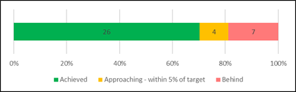
Of the 37 reportable measures, 81% have met or approached their targets this
quarter.
The Report also details expenditure
associated with the implementation of Council’s SCF projects supported by
NSW Government funds, including an update on the performance space being built
at Mona Vale Public School and construction of the new Long Reef Surf Life
Saving Club.
RECOMMENDATION OF Director Corporate and Legal
That Council:
1. Note the December 2022
Quarterly Budget Review Statement.
2. Approve the following changes
to the Current Forecast in the December 2022 Quarterly Budget Review Statement:
A. An
increase in the forecast surplus from Continuing Operations, which includes
Capital Grants and Contributions, of $5.786 million to $48.356 million.
B. An
increase in capital expenditure by $2.101 million to $108.175 million.
3. Note the Quarterly Report on
Service Performance for the period ended 31 December 2022.
4. Note
the Quarterly Report on expenditure of funds from the Stronger Communities Fund
for the period ended 31 December 2022.
BACKGROUND
Northern Beaches Council’s
Operational Plan 2022/23 was adopted on 28 June 2022. The Operational Plan is
for the period 1 July 2022 to 30 June 2023.
The Quarterly Budget Review Statement is a
regular progress report against the Operational Plan 2022/23. It has been
prepared in accordance with the requirements of the Local Government (General)
Regulation 2021 (Cl203) and essential element 4.9 of the Integrated Planning
and Reporting Guidelines (September 2021), namely that the Responsible
Accounting Officer report quarterly on a budget review statement and the Chief
Executive Officer report at least every six months on the principal activities.
The Quarterly Budget Review Statement
provides reporting to adequately disclose Council’s overall financial
position as well as provide sufficient information to enable informed decision
making while ensuring transparency.
The Quarterly Report on Service Performance
discloses the progress of key services in the delivery of projects and against
performance measures.
The report includes updates for the period
ending 31 December 2022:
· Service performance
· Financial performance and position, contracts listing and
recommended changes to the budget
· The outcomes delivered from the $36.1 million Stronger Communities
Fund (Attachment 3).
Overview of service performance
A report
on Council’s service performance is provided at Attachment 1. This is a comprehensive report on Council’s 196 operational and
capital projects, 37 reportable service performance measures, seven workload
measures and service highlights across our 16 key services.
Council is making good progress towards
achieving its performance targets and delivering operational and capital
projects. Most missed targets and half the delayed projects are due to external
factors including storm events, persistent wet weather, COVID and third-party
issues.
A summary of our
performance is outlined below.
|
Performance measures
Overall 81% of Council’s 37 performance measures met or approached the
target. Of the 11 measures that did not achieve their target, most were impacted by weather
events, third-party issues or reduced demand.
|
|
|
Operational
project progress
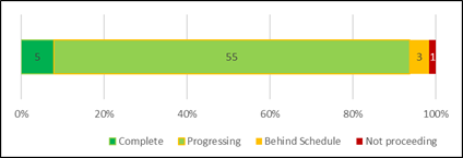
Of the 64
operational projects, 94% are progressing on schedule.
Of the
three projects behind schedule, two were affected by the response to storms
and persistent wet weather. One other project will not proceed as the need
has been fulfilled by other initiatives.
Target:
80% complete/on schedule as at 30 June 2023
|
Two operational projects
were completed this quarter:
· Review environmental compliance tools and
procedures to improve customer experience
· Currawong Cottages and surrounds - Refurbishment, Modernisation and
Environmental works
|
|
Capital project progress
Of the 132
capital projects, 82% are complete or progressing on schedule.
Of the 24
projects behind schedule, half are due to external factors such as storm
events, persistent wet weather, COVID or third party delays.
Target:
80% complete/on schedule as at 30 June 2023
|
13 capital
projects were completed this quarter:
· Ashley Parade Reserve - new playground
· Church Point Masterplan Boardwalk
extension
· Coast Walk Aboriginal art and signage
· Currawong Cottages
· Gallery Art Work Purchases
· Jacka Park playground upgrade
· Kimbriki landfill cell development area
4A
· Kimbriki landfill cell development
mid-west
· Library Bookstock
· Mona Vale Surf Life Saving Club
· Narrabeen Lagoon pedestrian and cycle
bridge
· North Curl Curl Youth Facility
· Sydney Lakeside Holiday Park renewal
|
Service Review Program
The Office of Local Government’s
Integrated Planning and Reporting Guidelines for Local Government in NSW places
requirements on Council in relation to service reviews. Essential Element 4.17
states that “…the Operational Plan must specify each review to be
undertaken in that year.” At the time of the development of the 2022/23
Operational Plan, Council had completed a holistic review of all its 57
services with a resulting program of actions to be undertaken. These actions
are being implemented based on available resources.
In August 2022, a workshop was held with
Councillors to look at the next step in the service review program. As a
result, reviews of the following services will be complete or in progress by
June 2023:
· Facilities Management and Services (Building Maintenance) - complete
· Street Sweeping – complete
· Roads and Transport Infrastructure (Road Maintenance) – in
progress
· Public and Environmental Health – in progress.
As the Service Review oversight committee,
Council’s Audit, Risk and Improvement Committee will be updated with the
progress of each Service Review. Any recommendations that significantly impact
service levels and require a decision of Council will be brought to Council for
consideration.
Stronger Communities Fund (SCF)
Attachment 3 outlines the progress of
projects funded by the NSW Government’s SCF. While four projects
are ongoing, a range have been completed such as accessible playgrounds,
cycleways, surf lifesaving clubs, netball courts and performance spaces.
Overview of Financial Performance
Responsible Accounting Officer Budget
Review Statement
The following statement is made in
accordance with Clause 203(2) of the Local Government (General) Regulations
2021:
“It is my opinion that
the Budget Review Statement for Northern Beaches Council for the period ending
31 December 2022 indicates that Council’s projected financial position at
30 June 2023 will be satisfactory, having regard to the projected estimates of
income and expenditure and the original budgeted income and expenditure.”
David Walsh Chief
Financial Officer, Northern Beaches Council.
Income Statement – progress and
forecast changes
The attached Quarterly Budget Review
Statement (QBRS) provides an overview of Council’s progress against the
annual budget at the end of the December 2022 quarter and provides explanations
for major variations that result in recommendations for budget changes.
Operating budget summary – as at 31 December 2022
($’ million)
For the six months to 31 December 2022 the
operating result (incl capital grants and contributions) is $5.5 million
favourably ahead of budget, primarily due to phasing of expenditure and income
items partially offset by the timing of the release of capital grant funding
against project expenditure milestones and costs associated with natural
disasters.
The operating surplus which includes capital grants and
contributions for the financial year is forecast to increase by $5.8 million to
$48.1 million. Income is forecast to increase by $7.2 million while operating
expenses will increase $1.5 million (primarily due to higher than expected
investment income offset by expenditure on storm events and capital grants and
contributions).
The operating result excluding capital grants and
contributions is forecast to improve by $0.8 million to a $7.4 million surplus.
These overall movements are summarised in the table below, under the
‘Recommended Changes’ column.
Operating budget as at 31 December 2022 – summary of
recommended changes
|
|
Annual
|
Year to date
|
|
$’000
|
ORIGINAL Budget
|
REVISED Budget
|
Recommended changes
|
CURRENT Forecast
|
Actual
|
Approved
Budget
|
Variance
|
|
Income
|
400,340
|
415,485
|
7,242
|
422,727
|
323,549
|
322,992
|
557
|
0%
|
|
Operating
expenses
|
(361,781)
|
(372,915)
|
(1,456)
|
(374,371)
|
(172,815)
|
(177,764)
|
4,949
|
3%
|
|
Surplus
/ (Deficit)
|
38,559
|
42,569
|
5,786
|
48,356
|
150,734
|
145,228
|
5,506
|
4%
|
|
Surplus
/ (Deficit) before Capital Grants
& Contributions
|
8,795
|
6,646
|
764
|
7,410
|
133,602
|
125,729
|
7,873
|
6%
|
Attachment 2 ‘Quarterly Budget Review
Statement - December 2022’ provides further information on the proposed
variations to the budget.
Income Year to Date (YTD) Analysis
Total income
at the end of December 2022 is $323.5 million which is $0.6 million above the
forecast. The principal reasons for this variance are as follows:
Income as at 31 December 2022 – Variance to Approved
YTD Budget
|
YTD Variance $’000
|
Details – Favourable / (Unfavourable)
|
|
184
|
Rates
and Annual Charges
|
|
|
|
|
1,004
|
User
Charges & Fees
|
|
|
· Stronger than anticipated income:
o Kimbriki Waste & Recycling Centre
$0.6m
o Sydney Lakeside $0.4m
· Lower income sources including:
o Restoration charges ($0.2m)
o Child Care ($0.2m)
· Timing of revenue recognition for
development assessments $0.5m
|
|
301
|
Investment
Fees and Revenues
· Stronger than anticipated income due to
higher interest rates and higher investment balances
|
|
(383)
|
Other
Revenue
· Stronger than anticipated income:
o Investment losses recovered $0.3m
o Kimbriki recycling income $0.1m
· Lower income sources including:
o Parking fines ($0.8m)
o Other fines ($0.1m)
· Timing of revenue recognition for
advertising on Council structures $0.2m
|
|
1,653
|
Grants
and Contributions – Operating Purposes
|
|
· Disaster grant funds received in advance
$1.9m
· Library Subsidy Grant received earlier
than anticipated $0.8m
· Timing of revenue recognition of grants
to match expenditure of funds including the B-Line offset tree planting
program from Mona Vale to Seaforth Road corridor ($0.8m) and Currawong works
($0.3m)
|
|
(2,367)
|
Grants
and Contributions – Capital Purposes
|
|
· Development contributions higher than
expected $2.9m
· Timing of revenue recognition of grants
to match expenditure of funds including:
o Queenscliff headland access ramp ($0.9m)
o Footpath renewal works ($0.8m)
o Traffic facility delivery program ($0.8m)
o Active Transport Corridor ($0.6m)
o Clontarf Reserve Tidal Pool ($0.6m)
o Streets as Shared Spaces (Avalon) ($0.4m)
· Delay in payment of the Duffys Forest
Rural Fire Station contribution ($0.7m) and Long Reef SLSC contribution
($0.4m)
|
|
(261)
|
Other
Income
|
|
|
· Property leases including Lakeside
Holiday Park ($0.2m)
|
|
426
|
Gain
on disposal of assets
|
|
|
· Timing of proceeds on sale of plant &
equipment
|
|
557
|
TOTAL
INCOME VARIANCE – YTD ACTUALS WITH YTD BUDGET
|
Operating
Expenses Year to Date (YTD) Analysis
Total operating expenses at the end of December 2022 is
$172.8 million, which is $4.9 million under the forecast. The principal reasons
for this variance are as follows:
Operating expenses as at 31 December 2022 – Variance
to Approved YTD Budget
|
YTD Variance
$’000
|
Details – Favourable / (Unfavourable)
|
|
979
|
Employee
Benefits and Oncosts
|
|
|
Lower primarily
due to vacancies in Corporate Support, Transport and Environmental Compliance
Services. This was partially offset by higher expenditure in Children’s
Services due to a higher utilisation of casual staff due to the
unavailability of agency staff and trainees.
|
|
44
|
Borrowing
Costs
|
|
|
|
|
5,325
|
Materials
and Services
|
|
|
· Timing of works:
o IT and communications $1.4m
o Bush regeneration $0.7m
o Tree works $0.6m (delays in B-Line grant
funded project)
o Land use planning $0.4m
o Environment and floodplain $0.5m (incl
grant funded projects)
o Recreation and sportsfields $0.4m (Cromer
High School Sportsfield)
o Staff training programs $0.3m
o Utilities $0.3m
· Lower than anticipated expenditure:
o Waste disposal costs $0.6m
o Legal services $0.4m
· Higher than anticipated expenditure:
o Storm related damage clean up ($0.3m)
o Kimbriki Waste and Recycling Centre
($0.2m)
|
|
(871)
|
Depreciation
and Amortisation
|
|
|
· Due to the timing of the completion and
capitalisation of new assets.
|
|
(529)
|
Other
Expenses
|
|
· Kimbriki Waste levy ($0.3m)
· Timing of Surf Lifesaving NSW subsidies
($0.1m)
· Delays in project milestones for Mona
Vale Performance Space ($0.1m)
|
|
4,949
|
TOTAL
OPERATING EXPENSES VARIANCE - YTD ACTUALS WITH YTD BUDGET
|
Capital Budget Statement
Capital
expenditure is forecast to increase by $2.1 million to $108.2 million,
primarily due to a new Regional and Local Roads Repair Program grant.
Proposed variations to the capital expenditure budget are
outlined in Attachment 2 ‘Quarterly Budget Review Statement - December
2022’ and include:
· Budget increases in the December 2022 quarterly review include:
o $3.4m Regional and Local roads repair program (grant)
o $1.3m New footpaths program (grant)
o $1.0m Active transport corridor project (grant)
o $0.8m Cromer Depot improvement plan works
· Budgets rephased to future years in the December 2022 quarterly
review include:
o ($2.4m) Active transport corridor project (grant)
Capital
Expenditure Year to Date (YTD) Analysis
Expenditure on capital works for
the six months ended 31 December 2022 is $34.8 million against a year-to-date
budget of $50 million.
Capital budget summary – as at 31 December 2022
($’million)
The principal reasons for the variance in
expenditure versus the year-to-date budget are as follows:
Capital expenditure as at
31 December 2022 – Variance to Approved YTD
Budget
|
YTD Variance $’000
|
Details – Favourable / (Unfavourable) YTD Variance
|
|
6,833
|
Capital
Expenditure – Renewal Projects
|
|
|
· Primarily due to the timing of works
including the road resheeting program $1.5m, footpath renewal programs $1.2m
and planned stormwater renewal works $0.7m.
|
|
8,459
|
Capital
Expenditure – New Projects
|
|
|
· Primarily due to the timing of works
including the new footpaths program $2.2m, Queenscliff headland access ramp
$0.9m and traffic facility works $0.8m.
|
|
15,292
|
TOTAL CAPITAL EXPENDITURE VARIANCE – YTD
ACTUALS WITH YTD BUDGET
|
Further information on the progress of
capital projects is available within Attachment 1 ‘Quarterly Report on
Service Performance’.
Cash and
Investments
The balance of cash and investments as at
31 December 2022 was $193 million. The revised projected balance on 30 June
2023 is $145 million, $46 million higher than the Original Budget forecast of
$99 million, primarily due to rephasing of capital expenditure to the 2023-2024
financial year and new grants and contributions.
Cash and investments – as at 31 December 2022
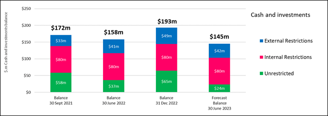
Further
information is available on cash and investments within Attachment 2
‘Quarterly Budget Review Statement - December 2022’ to this report.
Financial
Performance Measures
The following financial performance
measures indicate that Council will meet the Office of Local Government’s
benchmarks.
|
|
|
Forecast result
|
Forecast indicator
|
|
Benchmark
|
|
$ '000
|
|
30/6/2023
|
30/6/2023
|
|
|
|
1. Operating Performance
|
|
|
|
|
|
|
Total continuing operating revenue1 excluding capital
grants and contributions less operating expenses
|
|
7,023
|
1.84%
|
✔
|
>0%
|
|
Total continuing operating revenue1 excluding capital
grants and contributions
|
|
381,312
|
|
1. Excludes fair value adjustments,
reversal of revaluation decrements and net gain on sale of assets.
This
ratio measures Council’s achievement of containing operating
expenditure within operating revenue. It is important to distinguish that
this ratio is focusing on operating performance and hence capital grants and
contributions, fair value adjustments, net gain on sale of assets and
reversal of revaluation decrements are excluded.
For the 2022/23 financial year, the
forecast result remains above the benchmark.
|
|
|
|
Forecast result
|
Forecast indicator
|
|
Benchmark
|
|
$ '000
|
|
30/6/2023
|
30/6/2023
|
|
|
|
2. Unrestricted Current Ratio
|
|
|
|
|
|
|
Current assets less all external restrictions
|
|
124,792
|
1.69x
|
✔
|
>1.5x
|
|
Current liabilities less specific purpose liabilities
|
|
73,697
|
|
The
Unrestricted Current Ratio is specific to local government and is designed to
represent a Council’s ability to meet short term obligations as they
fall due. Restrictions placed on various funding sources (e.g., development
contributions and domestic waste income) complicate the traditional current
ratio used to assess liquidity of businesses as cash allocated to specific
projects is restricted and cannot be used to meet a Council’s other
operating and borrowing costs – these funding sources are removed from
this ratio.
For the 2022/23 financial year, the
forecast result will continue to meet the benchmark.
|
CONSULTATION
Where relevant, community feedback on activities or events
is included in the attachment.
TIMING
The Quarterly Budget Review Statement meets the requirements
of the Local Government Act 1993 (s404(5)) and Local Government (General)
Regulation 2021 (S203), namely that Council report quarterly on a budget review
statement, and at least every six months on the principal activities of its
Operational Plan.
LINK TO STRATEGY
This report relates to the Community
Strategic Plan Outcome of:
· Good governance - Goal 19 Our Council is transparent and trusted to
make decisions that reflect the values of the community
financial considerations
The operating surplus (which includes capital grants and
contributions) for the financial year is forecast to increase by $5.8 million
to a surplus of $48.4 million. Excluding capital grants and contributions the
result is forecast to improve by $0.8 million, from a surplus of $6.6 million
to a surplus of $7.4 million. Capital Expenditure is forecast to increase by
$2.1 million to $108.2 million.
Council’s
budget remains balanced and is expected to meet all financial performance
benchmarks this financial year.
social considerations
The report discloses progress on implementing the
Operational Plan 2022/23. This includes the continued
delivery of services and capital works that support our community and economy.
These initiatives will have a positive social and economic impact on the
community, including additional services and support available during natural
hazard events and the COVID-19 pandemic.
environmental considerations
The report provides progress on
implementing the Operational Plan 2022/23 which includes a range of projects to
protect and enhance our natural environment - by managing our coast, bush and
biodiversity; implementing catchment management initiatives; and a variety of
on-ground works and education in our urban and natural settings.
governance and risk
considerations
The Quarterly Budget Review Statement meets
the statutory reporting requirements for progress at the end of the quarter
– i.e., implementation of the Operational Plan 2022/23 and
Council’s overall financial position. It is provided to enable informed
decision making while also ensuring transparency on Council’s governance,
business assurance and financial sustainability.
|

|
Report To Ordinary Council MEETING
|
|
ITEM NO. 9.3 - 28 February 2023
|
pp
|
ITEM 9.3
|
Monthly
Investment Report - November 2022
|
|
REPORTING MANAGER
|
Chief
Financial Officer
|
|
TRIM file
REF
|
2022/776429
|
|
ATTACHMENTS
|
Nil
|
purpose
To provide a report setting out details of all money that
Council has invested under section 625 of the Local Government Act 1993.
executive summary
In accordance with section 212 of the Local Government
(General) Regulation 2021, a report setting out the details of money invested
must be presented to Council on a monthly basis.
The report must also include certification as to whether or
not the investments have been made in accordance with the Act, the Regulations
and Council’s Investment Policy.
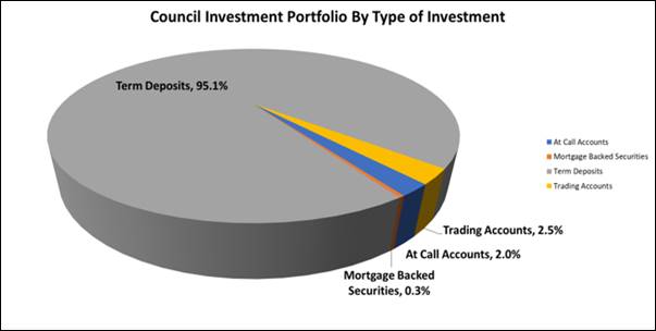
The Investment Report shows that Council has total cash and
investments of $207,563,253 comprising:
|
· Trading Accounts
|
$5,265,995
|
|
· Investments
|
$202,297,258
|
The
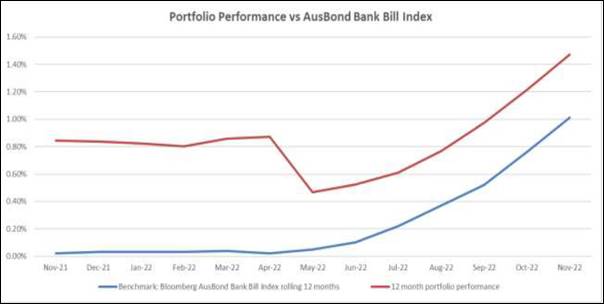
portfolio achieved a return of 0.291% for the month of November which was
0.041% above the benchmark AusBond Bank Bill Index return of 0.25%. For the
past 12 months the portfolio achieved a return of 1.472% which was 0.462% above
the benchmark AusBond Bank Bill Index return of 1.01%.
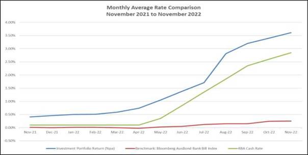
The weighted average interest rate of the portfolio is 3.61%
compared to 3.40% for the prior month. For the past 12 months the weighted
average interest rate of the portfolio was 1.66% compared to the average Ausbond
Bank Bill movement of 0.08% and the average Reserve Bank of Australia Cash Rate
of 1.06%.
Certification –
Responsible Accounting Officer
I hereby certify that the investments listed in the attached
reports have been made in accordance with section 625 of the Local
Government Act 1993, section 212 of the Local Government (General)
Regulation 2021 and existing Investment Policies.
RECOMMENDATION OF Director Corporate and Legal
That Council note the Investment Report as of 30 November
2022, including the certification by the Responsible Accounting Officer.
BACKGROUND
In accordance with section 212 of the Local Government
(General) Regulation 2021, a report setting out the details of money invested
must be presented to Council on a monthly basis.
The report must also include certification as to whether or
not the investments have been made in accordance with the Act, the Regulations
and Council’s Investment Policy.
LINK TO STRATEGY
This report relates to the Community Strategic Plan Outcome
of:
· Good
governance - Goal 19 Our Council is transparent and trusted to make decisions
that reflect the values of the community
financial considerations
Actual investment income for the period from 1 July 2022 to
date was $2,176,095 compared to budgeted income of $249,700, a positive
variance of $1,926,395.
social considerations
Council’s investments are managed in accordance with
Council’s Investment Policy. Council’s Investment Policy requires
consideration of social responsibility when making investment decisions.
environmental considerations
Council’s investments are managed in accordance with
Council’s Investment Policy. Council’s Investment Policy requires
consideration of environmental responsibility when making investment decisions.
governance and risk
considerations
A revised Investment Policy was adopted by Council at its
meeting on 26 July 2022. The Policy is reviewed annually by the Audit, Risk and
Improvement Committee. It was reviewed by the Committee at their meeting in
December 2022, and no changes to the Policy were proposed, with the next review
by the Committee due by December 2023.
Council’s Investment Strategy
was reviewed in November 2022 by Council’s Investment Advisors, Laminar
Capital Pty Ltd, who confirmed that the current policy “remains
consistent with the Ministerial Investment Order and guidelines issued by the
Chief Executive (Local Government), Department of Premier and Cabinet”
and that they “do not recommend any changes to the list of approved
investments or credit limit frameworks”.
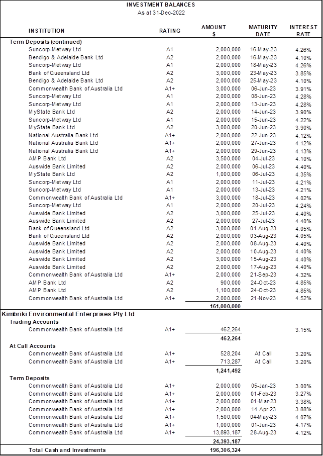
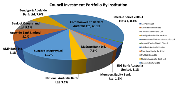
Investment Balances
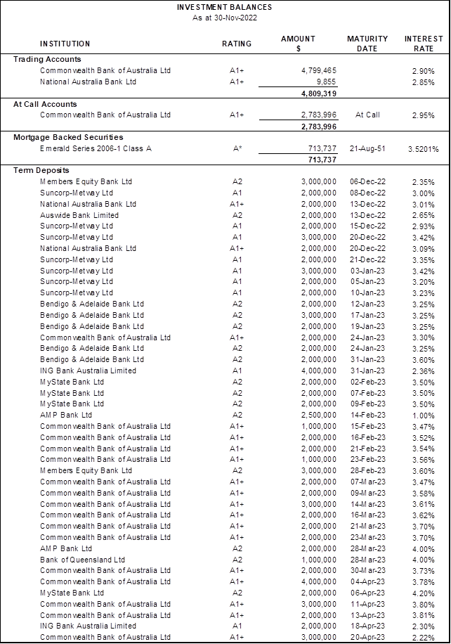
*Rating is based on
a private rating advised by the issuer to Council’s Investment Advisors.
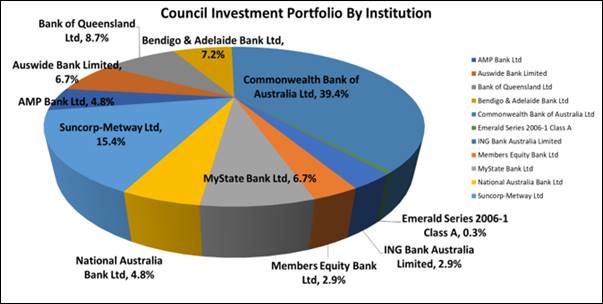
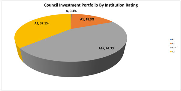
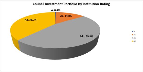
Portfolio Analysis
Institutional Credit Framework – Compliance with Investment
Policy Requirements
Clause 4.2.2 of Council’s Investment Policy requires
that the exposure to an individual institution be restricted by their credit
rating so that single entity exposure is limited, as detailed in the table
below:
|
S&P
Long Term Rating*
|
S&P
Short Term Rating*
|
Maximum %
|
Portfolio
Complies with Policy?
|
|
AAA
(incl. government guaranteed
deposits)
|
A-1+
|
50%
|
Yes
|
|
AA+
|
|
AA
|
|
AA-
|
|
A+
|
A-1
|
40%
|
Yes
|
|
A
|
|
A-
|
A-2
|
30%
|
Yes
|
|
BBB+
|
|
BBB
|
|
BBB-
|
A-3
|
10%
|
Yes
|
|
Unrated**TCorp Funds
|
Unrated**
|
5%
|
Yes ($Nil)
|
|
Unrated***ADIs
|
Unrated***
|
$250,000
|
Yes ($Nil)
|
* Or Moody’s / Fitch equivalents
** Unrated
Category is restricted to eligible managed funds such as the NSW Treasury
Corporation Hour Glass Facilities
*** Unrated
ADIs Category is restricted to those ADIs that are under the Australian
government guarantee scheme and limited to maximum $250,000 per unrated ADI.
As Members Equity Bank is a fully owned subsidiary of Bank
of Queensland, the holdings are combined to determine the maximum percentage
which can be held under clause 4.2.2 (Institutional Credit Framework Guidelines)
of Council’s Investment Policy.
Overall Portfolio Credit Framework – Compliance with Investment
Policy Requirements
Clause 4.2.1 of Council’s Investment Policy requires
that the total percentage exposure within the market to any particular credit
rating category be limited, as detailed in the table below:
|
S&P
Long Term Rating*
|
S&P
Short Term Rating*
|
Maximum %
|
Portfolio
Complies with Policy?
|
|
AAA
(incl. government
guaranteed deposits)
|
A-1+
|
100%
|
Yes
|
|
AA+
|
|
AA
|
|
AA-
|
|
A+
|
A-1
|
100%
|
Yes
|
|
A
|
|
A-
|
A-2
|
80%
|
Yes
|
|
BBB+
|
|
BBB
|
|
BBB-
|
A-3
|
30%
|
Yes
|
|
Unrated**
|
Unrated**
|
5%
|
Yes ($Nil)
|
* Or Moody’s / Fitch equivalents
** Unrated
Category is restricted to eligible managed funds such as the NSW Treasury
Corporation Hour Glass Facilities and ADIs covered by the government guarantee
scheme.
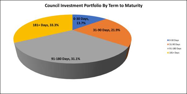
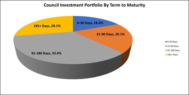
Term to Maturity Framework
– Compliance with Investment Policy Requirements
Clause 4.2.4 of Council’s Investment Policy requires
Council’s investment portfolio is to be invested within the following
maturity constraints:
|
Overall Portfolio Term to Maturity
Limits
|
Portfolio Complies with Policy?
|
|
Portfolio
% <1 year
|
Min 40%
|
Max 100%
|
Yes
|
|
Portfolio
% >1 year ≤3 year
|
Min 0%
|
Max 60%
|
Yes
|
|
Portfolio
% >3 year ≤5 year
|
Min 0%
|
Max 30%
|
Yes
|
Investment
Performance vs Benchmark
a) Portfolio
Return vs Benchmark
|
|
Investment Portfolio Return *
|
Benchmark: AusBond Bank Bill
Index
|
|
1 month
|
0.291%
|
0.25%
|
|
3 Months
|
0.798%
|
0.64%
|
|
FYTD
|
1.106%
|
0.92%
|
|
12 Months
|
1.472%
|
1.01%
|
* Excludes trading account balances
Council’s Investment Advisors have stated this
form of portfolio reporting conforms to global investment performance standards
and that these standards say that periods below 12 months should not be
annualised
The above table shows a
comparison of Council’s investment portfolio return to the benchmark.
Council’s Investment Advisor, Laminar Capital, has created an
accumulation index for the portfolio which increases each month by the
portfolio internal rate of return to enable meaningful comparison to the benchmark
AusBond Bank Bill index, which is an accumulation index.
The Bloomberg AusBond Bank Bill
Index is engineered to measure the Australian money market by representing a
passively managed short term money market portfolio. This index is comprised of
13 synthetic instruments defined by rates interpolated from the RBA 24-hour
cash rate, 1M BBSW, and 3M BBSW.
The
portfolio achieved a return of 0.291% for the month of November which was
0.041% above the benchmark AusBond Bank Bill Index return of 0.25%. For the
past 12 months the portfolio achieved a return of 1.472% which was 0.462% above
the benchmark AusBond Bank Bill Index return of 1.01%.
b) Portfolio
Interest Rate vs Benchmarks
|
|
Weighted Average Portfolio
Interest Rate (%pa) *
|
Average Benchmark: AusBond
Bank Bill Index
|
Average
RBA Cash Rate
|
|
1 month
|
3.61%
|
0.25%
|
2.85%
|
|
3 Months
|
3.40%
|
0.21%
|
2.60%
|
|
6 Months
|
2.69%
|
0.16%
|
1.98%
|
|
FYTD
|
2.95%
|
0.18%
|
2.20%
|
|
12 Months
|
1.66%
|
0.08%
|
1.06%
|
* Excludes trading account balances
The above table shows the weighted average interest rate of the portfolio as
at month end. This is an average of all the interest rates that each term
deposit is earning. It is the current earning rate of the portfolio and this
information is useful as it shows how the earning rate is changing each month
in line with changes in market interest rates. Each time a term deposit matures
during the month it is being reinvested at current interest rates. To
facilitate meaningful comparison, the weighted average interest rate of the
portfolio is compared to the average AusBond Bank Bill Index and average RBA
Cash Rate for the same period.
The weighted average interest rate of the portfolio is
3.61% compared to 3.40% for the prior month. For the past 12 months the weighted
average interest rate of the portfolio was 1.66% compared to the average
Ausbond Bank Bill movement of 0.08% and the average Reserve bank of Australia
Cash Rate of 1.06%.
Monthly Investment Income* vs Budget
|
|
November 2022
$
|
Year to Date
$
|
|
Investment Income
|
567,528
|
2,164,474
|
|
Adjustment for Fair Value
|
9,375
|
11,621
|
|
Total Investment Income
|
576,903
|
2,176,095
|
|
|
|
|
|
Budgeted Income
|
57,100
|
249,700
|
*Includes
all cash and investment holdings


Statement of Compliance
|
Portfolio
Performance vs Bank Bill Index over 12-month period.
|
✔
|
Council’s
investment performance did exceed benchmark.
|
|
Monthly
Income vs Budget
|
✔
|
Council’s
income from investments did exceed monthly budget.
|
|
Investment
Policy Compliance
|
|
|
|
Legislative
Requirements
|
✔
|
Fully
compliant
|
|
Portfolio
Credit Rating Limit
|
✔
|
Fully
compliant
|
|
Institutional
Exposure Limits
|
✔
|
Fully
compliant
|
|
Term
to Maturity Limits
|
✔
|
Fully
compliant
|
Restricted
cash, cash equivalents and investments
The breakdown of restrictions is not available for the
current month within the timeframe for the completion of the Monthly
Investment. Accordingly, the total cash and investments and restrictions
related thereto are presented for the previous month.
At the end
of October 2022 total cash & investments were $195,360,642 and were made up
of the following reserve allocations.
|
Allocation of Funds
|
Amount ($)
|
Percentage
|
|
Externally Restricted
|
48,158,636
|
24.65%
|
|
Internally Restricted
|
80,186,843
|
41.05%
|
|
Total Restricted
|
128,345,479
|
65.70%
|
|
Unrestricted
|
67,015,163
|
34.30%
|
|
Total
|
$195,360,642
|
100.00%
|
ECONOMIC
NOTES
(Source: Primarily extracted from information supplied by
Laminar Capital Pty Ltd)
Most leading economic
indicators and rising central banks’ official interest rates point
towards global recession, but the latest household spending and labour market
data in the US, Europe and Australia are still showing resilience. Annual
inflation readings showed more signs of topping out in November in the US and
Europe while Australia seems to be closing in on peak annual inflation. Central
banks are starting to talk about hiking official interest rates in smaller
increments although most still announced large hikes in November. The path
still looks a long one towards returning annual inflation to central
banks’ targets indicating that once official interest rates peak, the
stay at the peak may be longer than it has been in the past – around
three months on average for the US.
In the US, leading
economic indicators weakened further in November. Housing indicators were weak
mostly. The November National Association of Homebuilders’ index fell to
a cycle low 33 from 38 in October, a far cry from the 70+ readings a year ago.
October building permits, housing starts, and existing home sales fell
respectively m-o-m by 2.4%; 4.2%; and 5.9%. Exceptions to the weakness in the
housing figures were September pending home sales, up 0.8% m-o-m and October
new home sales, up 7.5%. The October ISM purchasing managers’ reports for
the manufacturing and non-manufacturing sectors slipped to respectively 50.2
(September 50.9) and 54.4 (September 56.7). The November readings out in early
December are likely to see at least one slip below the 50 expansion/contraction
line, although readings in the low-to-mid 40s in the past have been harbingers
of recession.
In China, economic data
released in November remained weak beset by the continuing downturn in the
property sector, the lockdowns used to control Omicron outbreaks, and softening
global demand for China’s exports. October exports and imports were both
weaker than expected. October fixed asset investment spending moderated to
+5.8% y-o-y from +5.9% in September and October industrial production to +5.2%
y-o-y from +6.3% y-o-y in September. The greatest damage from sporadic and
unpredictable covid-containment lockdowns showed in retail sales, 0.5% y-o-y in
October from +2.5% y-o-y in September. Rare signs of opposition to President Xi
and his policies showed in civil protests in some cities. China’s
economic growth rate will continue to languish while current lockdown policies persist.
An ill wind on the economic growth front is delivering inflation that is very
low by international standards.
Europe continues to
teeter on the edge of recession but is not quite there yet. A milder than usual
autumn so far in Western Europe is providing hope that energy supply shortages
and price hikes may not be as great as widely feared in the approaching winter.
European Q3 GDP growth lifted 0.2% q-o-q, 2.1% y-o-y. Leading European economic
indicators point towards recession with the November manufacturing and service
sectors PMIs at respectively, 47.3 and 48.6. September retail sales rose 0.3%
m-o-m and the unemployment rate is still hugging the cycle low point at 6.6%.
CPI inflation at 10.6% y-o-y in October was probably at its peak for this cycle
but is unlikely to recede fast given that producer prices are up over 40%
y-o-y. The ECB is indicating that fighting high inflation is the key policy
aim, even at the risk of adding to the risk of recession. In the UK, where
economic growth has turned negative, the Bank of England has no choice but to
continue hiking interest rates to contain double-digit annual inflation.
Australia is an example
of the split between soft leading economic indicators and surprisingly strong
coincident and lagging indicators threatening to keep inflation too high for
too long. Housing activity at the leading edge continued to weaken in November
under pressure from higher borrowing interest rates. House prices are falling
at the fastest pace in 40 years. In September, the value of housing finance
commitments was down by 8.2% m-o-m and down by 18.5% y-o-y. September home
building approvals were down by 5.8% m-o-m and were down by 13.0% y-o-y. As
more fixed-rate home loans written in 2020 and 2021 come up for renewal over coming
months and the RBA hikes the cash rate at least two more times, housing
activity looks set to weaken further.
|

|
Report To Ordinary Council MEETING
|
|
ITEM NO. 9.4 - 28 February 2023
|
pp
|
ITEM 9.4
|
Monthly
Investment Report - December 2022
|
|
REPORTING MANAGER
|
Chief
Financial Officer
|
|
TRIM file
REF
|
2023/009842
|
|
ATTACHMENTS
|
Nil
|
purpose
To provide a report setting out details of all money that
Council has invested under section 625 of the Local Government Act 1993.
executive summary
In accordance with section 212 of the Local Government
(General) Regulation 2021, a report setting out the details of money invested
must be presented to Council on a monthly basis.
The report must also include certification as to whether or
not the investments have been made in accordance with the Act, the Regulations
and Council’s Investment Policy.
The Investment Report shows that Council has total cash and
investments of $196,306,324 comprising:
|
· Trading Accounts
|
$4,030,625
|
|
· Investments
|
$192,275,699
|
The portfolio achieved a return of
0.311% for the month of November which was 0.061% above the benchmark AusBond
Bank Bill Index return of 0.25%. For the past 12 months the portfolio achieved
a return of 1.754% which was 0.504% above the benchmark AusBond Bank Bill Index
return of 1.25%.
The weighted average interest rate of the portfolio is 3.70%
compared to 3.61% for the prior month. For the past 12 months the weighted
average interest rate of the portfolio was 1.93% compared to the average Ausbond
Bank Bill movement of 0.10% and the average Reserve Bank of Australia Cash Rate
of 1.31%.
Certification –
Responsible Accounting Officer
I hereby certify that the investments listed in the attached
reports have been made in accordance with section 625 of the Local
Government Act 1993, section 212 of the Local Government (General)
Regulation 2021 and existing Investment Policies.
RECOMMENDATION OF Director Corporate and Legal
That Council note the Investment Report as at 31 December
2022, including the certification by the Responsible Accounting Officer.
BACKGROUND
In accordance with section 212 of the Local Government
(General) Regulation 2021, a report setting out the details of money invested
must be presented to Council on a monthly basis.
The report must also include certification as to whether or
not the investments have been made in accordance with the Act, the Regulations
and Council’s Investment Policy.
LINK TO STRATEGY
This report relates to the Community Strategic Plan Outcome
of:
· Good
governance - Goal 19 Our Council is transparent and trusted to make decisions
that reflect the values of the community
financial considerations
Actual investment income for the period from 1 July 2022 to
date was $2,807,131 compared to budgeted income of $307,400, a positive
variance of $2,499,731.
social considerations
Council’s investments are managed in accordance with
Council’s Investment Policy. Council’s Investment Policy requires
consideration of social responsibility when making investment decisions.
environmental considerations
Council’s investments are managed in accordance with
Council’s Investment Policy. Council’s Investment Policy requires
consideration of environmental responsibility when making investment decisions.
governance and risk
considerations
A revised Investment Policy was adopted by Council at its meeting
on 26 July 2022. The Policy is reviewed annually by the Audit, Risk and
Improvement Committee. It was reviewed by the Committee at their meeting in
December 2022, and no changes to the Policy were proposed, with the next review
by the Committee due by December 2023.
Council’s Investment Strategy was reviewed in November
2022 by Council’s Investment Advisors, Laminar Capital Pty Ltd, who
confirmed that the current policy “remains consistent with the
Ministerial Investment Order and guidelines issued by the Chief Executive
(Local Government), Department of Premier and Cabinet” and that they
“do not recommend any changes to the list of approved investments or
credit limit frameworks”.
Investment Balances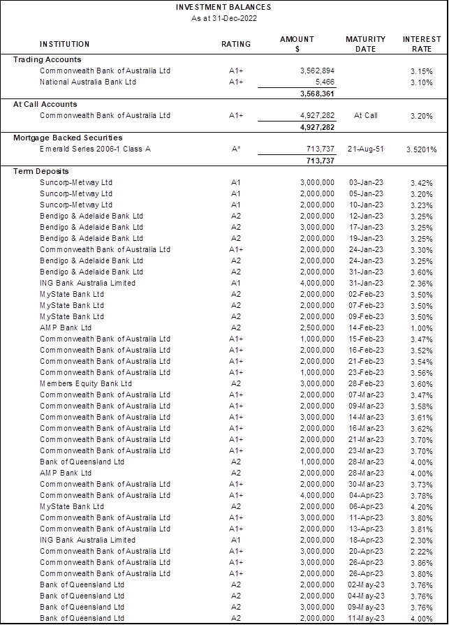
*Rating is based on
a private rating advised by the issuer to Council’s Investment Advisors.
Portfolio
Analysis
Institutional Credit Framework – Compliance with Investment
Policy Requirements
Clause 4.2.2 of Council’s Investment Policy requires
that the exposure to an individual institution be restricted by their credit
rating so that single entity exposure is limited, as detailed in the table
below:
|
S&P
Long Term Rating*
|
S&P
Short Term Rating*
|
Maximum %
|
Portfolio
Complies with Policy?
|
|
AAA
(incl. government
guaranteed deposits)
|
A-1+
|
50%
|
Yes
|
|
AA+
|
|
AA
|
|
AA-
|
|
A+
|
A-1
|
40%
|
Yes
|
|
A
|
|
A-
|
A-2
|
30%
|
Yes
|
|
BBB+
|
|
BBB
|
|
BBB-
|
A-3
|
10%
|
Yes
|
|
Unrated**TCorp Funds
|
Unrated**
|
5%
|
Yes ($Nil)
|
|
Unrated***ADIs
|
Unrated***
|
$250,000
|
Yes ($Nil)
|
* Or Moody’s / Fitch equivalents
** Unrated
Category is restricted to eligible managed funds such as the NSW Treasury
Corporation Hour Glass Facilities
*** Unrated
ADIs Category is restricted to those ADIs that are under the Australian
government guarantee scheme and limited to maximum $250,000 per unrated ADI.
As Members Equity Bank is a fully owned subsidiary of Bank
of Queensland, the holdings are combined to determine the maximum percentage
which can be held under clause 4.2.2 (Institutional Credit Framework
Guidelines) of Council’s Investment Policy.
Overall Portfolio Credit Framework – Compliance with Investment
Policy Requirements
Clause 4.2.1 of Council’s Investment Policy requires
that the total percentage exposure within the market to any particular credit
rating category be limited, as detailed in the table below:
|
S&P
Long Term Rating*
|
S&P
Short Term Rating*
|
Maximum %
|
Portfolio
Complies with Policy?
|
|
AAA
(incl. government
guaranteed deposits)
|
A-1+
|
100%
|
Yes
|
|
AA+
|
|
AA
|
|
AA-
|
|
A+
|
A-1
|
100%
|
Yes
|
|
A
|
|
A-
|
A-2
|
80%
|
Yes
|
|
BBB+
|
|
BBB
|
|
BBB-
|
A-3
|
30%
|
Yes
|
|
Unrated**
|
Unrated**
|
5%
|
Yes ($Nil)
|
* Or Moody’s / Fitch equivalents
** Unrated
Category is restricted to eligible managed funds such as the NSW Treasury
Corporation Hour Glass Facilities and ADIs covered by the government guarantee
scheme.
Term to Maturity Framework
– Compliance with Investment Policy Requirements
Clause 4.2.4 of Council’s Investment Policy requires
Council’s investment portfolio is to be invested within the following
maturity constraints:
|
Overall Portfolio Term to Maturity
Limits
|
Portfolio Complies with Policy?
|
|
Portfolio
% <1 year
|
Min 40%
|
Max 100%
|
Yes
|
|
Portfolio
% >1 year ≤3 year
|
Min 0%
|
Max 60%
|
Yes
|
|
Portfolio
% >3 year ≤5 year
|
Min 0%
|
Max 30%
|
Yes
|
Investment
Performance vs Benchmark
a) Portfolio
Return vs Benchmark
|
|
Investment Portfolio Return *
|
Benchmark: AusBond Bank Bill
Index
|
|
1 month
|
0.311%
|
0.25%
|
|
3 Months
|
0.875%
|
0.74%
|
|
FYTD
|
1.419%
|
1.17%
|
|
12 Months
|
1.754%
|
1.25%
|
* Excludes trading account balances
Council’s Investment Advisors have stated this
form of portfolio reporting conforms to global investment performance standards
and that these standards say that periods below 12 months should not be
annualised
The above table shows a
comparison of Council’s investment portfolio return to the benchmark.
Council’s Investment Advisor, Laminar Capital, has created an
accumulation index for the portfolio which increases each month by the
portfolio internal rate of return to enable meaningful comparison to the benchmark
AusBond Bank Bill index, which is an accumulation index.
The Bloomberg AusBond Bank Bill
Index is engineered to measure the Australian money market by representing a
passively managed short term money market portfolio. This index is comprised of
13 synthetic instruments defined by rates interpolated from the RBA 24-hour
cash rate, 1M BBSW, and 3M BBSW.
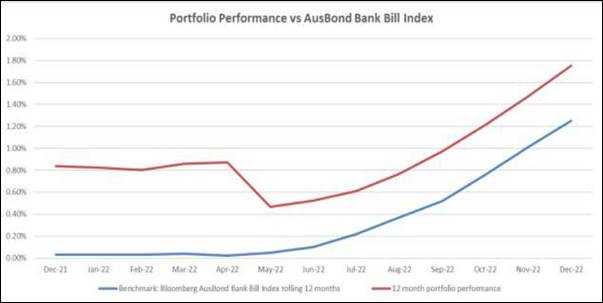
The portfolio achieved a return
of 0.311% for the month of December which was 0.061% above the benchmark
AusBond Bank Bill Index return of 0.25%. For the past 12 months the portfolio
achieved a return of 1.754% which was 0.504% above the benchmark AusBond Bank
Bill Index return of 1.25%.
b) Portfolio
Interest Rate vs Benchmarks
|
|
Weighted Average Portfolio
Interest Rate (%pa) *
|
Average Benchmark: AusBond
Bank Bill Index
|
Average
RBA Cash Rate
|
|
1 month
|
3.70%
|
0.25%
|
3.10%
|
|
3 Months
|
3.57%
|
0.25%
|
2.85%
|
|
6 Months
|
3.07%
|
0.19%
|
2.35%
|
|
FYTD
|
3.07%
|
0.19%
|
2.35%
|
|
12 Months
|
1.93%
|
0.10%
|
1.31%
|
* Excludes trading account balances
The above table shows the
weighted average interest rate of the portfolio as at month end. This is an
average of all the interest rates that each term deposit is earning. It is the
current earning rate of the portfolio and this information is useful as it shows
how the earning rate is changing each month in line with changes in market
interest rates. Each time a term deposit matures during the month it is being
reinvested at current interest rates. To facilitate meaningful comparison, the
weighted average interest rate of the portfolio is compared to the average
AusBond Bank Bill Index and average RBA Cash Rate for the same period.
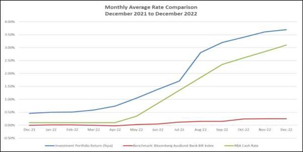
The weighted average interest rate of the portfolio is
3.70% compared to 3.61% for the prior month. For the past 12 months the weighted
average interest rate of the portfolio was 1.93% compared to the average
Ausbond Bank Bill movement of 0.10% and the average Reserve bank of Australia
Cash Rate of 1.31%.
Monthly Investment Income* vs Budget
|
|
December 2022
$
|
Year to Date
$
|
|
Investment Income
|
631,036
|
2,795,510
|
|
Adjustment for Fair Value
|
0
|
11,621
|
|
Total Investment Income
|
631,036
|
2,807,131
|
|
|
|
|
|
Budgeted Income
|
57,700
|
307,400
|
*Includes
all cash and investment holdings


Statement of Compliance
|
Portfolio
Performance vs Bank Bill Index over 12-month period.
|
✔
|
Council’s
investment performance did exceed benchmark.
|
|
Monthly
Income vs Budget
|
✔
|
Council’s
income from investments did exceed monthly budget.
|
|
Investment
Policy Compliance
|
|
|
|
Legislative
Requirements
|
✔
|
Fully
compliant
|
|
Portfolio
Credit Rating Limit
|
✔
|
Fully
compliant
|
|
Institutional
Exposure Limits
|
✔
|
Fully
compliant
|
|
Term
to Maturity Limits
|
✔
|
Fully
compliant
|
Restricted
cash, cash equivalents and investments
The
breakdown of restrictions is not available for the current month within the
timeframe for the completion of the Monthly Investment. Accordingly, the total
cash and investments and restrictions related thereto are presented for the
previous month.
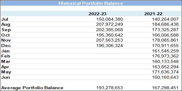
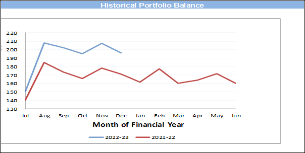
At the end
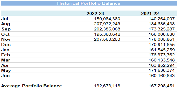
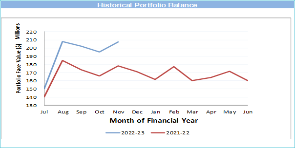
of November 2022 total cash & investments were $207,563,253 and were made
up of the following reserve allocations.
|
Allocation of Funds
|
Amount ($)
|
Percentage
|
|
Externally Restricted
|
48,758,318
|
23.49%
|
|
Internally Restricted
|
78,254,839
|
37.70%
|
|
Total Restricted
|
127,013,157
|
61.19%
|
|
Unrestricted
|
80,550,096
|
38.81%
|
|
Total
|
$207,563,253
|
100.00%
|
ECONOMIC
NOTES
(Source: Primarily extracted from information supplied by
Laminar Capital Pty Ltd)
Bond, credit and share
markets fell in December amid concerns that central banks may need to underpin
higher interest rates for longer to return inflation to their targets. A longer
period of higher interest rates would increase the already high risk of a
global recession developing through 2023. The first week of 2023 has seen
markets take an optimistic turn driven by hope that inflation is starting to
recede and a sign in the US that annual wage growth may have peaked.
The US Federal Reserve
(Fed) has made it clear that the tightness of the US labour market is what it
is watching most keenly to determine whether inflation will return to target
over time. While the wage growth reading in the December payrolls report says
peak wage growth has passed, the strength of other readings including strong
non-farm payrolls growth (up 223,000 in December) and the unemployment rate
falling to 3.5% from 3.6% in November say that US labour market conditions are
still very tight.
Financial market
optimism in the first week of 2023 is likely to be challenged if the Fed sticks
to its script of doing what is necessary to return inflation to 2% target over
time. Even if annual US CPI inflation falls again when the December reading is
released later this week (market expectation +0.1% m-o-m, +6.5% y-o-y from
+0.1%, 7.1% in November), low unemployment in December and annual growth in
average hourly earnings although down to 4.6% y-o-y, still imply the best hope
for US annual inflation is that it falls to 4% over the next year, double the
Fed’s target.
The first Fed policy
meeting of 2023 at the end of this month is likely to see another hike in the
Fed funds rate from 4.50%, probably to 5.00% and that still may not be the last
rate hike.
Back in December,
financial markets were still attuned to the idea that not only the US Federal
Reserve, but most other central banks, still had more work ahead lifting
official interest rates. Major share markets mostly fell between 1.6% for the
FTSE 100 and 5.9% for the US S&P 500. Australia’s ASX 200 fell by
3.6%. Exceptions to the share market losses were China’s CSI 300, up 0.4%
and Hong Kong’s Hang Seng, up 5.9%, both markets responding positively to
China’s rapid removal of Covid restrictions.
Credit markets weakened
in December and like other markets have found a little strength early in 2023.
So far, the deterioration in Australian credit quality has been modest.
Essentially, very strong employment conditions are helping Australian
households cope with higher interest payments on debt. It remains less certain
whether Australia will experience recession in 2023 widely expected for the US
and Europe. A more resilient Australian economy than elsewhere may come with
the sting in the tail that the RBA has a relatively tougher task ahead bringing
inflation back to 2-3% target range. The RBA’s official interest rate
currently at 3.10% may not need to be raised much more, but it may need to be
held at a higher rate for longer and with relatively little leeway for rate
cuts further down the track.
Australian housing, the
most interest rate sensitive part of the Australian economy and already the
weakest part of the economy is likely to suffer further decline through 2023.
Previous RBA policy actions are having lagged effect on housing. Variable interest
rate mortgage borrowers are just starting to feel the impact in their monthly
repayments of the November and December RBA rate decisions.
Two and three-year fixed
rate mortgage borrowers who entered their commitment in boom-time numbers back
in 2020 and 2021 at very low interest rates face rolling over at monthly
repayments double and more in the first few months of 2023. Mortgage repayment
pain intensifies sharply early this year and could become acute later in the
year if the labour market weakens.
At the start of 2023 the
task facing the RBA remains challenging. Annual inflation may top out less than
8.0% y-o-y forecast previously courtesy of less extreme upward pressure on
petrol and food prices. However, the resilience of the economy and the labour
market point to inflation being stickier on the way down and unlikely to return
to 2-3% target band this year or next year.
|

|
Report To Ordinary Council MEETING
|
|
ITEM NO. 9.5 - 28 February 2023
|
pp
|
ITEM 9.5
|
Monthly
Investment Report - January 2023
|
|
REPORTING MANAGER
|
Chief
Financial Officer
|
|
TRIM file
REF
|
2023/077695
|
|
ATTACHMENTS
|
Nil
|
purpose
To provide a report setting out details of all money that Council
has invested under section 625 of the Local Government Act 1993.
executive summary
In accordance with section 212 of the Local Government
(General) Regulation 2021, a report setting out the details of money invested
must be presented to Council on a monthly basis.
The report must also include certification as to whether or
not the investments have been made in accordance with the Act, the Regulations
and Council’s Investment Policy.
The Investment Report shows that Council has total cash and
investments of $187,257,340 comprising:
|
· Trading Accounts
|
$2,029,272
|
|
· Investments
|
$185,228,068
|
The portfolio achieved a return of
0.307% for the month of January which was 0.037% above the benchmark AusBond
Bank Bill Index return of 0.27%. For the past 12 months the portfolio achieved
a return of 2.032% which was 0.512% above the benchmark AusBond Bank Bill Index
return of 1.52%.
The weighted average interest rate of the portfolio is 3.85%
compared to 3.70% for the prior month. For the past 12 months the weighted
average interest rate of the portfolio was 2.21% compared to the average Ausbond
Bank Bill movement of 0.13% and the average Reserve Bank of Australia Cash Rate
of 1.56%.
Certification –
Responsible Accounting Officer
I hereby certify that the investments listed in the attached
reports have been made in accordance with section 625 of the Local
Government Act 1993, section 212 of the Local Government (General)
Regulation 2021 and existing Investment Policies.
RECOMMENDATION OF Director Corporate and Legal
That Council note the Investment Report as at 31 January
2023, including the certification by the Responsible Accounting Officer.
BACKGROUND
In accordance with section 212 of the Local Government
(General) Regulation 2021, a report setting out the details of money invested
must be presented to Council on a monthly basis.
The report must also include certification as to whether or
not the investments have been made in accordance with the Act, the Regulations
and Council’s Investment Policy.
LINK TO STRATEGY
This report relates to the Community Strategic Plan Outcome
of:
· Good
governance - Goal 19 Our Council is transparent and trusted to make decisions
that reflect the values of the community
financial considerations
Actual investment income for the period from 1 July 2022 to
date was $3,410,265 compared to budgeted income of $359,000, a positive
variance of $3,051,265.
social considerations
Council’s investments are managed in accordance with
Council’s Investment Policy. Council’s Investment Policy requires
consideration of social responsibility when making investment decisions.
environmental considerations
Council’s investments are managed in accordance with
Council’s Investment Policy. Council’s Investment Policy requires
consideration of environmental responsibility when making investment decisions.
governance and risk
considerations
A revised Investment Policy was adopted by Council at its meeting
on 26 July 2022. The Policy is reviewed annually by the Audit, Risk and
Improvement Committee. It was reviewed by the Committee at their meeting in
December 2022, and no changes to the Policy were proposed, with the next review
by the Committee due by December 2023.
Council’s Investment Strategy was reviewed in November
2022 by Council’s Investment Advisors, Laminar Capital Pty Ltd, who
confirmed that the current policy “remains consistent with the
Ministerial Investment Order and guidelines issued by the Chief Executive
(Local Government), Department of Premier and Cabinet” and that they
“do not recommend any changes to the list of approved investments or
credit limit frameworks”.
Investment Balances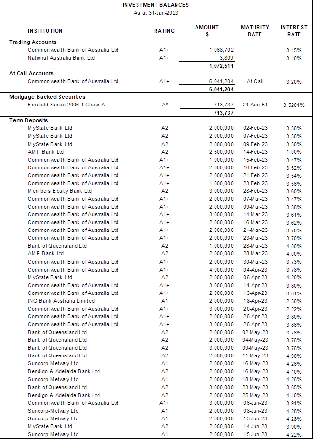
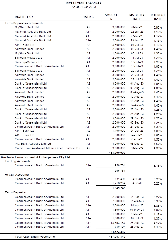
*Rating is based on
a private rating advised by the issuer to Council’s Investment Advisors.
Portfolio
Analysis
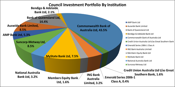
Institutional Credit Framework – Compliance with Investment
Policy Requirements
Clause 4.2.2 of Council’s Investment Policy requires
that the exposure to an individual institution be restricted by their credit
rating so that single entity exposure is limited, as detailed in the table
below:
|
S&P
Long Term Rating*
|
S&P
Short Term Rating*
|
Maximum %
|
Portfolio
Complies with Policy?
|
|
AAA
(incl. government
guaranteed deposits)
|
A-1+
|
50%
|
Yes
|
|
AA+
|
|
AA
|
|
AA-
|
|
A+
|
A-1
|
40%
|
Yes
|
|
A
|
|
A-
|
A-2
|
30%
|
Yes
|
|
BBB+
|
|
BBB
|
|
BBB-
|
A-3
|
10%
|
Yes
|
|
Unrated**TCorp Funds
|
Unrated**
|
5%
|
Yes ($Nil)
|
|
Unrated***ADIs
|
Unrated***
|
$250,000
|
Yes ($Nil)
|
* Or Moody’s / Fitch equivalents
** Unrated
Category is restricted to eligible managed funds such as the NSW Treasury
Corporation Hour Glass Facilities
*** Unrated
ADIs Category is restricted to those ADIs that are under the Australian
government guarantee scheme and limited to maximum $250,000 per unrated ADI.
As Members Equity Bank is a fully owned subsidiary of Bank
of Queensland, the holdings are combined to determine the maximum percentage
which can be held under clause 4.2.2 (Institutional Credit Framework
Guidelines) of Council’s Investment Policy.
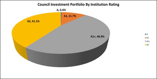
Overall Portfolio Credit Framework – Compliance with Investment
Policy Requirements
Clause 4.2.1 of Council’s Investment Policy requires
that the total percentage exposure within the market to any particular credit
rating category be limited, as detailed in the table below:
|
S&P
Long Term Rating*
|
S&P
Short Term Rating*
|
Maximum %
|
Portfolio
Complies with Policy?
|
|
AAA
(incl. government
guaranteed deposits)
|
A-1+
|
100%
|
Yes
|
|
AA+
|
|
AA
|
|
AA-
|
|
A+
|
A-1
|
100%
|
Yes
|
|
A
|
|
A-
|
A-2
|
80%
|
Yes
|
|
BBB+
|
|
BBB
|
|
BBB-
|
A-3
|
30%
|
Yes
|
|
Unrated**
|
Unrated**
|
5%
|
Yes ($Nil)
|
* Or Moody’s / Fitch equivalents
** Unrated
Category is restricted to eligible managed funds such as the NSW Treasury
Corporation Hour Glass Facilities and ADIs covered by the government guarantee
scheme.
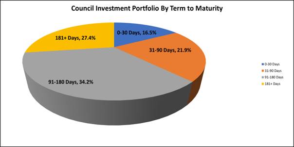
Term to Maturity Framework
– Compliance with Investment Policy Requirements
Clause 4.2.4 of Council’s Investment Policy requires
Council’s investment portfolio is to be invested within the following
maturity constraints:
|
Overall Portfolio Term to Maturity
Limits
|
Portfolio Complies with Policy?
|
|
Portfolio
% <1 year
|
Min 40%
|
Max 100%
|
Yes
|
|
Portfolio
% >1 year ≤3 year
|
Min 0%
|
Max 60%
|
Yes
|
|
Portfolio
% >3 year ≤5 year
|
Min 0%
|
Max 30%
|
Yes
|
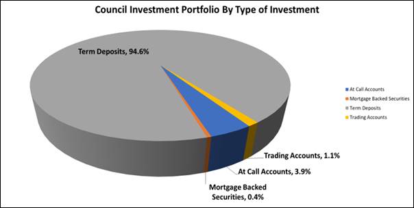
Investment
Performance vs Benchmark
a) Portfolio
Return vs Benchmark
|
|
Investment Portfolio Return *
|
Benchmark: AusBond Bank Bill
Index
|
|
1 month
|
0.307%
|
0.27%
|
|
3 Months
|
0.918%
|
0.77%
|
|
FYTD
|
1.736%
|
1.44%
|
|
12 Months
|
2.032%
|
1.52%
|
* Excludes trading account balances
Council’s Investment Advisors have stated this
form of portfolio reporting conforms to global investment performance standards
and that these standards say that periods below 12 months should not be
annualised
The above table shows a
comparison of Council’s investment portfolio return to the benchmark.
Council’s Investment Advisor, Laminar Capital, has created an
accumulation index for the portfolio which increases each month by the
portfolio internal rate of return to enable meaningful comparison to the benchmark
AusBond Bank Bill index, which is an accumulation index.
The Bloomberg AusBond Bank Bill
Index is engineered to measure the Australian money market by representing a
passively managed short term money market portfolio. This index is comprised of
13 synthetic instruments defined by rates interpolated from the RBA 24-hour
cash rate, 1M BBSW, and 3M BBSW.
The portfolio achieved a return
of 0.307% for the month of January which was 0.037% above the benchmark AusBond
Bank Bill Index return of 0.27%. For the past 12 months the portfolio achieved
a return of 2.032% which was 0.512% above the benchmark AusBond Bank Bill Index
return of 1.52%.
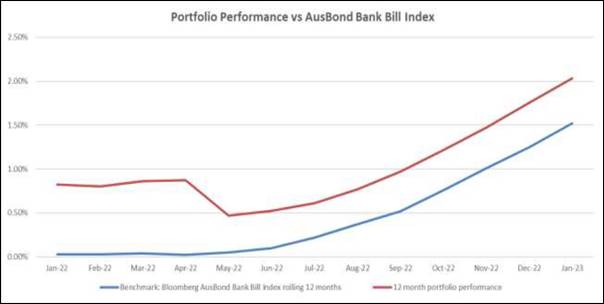
b) Portfolio
Interest Rate vs Benchmarks
|
|
Weighted Average Portfolio
Interest Rate (%pa) *
|
Average Benchmark: AusBond
Bank Bill Index
|
Average
RBA Cash Rate
|
|
1 month
|
3.85%
|
0.27%
|
3.10%
|
|
3 Months
|
3.72%
|
0.26%
|
3.02%
|
|
6 Months
|
3.43%
|
0.22%
|
2.64%
|
|
FYTD
|
3.18%
|
0.20%
|
2.46%
|
|
12 Months
|
2.21%
|
0.13%
|
1.56%
|
* Excludes trading account balances
The above table shows the
weighted average interest rate of the portfolio as at month end. This is an
average of all the interest rates that each term deposit is earning. It is the
current earning rate of the portfolio and this information is useful as it shows
how the earning rate is changing each month in line with changes in market
interest rates. Each time a term deposit matures during the month it is being
reinvested at current interest rates. To facilitate meaningful comparison, the
weighted average interest rate of the portfolio is compared to the average
AusBond Bank Bill Index and average RBA Cash Rate for the same period.
The weighted average interest rate of the portfolio is
3.85% compared to 3.70% for the prior month. For the past 12 months the
weighted average interest rate of the portfolio was 2.21% compared to the
average Ausbond Bank Bill movement of 0.13% and the average Reserve bank of
Australia Cash Rate of 1.56%.
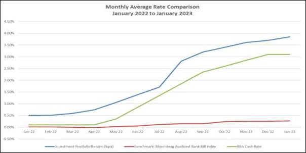
Monthly Investment Income* vs Budget
|
|
January 2023
$
|
Year to Date
$
|
|
Investment Income
|
603,134
|
3,398,644
|
|
Adjustment for Fair Value
|
0
|
11,621
|
|
Total Investment Income
|
603,134
|
3,410,265
|
|
|
|
|
|
Budgeted Income
|
51,600
|
359,000
|
*Includes
all cash and investment holdings
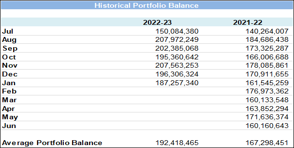
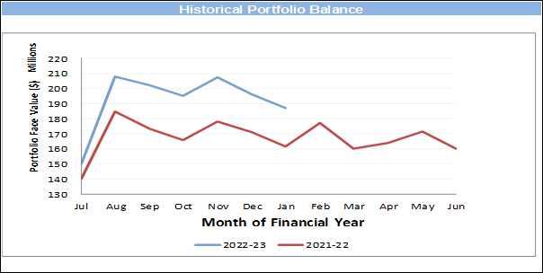
Statement of Compliance
|
Portfolio
Performance vs Bank Bill Index over 12-month period.
|
✔
|
Council’s
investment performance did exceed benchmark.
|
|
Monthly
Income vs Budget
|
✔
|
Council’s
income from investments did exceed monthly budget.
|
|
Investment
Policy Compliance
|
|
|
|
Legislative
Requirements
|
✔
|
Fully
compliant
|
|
Portfolio
Credit Rating Limit
|
✔
|
Fully
compliant
|
|
Institutional
Exposure Limits
|
✔
|
Fully
compliant
|
|
Term
to Maturity Limits
|
✔
|
Fully
compliant
|
Restricted
cash, cash equivalents and investments
The breakdown
of restrictions is not available for the current month within the timeframe for
the completion of the Monthly Investment. Accordingly, the total cash and
investments and restrictions related thereto are presented for the previous
month.
At the end
of December 2022 total cash & investments were $196,306,324 and were made
up of the following reserve allocations.
|
Allocation of Funds
|
Amount ($)
|
Percentage
|
|
Externally Restricted
|
50,787,315
|
25.87%
|
|
Internally Restricted
|
79,627,642
|
40.56%
|
|
Total Restricted
|
130,414,957
|
66.43%
|
|
Unrestricted
|
65,891,367
|
33.57%
|
|
Total
|
$ 196,306,324
|
100.00%
|
ECONOMIC
NOTES
(Source: Primarily extracted from information supplied by
Laminar Capital Pty Ltd)
Recession, feared
previously to start as early as the current northern hemisphere winter starting
in Europe and in the US not long after has been delayed by warm winter weather
in Europe containing energy prices, optimism that central banks are near the end
of their rate hiking cycle as inflation decelerates, and China’s policy
makers switching from tough restraints relating to covid and several big
sectors of the economy most notably on property speculation to swift re-opening
and support. High annual inflation rates have started to fall in the US and
Europe adding to optimism that if recession still lies ahead, it is likely to
be shallow and with a quick recovery as central banks find themselves in a
position to start cutting official interest rates from later this year.
In the US, the pace of
economic growth is slowing, but not much. The advance reading of Q4 2022 GDP
showed 2.9% annualised growth from 3.2% in Q3 and with still good support from
real consumer spending, 2.1% annualised growth in Q4 from 2.3% in Q3. Leading
indicators of US economic activity released in January point to recession, but
the signals are less pronounced than they were a month or two ago. In contrast,
US retail sales have weakened late in 2022 falling 1.1% m-o-m in December after
a 1.0% fall in November. Adding to the picture of mixed-strength US economic
readings, non-farm payrolls continue to rise strongly, up 223,000 in December,
causing the unemployment rate to fall from 3.6% in November to 3.5% in
December, matching the lowest reading since 1969 and a marker of an
exceptionally tight labour market.
In China, economic data
released in January were all firmer than expected although still pointing to
growth well below long term trend. Q4 2022 GDP was flat in the quarter with annual
growth decelerating to 2.9% y-o-y from 3.9% in Q3. December readings showed
fixed asset investment spending up 5.1% y-o-y (November 5.3%); industrial
production up 1.3% y-o-y (November 2.2%); and retail sales down 1.8% y-o-y
(November -5.9%). On the international trade front, December exports were down
9.9% y-o-y (November -8.7%) and imports were down 7.5% y-o-y (November -10.6%).
December saw the beginnings of China reducing restrictions and introducing more
growth friendly policies. The changes in policy direction, while potentially
positive for the growth outlook have come at a price. China’s covid
infection rate has soared with the removal of lockdown restrictions.
A few months ago, Europe
was tipped to slide into recession in the northern winter months amid a
worsening energy supply and price crisis. A much warmer than usual winter plus
better access to energy supplies derailed the energy crisis and has allowed the
European economy to continue growing. Leading economic indicators, while still
soft, have lifted a little. Europe’s unemployment rate at 6.5% is the
lowest this century and still marks a very tight labour market. Annual
inflation appears to have peaked above 10% y-o-y and was down to 9.2% y-o-y in
December. While the onset of recession has been delayed it is still likely to
occur as both the European Central Bank and the Bank of England have become
among the more strident talking about the need to contain inflation. The ECB
and Bank of England both meet later this week and are expected to deliver 50bps
rate hike taking the ECB deposit rate to 2.50% and the Bank of England Base
Rate to 4.00%. These expected rate hikes will not be the last given widespread
industrial disruption throughout Europe calling for higher wages.
In Australia, most economic
indicators released in January, other than those related to housing activity,
remained strong. Annual inflation is still rising and a little more than
expected. The Q3 CPI rose by 1.9% q-o-q, lifting annual CPI inflation to 7.8%
y-o-y from 7.3% in Q3. The underlying inflation measures removing some of the
volatile items were also surprisingly high with the trimmed mean up 1.7% q-o-q
lifting the annual rate to 6.9% y-o-y from 6.1%.
Another sign that
inflation is yet to peak came with the monthly CPI reading for December showing
annual inflation lifting to 8.4% y-o-y from 7.3% in November. High Q1 inflation
readings in 2022 mean there is a strong likelihood that Australian annual inflation
will start to moderate in Q1 2023, but probably not by much.
|

|
Report To Ordinary Council MEETING
|
|
ITEM NO. 10.1 - 28 February 2023
|
10.0 Community and Belonging
Division Reports
|
ITEM 10.1
|
Council
Representation to the Quarantine Station Community Consultative Committee
|
|
REPORTING
MANAGER
|
Director
Community & Belonging
|
|
TRIM
file REF
|
2023/007196
|
|
ATTACHMENTS
|
NIL
|
purpose
To endorse a Councillor representative to the Quarantine
Station Community Consultative Committee for a period of 4 years.
executive summary
The North Head Quarantine Station has been
adaptively re-used as a cultural tourism facility since 2006.
The planning approval granted in 2003
associated with this adaptive re-use requires that a Quarantine Station
Community Consultative Committee be established for the term of the approval.
The role of the Committee is to provide
comment and recommendations in an advisory capacity to the National Parks and
Wildlife Service (NPWS) and the lessee, on proposals or relevant matters
including environmental reports, audits, the reviews of site wide plans, and
compliance with the conditions of approval for the operation of the site.
The term of the appointment of
Council’s representative is a period of four years and is due for renewal
in May 2023. At present Councillor Bingham is the appointed Council
representative and the committee meets three to four times per year.
The Manly Ward Councillors have been
consulted and recommend Councillor Bingham to continue to represent
Council’s interests. In accordance with the Northern Beaches Council
Committee Framework adopted in 2022, Council must endorse the representative.
RECOMMENDATION OF Director Community and Belonging
That Council endorse the nomination of Councillor Bingham as
Council’s representative on the Quarantine Station Community Consultative
Committee for a period of 4 years.
BACKGROUND
From 1828 to 1984 the Quarantine Station
was in operation to isolate immigrants to Australia who were liable to be or
suspected of, carrying an infectious disease. The site is listed as an item of
National Heritage significance.
Since 1984 the site has been managed by the
NPWS which is part of the Office of Environment and Heritage (OEH).
Since 2006, the site has been adapted for
cultural tourism purposes and contains a visitor centre, restaurant,
accommodation, conference centre and environment and cultural study centre.
A condition of the Planning Approval required the
establishment of the Quarantine Station Community Consultative Committee which
meets on a regular basis and includes a Councillor representative.
TIMING
The current Committee term will expire in May 2023. Council
is required to endorse its representative prior to that time.
NPWS has written to Council requesting that the nomination
be endorsed as soon as practicable to ensure allow for renewed or new members
to be inducted and trained into the operations of the committee.
LINK TO STRATEGY
This report relates to the Community
Strategic Plan Outcome of:
· Good governance - Goal 19 Our Council is transparent and trusted to
make decisions that reflect the values of the community
· Protection of the environment - Goal 3 Our community is
well-supported in protecting and enhancing the environment to ensure safe and
sustainable use.
financial considerations
The recommendations of this report pose no financial impact
on Council. NPWS provides secretariat and governance support for the Committee.
social considerations
The Quarantine Station Community Consultative Committee is
an effective mechanism for Council to remain involved with the ongoing
operations and future plans for the site.
environmental considerations
The appointment of a Councillor to the committee has no
direct environmental impact.
The committee will consider Environmental Reporting and
Monitoring during its meetings.
governance and risk
considerations
Council’s role is advisory to the NPWS on this
committee, the terms of reference provide for an effective governance framework
for decision making at the Quarantine Station site.
|
|
Report To Ordinary Council MEETING
|
|
ITEM NO. 12.1 - 28 February 2023
|
12.0 Planning and Place Division
Reports
|
ITEM 12.1
|
Planning
Proposal 10-12 Boondah Road, Warriewood PEX2022/0001
|
|
REPORTING
MANAGER
|
Executive
Manager Strategic & Place Planning
|
|
TRIM
file REF
|
2022/580108
|
|
ATTACHMENTS
|
1 ⇨Minutes of Northern Beaches Local Planning Panel
Meeting 21 December 2022 (Included In Attachments Booklet)
2 ⇨NSW State Emergency Service (SES) - Letter of
Advice (Included In Attachments Booklet)
3 ⇨Submissions - Summary of Issues Raised (Included In
Attachments Booklet)
|
purpose
To seek Council’s approval to reject
a Planning Proposal for land at 10-12 Boondah Road, Warriewood, and not
forward the Planning Proposal to the Minister for Planning.
executive summary
Henroth Pty Ltd submitted a
Planning Proposal to amend Pittwater Local Environmental
Plan 2014 by rezoning land at 10-12
Boondah Road, Warriewood from RU2 Rural Landscape to R3 Medium
Density Residential and C2 Environmental Conservation, along with other amendments,
to enable residential development comprising 40 dwellings in a 3-storey townhouse typology and 4
affordable housing dwellings for a 10-year period in a manor home or 2-storey residential flat building typology.
The Planning Proposal has been assessed and
found to be inconsistent with the strategic planning framework and fails to
demonstrate sufficient strategic and site-specific merit, particularly in
relation to flooding, water management, biodiversity impacts, affordable
housing, and overall public benefit.
On 21 December
2022, the Northern Beaches Local Planning Panel (the Panel) considered the
Planning Proposal and recommended that Council reject the Planning Proposal and
not forward it on for a Gateway Determination. The Panel’s full
recommendation is contained in Attachment 1.
RECOMMENDATION OF Director Planning and Place
That:
1. Council rejects the proponent’s Planning Proposal and not
forward it to the Minister for Planning for a Gateway determination for the
following reasons:
A. The Planning Proposal has not demonstrated sufficient strategic
merit or site-specific merit, and is inconsistent with the following elements
of the strategic planning framework:
i. Greater Sydney Region Plan:
Objective 27:
Biodiversity is protected, urban bushland and remnant vegetation is enhanced.
Objective
36: People and places adapt to climate change and future
shocks and stresses.
Objective 37: Exposure to natural and urban
hazards is reduced.
ii. North District Plan:
Planning Priority N16: Protecting and enhancing bushland
and biodiversity
Planning Priority N22: Adapting to the impacts of urban and
natural hazards and climate change
iii. Towards 2040 Local Strategic Planning Statement for the Northern
Beaches:
Priority 1:
Healthy and valued coast and waterways
Priority 2:
Protected and enhanced bushland and biodiversity
Priority 8:
Adapted to the impacts of natural and urban hazards and climate change
Priority 15: Housing supply, choice, and affordability in
the right locations
iv. Warriewood Valley Strategic Review Addendum Report adopted 17
November 2014 and amended 19 December 2017 by Northern Beaches Council and
incorporated in Clause 6.1 Warriewood Valley Release Area of the Pittwater
Local Environmental Plan 2014.
v. Local Planning Directions issued by the Minister for Planning:
Local Planning
Direction 4.1: Flood Prone Land
Local Planning
Direction 4.2 Coastal Management
Local Planning Direction 4.4:
Planning for Bushfire Protection.
B. The NSW State Emergency
Service (SES) has raised significant concerns in relation to flood risk, and
has indicated it does not support rezonings to enable development on the
floodplain with risk management strategies that rely on early evacuation,
private alarm systems, shelter in place, and transfer of residual risk in terms
of emergency response to the SES, thereby increasing demands on SES resourcing
and capabilities and potentially increasing risk to life, health and property
for both existing and future communities.
C. The
Planning Proposal seeks to rezone land within the flood planning area and
insufficient information has been provided to demonstrate that the proposed
development will not:
i. result in a net loss of flood storage in the floodplain;
ii. result in significant adverse impacts to other properties;
iii. result in an increased requirement for government spending on
emergency management services, flood mitigation and emergency response
measures;
iv. adversely affect the safe occupation and efficient evacuation of
people; and
v. place people and property at unacceptable
risk in the event of a major flood.
D. The Planning Proposal is
inconsistent with the objectives of Clause 5.21 Flood Planning of Pittwater
Local Environmental Plan 2014.
E. The
Planning Proposal is likely to result in unacceptable impacts on biodiversity,
particularly in respect of:
i. failure to site and design development to avoid and minimise impacts
to biodiversity;
ii. impacts on the remnant Bangalay Sand Forest, an Endangered
Ecological Community of significant biodiversity value, as well as impacts to
threatened species habitats, reduction in local wildlife connectivity, and
potential for altered flow regimes to impact groundwater dependent ecosystems;
iii. uncertainty with regards to Biodiversity Certification and, given
that offset obligations are not available in the Northern Beaches, the
likelihood of a net loss of local biodiversity;
iv. failure to exclude from development all the mapped Coastal Wetland;
v. failure to provide an adequate 15-metre-wide landscaped buffer,
exclusive of the bushfire asset protection zone, to protect the adjacent
wetlands; and
vi. inadequate groundwater investigation and water quality monitoring to
demonstrate adequate management of impacts on the downstream environment and
the wetland.
F. The Planning Proposal does
not comply with Council’s Affordable Housing Policy as it only offers
dwellings as affordable housing for a period of 10 years, and it fails to
include a suitable mechanism to include the site in the Northern Beaches
Affordable Housing Contributions Scheme.
G. The
proposed C2 zoning of land could trigger acquisition obligations for Council,
noting that this matter may be able to be clarified if the Planning Proposal
were to progress.
BACKGROUND
Previous
Planning Proposals
The site has been the subject of three
previous Planning Proposals which have not proceeded, in summary:
2013 Planning Proposal (PP0007/13)
The 2013 Planning Proposal lodged with the
former Pittwater Council, which included the subject site and land at 6
Jacksons Road and 3, 6 and 8 Boondah Road, was for a large mixed use
development comprising retail, commercial and residential land uses. The former
Pittwater Council resolved to not support this proposal on 17 March 2014. Upon
a review sought by the applicant, the Joint Regional Planning Panel’s
decision on 17 February 2015 was to recommend against the Planning Proposal
proceeding to Gateway Determination.
2016 Planning Proposal (PP0005/16)
The 2016 Planning Proposal, which included
the subject site and land at 6 Jacksons Road, sought to enable development of a
4-storey residential flat building with a yield of up to 30 dwelling units, and
a 2-storey bulky goods retail centre of up to 17,000sqm GFA. Northern Beaches
Council resolved not to support this proposal on 28 March 2017. Upon review
sought by the applicant, the Sydney North Planning Panel’s unanimous
decision on 31 May 2017 was that the Planning Proposal should not be submitted
for Gateway Determination as it had not demonstrated strategic merit.
Subsequent legal challenges by the applicant to the Land & Environment
Court and the Court of Appeal were dismissed.
2019 Planning Proposal (PEX2019/0003)
The 2019 Planning Proposal, which included
the subject site and land at 6 Jacksons Road, sought to enable development of
five 4-storey residential flat buildings with a yield of up to 130 dwelling
units, along with an offer to enter into a Planning Agreement to dedicate land
at 6 Jacksons Road to Council and facilitate the provision of new and expanded
sports fields. Council resolved not to support this proposal on 17 December
2019. Upon review sought by the applicant, the Sydney North Planning
Panel’s unanimous decision on 8 September 2020 was that the Planning
Proposal should not be submitted for Gateway Determination as it had not
demonstrated strategic merit.
Pre-Lodgment
Meeting
A pre-lodgment meeting was held with
Council officers on 22 July 2021 in relation to the current Planning Proposal,
and formal notes were issued to the applicant on 27 August 2021. Amongst other
things, the notes include specific requirements and considerations in relation
to the strategic planning context, flooding, biodiversity, bush fire, riparian
values, stormwater quality management, traffic and road design, parks and
landscaping, dwelling density, affordable housing, development contributions,
and the necessary components of justification for a Planning Proposal.
Revisions to Warriewood Valley
Development Contributions Plan
At the time of the pre-lodgement meeting, the Warriewood Valley
Development Contributions Plan Amendment 16, Revision 3 June 2018 (2018
Contributions Plan) was under review by the Council. Section 6.2.3 of
2018 Contributions Plan identified the strategy for provision of open space and
recreation areas to meet the needs of the anticipated residential population in
the release area. Land at 10-12 Boondah Road, Warriewood (the site of the
current Planning Proposal), was identified as two of five properties in the
Southern Buffer area for purchase for future active open space.
To date, the
Council has only been successful in purchasing one of the five properties (3
Boondah Road, Warriewood) identified for future active open space.
The applicant
was advised at the pre-lodgement meeting that provision of open space,
particularly active open space such as sports fields, remains a key area in
which community needs are not adequately met in Warriewood Valley, and that the
Council was considering alternatives.
At its meeting
on 28 June 2022, the Council resolved to adopt the Warriewood Valley
Development Contributions Plan Amendment 16, Revision 4 2022 (2022
Contributions Plan) which came into effect on 1 July 2022. The 2022
Contributions Plan included revised calculations of open space still to be
delivered, based on updated assumptions on anticipated development in the
release area. Active open space still to be delivered has been revised
down from 3.74ha in the 2018 Contributions Plan to 1.31ha in the 2022
Contributions Plan. Section 6.2.3 no longer identifies properties in the
Southern Buffer area, including the site, for purchase for future active open
space. The 2022 Contributions Plan recognises that opportunities for future
land purchase for active open space are limited and focuses instead on
satisfying remaining active open space demands through the embellishment of
existing sports fields to increase available hours of use through upgrading
turf surfaces, improving drainage and providing lighting.
Site
Description
 The site is located at 10-12 Boondah
Road, in Warriewood Valley (see Figure 1).
The site is located at 10-12 Boondah
Road, in Warriewood Valley (see Figure 1).
The site adjoins Warriewood Wetlands to
the west, land developed with a 3-storey residential flat building to the north
(part of the larger residential complex developed by Meriton at the corner of
Boondah Road and Macpherson Street), and a rural property to the
south-east with a dwelling.
Warriewood Square
shopping centre is further south of the site on Jacksons Road, and to the east
on the opposite side of Boondah Road is bushland and a Sydney Water sewerage
treatment plant.
The area referred
to in planning documents as the Southern Buffer, derived its name from a 400m
buffer distance to the sewerage treatment plant which was originally embargoed
from the land release area until Sydney Water developed a plan for capping the
plant to reduce odour impacts on the surrounding area.
Other land uses
along Boondah Road include public sports fields and netball courts, a Council
depot, and a community centre.
The site has a
total area of 2.044ha, comprising lots described in the table below.
|
Address
|
Property Description
|
Area
|
Owner
|
|
10 Boondah Road
|
Lot 4 DP 26902
|
1.027
|
Henry Fraser
Pty Ltd
|
|
12 Boondah Road
|
Lot 3 DP 26902
|
1.017
|
Cassius
Investments Pty Ltd
|
The site is used in part for rural and
storage purposes, and contains sheds, a small paddock and at least one
dwelling. The topography of the site is generally flat and low-lying land,
draining to the Warriewood Wetlands adjoining to the west and Narrabeen Creek
to the south.
Although parts of the site are cleared,
substantial vegetation exists on the site having significant biodiversity and
wildlife connectivity value, including Threatened Ecological Communities (TEC)
and Threatened Species and their habitats. In particular, the site contains two
Endangered Ecological Communities (EEC), being Bangalay Sand Forest an EEC
under the NSW Biodiversity Conservation Act 2016 (NSWBC Act) located on 12
Boondah Road, and Swamp Oak Floodplain Forest an EEC within NSWBC Act and
Commonwealth Environmental Protection and Biodiversity Conservation Act 1999
(EPBC Act) located on 10 Boondah Road. Vegetation on the site merges with that
of the adjacent Warriewood Wetlands and includes intact mature canopy.
The site is in the Flood Planning Area. Council’s Flood Hazard
Map identifies High, Medium and Low Risk Precinct areas within the site (see
Figure 2).

The site includes
Vegetation Category 1 and Vegetation Buffer on Council’s Bushfire Prone
Land Map (see Figure 3).

The Proposal
Henroth Pty Ltd lodged a Planning Proposal
application via the NSW Government Planning Portal and it was assigned for review by Council on 22 July 2022. Various technical
supporting documents were submitted with the application. On several occasions
after lodgement, further information was submitted by the proponent, including
amendments to the proposal. All additional information and amendments have been
considered in the assessment contained in this report. The Planning Proposal
and all associated documentation has been made accessible to the Council for
its consideration.
The Planning Proposal seeks to amend
Pittwater Local Environmental Plan 2014 (LEP) for land at 10-12 Boondah Road,
Warriewood to permit future residential development of 44 dwellings, including
40 x three-storey multi-dwelling housing dwellings (townhouses) and four
dwellings in a manor house form to be used as affordable housing for a period
of 10 years.
A conceptual Site Plan shows six rows of
townhouses with internal circulation roads and driveways across much of the
site, along with a kids’ playground, pedestrian pathway/fire trail,
informal open space areas and a riparian corridor in the southern part of the
site (see Figure 4). This Site Plan is a revision of an earlier version lodged
with the application, in response to some issues raised at a meeting with
Council officers. The revision increases, to 15m, the setback of the internal
road from the site’s boundary to Warriewood Wetland, with the end
townhouses in each row re-oriented to achieve suitable road/driveway gradients.
The development footprint remains largely unchanged.
The Site Plan indicates a 6m setback of the
proposed townhouses from Boondah Road, and a 24m wide bushfire asset protection
zone (APZ) between the proposed townhouses and the boundary to the Warriewood
Wetland, with roads, paths and parking located within the 24m wide APZ area.
The APZ is also intended to overlap a 15m wide ecological buffer to the
adjacent Wetland.
Other changes
to the Planning Proposal as lodged, include:
· a statement that the proposed C2 zone boundary would be adjusted to
include all the mapped Coastal Wetland under State Environmental Planning
Policy (Resilience & Hazards)
· an
alternative building height limit using maximum RL to AHD (flood planning level
plus 9.5m).

The three-storey townhouse designs
incorporate garage, living, dining and kitchen at ground level, and bedrooms
and bathrooms on the two levels above (see Figures 5 and 6).
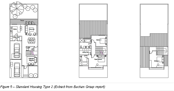
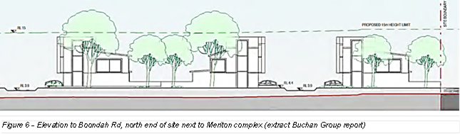
Most, if not all the proposed R3 Medium Density Residential zoned
land (around 90% of total site area) will be subject to earthworks, mostly
filling to raise the land to achieve levels required to meet flood planning
criteria, including townhouse ground levels at RL4.4m, road and driveways at RL3.9m, and
park and play areas at RL2.5m. Boondah Road along the site’s
frontage is also to be raised to RL3.9m - which is 1% AEP (previously referred
to as 1 in 100-year flood level) plus an allowance for climate change. The
earthworks are likely to necessitate removal of most if not all the existing
vegetation in the proposed R3 zoned area. No earthworks are proposed for
the riparian corridor proposed to be zoned C2 Environmental Conservation.
The applicant
has not made an offer to enter into a Planning Agreement. The applicant has stated the intention is for the C2 zoned land to
remain in private ownership as part of a Community Title.
Assessment of Planning Proposal
The following
assessment is set out in accordance with the relevant NSW
Government Local Environmental Plan Making Guideline (Guideline).
Part 1
– Objectives or Intended Outcomes
The stated objectives and
intended outcomes of the Planning Proposal are to:
· continue residential development adjoining existing residential
development within the Warriewood Valley release area
· provide residential accommodation opportunities responding to
identified demand
· optimise the utilisation of existing infrastructure
· preclude from urban development those areas identified through the
studies undertaken that are not suited for urban development
· to accommodate approximately 44 dwellings
equating to a yield of approximately 22 dwellings per hectare.
The stated objectives rely on
the proponent’s stated premise that the Planning Proposal responds to the
outcomes of the previous Rezoning Review for the 2019 Planning Proposal. The
proponent suggests that the SNPP found that the proposed development
potentially had site specific merit but not strategic merit, and that changes
to the 2018 Warriewood Valley Development Contributions Plan (Contributions
Plan) whereby Council is no longer targeting the land for acquisition for open
space resolve a key reason for the 2019 Planning Proposal failing to satisfy
strategic merit.
Response
This premise is not
accepted. Although the quantum of open space still to be delivered in the
Release Area has been revised down and the site is no longer identified in the
Contributions Plan for purchase for future active open space,
this does not mean that the site by default becomes suitable in a strategic
planning sense for urban or residential development.
The site’s earlier
designation for active open space was not based solely on meeting the needs of
the anticipated population, but also on the findings of a suite of technical studies
that informed the planning strategy for Warriewood Valley Release Area. These
studies included land capability mapping based on identified environmental
constraints to development such as flooding, bush fire and biodiversity.
Strategic Merit is discussed further in Part 3 below.
The current zoning remains
strategically appropriate particularly having regard for the constraints of the
site and the commentary from the SES.
Part 2
– Explanation of Provisions
The
applicant’s proposed LEP amendments seek to:
· rezone the site from RU2 Rural Landscape to R3 Medium Density
Residential and C2 Environmental Conservation (see Figures 7 and 8)
· increase the maximum building height from 8.5m to 15m over the
proposed R3 zoned land, or an alternative approach that imposes an RL to AHD
limit based on flood planning level plus 9.5m
· remove the minimum subdivision lot size
· amend the Urban Release Area Map and clause 6.1(3) to apply a
dwelling yield range of 40-45 dwellings.
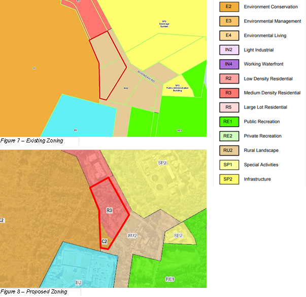
Response – Proposed Zoning
The proposed R3
zoning may be a suitable zoning to accommodate residential development at the
density that is proposed. However, the extent of development proposed is
not appropriate having regard to flooding, biodiversity, and water quality.
These issues are discussed further in Part 3. As discussed above, the
current zoning remains strategically appropriate particularly having regard for
the constraints of the site and the commentary from the SES.
The proposed C2 Environmental zoning is not acceptable, for the
following reasons:
· It has not been demonstrated that the extent of the proposed C2
zoning adequately aligns with the biodiversity values of the land and the
conservation requirements to protect these values.
· While the applicant has stated that the proposed C2 zoning boundary
will encompass all the mapped Coastal Wetland under State Environmental
Planning Policy (Resilience and Hazards) 2021, the Site Plan has not been
revised to reflect this. Although conceptual in nature, the Site Plan and plans
included in a supporting memo by Calibre dated 14 October 2022 show roads,
earthworks, asset protection zones, and indicative locations of bioretention
basins, stormwater filters and discharge points within areas of mapped Coastal
Wetland.
· While the applicant has stated that the
proposed C2 zoned land is intended to remain in private ownership under a
Community Title scheme, without confirmation to indicate otherwise, it is
possible that the C2 zoning could trigger an obligation for Council to acquire
the land under the owner-initiated hardship provisions of the Land Acquisition
(Just Terms Compensation) Act 1991, if the C2 zoning is deemed to be reserving
the land for use for a public purpose. Despite enquiries made by Council
planners, the Department of Planning and Environment (DPE) was unable to
clarify the operation of the relevant legislation in this instance due to legal
complexity. While this remains uncertain, it represents a financial risk for
Council.
· While the proposed C2 zoning may offer better protection of
biodiversity values than the current RU2 Rural Landscape zoning, there is
uncertainty over responsibility
for implementing the proposed conservation measures, and the prospects
of Biodiversity Certification.
If the Planning Proposal were to proceed,
the above issues could be investigated further, and potentially resolved
through suitable detailed information and amendments to the proposal.
Amongst other things, to allay concerns about an acquisition obligation,
Council would need confirmation from the DPE that it
would not require the proposed C2 zoned land to be included on the Land
Reservation Acquisition Map in Pittwater LEP and assurance
from a legal perspective that the proposed C2 zoned land would not be subject
to owner-initiated acquisition provisions of the Land Acquisition (Just Terms
Compensation) Act 1991.
If the Planning Proposal were to proceed,
the precise boundaries of the new zones would need to be determined through
resolution of the relationship of the proposed C2 zone boundary to mapped
Coastal Wetland under SEPP (R&H) and ground-truthing of vegetation and
biodiversity mapping.
Response – Building Height
In response to
concerns about the proposed 15m building height limit, the applicant suggested
an alternative building height limit using a maximum RL
based on flood planning level plus 9.5m.
No ground survey
information has been submitted to indicate the maximum level of fill necessary
to achieve flood planning levels. The onus is on the applicant to satisfy
Council that future buildings would not be excessive in scale or out of
character with the area. Nevertheless, while precise
LEP provisions or maps have not been provided, the applicant has indicated the
intended outcome is for future buildings be limited to two-storeys plus attic
with a maximum height above filled ground levels of 9.5m. This is sufficient
explanation to assist in legal drafting of a suitable LEP amendment if the
Planning Proposal were to proceed. As such, building height is no longer
considered to be a reason to reject the proposal and has been deleted from the
recommendation since reporting to the Local Planning Panel.
Response – Dwelling
Yield Range
Part 6.1 of the
LEP implements the adopted planning strategy for Warriewood Valley Release Area
contained in the Warriewood Valley Strategic Review (WVSR) adopted by former
Pittwater Council and endorsed by NSW Director of Planning in 2013 and the
Warriewood Valley Strategic Review Addendum (WVSR Addendum) adopted in 2014 and
amended in 2017 (WVSR Addendum).
Clause 6.1(3)
of the LEP specifies dwelling yield ranges to control the density of
residential development. The dwelling yield ranges are based on densities
adopted through the WVSR and WVSR Addendum for individual residential sectors,
with density calculated on the ‘developable area’ – that is,
the total site area excluding land identified as environmentally sensitive,
creek line corridor and/or having no potential for development due to a
prevailing condition/hazard.
32 dwellings
per developable hectare is the maximum density that has been planned and
applied generally across most of the undeveloped release land in Warriewood
Valley through the WVSR and WVSR Addendum.
The Planning Proposal seeks a dwelling
yield range of 40-45 dwellings which equates to a density of approximately 22
dwellings/ha. However, this calculation is not appropriate as not all of the
site can reasonably be considered ‘developable’ given significant
environmental constraints associated with flooding and riparian and
biodiversity values, especially in the southern half of the site.
The Water Management Report by Calibre
nominates at page 37 that the ‘developable land’ is a minimum of
1.32ha, defined as the land within the low and medium flood hazard zones.
1.32ha at a density of 32 dwellings per hectare will permit 42 dwellings.
On this basis, the proposed dwelling yield
range is generally consistent with the density limit of 32 dwellings/ha applied
by the planning strategy for Warriewood Valley.
Affordable
Housing
Council’s stated policy is that it is
committed to a 10% affordable rental housing target for all planning proposals
for urban renewal or greenfield development, and the Contributions Scheme and
related LEP provisions are the mechanism by which affordable housing is to be
secured.
The proposed LEP amendments do not include
any amendments to give effect to an affordable housing contribution in
accordance with Council’s Affordable Housing Policy and its Affordable
Housing Contributions Scheme. Such amendments would include a new LEP clause
and map, and a new section in the Contributions Scheme applying to the subject
land, to specify the proportion of total residential gross floor area to be
dedicated as affordable housing or provided as a monetary contribution in lieu
of dedication as a condition of a future development consent.
The Planning Proposal includes an offer to provide four dwellings as
affordable housing for a period of 10 years, managed during that time by a
registered community housing provider. Affordable housing for a time
limited period is not acceptable, nor is it in accordance with Council’s
Policy. Dwellings secured for affordable housing are required to be in
Council ownership in perpetuity.
Part 3 –
Justification
Strategic Merit
Section A – Need for the Planning
Proposal
Q1. Is the planning
proposal a result of an endorsed LSPS, strategic study or report?
The applicant’s report states the
site has been part of the Warriewood Valley Release Area since its inception
and is identified in the WVSR and WVSR Addendum as land having development
capability ranging from Least to More.
The case for need put forward by the
applicant is based on housing need, in particular that the proposal responds to
a shortfall of 275 dwellings identified in Council’s Local Housing
Strategy (LHS), a shortfall of 251 dwellings from the original forecasts for
the Release Area, and the exacerbation of any shortfall resulting from the
abandonment of the Ingleside Place Strategy.
The proposal also relies on the provision
of four dwellings for a period of 10 years as affordable housing which is
stated to maximum opportunities for affordable housing dwellings.
Response
The applicant’s justification with
regards to need is not supported.
The LHS forecasts housing demand to the
year 2036 and identifies a deficit in capacity under the current planning
controls of 275 dwellings across the entire Northern Beaches local government
area. The LHS estimates of capacity to meet housing demand factored in 1000 new
dwellings in Ingleside. In response to the State Government’s
decision last year to not proceed with Ingleside Place Strategy,
Council’s strategic planning team is actively investigating alternative
locations.
The LHS builds on the strategy for housing
identified in Council’s Towards 2040 Local Strategic Planning Statement
(LSPS) of focusing new housing in and around centres with good transport.
Centre Investigation Areas are the cornerstone of Council’s adopted
approach to meeting housing targets and the LHS identifies Brookvale, Dee Why,
Mona Vale, Manly Vale and Narrabeen as priorities for urban renewal in the
short-medium term. Medium density residential development is to be
concentrated in strategic and selected town centres on the current and future
B-line routes, and these centres will be the subject of detailed planning to
identify opportunities for renewal and respond to the unique circumstances and
character of each centre. As discussed further under Q.4 below, Warriewood was
not identified as a viable option for a Centre Investigation Area in the LHS.
Planning for Brookvale to deliver on
housing targets is well advanced. Brookvale strategic centre has potential to
meet the 275 dwellings deficit identified in the LHS and a major portion of the
1000 dwellings no longer being planned in Ingleside, in a location having
significant advantages in terms of existing infrastructure, proximity to
employment and services, and an efficient, transit-supportive urban structure
that can promote less reliance on private vehicles and less impact on traffic
congestion. Forward planning for growth and development in Brookvale
began in 2016 and a revised Draft Structure Plan was endorsed by Council in
November 2022 and is undergoing a final phase of public exhibition until 28
February 2023. The plan envisages an additional 1300 apartment-style dwellings
in and around Brookvale centre, which will add to housing diversity.
Given the progress made to date and the
ability for Council to meet its housing targets through a methodical,
strategic, principles-based approach to increasing housing capacity in and
around its most accessible centres, there is no need for the subject Planning
Proposal to rezone land in Warriewood, especially given the site-specific
constraints and potential environmental, social, and economic impacts which are
discussed in the section on Site-Specific Merit later in this report.
Q2. Is the planning
proposal the best means of achieving the objectives or intended outcomes, or is
there a better way?
The applicant’s report suggests the
site is a logical extension of existing urban zoned lands and the Planning
Proposal is a logical infill development opportunity that does not face the
infrastructure delivery constraints that pose challenges to the Ingleside and
Frenchs Forest release areas.
Response
As discussed
under Q1. above, Council is on track to meet the housing targets identified in
its’ LHS and detailed planning is underway for Centre Investigation Areas,
including Brookvale. Phase 1 of the Frenchs Forest Precinct is being
implemented through new planning controls that came into effect on 1 June 2022
and is scaled to ensure growth and development is in line with infrastructure.
The subject
site faces other challenges that Frenchs Forest and Brookvale are not so
affected by, for example flooding, bushfire and biodiversity. There are better
ways to achieve the objectives or intended outcomes, as discussed further
below.
Section B
– Relationship to strategic planning framework
Q3. Will the planning proposal give effect to the
objectives and actions of the applicable regional, or district plan or
strategy?
The applicant’s report states
that the Planning Proposal is consistent with Greater Sydney Region Plan and
North District Plan.
Response
The proposed development involves
significant issues associated with flood risk and the SES has raised
significant concerns. Shelter in place is not an acceptable strategy to manage
flood risk for future development of housing on land not currently zoned for
housing. The proposed development will result in unacceptable impacts on
biodiversity, fails to provide an adequate buffer to adjacent wetland, and
insufficient information has been submitted in relation to water quality
management and impacts on groundwater dependent ecosystems. For these reasons,
the Planning Proposal is inconsistent with:
Greater Sydney Region Plan
· Objective 27: Biodiversity is protected, urban bushland and remnant
vegetation is enhanced
· Objective 36: People and places adapt to climate change and future
shocks and stresses
· Objective 37: Exposure to natural and urban hazards is reduced.
North District Plan:
· Planning Priority N16: Protecting and enhancing bushland and
biodiversity
· Planning Priority N22: Adapting to the impacts of urban and natural
hazards and climate change
Q4. Is the planning proposal consistent with a council
LSPS that has been endorsed by the Planning Secretary or GSC, or another
endorsed local strategy or strategic plan?
The applicant’s report states that the Planning
Proposal is consistent with the endorsed LSPS and the endorsed LHS.
Response -
Towards 2040 Local Strategic Planning Statement
The proposed
development involves significant issues associated with flood risk and the SES
has raised significant concerns. Shelter in place is not an acceptable strategy
to manage flood risk for future development of housing on land not currently
zoned for housing. The proposed development will result in unacceptable impacts
on biodiversity, fails to provide an adequate buffer to adjacent wetland, and
insufficient information has been submitted in relation to water quality
management and impacts on groundwater dependent ecosystems.
With good progress made to date and the
ability for Council to meet its housing targets through a methodical,
principles-based approach to increasing housing capacity and diversity in and
around its most accessible centres, there is no need to rezone the subject site
to allow housing, especially given the flooding constraints and potential
environmental impacts.
The proposal fails to incorporate
appropriate provision for contributing affordable housing dwellings in
perpetuity in accordance with the relevant policy and scheme.
The proposed C2 zoned land presents
uncertainty for Council with regards to potential acquisition triggers and
responsibility for ongoing implementation of conservation measures.
For these reasons, the Planning Proposal is
inconsistent with the following Priorities of the LSPS:
· Priority 1: Healthy and valued coast and waterways
· Priority 2: Protected and enhanced bushland and biodiversity
· Priority 8: Adapted to the impacts of natural and urban hazards and
climate change
· Priority 15: Housing supply, choice and affordability in the right
locations
· Priority 16: Access to quality social and affordable housing
It is furthermore inconsistent with the
following Housing Principle adopted in the LSPS:
· Limit development where there are unacceptable risks from natural
and urban hazards, or impact on tree canopy.
Response –
Northern Beaches Local Housing Strategy
Council’s
ongoing forward planning for centres will address the shortfall of 275
dwellings identified in the LHS and find alternatives for the 1000 dwellings
previously envisaged for Ingleside.
The Centre Investigation Areas earmarked in
the LHS for investigation for renewal will be the key locations
for delivering new housing with detailed planning for these centres looking to
provide a variety of housing types including medium to
higher density housing in highly accessible locations.
The second approach outlined in the LHS,
Low-rise Housing Diversity Areas, identifies Warriewood as one of several local
centres potentially suited to low to medium density typologies within 400m of
centres. This approach is explicitly subject to environmental and other
constraints, which means the site’s flooding, bushfire and biodiversity
constraints would need to be properly considered and addressed.
Warriewood’s disjointed layout, with
the shopping centre being more than 350m from the B-line stop, does not lend
itself to a decision on balance where the benefits of providing more housing
would outweigh the disbenefits associated with flood risk and impacts on
biodiversity.
These issues with the location of the
B-line stop, the layout of the wider centre, and the local environmental and
flooding constraints, are the reason Warriewood did not present as a viable
option for a Centre Investigation Area in the LHS.
As the Planning Proposal does not
adequately address the site’s environmental constraints, it is
inconsistent with the LHS.
Warriewood Valley Strategic Review and Warriewood
Valley Strategic Review Addendum
Assessment of Strategic Merit
should also consider the adopted planning strategy for
Warriewood Valley Release Area contained in the Warriewood Valley Strategic
Review Report adopted by the former Pittwater Council and endorsed by the NSW
Director of Planning in 2013 (WVSR) and the Warriewood Valley Strategic Review
Addendum Report adopted in 2014 and amended in 2017 (WVSR Addendum).
Clause 6.1(3) of the LEP, which implements the planning strategy for Warriewood
Valley Release Area, includes the objectives:
(a) to permit
development in the Warriewood Valley Release Area in accordance with
the Warriewood Valley Strategic Review Report and the Warriewood
Valley Strategic Review Addendum Report, and
(b) to
ensure that development in that area does not adversely impact on waterways and
creek line corridors, protects existing native riparian vegetation and
rehabilitates the creek line corridors.
The catalyst for WVSR was an approval in 2011 by the
Planning Assessment Commission (PAC), under its now repealed Part 3A powers, of
the Meriton development at the corner of Macpherson Street and Boondah Road,
comprising multiple 3-4 storey residential flat buildings with a total of
approximately 450 dwellings. Part of this development adjoins the subject
site’s northern boundary. The PAC called for a comprehensive strategic
study for all undeveloped land in Warriewood Valley, including for the first
time the Southern Buffer area, which includes the subject site.
The WVSR investigated the
remaining undeveloped lands, first utilising composite land capability mapping
of a range of environmental, economic, and social characteristics to classify
land into categories of capability for development ranging from Least to Most
developable. It then drew on a major hydrology study to inform developable land
classifications, and used independent urban design, strategic transport, and
economic feasibility studies to determine the recommended density and dwelling
yield ranges for specific residential sectors. These were incorporated into the
controls in clause 6.1 of the LEP, and such provisions required endorsement by
the State Government.
The WVSR explored development
opportunities for the Southern Buffer, including the potential for a mixed-use centre.
It recognised that under existing conditions, flood depths exceed 1m
across most of the Southern Buffer in a 1% AEP event and that a significant
amount of compensatory cut and fill would be required to create two developable
areas; one being 0.87ha at the northern end of the Southern Buffer (i.e., part
of 10 Boondah Road), the other at the corner of Pittwater and Jacksons Rds. It
also recognised the high biodiversity values of some of the Southern Buffer
land. Although a draft concept plan and design principles were publicly
exhibited, due to community opposition and a reluctance amongst landowners to
collaborate, the concept did not progress any further. No future land use or
dwelling yield was recommended for the Southern Buffer.
The WVSR Addendum was prepared to identify
a forward path for remaining sectors which were not considered or not
identified with a forward path by the WVSR. The WVSR Addendum utilised updated
information on bushfire, flooding, biodiversity, and slope to produce new land
capability mapping. It re-evaluated sector boundaries and recommended
dwelling densities with dwelling yield ranges that were once again incorporated
into subsequent amendments to LEP clause 6.1.
The WVSR Addendum was also informed by the
Pittwater Open Space and Recreation Strategy in 2014, which highlighted a
significant undersupply of active recreation areas in the Pittwater LGA and the
importance of Release Areas providing places and facilities for recreation to meet the needs of their incoming populations. The estimated
remaining open space to be provided in Warriewood Valley Release Area was
identified as 6.32ha, comprising 1.69ha of linear open space and 4.63ha of
active open space.
For the Southern Buffer, based on updated
flood and bushfire information, biodiversity values, and the findings of the
Open Space and Recreation Strategy, no residential potential was
identified. Most of the Southern Buffer, including the subject site was
given a land use designation of ‘Active Recreation’. This
outcome is reflected in the absence of any Southern Buffer land from the table
in Clause 6.1(3) of the LEP which specifies the number of dwellings to be
erected on specified land areas in the Release Area. It was also later
reflected in the Warriewood Valley Development Contributions Plan which
specifically identified 5 properties along Boondah Road, including the subject
site, for purchase for active open space.
Following years of unsuccessful attempts to
purchase this land, revisions to the Contributions Plan which came into effect
on 1 July 2022 reflect a change in strategy to focus on embellishment of
existing sports fields instead of purchasing of additional land to meet the
needs of the population for active open space. While the subject site
is no longer identified for purchase for active open space,
this does not mean that site by default becomes suitable in a strategic
planning sense for residential development. The planning strategy for
Warriewood Valley set out in the WVSR and the WVSR Addendum was informed by
land capability mapping and a suite of technical studies that recognised
constraints to development such as flooding, bush fire and biodiversity. The
site has never been allocated an endorsed forward path for residential
development because of these characteristics. Any Planning Proposal to enable
residential development would need to demonstrate that these characteristics
can be properly managed through a design and impact assessment process that
achieves a site that is suitable for the intended uses, without significant
adverse economic, social, or environmental impact. This has not been
demonstrated in this case.
Q5. Is the planning proposal consistent with any other
applicable State and regional studies or strategies?
See earlier comments under Question 3.
Q6. Is the planning proposal consistent with applicable
SEPPs?
The
applicant’s report states that the Planning Proposal does not conflict
with any of the SEPPs.
Response - SEPP
(Resilience and Hazards)
In relation to Chapter 2 Coastal Management
of the SEPP (R&H), the site is mapped as Coastal Wetlands and Proximity
Area for Coastal Wetlands (see Figure 9).
In accordance
with Part 2.2 of the SEPP (R&H), Council must not grant consent for
development unless it is satisfied that:
· for Coastal Wetlands, “sufficient measures have
been, or will be, taken to protect, and where possible enhance, the
biophysical, hydrological and ecological integrity of the coastal wetland or
littoral rainforest”; and
· for
Proximity Areas, “the proposed development will not significantly
impact on -
(a) the
biophysical, hydrological or ecological integrity of the adjacent coastal
wetland or littoral rainforest, or
(b) the quantity
and quality of surface and ground water flows to and from the adjacent coastal
wetland…”
The Planning
Proposal has not demonstrated that a future development application will be
able to satisfy Council in accordance with these requirements.
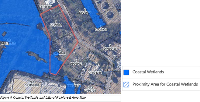
Part of the mapped Coastal Wetland falls
within the proposed R3 zoned area that is intended to be developed, including
areas subject to proposed earthworks, roads, parking, bioretention basins,
stormwater filters and outlets, and management as a bushfire APZ. Wetland
vegetation will necessarily be removed and altered stormwater flow regimes
could have detrimental impacts on groundwater dependent ecosystems both within
the site and the adjacent Warriewood Wetlands.
All of the site that is mapped Proximity
Area will be subject to major earthworks to raise the land above flood planning
levels which will significantly alter flows to and from the site. The applicant
has not submitted information regarding the potential impact of the altered
flow regimes on the Wetland or undertaken adequate groundwater investigation
and water quality monitoring.
The Planning Proposal fails to provide a
15m wide extensively landscaped buffer to protect the adjacent wetlands in
accordance with clause 6.6 of the Pittwater DCP (DCP) due to management
requirements of the overlapping bushfire Asset Protection Zone (APZ). In order
to function as an effective ecological buffer to the wetland, the DCP requires
a 15m buffer consisting of landscaped mounds with mass planting of native trees
and shrubs. The buffer should be exclusive of any APZ, and not overlap with it
as is proposed. This is consistent with conditions of approval set by the PAC
for the adjacent Meriton development, requiring a 25m wide APZ outside of a 10m
wide Vegetated Wetland Buffer Zone and no excavation works in the Wetland
Buffer Zone.
The Planning Proposal does not take
adequate measures to protect or enhance the hydrological and ecological
integrity of the mapped Coastal Wetland or to minimise impact on the
quantity and quality of surface and ground water flows to and from the adjacent
Coastal Wetland.
Furthermore, any development within the
mapped Coastal Wetland area would be Designated Development requiring an
Environmental Impact Statement under the SEPP (R&H) provisions.
Having regard for deficiencies associated
with the proponent’s Strategic Bushfire Study, as discussed further under
Q.7 below, concern exists in relation to the ability for a future development
application to satisfy section 4.14 of the Environmental Planning and
Assessment Act 1979.
Q7. Is the planning
proposal consistent with applicable Ministerial Directions (s.9.1 directions)?
The applicant’s report states the Planning Proposal would be consistent with all
relevant Directions.
Response - Local
Planning Direction 4.1 Flooding
The Planning Proposal is not consistent
with clause 4.1(2) of Direction 4.1 as it seeks to rezone land within the flood
planning area from a Rural zone to a Residential zone.
The Planning
Proposal is not consistent with clause 4.1(3) of Direction 4.1 as it will:
· permit development that will result in significant flood impacts to
other properties,
· permit a significant increase in the development and/or dwelling
density of that land; and
· is likely to result in a significantly increased requirement
for government spending on emergency management services, flood mitigation and
emergency response measures.
Direction 4.1 requires planning proposals
to give effect to and be consistent with the principles of the Floodplain
Development Manual 2005 (the Manual), any flood study prepared by Council in
accordance with the Manual, and the Considering Flooding in Land Use Planning
Guidelines which introduced Standard Instrument LEP clauses related to
Flooding.
The Manual promotes a merit approach to
development decisions in the floodplain, taking into account social, economic,
and ecological factors as well as flooding considerations. Its primary
objective is to reduce the impact of private and public losses resulting from
floods, and it looks to containing the potential for flood losses through
application of planning and development controls and enabling councils to be
responsible for determining the appropriate planning and development controls
to manage future flood risk.
The Pittwater Development Control Plan
(DCP) includes flood-related controls in section B3.11 Flood Prone Land.
For land affected by flooding in High and Medium Risk Flood Precincts, the
controls require that development must demonstrate, amongst other things, for
all flood events up to the 1% AEP event: no adverse impacts on flood levels or
velocities caused by alterations to the flood conveyance, no adverse impacts on
surrounding properties, and no net loss of flood storage.
The Planning Proposal involves filling of
most of the proposed R3 zoned land and the amount of fill is substantial to
achieve flood planning levels for the townhouses of RL4.4m, well above existing
ground levels of around 2-4m AHD. Without compensatory cut, this will result in
a sizeable net loss of flood storage from the site which will need to be
absorbed by other properties in the floodplain. The proponent has not
demonstrated no net loss of flood storage. No volumetric calculations
indicating the balance of cut and fill have been provided. The proponent has
instead focused on modelling to demonstrate no adverse impacts on surrounding
properties and compliance with specific DCP controls for Warriewood Valley
Release Area under C6.1.
Development that results in a net loss of
flood storage is contrary to specific controls established by Council to manage
flood risk.
Cumulative
loss of floodplain storage is an important consideration, particularly where land is not
currently zoned for the type and intensity of development proposed. Any net
loss of flood storage from the site, as a result of filling to achieve adequate
levels for new houses and roads, requires other properties to absorb the
storage lost. Flood levels and flows can increase on other properties and the
combined, cumulative effects may be excessive if other sites in the catchment
are similarly rezoned and filled for housing following any precedent set by
this Planning Proposal.
Risks to life and property are critical
considerations under Direction 4.1.
The results of Calibre’s flood
modelling of the Probable Maximum Flood (PMF) event indicate that at 195
minutes into a PMF storm event, internal driveways and Boondah Road become
unsafe for small vehicles, and at 210 minutes into a PMF storm event water
levels on the site have risen to 4.54m and will enter the ground floors of the
townhouses, and anyone who has not evacuated will need to shelter in place on
the first floor above. The applicant proposes a private evacuation alarm system
(light and siren) set to trigger at a flood level 90 minutes into the PMF storm
event allowing 75 minutes for people to pack and leave, and another sensor set
to trigger at 180 minutes (different light and siren) indicating it is too late
to leave and residents must shelter in place.
Evacuation will add pressure on a road
system that is restricted in major flood events, and the efficacy of a private
alarm system is questionable in terms of who maintains it in working order and
how future residents will understand and respond to alarms when activated.
The NSW State Emergency Service (SES) provided advice (Attachment 2)
on the Planning Proposal. The SES advice refers to the Ministerial Direction
for Flooding and the NSW Floodplain Development Manual and identifies the
following issues with Planning Proposal:
· zoning should not enable development that will result in an increase
in risk to life, health or property of people living on the floodplain
· warning technology cannot be relied on to guarantee a faster
response from the community and any advantage gained by the application of
warning technology should be considered as a safety factor, not a potential for
increasing development
· evacuation must not require people to drive or walk through flood
water
· development strategies relying on deliberate isolation or sheltering
in buildings surrounded by flood water are not equivalent, in risk management
terms, to evacuation
· shelter in place is not a flood management strategy endorsed by the
SES for future development, such an approach is only suitable to allow existing
dwellings that are currently at risk to reduce their risk, without increasing
the number of people subject to such risk
· SES is opposed to imposition of development consent conditions
requiring private flood evacuation plans rather than application of sound land
use planning and risk management
· SES is opposed to development strategies that transfer residual
risk, in terms of emergency response activities, to the SES and/or increase
capability requirements of the SES
· consent authorities should consider the cumulative impacts any
development will have on risk to life and the existing and future community and
emergency service resources.
The views of the SES, as the lead
agency in NSW for planning for, responding to, and coordinating recovery from
floods, should be paramount in land use decisions for flood-prone land. The
agency has expressed a view that it does not support future development (i.e.
new residential development enabled by rezoning) on flood prone land where
early evacuation, private alarm systems and shelter in place strategies are
necessary to manage flood risk. In other words, the Council should not support
rezonings which place new communities in locations that expose people and
property to risks associated with major floods and increase the potential
burden on emergency services.
The proponent submitted a memorandum by
Calibre dated 16 September 2022 in response to issues raised by the SES in its
preliminary advice. Upon review of this further information, the SES advised it
does not have any further comment.
The proponent further submitted a letter by
SJB Planning dated 20 December 2022 and a letter by Calibre dated 20 December
2022, in which points were raised about the consistency of the flood risk
assessment and evacuation requirements of the proposal with DPE’s Flood
Risk Management Manual and associated Flood Risk Management Guide EM01 (Guide
EM01) published in February 2022, in particular the flow charts for rezoning
and greenfield developments.
The SES confirmed that Guide EM01 is a
draft, and the proposal has not satisfied the conditions outlined in Guide
EM01, in particular:
· Noting that Boondah Road will be raised to the level of 1% AEP plus
climate change, this area will still be a Low Flood Island. Low Flood Islands
represent the highest risk to life.
· The proposed development does not have sufficient time to
evacuate.
· The proposed modifications do not address the evacuation
constraints.
· The flood evacuation constraints in an area should not be used as a
reason to justify new development by requiring the new development to have a
suitable refuge above the PMF. Allowing such development will increase
the number of people exposed to the effects of flooding.
Since the release in draft of the abovementioned
Guide EM01, catastrophic floods have occurred in NSW, and it is understood that
the Department of Planning and Environment is giving further thought to the
ways in which natural hazards can be better managed early in the strategic
planning process.
The NSW government has explicitly
recognised the important role of the planning system in supporting resilience
in places and communities, and its’ commitment to continuous improvement
to the planning system to create greater resilience to chronic stresses and
episodic shocks such as floods and bushfires.
Effective planning can and should reduce
exposure to natural hazards. The Planning Proposal is fundamentally contrary to
planning for resilience, as it will increase the number of people exposed to
flood risk on the Northern Beaches.
Council’s Floodplain Planning unit
does not support the Planning Proposal and has indicated the proposal is not
compliant with Local Planning Direction 4.1, identifying the following issues:
· the applicant has not demonstrated that the proposed development
will not result in significant adverse impacts to other properties.
· land filling to raise the roads and building platforms appears to
result in a net loss of flood storage in the mainstream flood lagoon floodplain.
· no volumetric figures showing the cut and fill balance have been
provided.
· Council must be satisfied that the proposed development will convey
water and have the same flood storage function as existing.
· it is not appropriate for Council to support future development (via
rezoning) that uses shelter in place as a management strategy that will
increase the flood risk and the number of people exposed to flooding.
· the applicant has not demonstrated that the proposed development
will not result in a significantly increase requirement for government spending
on emergency management services, flood mitigation or emergency response
measures.
Council’s
Floodplain Planning unit also identified inconsistencies with:
· principles of the NSW Floodplain Development Manual 2005
· the Australian Disaster Resilience Handbook Collection
· Pittwater LEP Clause 5.21 Flood Planning
Given the level
of filling proposed, loss of flood storage, exposure of people and property to
flood risk, and the reliance on a shelter in place strategy with a private
alarm system, the Planning Proposal is inconsistent with Pittwater Local
Environmental Plan (LEP) clause 5.21 in that it will:
· result in significant adverse impacts to other properties or adverse
cumulative impacts on flood behaviour in a way that results in detrimental
increases in the potential flood affectation of other properties;
· adversely affect the safe occupation and efficient evacuation of
people; and
· place people and property at risk or in intolerable conditions in
the event of a major flood.
With regards to assessing flood risk
for this proposal, Council’s floodplain engineers have advised:
· when assessing flood risk,
Council considers the full range of flood events up to the PMF
· during a PMF event, the roads
will be cut off and evacuation will not be possible
· for events larger than 1%
AEP + CC and up to the PMF event the proposal relies on shelter in place as the
strategy to manage flood risk
· the DCP does allow for
shelter in place when flood free evacuation during a PMF event is not possible,
however as this is a rezoning application and not a development application,
Council needs to consider SES’s concerns and other relevant policies and
guidelines. Shelter in place is generally only suitable for existing dwellings
that are currently at risk to reduce their risk.
The imperative
for Council to carefully consider the risks associated with development on
flood prone land has increased markedly in recent years on account of extreme
weather and flood events on the Northern Beaches and elsewhere in NSW and
Queensland. On 28 June 2022, Council adopted the Northern Beaches Resilience
Strategy, with a key priority and associated action being:
Priority
1. Avoid intensification of development, inappropriate development
and incompatible land uses in areas exposed to natural and urban hazards.
Action 1a. Establish planning controls
that limit intensification, inappropriate development and incompatible land
uses to reduce or avoid risks from natural hazards.
This is a
logical shift in policy toward a more considered and cautious approach to
managing the risk posed by natural hazards, particularly in the context of
climate change.
Response -
Local Planning Direction 4.3 Planning for Bushfire Protection (Direction 4.3)
The referral
response from Council’s Bush Fire Management Coordinator highlights the
following deficiencies in the Strategic Bush Fire Study submitted with the
Planning Proposal:
· “There
is minimal consideration of the likelihood of a bush fire impacting the site
and its potential severity on a landscape scale.
· The
study relies on site specific protection measures rather than assessing the
appropriateness of the proposal in the context of the surrounding landscape.
· The
suitability of the proposal on the landscape should have stronger logical
connections to informing the siting and layout of the proposed development.
· There
is no assessment on the capacity of the road network either internally or
externally to sufficiently handle evacuating residents and responding emergency
services to/from the proposal; nor identification of evacuation routes or
assessment of the potential for the development to become isolated during a
fire event.
· There
is no assessment of the development impact on the provision or capacity of
emergency services, other than minor references to the proximity of surrounding
fire stations.
· There
is no assessment of the provision of infrastructure services to the proposal as
the study suggests that this should be the subject of a separate study.
· There
is limited assessment of the impact of the proposal on neighbouring lands, and
no consideration for managed lands to the south of the proposal to remain such
in perpetuity.
· Site
specific APZs are not contained within the development relying on adjoining
road verges. Should any land with the proposal be vested to Council, Council
may be burdened with the ongoing APZ management of these and/or adjoining road
verges.
· The
study indicates that perimeter roads within the proposal rely on a performance
solution. Performance solutions should be accompanied with the appropriate Bush
Fire Design Brief and/or Bush Fire Management Plan which has not been supplied.”
If the Planning Proposal proceeds through
Gateway Determination, it will be formally referred to the Rural Fire Service
for comment.
Site-Specific Merit
Section C – Environmental, social,
and economic impact
Q8. Is there any likelihood that critical habitat or
threatened species, populations or ecological communities, or their habitats,
will be adversely affected because of the proposal?
The
Applicant’s report states that the Biodiversity Certification process
will manage the potential impacts on identified threatened species, habitat,
ecological communities, and that the masterplan for the proposal has been
guided by the site’s ecological constraints and bush fire management
requirements with the perimeter road network providing a managed edge to the
ecological values of the adjacent Wetland and a defendable perimeter for the
development.
Response
The site contains significant biodiversity
values including Threatened Ecological Communities, mapped Coastal Wetland and
Proximity Area for Coastal Wetland, records of threatened species, threatened
species habitats and fauna connectivity.
Areas along the site’s western
boundary and the south-western corner of the site are mapped on the Department
of Planning and Environment’s Biodiversity Values map which identifies
land with high biodiversity value that is particularly sensitive to impacts
from development and clearing. The mapping is part of the Biodiversity Offsets
Scheme (BOS) thresholds and any vegetation clearing as part of future
development will trigger entry into the BOS. The applicant has made application
for BioCertification to the State Government and the Biodiversity Certification
Assessment Report and accompanying Conservation and Vegetation Management Plans
have been formally submitted to Council for comment.
The two
identified Endangered Ecological Communities (EEC) on the site are:
· Bangalay Sand Forest
· Swamp Oak Floodplain Forest
The six
identified threatened fauna species are:
· Grey-headed
Flying-fox (Pteropus poliocephalus)
· Large
Bent-winged Bat (Miniopterus orianae oceanensis)
· Eastern
Cave Bat (Vespadelus troughtoni)
· Southern
Myotis (Myotis macropus)
· Little
Bent-winged Bat (Miniopterus australis)
· Powerful
Owl (Ninox strenua).
Earthworks and clearing for the proposed
development will directly impact all the Bangalay Sand Forest which covers
around 0.23ha and is entirely within the proposed R3 zone residential
area. The complete removal of this vegetation represents the loss of
approximately 50% of the mapped extent of this EEC on the Northern Beaches.
Nine hollow-bearing trees, some with hollows suitable for the recorded Southern
Myotis will be removed. Whilst this vegetation is degraded, intact mature
canopy remains. The layout of the proposed development fails to avoid or
minimise impacts to this EEC. The BioCertification application recommends retirement
of biodiversity credits or more likely payment into the State
Government’s Biodiversity Conservation Fund to offset the impact.
The Swamp Oak Floodplain Forest (SOFF) covers 0.44ha of the
site and 0.18ha would be directly impacted by the proposed development.
The remainder is located within the portion of the site proposed to be zoned C2
Environmental Conservation.
The six recorded threatened fauna species and their habitats
will be significantly impacted and clearing will remove existing wildlife
corridors through the site between core habitats in Warriewood Wetlands to the
west and corridors along Narrabeen Creek to the east of the site.
In addition to the direct removal of vegetation, altered
surface and groundwater flow regimes have potential to adversely impact ground
water dependent ecosystems on the site and in the wetland.
Other potential impacts relate to ‘edge effects’
to the wetland and remaining SOFF associated with maintaining a 24m wide
Bushfire APZ along the site’s western boundary. The required 15m wide
extensively landscaped buffer to the wetland should be outside of the APZ.
The referral
response from Council’s Biodiversity and Planning unit states:
“…the
Planning Proposal is not supported for the following reasons:
· Lack of measures to avoid and minimise impacts to threatened
biodiversity, including the complete removal of Bangalay Sand Forest. It is
noted that the BCAR states that the proposal will lead to the avoidance of the
majority of mapped biodiversity values within the subject lots, however this is
not correct as the full extent of BSF on site will be directly impacted, as
well as impacts to six threatened fauna species and other native flora and
fauna species.
· Regardless of the reduced development footprint, it appears that the
development within the proposed R3 zone intersects the BV map / Coastal Wetland
and as such, the current concept proposal for 10 & 12 Boondah Road would
require an EIS.
· The current design is not sited and designed to avoid and minimise
impacts to biodiversity. The proposal would result in a direct net loss of
biodiversity. Potential impacts that would result from the proposal include
locating dwellings, associated infrastructure, excavation and filling, and APZs
within the mapped coastal wetland. Further impacts to biodiversity include the
clearing of native vegetation and endangered ecological communities, impacts to
threatened species habitats, reduction in local wildlife connectivity, indirect
impacts associated within increased light and noise pollution, and impacts to
ground water dependent ecosystems within the site and adjoining Warriewood
wetlands.
· The requirement for the retention and enhancement of an ecological
buffer to protect the mapped coastal wetland on site and to the adjoining
Warriewood Wetlands needs amendment to achieve a suitable biodiversity outcome
and reduce potential impacts to the adjoining wetland;
· The lack of a 15 metre wide extensively landscaped buffer strip
adjoining Warriewood Wetlands, exclusive of bushfire asset protection zone, and
consisting of landscaped mounds with mass plantings of native trees and shrubs,
locally indigenous canopy trees with native shrubs, locally indigenous canopy
trees with native shrubs and groundcovers as required by the P21 DCP control
6.6 Landscape treatment of the Buffer Strip. …
· Flooding, flood storage and water flows are of concern, and the
areas of significant vegetation (trees), fauna habitats and wetland buffers
should be retained must not be subject to any excavation / filling.
· The removal of wildlife corridors through and surrounding the site
including direct connection to core habitats within Warriewood Wetlands, as
well as connections to the east that form part of a wildlife corridor that
extends further north along the Narrabeen Creek catchment. It is recommended
that a corridor is provided in the northern boundary of the site, thereby
retaining, enhancing and protecting areas of the TEC BSF.
· Potential for indirect and prescribed impacts to TECs, threatened
species and their habitats
· Likelihood of altered surface and groundwater flow regimes, and
therefore potential direct and indirect impacts to Groundwater Dependent
Ecosystems (GDE) on the subject site and in the locality.
· A reliance within the BCAR that an appropriate storm water
management plan will be prepared to avoid impacts on the TEC, and is not
expected to impact on groundwater resources or groundwater dependent
ecosystems.
Therefore,
the range of issues described above, as well as the loss of native tree canopy,
will result in a future development that does not satisfy the applicable
planning controls, and is not supported by Council’s Biodiversity
Planning section.
In addition,
the offset obligations calculated as part of the Biodiversity Certification
Assessment Report for the TECs and threatened species are not available on the
Northern Beaches, and therefore will result in net loss of biodiversity within
the Northern Beaches LGA.”
Council’s Catchments unit also raised
concerns in relation to impacts on groundwater dependent ecosystems, earthworks
in the buffer to the wetland, and the need for water quality monitoring and
further groundwater and hydrological investigations to demonstrate that impacts on the downstream
environment and the wetland can be suitably managed. The Catchments unit does
not support the Planning Proposal as it is not in accordance with Local Planning Direction 4.2 Coastal Management or SEPP
(Resilience and Hazards) 2021.
Q9. Are
there any other likely environmental effects as a result of the planning
proposal and how are they proposed to be managed?
The proponent’s report identifies potential impacts associated
with flood and bushfire hazard, acid sulphate soils and contamination, and
makes reference to various aspects of the design and layout of the proposed
development and studies undertaken for the Planning Proposal as evidence that
these potential impacts can be minimised and are within acceptable levels.
Response
As discussed earlier, in relation to flood
hazard, the SES has raised significant concerns and does not support shelter in
place or private alarm systems as a strategy to manage flood risk for future
development on land not currently zoned for housing. Extensive
filling of the site to achieve flood planning levels will result in net loss of
flood storage in the floodplain and insufficient information has been provided
to demonstrate that the proposed development will not result in adverse impacts
to other properties, place people and property at risk or in intolerable
conditions in the event of a major flood, adversely affect the safe occupation
and efficient evacuation of people, or significantly increase the requirement
for government spending on emergency management, flood mitigation and emergency
response measures.
As discussed earlier, in relation to
bushfire hazard, Council’s Bush Fire Management Coordinator has
identified deficiencies in the Strategic Bush Fire Study submitted by the
proponent.
The applicant’s submissions in
relation to acid sulphate soils and contamination are accepted.
Q10. Has the
planning proposal adequately addressed any social and economic effects?
The
applicant’s report describes the proposed affordable housing, traffic
impact assessment and access road network, and provision of open space with a
playground and pedestrian link between Boondah Road and Warriewood Wetlands in
relation to addressing social and economic effects.
Response
As discussed earlier, the Planning
Proposal fails to include a suitable mechanism to give
effect to an affordable housing contribution in
accordance with Council’s Policy and Contributions Scheme. These
documents contemplate that dwellings secured for affordable housing are meant
to come into Council ownership in perpetuity. Any residential uplift will
require 10% of the dwellings to be affordable housing stock transferred into
Council ownership. Amendments to Council’s Affordable Housing
Scheme and to Pittwater LEP to secure this contribution would need to be made
in conjunction with a Planning Proposal being progressed to Gateway
Determination, and eventually published as part of the rezoning.
Council’s Transport Network Manager
has provided a referral response on the Planning Proposal which indicates that
the road design is acceptable subject to certain requirements which can be
resolved at the more detailed application stage. Although the impact on
the local road network is acceptable, the applicant is still required to
provide confirmation that the modelling requirements of the RMS (now Transport
for NSW) have been met, particularly with regards to potential impacts on the
intersections of Mona Vale Road/ Pittwater Road and Pittwater Road/Warriewood
Road. If the Planning Proposal proceeds through Gateway Determination, it will
be formally referred to Transport for NSW for comment.
The proposed open space area including the
playground will provide for the recreation needs of the new resident
population. The playground and open space would form part of a community title
and be constructed and maintained by the landholders. The playground and open
space are not suitable for Council ownership as a park asset.
The proposed pedestrian pathway connection
between Boondah Road and Warriewood Wetlands would be required to be
constructed by the developer and dedicated to Council to ensure public access.
The location of the pathway through the southern end of the site is potentially
acceptable, however it should be separate to the internal road network and not
cross any internal roads.
There are potential economic effects
associated with the proposed C2 zoned land. While the
applicant has stated that the proposed C2 zoned land is intended to remain in
private ownership, without confirmation to indicate otherwise, there is a
possibility that the C2 zoning could trigger acquisition
and there is no funding mechanism for Council to purchase the land.
There is also no certainty as to who will
be responsible for any ongoing supervision and/or maintenance of this
land, or bushfire APZs and the buffer to the wetland, and it may be a further
economic burden placed upon the Council.
Additionally, as discussed earlier in relation to flood
hazard, the proposed flood responses are insufficient and transfer residual
risk in terms of emergency response to the SES, thereby increasing demands on
SES resourcing and capabilities and potentially increasing risk to life, health
and property for both existing and future communities.
Section D – Infrastructure (Local,
State and Commonwealth)
Q11. Is there adequate public
infrastructure for the planning proposal?
The referral
response from Council’s Infrastructure unit identifies the following
local infrastructure requirements if a rezoning to permit an additional 45
dwellings on the site were to proceed:
· Reconstruction of Boondah Road
The applicant’s report acknowledges
the requirement for raising of Boondah Road to the level of 1% AED plus climate
change. If the Planning Proposal is to proceed, the full width of Boondah
Road for the entire length of the site’s frontage would need to be
constructed up to the level required for flood evacuation (1% AED plus climate
change) including suitable transitions to the existing carriageway alignments.
· Payment of development contributions towards open space
infrastructure and community facilities in accordance with the applicable
Development Contributions Plan.
An additional 45 dwellings will represent
around 120 additional residents, or an increase of around 2.2% in the total
population forecast for Warriewood Valley. Council’s Parks unit has
advised that this will place additional pressure on active recreation
facilities, but in and of itself does not justify further augmentation of
existing facilities in Warriewood Valley or the acquisition of additional ones.
The approved design of a new community
facility in Warriewood Valley will once constructed provide sufficient
floorspace to accommodate the additional resident population if the Planning
Proposal were to proceed.
Section E - State and Commonwealth
interests
Q12. What are the views of state and federal public
authorities and government agencies consulted in order to inform the Gateway
determination?
The NSW SES was the only agency consulted
and their advice is not supportive of the Planning Proposal.
CONSULTATION
A non-statutory (Pre-Gateway) public
exhibition of the Planning Proposal was undertaken from 29 July 2022 to 12
August 2022.
A total of
eight submissions (one late) were received. The issues raised are summarised in
Attachment 3. Two of the submissions indicated support for the
proposal. The issues raised relate to:
· loss of green space;
· impact on wildlife and environment, including wetland;
· traffic and road safety;
· building height out of character;
· potential increase in run-off and flooding of nearby properties;
· negative impact on property values;
· need for master planning for development of other properties along
Boondah Road;
· disruption from construction;
· opposition to affordable housing; and
· flooding impact, roads out being cut off by floodwater.
TIMING
The Planning Proposal was lodged via the
NSW Government’s Planning Portal. The applicant is able to request
a rezoning review if Council has not indicated support for the proposal within
a certain timeframe, which in this case is 115 days for a planning proposal
categorised as Complex due to its inconsistency with Council’s endorsed
LSPS and the relevant regional and district plans.
The proponent paid the application fees on 18 July 2022 and
Council completed its initial check of on 22 July 2022. Based on that date, the
115 day deadline passed 14 November 2022.
The Northern Beaches Planning Panel (the Panel) first considered the
proposal at its meeting on 16 November 2022 and agreed to defer its decision at
the request of the applicant. At its meeting on 21 December 2022, the Panel
determined its advice to Council to reject the proposal.
At the time of writing this report, the proponent had not
sought a rezoning review.
LINK TO STRATEGY
The assessment in this report relates to
the Community Strategic Plan Outcomes of:
· Protection of the environment - Goal 1 Our bushland, coast and
waterways are protected for their intrinsic value
· Protection of the environment - Goal 2 Our environment is resilient
to natural hazards and climate change
· Housing, places and spaces - Goal 10 Our community has access to
diverse and affordable housing options to meet their current and evolving needs
financial considerations
If Council resolves to reject the Planning Proposal and the
development does not proceed, there will be minimal financial impact on Council,
with the possible exception of costs associated with any review. If the
proposal were to proceed, financial considerations for Council include
potential costs associated with flood mitigation and emergency management,
response and recovery after flood events, possible acquisition obligations for
the C2 zoned land, and ongoing supervision and/or maintenance of bushfire APZs
and the buffer to the wetland. Any future development consent would require a
contribution in accordance with the Warriewood Valley Development Contributions
Plan. The developer would be responsible for works to raise and widen Boondah
Road and construct the children’s playground.
social considerations
There is potential for significant adverse social impacts as
a result of flooding. The proposal relies on a private alarm system for early
evacuation in the event of a major flood. For those unable to evacuate in
time, when the evacuation route becomes impassable in floods above 1% + climate
change, the proposal relies on shelter in place. In a PMF event this would
involve sheltering on the upper levels of the proposed townhouses. At a
fundamental level, rezoning land to allow housing in a location that exposes
people and property to flood hazards represents increased risk for the
community and potentially increases the burden on emergency services. The SES
has raised significant concerns about the proposal.
There is no overriding social benefit in terms of housing
provision. Council is readily able to meet its housing targets
through a methodical, strategic, principles-based approach to increasing
housing capacity in and around its most accessible centres, including an
additional 1300 dwellings in Brookvale. There is no need to rezone the
subject land in Warriewood, especially given the site-specific constraints and
potential environmental, social, and economic impacts.
The proposal fails to provide for the required affordable
housing contribution, dedicated to Council in perpetuity.
environmental considerations
The likely environmental impacts of the
proposed development include loss of EEC vegetation and associated impacts on
threatened species, habitat and wildlife corridors, altered groundwater flow
regimes with potential impacts on groundwater dependent ecosystems both on the
site and in the adjacent wetland, and potential edge effects on the
wetland and remaining EEC vegetation on the site due to failure to provide
adequate vegetated buffers.
The proposal does not take adequate
measures to protect or enhance the hydrological and ecological integrity of the
mapped Coastal Wetland or to minimise impact on the quantity and quality
of surface and ground water flows to and from the adjacent Coastal Wetland.
Extensive filling of the site to achieve
flood planning levels will result in net loss of flood storage in the
floodplain, and it has not been demonstrated that the proposed development will
not result in adverse flood impacts to other properties or contribute to
significant cumulative impacts.
governance and risk
considerations
By far the most significant risk consideration for Council
is the increased exposure to flood hazard for the community, and for emergency
services.
Other risks considerations if the proposal were to proceed
relate to biodiversity and water quality impacts, and the ongoing conservation
management of the C2 zoned land.
If Council decides to reject the Planning Proposal, it is
possible that the applicant will request a rezoning review. If that
occurs, the decision as to whether the Planning Proposal can proceed will rest
with the Sydney North Planning Panel.
|

|
Report To Ordinary Council MEETING
|
|
ITEM NO. 12.2 - 28 February 2023
|
|
ITEM 12.2
|
Planning
Proposal for 6 Mitchell Road, Palm Beach - PEX2022/0003
|
|
REPORTING
MANAGER
|
Executive
Manager Strategic & Place Planning
|
|
TRIM
file REF
|
2023/045950
|
|
ATTACHMENTS
|
1 ⇨Planning Proposal - 6 Mitchell Road, Palm Beach
(Included In Attachments Booklet)
2 ⇨Heads of Agreement between Pittwater Council and
Trustees of the Bible Garden (Included In Attachments Booklet)
3 ⇨Submissions Response Table (Included In Attachments
Booklet)
4 ⇨Local Planning Panel - Minutes, 14 December 2022
(Included In Attachments Booklet)
5 ⇨Probity Audit Report (Included In Attachments
Booklet)
|
purpose
To seek endorsement to submit a Planning Proposal for land
at 6 Mitchell Road, Palm Beach to the Department of Planning and Environment
for a Gateway Determination.
executive summary
On 12 September 2022, Council received a
proponent-initiated Planning Proposal for 6 Mitchell Road, Palm Beach (Lot 1,
DP 1086858). The application was submitted by Planning Hub.
6 Mitchell Road is a privately-owned
property and is adjacent to 6A Mitchell Road which is known as the ‘Bible
Garden’ and is owned by Council. The ‘Bible Garden’ is a garden containing plants
mentioned in the bible which has been open to the public since it was
established in the 1960s. The land had previously been settled in a charitable
trust. In 2004, the trustees of the Bible Garden sought to subdivide the land
to create separate lots for the existing Bible Garden at the front (southern
portion) of the site and the residential use at the rear (northern portion) of
the site such that:
· The Bible Garden area was to be vested in Council as
community land and zoned as a public reserve.
· The balance of the land would continue to be used for
residential purposes.
This
land is naturally subdivided by a cliff. The rear of the land is traversed
diagonally by a right of way and driveway. Over the cliff section, the right of
way is provided by an elevated concrete driveway. The driveway provides
residences to the east of the site with access to Mitchell Road. A cottage
exists under the elevated section of driveway. A viewing platform exists above
the existing house/parking space for the house.
The
steep topography and the overhanging viewing platform create challenges in
relation to a two-dimensional subdivision. When the land was subdivided, the
viewing platform for the Bible Garden (that overhangs the existing
house/parking space for the house) was included in the front lot (6A Mitchell
Road) and the house and parking space underneath the viewing platform was
included in the rear lot (now 6 Mitchell Road and the subject of the Planning
Proposal) via stratum subdivision.
On 30 March
2007, 6A Mitchell Road was rezoned under the Pittwater Local Environmental Plan
1993, from Zone No. 2 (a) (Residential “A”) to Zone No 6 (a)
(Existing Recreation “A”). This included the land above
74.5AHD.
The lower
allotment containing the dwelling house, 6 Mitchell Road, remained Zone No. 2 (a) (Residential “A”). This includes the
portion of 6 Mitchell Road below 74.5 AHD.
On 26 June 2014, Pittwater Local Environmental Plan 2014
(Pittwater LEP 2014), prepared under the Standard LEP Template, came into
effect, repealing Pittwater LEP 1993.
The provisions in the Standard Instrument LEP didn’t
allow for as much flexibility in the zoning of this unique site. This resulted
in the properties being zoned as follows:
· 6 Mitchell Road, Palm Beach (the subject of this
Planning Proposal application) – The land was rezoned from Zone No. 2 (a)
(Residential “A”) as follows:
· majority of the site zoned C4 Environmental
Living; and
· the portion of the site below 74.5AHD, directly underneath the Bible Garden’s viewing
platform, became zoned RE1 Public Recreation.
Under the RE1 Zone,
‘dwelling house’ is prohibited.
· 6a Mitchell Road, Palm Beach was rezoned from Zone No 6 (a) (Existing Recreation “A”) to RE1 Public Recreation.
On 25 January 2021, a Development Application (DA2020/1596)
was lodged to construct a dwelling house, including a swimming pool, driveway,
and garage on 6 Mitchell Road. Components of the dwelling house, primarily the garage and lift were proposed to be sited on
that portion of land zoned RE1 Public Recreation.
On 18 August 2021, the DA2020/1596 was refused. The primary reason for refusal
was that the residential development proposed to be built on that portion of
the site zoned RE1 Public Recreation is prohibited under the zone.
On
12 September 2022, Planning Hub submitted Planning Proposal
application (PEX2022/0003) for 6 Mitchell Road Palm Beach. The application seeks
to amend the Pittwater Local Environmental Plan 2014 (PLEP 2014) to include as
an additional permitted use, “dwelling house” on that portion of
the site zoned RE1 Public Recreation and to restrict any future residential
development on 6 Mitchell Road to a height of 74.5AHD.
Allowing a “dwelling house”, as
an additional permitted use, on a minor portion of the site that is zoned RE1
Public Recreation due to it being underneath the Bible Garden’s overhang
will not result in any of the following:
· a practical reduction of land that is to be used for public open
space or recreational purposes;
· endangering
or weakening the natural environment for recreational purposes; or
· diminishing
public use of, or access to, public open space resources.
The application
was placed on non-statutory exhibition for three weeks, from 28 September 2022 to 21 October 2022 inclusive. Six submissions were
received.
Council staff
have considered the request, prepared a Planning Proposal and conducted an
assessment of the Planning Proposal against the Department of Planning &
Environment’s (the ‘Department’) ‘Planning
Proposals: A Guide to Preparing Planning Proposals’ which confirms
that the proposal provides sufficient strategic merit and overall demonstrates
site-specific merit.
On 14 December 2022, the Northern Beaches
Local Planning Panel considered the Planning Proposal and supporting
documentation. The Local Planning Panel has recommended that Council support
the Planning Proposal.
The Planning Proposal prepared by staff is
now provided to Council for consideration (Attachment 1). If supported, the
Planning Proposal will be forwarded to the Department of Planning and
Environment for Gateway Determination. The Planning Proposal will be placed on
statutory public exhibition in accordance with any Gateway approval. The
outcomes of the statutory public exhibition will be reported to Council for
consideration.
RECOMMENDATION OF Director Planning and Place
That Council:
1. Submit
the Planning Proposal for 6 Mitchell Road, Palm Beach to the Department of
Planning and Environment for a Gateway Determination.
2. Publicly exhibit the
Planning Proposal in accordance with any Gateway approval granted by the
Department of Planning and Environment.
BACKGROUND
6 Mitchell Road (the subject of the Planning Proposal) and
6A Mitchell Road were previously one residential allotment (known as 6 Mitchell
Road, Lot 2 DP 213975) with a total site area of 1,196m2.
The land is naturally bisected by a cliff. The lower level
of the property contained a dwelling house, and the upper level contained a
garden. This garden, known as the Bible Garden, was established in 1962 and was
so named as the garden contains plants mentioned in the bible. It has been open
to the public for weddings, baptisms, and informal visits since it was
established in the 1960s. The land had previously been settled in a charitable
trust.
From 1972 to 1994, Deaconess Beatrice Violet Robinson, as
curator of the garden and Trustee of the Bible Garden Memorial Trust,
maintained the Bible Garden for the public’s enjoyment.
Heads of
Agreement
Following the death of Beatrice Robinson in 1994, the
Trustees of the Bible Garden approached the then Pittwater Council seeking
advice regarding the retention of the Bible Garden curtilage whilst excising
the remaining portion of land containing the dwelling house.
As a result, a Heads of Agreement (Attachment 2) was signed
by Pittwater Council and the Trustees of the Bible Garden on 9 February 2004 to
investigate opportunities to subdivide the property as follows:
· Excise the portion of land containing the existing dwelling from the
lot containing the Bible Garden curtilage.
· The new lot containing the existing dwelling being sold as a
residential allotment.
· Retain the lot containing the Bible Garden curtilage.
The Heads of Agreement included
concept sketches to identify the future intent and vision of the land. The
portion of land between the two allotments had been identified as the location
of a potential future garage for the dwelling. A restrictive covenant would
control the height of the garage and require the roof to be of load-bearing
capacity suitable for use as a potential future viewing platform from the Bible
Garden. A concept sketch from the Heads of Agreement is in Figure 1. The garage
and potential viewing platform are identified in the red bubble.

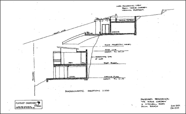
Figure 1: Concept Sketch
from Heads of Agreement
Development
Consent for Subdivision of Land
On 11 November 2004, a Development Application (N0824/04) to
subdivide the land into two allotments was lodged with Council. This
application was consistent with the signed Heads of Agreement. On 4 April 2005,
Council consented to the subdivision into two allotments subject to conditions.
The steep topography of the site and the need to maintain
the viewing platform created challenges in relation to a two-dimensional
subdivision, resulting in the creation of the two properties via stratum
subdivision. A stratum subdivision creates allotments which
are limited in height or depth, allowing properties to be effectively created
on top of each other. The subdivision created the following allotments:
· Lot 1 DP1086858, now known as 6 Mitchell Road – Containing the
existing dwelling and parking space underneath the viewing platform at the rear
of the lot.
· Lot 2 DP1086858, now known as 6A Mitchell Road – Containing
the Bible Garden and the viewing platform above the parking space on Lot 1.
A location map of
6 Mitchell Road (the subject of the Planning Proposal) and 6A Mitchell Road
(the Bible Garden) is in Figure 2. The portion of land between the two
allotments, identified in the Heads of Agreement for the garage and viewing
platform, is subdivided in
stratum, and is split between both allotments. This land is identified with the white bubble. In relation to this
part of the land, the Deposited Plan and registered easements stipulate:
· Lot 1 (6 Mitchell Road) is limited in title to a
height of 74.5 AHD.
· Lot 2 (6A Mitchell Road) is limited in title to
a depth of 74.5 AHD.
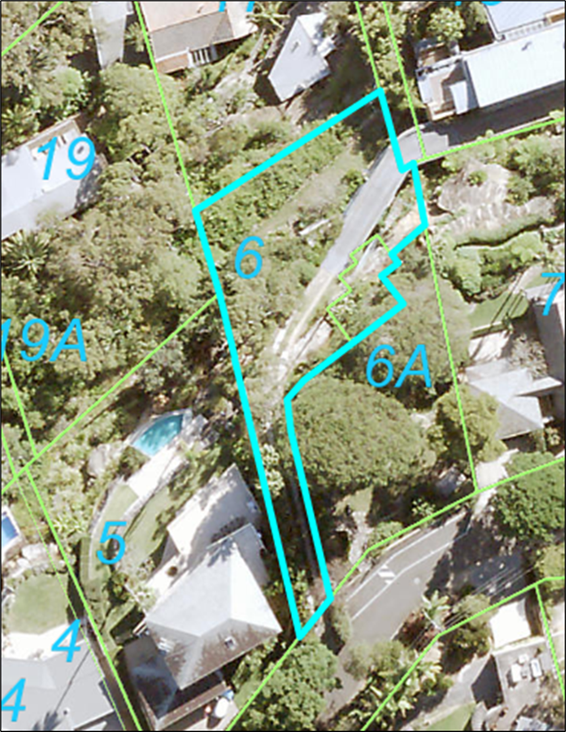

Figure 2: Location Map of 6
and 6A Mitchell Road, Palm Beach
6A Mitchell Road was transferred into
Council ownership on 7 February 2006 and classified as community land under
Council’s Land Register in accordance with the Local Government Act
1993. Although Council owns this land, it is managed by the Friends of the
Bible Garden Memorial via a Management Deed signed by Council, The Trustees of
the Bible Garden and then owner of 6 Mitchell Road on 23 March 2006.
On 18 December 2006, Council adopted the
Bible Garden - Palm Beach Plan of Management, which lists what land uses are
permissible (as exempt development or with consent) under this adopted plan. A
copy of the signed Management Deed is also appended to the adopted Plan of
Management.
Figure 3 is an excerpt from the Planning Proposal and is a
picture taken from 6A Mitchell Road (the Bible Gardens) looking north over 6
Mitchell Road. The red string (shown in the white bubble) identifies the
stratum boundary between the properties at a height of 74.5 AHD. The yellow
string represents the existing ground level (76.3 AHD) of the viewing platform
on the Bible Gardens.

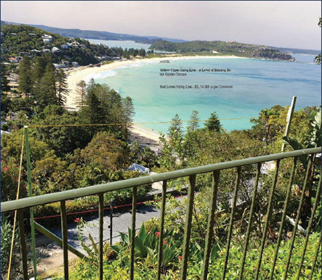
Figure 3: Extract from Planning Proposal - Site
picture with height poles
Pittwater Local
Environmental Plan 1993
On 30 March 2007, 6A Mitchell Road was
rezoned under the Pittwater Local Environmental Plan 1993, from Zone No. 2 (a)
(Residential “A”) to Zone No 6 (a) (Existing Recreation
“A”). This included the viewing platform land above 74.5 AHD.
The lower allotment containing the dwelling
house, 6 Mitchell Road, remained Zone No. 2 (a) (Residential
“A”). This includes the portion of land below 74.5 AHD.
An extract of the zoning map, obtained from
the adopted Bible Garden Plan of Management, is in Figure 4.
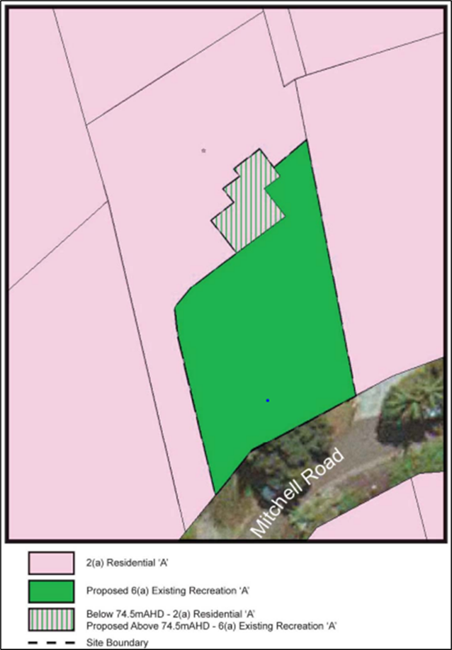
Figure 4: Zoning
under Pittwater LEP 1993
Pittwater Local
Environmental Plan 2014
On 26 June 2014, the Pittwater Local
Environmental Plan 2014 (Pittwater LEP 2014), prepared under the Standard LEP
Template, came into effect, repealing Pittwater LEP 1993.
This resulted in the properties being zoned
as follows:
· 6 Mitchell Road, Palm Beach (the subject of the Planning Proposal)
– The land was rezoned from Zone No. 2 (a) (Residential “A”)
as follows:
· majority of the site is zoned C4 Environmental Living; and
· the portion of the site directly underneath the Bible Garden’s
viewing platform (below 74.5 AHD) became zoned RE1 Public Recreation.
· 6A Mitchell Road, Palm Beach was rezoned from Zone No 6 (a)
(Existing Recreation “A”) to RE1 Public Recreation.
An extract of the Pittwater LEP 2014 zoning map is in Figure 5.
Figure 5: Zoning
Map Pittwater LEP 2014
Recent
Development Application
On 25 January 2021, Council received a
Development Application (DA2020/1596) for 6 Mitchell Road to construct a
dwelling house including a swimming pool, driveway, and garage. Components of
the dwelling house, primarily the garage and lift were proposed to be sited on
that portion of land zoned RE1 Public Recreation.
On 18 August 2021, the DA2020/1596 was
refused. The primary reason for refusal was that the residential development
proposed to be built on that portion of the site zoned RE1 Public Recreation is
prohibited under the zone.
Pre-Lodgment
Meeting
Following refusal of DA2020/1596,
pre-lodgement meetings were held between the landowner’s legal
representatives and Council on 19 August and 14 December 2021 to discuss the
RE1 zoning on the portion of the land.
Site
Description
The subject site, known as 6 Mitchell Road,
Palm Beach (Lot 1, DP 1086858), is a battle axe shaped lot located on the
northern side of Mitchell Road. Access to this property is provided via an
elevated driveway from Mitchell Road along the western (side) boundary. This
elevated driveway also provides access to 15 Florida Road, located north-east
of the subject site (see Figure 6).
Figure 6:
Locality Map
An existing dwelling is located on the
lower portion of the subject site. Pedestrian access into the dwelling from
Mitchell Road is via stairs sited beside the elevated driveway.
6 Mitchell Road is Zoned C4 Environmental
Living and RE1 Public Recreation under the Pittwater LEP 2014. The surrounding
Properties are a mix of established low density residential areas zoned C4
Environmental Living.
The Bible Garden at 6A Mitchell Road not
only abuts this land but overhangs directly above a portion of the subject site
from a depth of 74.5 AHD. 6A Mitchell Road (inclusive of the overhang) is a
locally listed heritage item. Due to the nature of the stratum subdivision, the
portion of the subject site underneath the Bible Garden overhang is also listed
as a heritage item. A picture showing the relationship between the Bible Garden
overhang and the portion of 6 Mitchell Road underneath is in Figure 7 (shown
in the white bubble).
 Figure 7: Location of Bible Garden overhang between 6 and 6A Mitchell Road
The Proposal
On 12 September 2022, Council received a
proponent-initiated Planning Proposal for 6 Mitchell Road, Palm Beach (Lot 1,
DP 1086858), submitted by Planning Hub.
The intent of the Planning Proposal is to
amend the Pittwater LEP 2014 to include an additional permitted use of a
‘dwelling house’ on the RE1 zoned portion of the site (being the
land below the Bible Garden viewing platform) to facilitate future residential
development in line with the intended use of the site as outlined in the Heads
of Agreement, signed 9 February 2004, between the Trustees of the Bible Garden
and Pittwater Council.
A provision is also proposed restricting
the building height of any future residential development on the site to 74.5
AHD, ensuring that the views of Palm Beach from the Bible Gardens are
preserved.
Assessment Of
Planning Proposal
An assessment of the Planning Proposal was
undertaken in accordance with the Department of Planning and
Environment’s Local Environmental Plan Making Guideline 2022, as follows.
Part 1- Objectives or Intended
Outcomes
The objectives and intended outcomes of the
Planning Proposal are to seek an amendment to PLEP 2014 to allow a section of
the subject site, zoned RE1 Public Recreation, to permit development for the
purposes of a dwelling house; and to seek that residential development on the
site cannot exceed a height of 74.5 AHD.
Applying the rules of the Standard LEP
Template required that land, including land beneath 74.5 AHD under the Bible
Garden overhang was zoned RE1 Public Recreation under Pittwater LEP 2014.
This change in zoning under Pittwater LEP
2014 resulted in the prohibition of a dwelling house on that portion of site
zoned RE1, contrary to the signed Heads of Agreement.
The Planning Proposal seeks to rectify this
zoning prohibition, to permit a dwelling house on a small portion of the land.
This is considered reasonable and in keeping with the signed Heads of Agreement
upon which Council received dedication of the Bible Garden land.
Imposing a building height of 74.5 AHD for
any future residential development on the subject site is also appropriate and
is consistent with the signed Heads of Agreement.
The Planning Proposal is site-specific and
can only be applied to 6 Mitchell Road, Palm Beach.
Part 2 – Explanation of
Provisions
The Planning Proposal amends the following
provisions of the Pittwater LEP 2014:
· Additional Permitted Uses Map for the subject site (Sheet APU_015)
to identify the portion of the site zoned RE1 Public Recreation for additional
permitted uses referenced in Schedule 1 of LEP.
· Schedule 1 to include a provision relating to the subject site that
would permit development for the purposes of a dwelling house. Schedule 1 is to
also detail that any future residential development on the site cannot exceed a
height of 74.5 AHD.
The amendments
support the creation of an additional permitted use for a dwelling house on
that portion of the land currently zoned RE1. This is best served by amending
the Additional Permitted Uses Map, to identify 6 Mitchell Road as referenced in
Schedule 1 of Pittwater LEP 2014.
Currently, the Height of Building Map and
Clause 4.3 Height of Buildings under Pittwater LEP 2014 applies to the land.
The proposal to require that any future residential development on the site
cannot exceed a height of 74.5 AHD by way of Schedule 1 is appropriate. This
will apply to all of 6 Mitchell Road and not just the portion of the site zoned
RE1. This restriction will apply in addition to the existing height provisions
of the Pittwater LEP 2014 which will remain unchanged.
The measurement of 74.5 AHD ensures that
any future development is below the level of the Bible Gardens and thus retains
significant and important views to the ocean, Pittwater and beyond.
Accordingly, it is proposed to amend the
Explanation of Provisions to read as follows:
a) Amend the Pittwater LEP 2014 Additional Permitted Uses Map for the
subject site 6 Mitchell Road, Palm Beach (Sheet APU_015) to identify the site
for additional permitted uses referenced in Schedule 1 of Pittwater LEP 2014.
b) Amend Schedule 1 of the Pittwater LEP 2014 to include a provision
for 6 Mitchell Road, Palm Beach:
· Permit development for the purposes of a dwelling house on that
portion of the land zoned RE1 Public Recreation.
· In addition to any other provision in this Plan, any future
residential development on 6 Mitchell Road, Palm Beach cannot exceed a height
of 74.5 AHD.
Part 3 – Justification
Strategic Merit
Section A – Need for the Planning
Proposal
Q1. Is the
Planning Proposal a result of an endorsed Local Strategic Planning Statement,
Strategic Study or report?
The Planning Proposal is not the result of
the Northern Beaches Local Strategic Planning Statement, strategic study, or
report.
The proposal is consistent with the Heads
of Agreement signed in 2004 by Pittwater Council and the then owners of the
land. It is also consistent with several objectives and priorities within the
Northern Beaches Local Strategic Planning Statement - Towards 2040 (detailed in
Q4 below).
The proposal will enable appropriate
residential development that recognises the heritage significance of the site
and surrounding area, and will not adversely impact on the ecological,
cultural, or scenic significance of the site and surrounding area.
Q2. Is
the Planning Proposal the best means of achieving the objectives or intended
outcomes, or is there a better way?
Yes, a Planning Proposal is the only way of
achieving the objectives and intended outcomes for this site that is also
consistent with the signed Heads of Agreement.
The signed Heads of Agreement included a
condition that any future residential development cannot exceed 74.5 AHD.
Allowing a ‘dwelling house’ as
an additional permitted use, on a minor portion of the site that is zoned RE1
Public Recreation will not result in any of the following:
· a practical reduction of land that is to be used for public open
space or recreational purposes;
· endangering and weaken the natural environment for recreational
purposes; and
· diminishing public use of, or access to, public open space
resources.
Section B - Relationship to Strategic
Planning Framework
Q3. Will
the Planning Proposal give effect to the objectives and actions of the
applicable regional, or district plan or strategy (including any exhibited
draft plans or strategies)?
The Planning Proposal is consistent with
both the Greater Sydney Region Plan and the North District Plan.
The Planning Proposal will also achieve the
following objectives under the Greater Sydney Region Plan:
· Objective 7: Communities are healthy, resilient and socially
connected
· Objective 13: Environmental Heritage is identified, conserved and
enhanced
· Objective 28: Scenic and cultural landscapes are protected
· Objective 31: Public Open Space is accessible, protected and
enhanced
Q4. Is
the planning proposal consistent with a council’s local Strategy or other
local strategic plans?
The Planning Proposal is consistent with
the Northern Beaches Local Strategic Planning Statement (LSPS). The additional
height restriction will ensure that views to Palm Beach from the Bible Garden
are preserved and there is minimal impact on the heritage significance of the
Bible Garden.
The Planning
Proposal is most consistent with the following priorities of the LSPS:
· Priority 6 - High quality open space for
recreation
· Priority 11 - Community facilities and services
that meet the changing community needs
· Priority 18 - Protected, conserve and celebrated
heritage.
· Priority 29 - A thriving, sustainable tourism
economy
Q5. Is
the planning proposal consistent with applicable State Environmental Planning
Policies (SEPPs)?
The Planning
Proposal is not inconsistent with the State Environmental Planning Policies
(SEPP) as listed in the Table below:
|
SEPPs (as at March 2022)
|
|
Focus Areas
|
State Environmental Planning Proposal
|
Applicable
|
Is the Planning Proposal consistent
with SEPP?
|
|
Housing
|
Housing SEPP
|
N/A
|
N/A
|
|
Transport and Infrastructure
|
Transport and Infrastructure SEPP
|
N/A
|
N/A
|
|
Primary Production
|
Primary Production SEPP
|
N/A
|
N/A
|
|
Biodiversity and Conservation
|
Biodiversity and Conservation SEPP
|
YES
|
YES
|
|
Resilience and Hazards
|
Resilience and Hazards SEPP
|
YES
|
YES
|
|
Industry and Employment
|
Industry and Employment SEPP
|
N/A
|
N/A
|
|
Resources and Energy
|
Resources and Energy SEPP
|
N/A
|
N/A
|
|
Planning Systems
|
Design Quality of Residential Apartment
Development
|
N/A
|
N/A
|
|
Precinct SEPPs
|
|
|
· Eastern Harbour City SEPP
|
N/A
|
N/A
|
|
· Western Parkland City SEPP
|
N/A
|
N/A
|
|
· Central River City SEPP
|
N/A
|
N/A
|
|
· Regional SEPP
|
N/A
|
N/A
|
|
Codes SEPP
|
N/A
|
N/A
|
|
No.65
|
Design Quality of Residential Apartment
Development
|
N/A
|
N/A
|
|
|
State Environmental Planning Policy
(Building Sustainability Index: BASIX) 2004
|
YES
|
YES
|
|
|
(State Environmental Planning Policy
(Exempt and Complying Development Codes) 2008
|
YES
|
YES
|
Q6. Is the Planning Proposal
Consistent with Applicable Ministerial Directions (Section 9.1 Directions)?
Apart from the Ministerial Direction 1.4
Site Specific Provisions, the Planning Proposal is consistent with the
applicable Local Ministerial Directions. Direction 1.4 Site Specific
Provisions, reads as follows:
(1) A planning proposal that will amend
another environmental planning instrument in order to allow particular
development to be carried out must either:
(a) allow that land use to be carried out in the
zone the land is situated on, or
(b) rezone the site to an existing zone already
in the environmental planning instrument that allows that land use without
imposing any development standards or requirements in addition to those already
contained in that zone, or
(c) allow that land use on the relevant land
without imposing any development standards or requirements in addition to those
already contained in the principal environmental planning instrument being amended.
A planning proposal may be inconsistent
with the terms of this direction only if the relevant planning authority can
satisfy the Planning Secretary (or an officer of the Department nominated by
the Secretary) that the provisions of the planning proposal that are
inconsistent are of minor significance.
The Planning Proposal seeks to allow an
additional permitted use of ‘dwelling house’ on that part of the
land zoned RE1 Public Recreation and add an additional height restriction to
the land.
The proposed amendments are consistent with
the Heads of Agreement and the inconsistency with Direction 1.4 Site Specific
Provisions is of minor significance and limited to this property.
Site-Specific Merit
Section C- Environmental, Social and
Economic Impact
Q7. Is
there any likelihood that critical habitat or threatened species, populations
or ecological communities, or their habitats, will be adversely affected as a
result of the proposal?
6 Mitchell Road Palm Beach is identified on
the Pittwater LEP 2014 Biodiversity Map - Sheet BIO_015, and as a result calls
up Clause 7.6 Biodiversity under the LEP.
A Flora and Fauna Assessment by EcoLogical
Australia (May 2022) and an Arborist Report by Arbosaw (June 2022) accompanied
the Planning Proposal application.
The Flora and Fauna Assessment undertook a
threatened species ‘test of significance’ assessment incorporating
the following:
· On ground surveys on 18 August and 3 September 2019, and 14 May
2022.
· Bionet searches for flora, fauna and endangered populations to
identify if there were previous records of threatened species occurring within
the local area using a 10km radius around the site.
· A review of the Planning Proposal and the proposed development it
seeks to enable was evaluated for potential environmental impacts.
No threatened
plant or animal species were found on and within immediate vicinity of this
property.
Council’s Senior Environment Officer
- Biodiversity advised as follows:
The Biodiversity Planning team do not
raise any other issues or concerns in relation to the current Planning
Proposal.
I note the updated Flora & Fauna
Assessment which has assessed the biodiversity values of the portion of the
site zoned RE1 Public Recreation, and generally agree with the report findings,
namely that a significant impact to the environment is unlikely and the NSW
biodiversity Offset Scheme is not triggered. A range of suitable management and
mitigation measures are also detailed within the Report that could be applied
to any future development of the site.
The Planning Proposed is not likely to
adversely impact on critical habitat, threatened species, populations, or
ecological communities.
The Arborist Report concluded that the
Planning Proposal is suitable from a tree impact perspective provided the
recommendations are implemented during the approval of any future Development
Application.
Q8. Are
there any other likely environmental effects as a result of the planning
proposal and how are they proposed to be managed?
Geotechnical
The subject site is identified as being a
Geotechnical Hazard H1 on the Geotechnical Hazard Map. A Geotechnical
Report prepared by Davies Geotechnical Consulting Engineers (July 2022)
accompanied the Planning Proposal application.
This report concludes that the geotechnical
conditions of the site will not affect consideration of the Planning Proposal.
Heritage
A Heritage report by Weir Phillips (21 July
2022) accompanied the Planning Proposal application. The report concluded that
the proposed additional permitted use within the small portion of land zoned
RE1-Public Recreation will have no impact on the significance of the adjoining
heritage item (Bible Garden) for the following reasons:
· The proposed additional permitted use is in character with the original
concept scheme envisaged when the site was subdivided and sold as part of the
Heads of Agreement between Pittwater Council and the Trustees of the Bible
Garden.
· The steep topography of the northern portion of the subject site is
unusable by patrons of the Bible Garden. An additional permitted use in this
portion of the site allows for a construction of a dwelling with a flat top
structure (potential garage).
· Additional permitted use within the RE1 zoning will not result in a
built form that when viewed from the most significant points at Mitchell Road
and from within the Bible Gardens the dwelling will be concealed by the
existing topography. There will be no visual impact from this perspective.
· The character of the Bible Garden, as a site enjoyed for quiet
contemplation and appreciation of the magnificent outlook towards Palm Beach
will be unaffected by the proposed additional permitted use within the RE1
zoning.
· The proposed additional permitted use within the RE1 zoning is
unlikely to reduce the user’s ability to interpret the cultural landscape
of the Bible Garden within its context.
· From Palm Beach and surrounds, a new dwelling built as a result of
the additional permitted use in RE1 would be visible as one of a number of
residential developments within the escarpment behind Palm Beach as a result of
the proposed additional permitted use. Any new dwelling constructed would be
visible in the landscape from these viewpoints but will have a lessened visual
impact due to the scale and constrained nature of the site in comparison to
other nearby residential developments. The visual impact from this perspective
is considered to be minor.
· No other heritage items in the vicinity will be affected by future
built form constructed as part of the planning proposal owing to the separation
of these items from the subject site.
Council’s
Heritage Officer concurs with the report’s conclusions and supports the
Planning Proposal from a heritage perspective as it will:
· Enable a dwelling to be constructed as envisaged by the Heads of
Agreement between Council and the Bible Garden Trust; and
· Not impact upon the heritage significance of The Bible Garden; and
· Not impact upon important significant views from the garden out to
Pittwater, Palm Beach and beyond.
View Loss
The proposal provided a detailed account of
a study conducted in consultation with the Committee of the Friends of the Palm
Beach Bible Garden. Height poles were installed to determine the potential
impact of any future development on the RE1 zoned land. The study concluded
that no portion of future residential development on this land will impede on
existing views from the Bible Garden based on topography of the site and the
existing covenants over the land.
The Planning Proposal seeks to add a height
restriction for any future residential development on 6 Mitchell Road. This is
in addition to the existing height provisions in the Pittwater LEP 2014 and
will ensure that views from the Bible Garden are preserved and consistent with
the signed Heads of Agreement.
Q9. Has
the Planning Proposal adequately addressed any social and economic effects?
The Planning Proposal will facilitate
residential development on the whole of 6 Mitchell Road, consistent with the
signed Heads of Agreement.
The proposal will not result in additional
dwellings being permitted on the land. It will facilitate a dwelling house, and
development ancillary to a dwelling (e.g., a garage), to be permissible on that
part of the land zoned RE1.
Limiting the height of future residential
development on the land ensures no obstruction of views from the Bible Garden.
This allows the land to be used and enjoyed by the owners and the community.
Section D - State and Commonwealth
Interests
Q10. Is there
adequate public infrastructure for the Planning Proposal?
6 Mitchell Road is an existing serviced
property within an established neighborhood. The Planning Proposal will not
result in additional dwellings being permitted on the land and will not require
additional public infrastructure.
Q11.
What are the views of state and Commonwealth public authorities consulted in
accordance with Gateway determination?
If the Planning Proposal progresses and
receives a Gateway Determination, the following public authorities will be consulted:
· Sydney Water
· Ausgrid, and
· NSW Office of Environment and Heritage.
CONSULTATION
The Planning Proposal submitted by the proponent was
initially placed on non-statutory public exhibition for 14 days, from 28
September to 13 October 2022, in accordance with the Northern Beaches Community
Participation Plan. Following a request from a submitter, the public exhibition
period was extended to 21 October 2022. The public exhibition comprised:
· Notification letters to adjoining landowners and occupiers
· Email to community members who had registered their interest in the
project
· An updated Council ‘Your Say’ page with relevant
information; and
· Inclusion in Council’s Community News email.
Six (6) submissions were received.
The issues raised in submissions included:
· Request for the garage to be lowered
· Vegetation that will feature on garage roof should be at maximum
development height
· New structure will obscure view
· Unlawful public exhibition and Planning Proposal
· The proposed amendments are unclear
· Extension of public exhibition
· Planning Proposal is unlawful.
Issues relating to landscaping and
the potential design of the garage are not relevant to the Planning Proposal
and will be considered in any future Development Application. The Planning
Proposal has been lawfully prepared and considered in accordance with all
statutory requirements.
A summary of the submissions and responses to the issues
raised is in Attachment 3. These issues do not warrant the rejection of the
Planning Proposal.
Local Planning
Panel
On 14 December 2022, an assessment of the
Planning Proposal was presented to the Northern Beaches Local Planning Panel.
The proceedings in Brief from the meeting included the following comments:
At the public
meeting Counsel for an objector submitted that: (a) there were two planning
proposals before the Panel, one by The Planning Hub on behalf of the applicant
and the other by Council as set out in Attachment 2 to the Council assessment
report; (b) that the former was beyond power under the Environmental Planning
and Assessment Act 1979 but that the latter was within power and the Panel
could advise in respect of the latter; (c) that the Panel should reject the
former and advise Council only in respect to the latter. The Panel considers
that there is only one planning proposal before it, namely the Council’s
planning proposal set out in Attachment 2 to the Council assessment report. The
Panel will advise Council only in respect of that planning proposal.
Subsequently, the Planning Panel
recommended:
That the Northern Beaches Local Planning Panel recommends
that Council support the planning proposal set out in Attachment 2 to the
Council assessment report to permit a dwelling house limited to a building
height of RL 74.5 AHD as an additional permitted use on 6 Mitchell Road Palm
Beach, for the reasons presented in the assessment report, subject to the
following:
The Panel suggests that the additional clauses in
Schedule 1 of the Pittwater Local Environment Plan should read to the following
effect:
Use of certain land at 6
Mitchell Road, Palm Beach
(1) This
clause applies to land at 6 Mitchell Road, Palm Beach, being Lot 1. DP1086858
and identified as on the Additional Permitted Uses Map.
(2) Development
on the part of 6 Mitchell Road, Palm Beach zoned RE1 for the purposes of a
dwelling house, not exceeding RL 74.5AHD in height, is permitted with
development consent.
(3) The
height limit restriction of RL 74.5AHD also applies to the remainder of 6
Mitchell Road, Palm Beach, currently zoned C4.
(4) Subject
to the restriction imposed by clause 3, the remainder of 6 Mitchell Road, Palm
Beach continues to be subject to the development height controls in clause 4.3
of the Pittwater Local Environmental Plan.
Vote: 4/0
The Planning Proposal has been amended in line with the
suggestion provided by the Local Planning Panel.
The minutes of the Local Planning Panel meeting are in
Attachment 4.
External
Probity Adviser
On 24 October 2022, Council engaged the services of external
probity adviser Charles Kendall Australia to oversee Council’s assessment
of the Planning Proposal. Probity advice was sought to manage any potential or
perceived conflict of interest arising from the assessment of a Planning
Proposal on land adjacent to the Council-owned Bible Gardens.
Charles Kendall Australia has undertaken an audit of the
assessment process. The audit report is provided in Attachment 5. The audit
report concluded that the were no probity concerns with the assessment of the
Planning Proposal.
TIMING
It is anticipated that the timeframe for completion of the
Planning Proposal is approximately 12-18 months from the date of
Council’s approval.
Following the issue of a Gateway Determination, Council will
be required to formally exhibit the Planning Proposal for 28 days. The outcomes
of this exhibition will be reported back to Council for consideration.
LINK TO STRATEGY
The Planning Proposal relates to the
following goals of the Northern Beaches Community Strategic Plan 2040 outcome
of:
· Community and belonging - Goal 7 Our diverse community is supported
to participate in their chosen cultural life
· Community and belonging - Goal 8 Our community feels safe and
supported
· Community and belonging - Goal 9 Our community is inclusive and
connected
· Housing, places and spaces - Goal 11 Our local centres are vibrant
and healthy, catering for diverse economic and social needs
· Partnership and participation - Goal 22 Our Council builds and
maintains strong partnerships and advocates effectively on behalf of the
community
financial considerations
The Planning Proposal is a proponent-initiated application.
The proponent has paid the assessment fees stipulated in Council’s Fees
and Charges 2022/23.
The recommendations of this report pose no financial impact
on Council.
social considerations
The proposal seeks to rectify an anomaly unique to this site
and is consistent with the signed Heads of Agreement.
The Planning Proposal will maintain the existing views from
the Bible Garden and is not anticipated to have any adverse social impacts.
environmental considerations
An assessment of the Planning Proposal has determined that
it is unlikely to have any adverse environmental impacts on the subject site or
surrounding land.
governance and risk
considerations
The Planning Proposal has been assessed is accordance with
all statutory requirements.
Independent probity advice was sought to manage any
potential or perceived conflict of interest arising from the assessment of the
Planning Proposal. The audit report concluded that the were no probity concerns
with the assessment of the Planning Proposal.
|
|
Report To Ordinary Council MEETING
|
|
ITEM NO. 13.1 - 28 February 2023
|
13.0 Transport and Assets Division
Reports
|
ITEM 13.1
|
Response
to Notice of Motion No 36/2022 - Potholes on Local Roads
|
|
REPORTING
MANAGER
|
Executive
Manager Transport & Civil Infrastructure
|
|
TRIM
file REF
|
2023/045030
|
|
ATTACHMENTS
|
NIL
|
purpose
To provide a response to Council’s
Notice of Motion No 36/2022 - Potholes on Local Roads adopted at its ordinary
Council meeting on 22 November 2022.
REPORT
At its ordinary meeting on 22 November 2022
Council resolved (377/22):
That:
1. The Chief
Executive Officer report back to Council’s February 2023 meeting on the
current number of potholes on local roads and number of local roads whose
overall surfaces have been badly damaged by rain this year, with an estimate of
how much it would cost to repair current individual potholes, and to resurface
roads whose overall surfaces have deteriorated due to rain.
2. The Chief
Executive Officer report on how much funding has been spent on (a) fixing
potholes and (b) resurfacing roads this financial year and how much remains in
the budget to fix current and future potholes and road surfaces.
3. Staff
identify and report back to Council’s February 2023 meeting on funding
included in this year’s budget from current capital works projects that
have failed to find suitable tenders that could be used to fix potholes and
resurfacing roads badly damaged by this year’s rain.
4. If no such
funding is available, identify money from other projects not impacted by this
year’s weather that could be spent on road repairs and resurfacing.
5. Council
lobby the NSW government to provide more funding for fixing potholes on local
roads and resurfacing local roads badly damaged by this year’s
rain.
6. Council
calls on the NSW Government to promptly repair state roads in the Northern
Beaches Local Government Area.
In response to Item 1:
Between July 2022 and January 2023:
· Council has repaired 3,346 potholes in the above period
· 1,114 individual local roads have been identified where pavements
have been damaged as a result of the recent periods of wet weather
· $1.9 million has been spent on pothole repairs and road patching,
with some $3 million additional heavy patching programmed for the remainder of
this year and around $7 million proposed for next financial year (some from
normal allocations and around $6 million from the recent State Government Grant
for Local and Regional Road repairs)
· $25-30 million is the estimated cost to fully resurface roads whose surfaces have deteriorated due to rain.
In response to Item 2:
Council has spent the following amounts this
financial year
(a)
As noted above $1.9 million on fixing potholes and on heavy patches so far this year with around
$3 million currently in hand and being scoped as a result of State Government
grant
(b)
$5.5 million completed or currently in progress on resurfacing roads this
financial year (to January 2023).
There remains approximately $2.6 million from the $8.1 million Road Re-sheeting
Capital Works budget to complete the current program of works. These works have
been scoped and are in the process of having contractors engaged to deliver the
works program.
In response to Item 3 and 4:
Council is committed to the delivery of the
current adopted capital works program. Should our procurement processes fail to
find suitable tenders on the first occasion, the procurement strategy is
reviewed and addressed depending on the individual situation. It is considered
that there are no capital works projects in the current program, where funding
should be diverted to repairing potholes and resurfacing roads at this
time. It is noted that much of our capital works program funding is
either tied to grant funding, restricted funds (e.g., s7.11 & s7.12 funds),
or required to meet other asset renewal ratios.
The recent State Government announcement of
$500 million for Council’s to repair Regional and Local Roads would be
best suited funding the road pavement repairs. Council has been advised that
the allocation to Northern Beaches Council is $9.1 million and will need to be
completed by February 2024. Actions have already commenced to undertake these
works.
In response to Item 5 & 6:
Council has
written to the Hon. Natalie Ward, MLC, Minister for Metropolitan Roads and Minister
for Women’s Safety and the Prevention of Domestic and Sexual Violence
welcoming funding of the $500 million Regional and Local Roads Repair Program
and requesting further action on the State Road network in the Northern Beaches
Local Government area.
The funding boost to
improve our Local and Regional Road network is welcomed and Council has
requested consideration be given to a general increase in road funding to keep
our road network safe, efficient, and reliable now and into the future.
LINK TO COUNCIL STRATEGY
This report relates to the Community
Strategic Plan Outcome of:
Transport, technology and connectivity -
Goal 17 Our community can safely and efficiently travel within and beyond the
Northern Beaches
FINANCIAL CONSIDERATIONS
The recommendations of this report pose no
financial impact on Council.
ENVIRONMENTAL CONSIDERATIONS
There are no environmental impacts
associated with the recommendations of this report.
Social considerations
There are no social considerations
associated with the recommendations of this report.
governance and risk
considerations
There are no risk or governance issues
associated with the recommendation of this report.
RECOMMENDATION OF Director Transport and Assets
That Council note the information provided in this report.
|

|
Report To Ordinary Council MEETING
|
|
ITEM NO. 15.1 - 28 February 2023
|
15.0 Notices of Motion
|
ITEM 15.1
|
Notice
of Motion No 1/2023 - Parking Restrictions Request, Pittwater Road, Collaroy
|
|
TRIM
file REF
|
2023/082444
|
|
ATTACHMENTS
|
NIL
|
Submitted by:
Councillor Vincent De Luca OAM
That Council formally write to the NSW
Minister for Roads and the Shadow Minister for Roads requesting the
implementation of hourly parking restrictions on Pittwater Road from the
intersection of Anzac Parade and Pittwater Road to Hadleigh Avenue, Collaroy to
prevent cars for sale taking up much needed residents’ and beach user
parking and posing safety risks with potential purchasers walking on Pittwater
Road to inspect vehicles.
|
|
Report To Ordinary Council MEETING
|
|
ITEM NO. 15.2 - 28 February 2023
|
|
ITEM 15.2
|
Notice
of Motion No 2/2023 - Beach Safety Signs
|
|
TRIM
file REF
|
2023/090901
|
|
ATTACHMENTS
|
NIL
|
Submitted by:
Councillor Michael Gencher, Councillor Rory Amon
That:
1. In
an ongoing effort to reduce the drowning toll, Council work with local Surf
Life Saving Clubs, Surf Life Saving Northern Beaches, and Surf Life Saving
(SLS) NSW to identify and investigate and participate in available innovative
projects and programs that specifically target high risk locations/user groups
and to further improve public awareness.
2. Council
consider the installation of improved, prominent beach safety signs as
permanent installations at beach entrances, and the general proximity of coastal
areas – to complement the temporary warning signage, services and
information currently provided by local Surf Life Saving Clubs and coastal
Lifeguard services.
3. Council
consider the installation of improved permanent and prominent beach safety
signage at identified blackspot locations throughout the Northern Beaches. A
blackspot location is one that, historically, has had a high number of coastal
safety related incidents including preventions, rescues, emergency call outs
and drownings – or being an unpatrolled beach – or area of beach.
4. Council
consider the production and installation of permanent and prominent beach
safety signage and translations of key beach safety messages in multiple
languages - as is currently standard practice for several Councils.
5. An
agreed action plan be prepared, and Council briefed by July 2023 – with
the above actions to be funded from relevant operational budgets (if adopted),
and if adopted, to be ready for implementation by September 2023 – to
coincide with the start of summer and the SLSA Patrol Season.
______________________________________________________________________________
BACKGROUND FROM
COUNCILLOR Michael
Gencher AND COUNCILLOR RORY AMON
As at the writing of this background – Thursday, 9
February 2023, there have been fifty-six drowning deaths in Coastal and Inland
Waterways in NSW this summer. Beach safety signs are designed to send clear
messages and warnings.
Surf Life Saving (SLS) NSW has indicated that coastal
drownings are up 30 per cent on the 10-year average – with a 13 per cent
increase on last year.
This summer the drowning toll is the highest on record –
including several tragic drownings on our Northern Beaches.
According to the National Coastal Safety Report 2022, 939
coastal drowning fatalities were recorded from 2012-2022, almost half of which
were overseas-born beachgoers. However, the 939 fatalities were only of people
whose birth continent was known, so the total number of drownings is higher.
Current research indicates that 50 per cent of beach goers
born overseas and approximately 40 per cent of locals rarely see, or never read
beach safety signage at beaches they are not familiar with.
Approximately half of the overseas-born beachgoers had no
understanding of some beach safety terms such as, rip, bank, high surf, shore
dump, or bluebottles.
Not seeing, not reading, and not understanding the signs,
could, and does have deadly consequences.
Research indicates that many people are also unsure about what
the Australian beach flags mean - while they represent ‘always swim
between the flags’, more than 30 per cent of the overseas visitors and
residents believe that beach flags mean that only people ‘perceived to be
good swimmers’ were allowed to be between the flags.
Another common flag instruction – ‘No flags = no
swim’ – is also confusing, with research showing that this
instruction is perceived as – ‘they may not swim, but they may
play, walk, and stand/wade in the water’.
Currently, local Surf Life Saving Clubs are having to deal
with an overwhelming number of preventions and rescues, due to the lack of
signage and information. The local surf clubs are having to hire (at their own
expense) variable message sign (VMS) boards with safety and information
messaging to protect beachgoers.
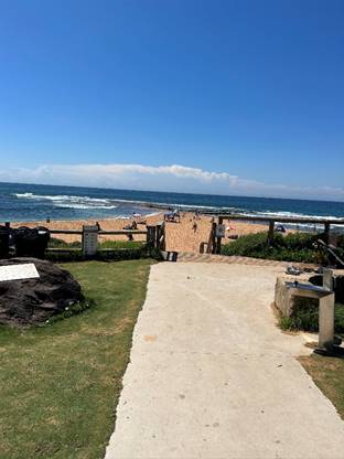
|
|
Report To Ordinary Council MEETING
|
|
ITEM NO. 15.3 - 28 February 2023
|
|
ITEM 15.3
|
Notice
of Motion No 3/2023 - Cashless Gaming Card Reform
|
|
TRIM
file REF
|
2023/101013
|
|
ATTACHMENTS
|
NIL
|
Submitted by:
Councillor Rory Amon
That Council:
1. Supports, in principle, the NSW Government-announced cashless gaming
card policy.
2. Write to the NSW Premier and the Leader of the Opposition informing
each of Council’s position.
BACKGROUND FROM
COUNCILLOR Rory
Amon
Problem gambling is a scourge on society.
Council can play a role in advocating for reform in this space. In 2017, this
council resolved in favour of calling on the NSW Government to put an immediate
cap on poker machine licences in the Northern Beaches LGA.
The NSW Government has announced a policy
to make every poker machine cashless by 31 December 2028. This will help combat
and reduce problem gambling and money laundering. Full details of the policy
can be read on here (https://www.nsw.gov.au/media-releases/pokies-to-be-cashless-2028-under-historic-changes#:~:text=The%20NSW%20Liberal%20and%20Nationals,laundering%20in%20electronic%20gaming%20machines) .
The policy announcement has been widely
supported, including by the Alliance
for Gambling Reform and Independent MPs, Alex Greenwich and Greg Piper (see here -
https://www.smh.com.au/national/nsw/perrottet-on-a-winner-as-advocates-and-mps-praise-pokies-reform-20230206-p5cicb.html).
|
|
Report To Ordinary Council MEETING
|
|
ITEM NO. 15.4 - 28 February 2023
|
|
ITEM 15.4
|
Notice
of Motion No 6/2023 - Brewarrina Sister City Youth Program
|
|
TRIM
file REF
|
2023/101638
|
|
ATTACHMENTS
|
NIL
|
Submitted by:
Councillor Sue Heins and Councillor Ruth Robins
That Council:
1. Investigate
future options of supporting our Sister City relationship with Brewarrina in
supporting youth from both Brewarrina and the Northern Beaches LGA.
2. Staff
prepare a report to come back within 3 months outlining future possible options
to continue this support, including the financial cost for consideration in the
2023/24 Budget.
BACKGROUND FROM
COUNCILLOR Sue
Heins AND COUNCILLOR RUTH ROBINS
Since COVID-19 our relationship with
assisting the youth of our sister city, Brewarrina and sending our youth to
Brewarrina appears to have halted.
Historically the Bush to Beach program
supported primary aged children and Brewarrina Council had a system that
brought high school achievers to the Northern Beaches and Northern Beaches
Council sent local high school achievers to Brewarrina and surrounds.
Bush to Beach has a vision to connect outback
regional areas in need with local surf lifesaving clubs as is the relationship
with South Narrabeen SLSC and Brewarrina.
There appears to be an opportunity to
reengage and for Councillors to assess which way forward in assisting to
reengage for the benefit of our youth and assist their development.
|
|
Report To Ordinary Council MEETING
|
|
ITEM NO. 15.5 - 28 February 2023
|
|
ITEM 15.5
|
Notice
of Motion No 7/2023 - Urgent Request for a Safety Audit of Electric Bike,
Electric Scooter and Other Bike Usage on Northern Beaches Shared Paths, Bike
Paths and Footpaths
|
|
TRIM
file REF
|
2023/113922
|
|
ATTACHMENTS
|
NIL
|
Submitted by:
Councillor David Walton and Councillor Sprott
That:
1. The
Northern Beaches Council Local Traffic Committee, in partnership with the
Northern Beaches Police Area Command, conduct an urgent safety audit of
electric bike, electric scooter and other bike usage, on Northern Beaches
shared paths, bike paths, and footpaths. That the safety audit include
consideration of, but not limited to:
A. Speeding;
B. Shared
path design models and factors;
C. Path
separation versus segregation;
D. Advisory
speed signage;
E. Education
and communication campaign on electric bike, scooter and other bike legislative
responsibilities; and
F. Regulatory
factors, including Council Rangers and Police operations to target
non-compliance of road rules applicable to electric bikes, scooters and other
bikes.
2. The
outcomes of the safety audit be reported back to Council as a matter of
urgency, with recommendations to mitigate the increasing risks associated with
these safety issues.
BACKGROUND FROM
COUNCILLOR David
Walton AND COUNCILLOR SPROTT
The Northern
Beaches shared paths are an area open to the public that is designated for the
use of both bicycle riders and pedestrians. The Northern Beaches is
seeing a significant increase in the use of electric bikes, scooters and other
bikes on shared bike paths with increased speeds, that a reasonable person
would consider an increasing risk to pedestrian safety.
An increasing
number of residents are contacting their elected representatives to address
this increasing safety concern.
When riding on
a shared path, the road rules require electric bicycle riders and other bike
and scooter riders to:
· Keep to the left (unless it is impractical to do so)
· Give way to pedestrians including wheeled recreational devices/toys.
You should always slow down, stopping if necessary to avoid a collision
· Keep to the left of any oncoming bicycle rider.
In line with
the Centre for Road Safety guidance, to make paths safer for everyone it is
recommended that bike riders:
· Provide pedestrians with a metre of space when passing
· Use their bell to warn others when you are approaching
· If there is room, moving off the path to the left if you wish to
stop riding
· Be careful around young children and dogs, as they are often
unpredictable in their movements, and older pedestrians who may be more vulnerable
· Travel at a safe speed so you can stop within a safe distance of
pedestrians on the path.
|
|
Report To Ordinary Council MEETING
|
|
ITEM NO. 15.6 - 28 February 2023
|
|
ITEM 15.6
|
Notice
of Motion No 8/2023 - Conservation Zones
|
|
TRIM
file REF
|
2023/119554
|
|
ATTACHMENTS
|
NIL
|
Submitted by:
Councillor Miranda Korzy
That Northern Beaches Council adopt the following principles with
regard to reviewing the Local Environment Plans of Pittwater, Warringah and
Manly:
1. Acknowledge
the overall purpose of the LEP revision must be to recognise the role of
Northern Beaches Council in protecting the unique environment of Sydney’s
northern beaches and to adopt the highest standards of environmental protection
in the existing LEPs and not to adopt a lowest common denominator approach to
environmental protection.
2. Acknowledge
that if adopting a single LEP results in reduced environmental protections then
it would be better to retain the existing LEPs, apart from the Warringah
deferred lands LEP, as current and valid legal instruments.
3. Retain
all Conservation Zones from the Pittwater Local Environment Plan 2014 (LEP) in
the Northern Beaches Council’s single Local Environment Plan, now under
development.
4. Include
any properties in areas with recognised biodiversity, tree canopy, biodiversity
corridors, as well as hazards including bushfire, flood, coastal erosion, and
landslip in Conservation Zones.
5. Retain
all controls on those Conservation Zones as provided in the Pittwater
Development Control Plan in the new DCP, moving those that are resulting in
development outside the clear intent of the Pittwater DCP into the new LEP.
6. Include
new controls in the LEP outlining Foreshore Scenic Protection areas and
limiting excavations, removal or destruction of significant rocks and cliffs,
as well as removal of building spoil from developments in Conservation Zones.
7. Report
back to council on heritage items proposed for the new LEP, ensuring all that
exist in the current Pittwater LEP are included, and that those nominated at
the time of council amalgamations in 2016 are considered.
8. If
these actions cannot be achieved under a single, harmonised Northern Beaches LEP,
exclude the former Pittwater Council area from that LEP and update the current
Pittwater LEP, as outlined in Points 4, 5, 6 and 7.
9. Table
a report to council on the Outcome of the Public Exhibition of the Draft
Conservation Zones Review, including all submissions received with redactions
as appropriate, before finalising and exhibiting the single Draft Northern
Beaches Council Local Environment Plan.
BACKGROUND FROM
COUNCILLOR Miranda
Korzy
The Northern
Beaches community and councillors were assured by council staff that no
environmental values would be sacrificed from any former council areas in the
harmonisation of the Pittwater, Warringah and Manly Local Environment Plans
(LEPs) and Development Control Plans (DCPs).
However, the Draft
Conservation Zones Review proposes removing 3,613 properties from the former
Pittwater Local Government Area’s Conservation Zones and making them
Residential Zones, with their controls undefined. This contrasts with the loss
of only one property with a Conservation Zoning from the former Warringah Local
Government Area (LGA). This scenario is in fact not harmonising zones across
the new council area but aligning them with the former Warringah
zonings.
Rob Stokes had
also tried to reassure Pittwater residents about protection of its environment
after the NSW government passed the Environmental Assessment and Planning Bill,
in December 2017. In a letter to the Avalon Preservation Association of
December 5, 2017, Mr. Stokes discussed the introduction of Local Strategic
Planning Statements. In it he said:
“The
development of these statements will see councils and communities formulate the
forward vision for land use in the local area - capturing and respecting the
local characteristics that need to be preserved and articulating what local
residents want in the future. This will include where and how any changes
should occur.
These statements
will be formally recognised in legislation and reflected in Councils’
Local Environment Plans and development controls. Councils will be able to
tailor the statements to specify land use priorities on a ward by ward
basis.”
However, the
previous council chose not to utilise this process, opting instead for an
LGA-wide LSPS. A ward based LSPS would have revealed the special characteristics
of Pittwater, and all other wards and the differences between them. We can see
the result of this in the Draft Conservation Zones Review, in which consultants
have failed to recognise the importance of, for example, wildlife corridors and
tree canopy. This has a major Impact in Pittwater - but also across the entire
LGA.
Further, the
previous council made the decision to adopt one LEP across the LGA without any
explicit discussion about the reasons for this or necessity to do so. At the
November 27, 2018 meeting, councillors voted to accept to accept the Local
Environment Plan Review and one LSPS.
However, the
report from staff did not mention the fact that there is no legislation that
requires one LEP or any ministerial directive to that effect either. This issue
was never placed before councillors or the community, and we were told that the
state government required us to introduce one LEP.
If we are to have
one LEP, it should aim for the highest standards of environmental protection
possible, as was reflected in the former Pittwater LEP and DCP. Northern
Beaches Council has a special responsibility now as the custodian of
Pittwater's precious bushland, beaches and villages, and the community expects
this to be demonstrated in the way planning for Pittwater is carried out. The
enormous response to the Draft Conservation Zones Review from concerned
Pittwater residents, who provided 60 per cent of the 935 submissions, bears
this out.
This motion aims
to do everything possible to retain and enhance the environment of the former
PIttwater LGA.
CHIEF EXECUTIVE
OFFICER REPORT
In accordance with clause 4.14 of
Council’s Code of Meeting Practice I offer the following report on this
matter to assist Council in the deliberation of this motion:
I cannot recommend this motion. It is
premature for the following reasons:
Since early 2019 Council has been
collaborating with our community to bring together our current local planning
controls to create one new planning framework that will guide and manage future
development in the Northern Beaches. We started this process with the release
in 2019 of the Local Strategic Planning Statement - Towards 2040 outlining the
future visons for the Northern Beaches and our commitment to a sustainable
future. The preparation of the Local Housing Strategy and the release of the
LEP/DCP Discussion Paper followed in 2020 and 2021.
In addition to these strategic policy
documents, Council has prepared a range of technical studies to inform the
preparation of the new LEP and DCP, including the Conservation Zones Review.
The Conservation Zones Review was exhibited
for 3 months from 2 September 2022 to 2 December 2022 following the unanimous
decision of Council to endorse the Conservation Zones Review for public
exhibition. The main aim of the public exhibition was to seek feedback from the
community on a draft methodology for the use of Conservation Zones across the
Northern Beaches LGA before Council endorses a final methodology for the
application of Conservation Zones in the draft LEP, anticipated in mid 2023.
It is on the public record (Item 12.1-
Council meeting 23 August 2022) that the Conservation Zone review was prepared
for the following reasons:
· To align with the vision of the Northern Beaches community who place
a high value on important environmental matters.
· To provide strategic and statutory protection to lands with important
environment and hazard characteristics, rather than relying on individual
assessment of development applications.
· To meet commitments made in Towards 2040, which include principles
to:
- Avoid intensification of development, inappropriate
development and incompatible land uses in areas exposed to natural hazards.
- Ensure development is avoided in high-risk areas that are
difficult to evacuate or would be occupied by at risk members of the community
(including schools, hospitals, and nursing homes).
· To provide a consistent and fair approach to the application of
conservation zones which currently permit markedly different land uses across
the four LEPs and were created using different environmental criteria.
· To identify and implement best practice planning controls based on
research and a strong evidence base, including several technical studies which
identify areas with high conservation values more accurately and consistently
across the LGA.
· To meet commitments to consult with residents in the “deferred
lands” under Warringah LEP 2000 – Oxford Falls Valley and Belrose
North – because of the non-standard nature of that LEP and given concerns
about previous Planning Proposals or the area.
935 submissions were received in response
to the public exhibition of the Conservation Zones Review and the Technical
Studies, and all submissions have been reviewed. A copy of the submissions will
be available on Council’s website by the end of February 2023, along with
a Consultation Report which summarises key issues raised in submissions and
Council’s response.
Following the review of submissions by
Council and its consultants, changes to the methodology will be made to address
community concerns. In the urban areas, one possible change being considered is
the inclusion of foreshore scenic protection areas as a criterion with medium
environmental value. This change alone will see 15,313 properties across the
Northern Beaches proposed to be zoned C3 and C4, which is 5,003 more than
currently exists under the 4 existing LEPS, and an increase in 827properties
within the Pittwater LEP area. Significantly more than the exhibited version of
the Conservation Zones Review.
It is also on the public record, that the
application of conservation zones is not the only means by which we will
protect the environment. Council’s LEP/DCP Discussion Paper and report to
Council on the Conservation Zones Review outlined several measures Council is
proposing in the new LEP and DCP in addition to land use zoning, that will
protect the environment and strengthen the current controls in the 4 existing
LEPs and DCPs.
These include: Improved and updated
provisions for biodiversity, geotechnical requirements, coastal and estuarine
hazards, heritage conservation areas, stormwater management, waterways,
wetlands, and riparian lands, environmentally sensitive areas, and foreshore
scenic protection. Other measures (not currently included in any of our
Standard Instrument LEPs) but which we are investigating for inclusion are
matters such as: Tree Canopy, including deep soil requirements and tree
replenishment rates; Landscape Controls, Floor Space Ratios Controls which will
aim to reduce building bulk (currently only applies to Manly LEP); and
excavation controls.
|
|
Report To Ordinary Council MEETING
|
|
ITEM NO. 15.7 - 28 February 2023
|
|
ITEM 15.7
|
Notice
of Motion No 4/2023 - Duffys Forest Community Bridle Trail
|
|
TRIM
file REF
|
2023/101041
|
|
ATTACHMENTS
|
1 ⇩Stokes
- Brownlee - OBO Duffys Forest Residents Association
2 ⇩NBCS
Letter of Support to Council - Duffys Forest and Terrey Hills Community
Bridle Trail
|
Submitted by:
Councillor Rory Amon
That:
1. In consultation with the Duffys Forest Residents Association and
Terrey Hills Progress Association, Council Officers prepare a draft
“Community Bridle Trail Action Plan” detailing the steps which need
to be taken in the short, medium and long term, to repair and enhance the
Community Bridle Trail.
2. A report be brought back to Council in 3 months providing a draft
Action Plan and next steps for Council’s consideration.
BACKGROUND FROM
COUNCILLOR Rory
Amon
The Community Bridle Trail through Terrey
Hills and Duffys Forest is a unique feature of this wonderful area. For those
not familiar, the Community Bridle Trail can be described as a naturally formed
trail through the Terrey Hills and Duffys Forest area which provides amenity
for walkers, runners, bike riders and horse riders.
Unfortunately, over time, the Trail has
degraded and become unsafe for users. The purpose of this motion is to
establish a process by which the Trail can be repaired and enhanced.
On 25 January 2023, the Duffys Forest
Residents Association provided Council with correspondence detailing steps
which needed to be taken in relation to the Bridle Trail. A copy of that
correspondence will be provided to Councillors. It is noted that both the local
Member of Parliament, the Hon. Rob Stokes MP, and Northern Beaches Christian
School support the residents’ efforts on this matter.
|

|
Attachment 1
Stokes - Brownlee - OBO Duffys Forest Residents
Association
|
|
ITEM NO. 15.7 - 28
February 2023
|
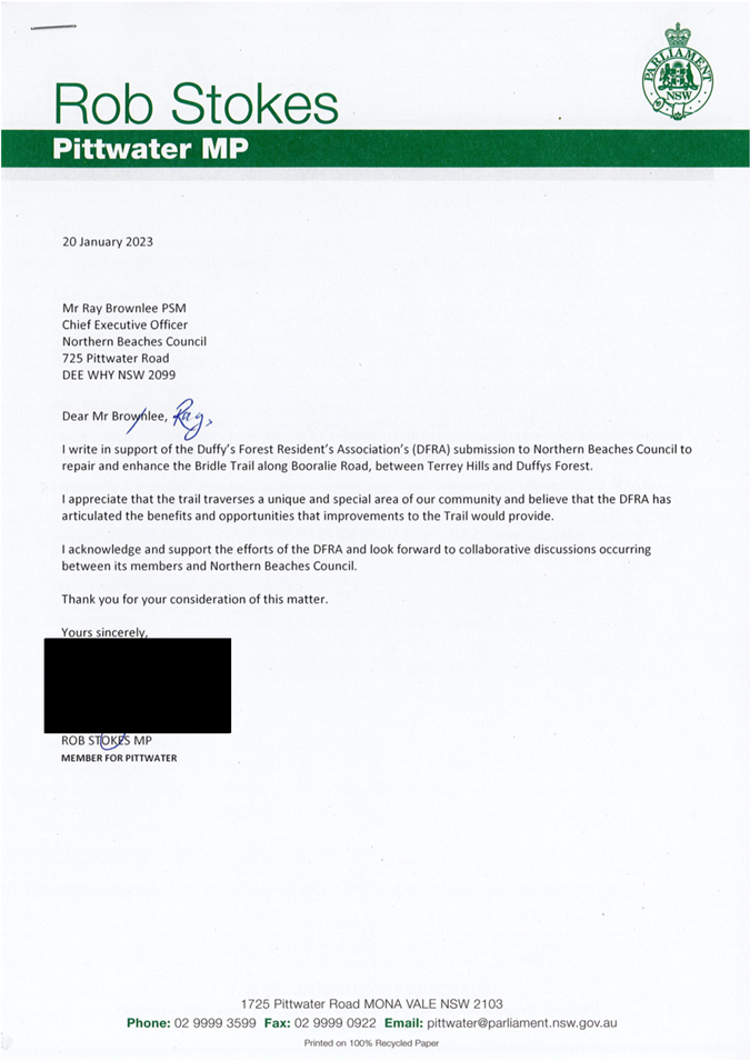
|
|
Attachment 2
NBCS Letter of Support to Council - Duffys Forest and
Terrey Hills Community Bridle Trail
|
|
ITEM NO. 15.7 - 28
February 2023
|
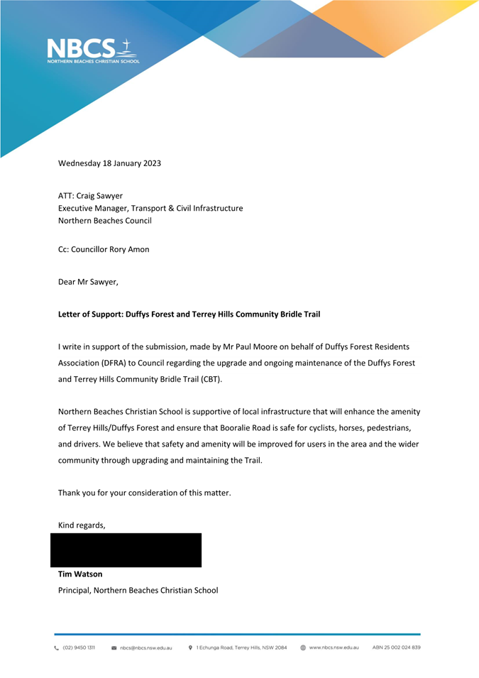
|
|
Report To Ordinary Council MEETING
|
|
ITEM NO. 15.8 - 28 February 2023
|
|
ITEM 15.8
|
Notice
of Motion No 5/2023 - Daydream Street, Warriewood
|
|
TRIM
file REF
|
2023/101065
|
|
ATTACHMENTS
|
NIL
|
Submitted by:
Councillor Rory Amon
That Council write to Transport for NSW
seeking advice as to the detailed reasons why Daydream Street, Warriewood, is
proposed to remain closed onto Mona Vale Road moving forward.
BACKGROUND FROM
COUNCILLOR Rory
Amon
Daydream Street, Warriewood, intersects
with Mona Vale Road, but has been closed off.
Residents have been attempting to
understand why the road is proposed to remain closed following the completion
of the Mona Vale Road (East) duplication but have been unable to receive
reasons from the project managers or Transport for NSW (TfNSW) as to the
reasons why the road is proposed to remain closed.
The purpose of this motion is for Council
to write to TfNSW and seek formal advice and reasons for the proposal for
Daydream Street to remain closed.
|
|
Report To Ordinary Council MEETING
|
|
ITEM NO. 16.1 - 28 February 2023
|
16.0 Questions with Notice
|
ITEM 16.1
|
Question
With Notice No 1/2023 - Footpath, Seaview Road, Mona Vale
|
|
TRIM
file REF
|
2022/829292
|
|
ATTACHMENTS
|
NIL
|
Submitted by: Councillor Rory Amon
QUESTION
I refer to request for a footpath on the eastern side of Surfview
Road, Mona Vale, to form a part of the Coast Walk and to address safety and
amenity issues.
1. The Ocean Beaches Plan of Management - Mona Vale does not
specifically prohibit a footpath encroaching in the dune area (it is not listed
on the page marked number 79 / page 12 of the published Plan of Management).
Could staff please advise whether a footpath could be completed on the eastern
side of Surfview Road, Mona Vale, without a need to amend/create a new Plan of
Management? If the Plan of Management would need to be amended, could staff
please advise why that is the case?
2. If the Plan of Management does need to be amended, could staff
please advise when this can occur and what the associated timelines would be.
|
|
Report To Ordinary Council MEETING
|
|
ITEM NO. 16.2 - 28 February 2023
|
|
ITEM 16.2
|
Question
With Notice No 2/2023 - GIPA Applications
|
|
TRIM
file REF
|
2023/083109
|
|
ATTACHMENTS
|
NIL
|
Submitted by: Councillor Vincent De Luca
OAM
QUESTION
I refer to a recent email dated 5 January 2023 from Council’s
Information Access Officer to a constituent which states:
“My apologies for the delay in responding to your request -
due to the high volume of information requests that Council received last year,
there have been delays in responding within our usual timeframes.”
In view of this, could I please be advised on the following:
1. How many Council Officers were responsible for processing applications
made to Council under GIPA in 2021, 2022 and currently in 2023?
2. In each respective year 2019, 2020, 2021 and 2022
how many Formal and Informal Applications were
received by Council?
3. Between 2019 to 2022 how many applications under
GIPA were refused by Council?
4. Between 2019 to 2022 how many determinations on
GIPA applications were subject to external review applications to the NSW
Information and Privacy Commission and of those, how many did the
Commission recommend Council review or change its decision?
5. Between 2019 to 2022 how many determinations on
GIPA applications were subject to Appeal to NCAT and of those, how many
Appeals were upheld by the Tribunal?
6. Between 2019 to 2022 what is the total amount of
fees collected by Council for Formal GIPA Applications?
|
|
Report To Ordinary Council MEETING
|
|
ITEM NO. 16.3 - 28 February 2023
|
|
ITEM 16.3
|
Question
With Notice No 4/2023 - Dog Access at Cabbage Tree Bay Aquatic Reserve at the
Bower in Manly
|
|
TRIM
file REF
|
2023/117587
|
|
ATTACHMENTS
|
NIL
|
Submitted by: Councillor Candy Bingham
QUESTION
What can be done to prevent dogs from
accessing the rock platforms and swimming in the water at the highly sensitive
and protected marine environment of Cabbage Tree Bay Aquatic Reserve at the
Bower in Manly?
|
|
Report To Ordinary Council MEETING
|
|
ITEM NO. 17.1 - 28 February 2023
|
17.0 Responses to Questions With
Notice
|
ITEM 17.1
|
Response
to Question With Notice No 22/2022 - Development Application Outcomes for
Former Pittwater Local Government Area
|
|
TRIM
file REF
|
2022/727501
|
|
ATTACHMENTS
|
NIL
|
Submitted by:
Councillor Miranda Korzy
QUESTION
1. How many Development Applications (DAs) has
Northern Beaches Council received for the former Pittwater Council area since
2016?
2. How many of these DAs has Council
supported?
3. How many of these DAs has Council opposed
through to the Land and Environment Court?
4. How many of these resulted in the court
rejecting the DA?
5. How many resulted in a negotiated outcome?
RESPONSE
1. Northern Beaches Council was proclaimed on 12 May 2016. Since
13 May 2016, Northern Beaches Council has received 3,842 Development
Applications submitted under Pittwater LEP 2014.
2. Of
the 3,842 Development Applications submitted, 3,709 were
approved.
3. 54 Class 1 appeals were lodged with the Land
and Environment Court relating to Development Applications submitted under
Pittwater Local Environmental Plan 2014. 4 Class 1 appeals are currently
ongoing.
4. 5
Class 1 appeals were dismissed by the Court.
5. 30
Development Applications subject to Class 1 appeal were approved by way of
‘section 34 agreement’ following the applicant submitting
additional information or amended plans to the Court to address Council’s
contentions.
|
|
Report To Ordinary Council MEETING
|
|
ITEM NO. 17.2 - 28 February 2023
|
|
ITEM 17.2
|
Response
to Question With Notice No 23/2022 - Grandview Drive, Seaview Avenue, Newport
- Traffic Changes
|
|
TRIM
file REF
|
2022/782470
|
|
ATTACHMENTS
|
Nil
|
Submitted by: Councillor Rory Amon
QUESTION
Could Council staff review the feedback and
comments by residents (circulated to staff) on the traffic changes made to
Grandview Drive and Seaview Avenue, Newport and provide a report back to the
February 2023 meeting of Council about what steps can be taken to improve the situation,
noting the resident feedback, including but not limited to, considering:
1. What other measures can be taken to improve safety along the route
2. Relocating some or all of the speedbumps
3. Addressing concerns about the slipperiness of the bumps in the wet
4. Whether some or all the current speedbumps on the uphill lane are
required
5. Other matters raised by residents.
RESPONSE
1. Council staff have undertaken a review of the works undertaken and
the road environment in general and found the location is subject of an
existing 40km/h speed limit and a restriction on vehicles over 3 tonne Gross
Vehicle Mass (GVM).
Additional works to improve
safety may include additional resurfacing works with high frictional asphalt,
further restrictions on trucks using Grandview Drive, increased or enhanced
line marking, and potentially additional medians to allow for the removal of
the uphill speed cushions.
2. There are two speed cushions on the uphill section that are being
reviewed to determine what other options could achieve the required road safety
benefits. The cushion location near 55 Grandview Drive would require the installation
of a median to allow it to be removed and prevent vehicles driving on the
incorrect side of the road to avoid the downhill cushion. The other
location near 87 Grandview Drive is being reviewed to potentially have the
rubber cushion removed and replaced with an asphalt speed hump instead to
reduce the loss of traction issues being reported by the community.
3. The speed cushions used along this section of Grandview Drive comply
with the requirements under the approval to use on public roads, however some
drivers have reported issues with them being slippery to drive over resulting
in a loss of traction. Staff are monitoring the speed cushions regularly
to determine the extent of the issue and what part driver behaviour plays in
the loss of traction issue.
4. The pre-installation assessment indicated that the average uphill
speed was 46km/h with the peak speed exceeding 80km/h and 32% of all vehicles
exceeding the posted speed limit of 40km/h. The downhill speed data was only
marginally worse with the average downhill speed of 48km/h, a peak speed
exceeding 90km/h and 45% of all vehicles exceeding the posted speed limit.
Based on the data there needs to
be measures in place to mitigate the uphill traffic speeds as much as the
downhill speeds.
Council will undertake further
consultation with affected residents to gauge their views on removing uphill
speed humps and putting in a median strip at those locations, for road safety.
5. Staff are looking at the overall pavement condition of Grandview Drive
and what additional works is required. The road is not suitable for large
vehicles to use as a route to Bilgola Plateau and this concern has been relayed
to the NSW Police Highway Patrol for increased policing along with the speed
information to assist in improving the safety of the length of road.
TfNSW recorded Accident details:
· March 2016 – minor injury head on near Sybil Street
intersection
· August 2016 – serious injury near 79 Grandview Drive
· December 2017 – serious injury near 130 Grandview Drive
· March 2017 – moderate injury near 18 Grandview Drive
· October 2018 – minor injury head on near Sybil Street
intersection.
Blackspot funding
applications are assessed by TfNSW using data collected by them from police
crash reports and self-reported incidents. Council can provide additional
details to support the application. These locations have been on
Council’s list to address the safety concerns for some time prior to
funding being allocated through the Federal Government Blackspot program.
These
applications are provided to TfNSW up to 3 years prior to funding being
provided and are assessed against a range of other projects in the Greater
Sydney region and funded based on an extensive risk prevention and cost benefit
analysis basis.
|
|
Report To Ordinary Council MEETING
|
|
ITEM NO. 17.3 - 28 February 2023
|
|
ITEM 17.3
|
Response
to Question Taken on Notice No 2/2023 - SEPP Background
|
|
TRIM
file REF
|
2023/052125
|
|
ATTACHMENTS
|
NIL
|
Taken on notice at the Extraordinary
Council meeting on 24 January 2023 from: Councillor Vincent De Luca OAM
QUESTION
Could Council staff please outline when the SEPP was introduced in
relation to this matter and the objectives of the SEPP?
Is it correct that the SEPP was introduced to overcome prejudice to
the indigenous community and ensure that proposals by the indigenous community
were dealt with by impartial and expert opinion?
RESPONSE
Could Council staff please outline when
the SEPP was introduced in relation to this matter and the objectives of the
SEPP?
State Environmental Planning Policy
(Planning Systems) 2021 (Planning Systems SEPP) commenced on 1 March 2022.
The Planning Systems SEPP consolidates and
repeals the provisions of the following 3 SEPPs:
1. SEPP (State and Regional Development)
2011 (State and Regional Development SEPP)
2. SEPP (Aboriginal Land) 2019 (Aboriginal
Land SEPP) (commenced 6 February 2019)
3. SEPP (Concurrences and Consents) 2018
(Concurrence SEPP).
The aims of Chapter 3 - Aboriginal land of
the Planning Systems SEPP are –
(a) to provide for development
delivery plans for areas of land owned by Aboriginal Land Councils to be
considered when development applications are considered, and
(b) to declare specified development
carried out on land owned by Aboriginal Land Councils to be regionally
significant development.
Is it correct that the SEPP was
introduced to overcome prejudice to the indigenous community and ensure that
proposals by the indigenous community were dealt with by impartial and expert
opinion?
The introduction to the Aboriginal Land
SEPP Guideline, prepared by the Department of Planning in 2020, provides the
following commentary on the need for the SEPP and related requirements:
The Aboriginal Land Rights Act 1983 (ALR
Act) was passed by the NSW Parliament to transfer land rights to the Aboriginal
people of NSW as compensation for the loss and dispossession of their land. The
ALR Act recognises the traditional ownership and occupation of the land, and
that land is of spiritual, social, cultural and economic importance to
Aboriginal people.
The NSW Aboriginal Land Council and a
network of 120 Local Aboriginal Land Councils (LALCs) were established to
acquire and manage land as an economic base for Aboriginal people, laying the
basis for a self-reliant and more secure economic future.
Since the establishment of the ALR Act,
LALCs have faced difficulty in creating economic development opportunities from
claimed land. In order to use successfully claimed land for economic purposes,
LALCs are often required to navigate the planning system to have land zoning
and planning controls reconsidered and to have development applications
approved. This can be particularly challenging for LALCs when upfront
investment and expertise is required to engage with the planning system.
LALCs are unique and significant
landowners with cultural, social and economic interests and responsibilities.
They operate under different rules and have different responsibilities than
others who seek to develop their land. Despite this, they are subject to the
same planning processes and assessment criteria as any other landowner, in
addition to processes required under the ALR Act. This magnifies difficulties,
particularly for LALCs with limited resources and capacity to engage with the
NSW planning system.
In response to this challenge, the NSW
Government has released the Aboriginal Land Planning Framework to help LALCs
across NSW better utilise their land. The Framework aligns the NSW planning
system with the ALR Act to support better governance, strategic planning and more
efficient use of land.
The Framework is a comprehensive set of
planning measures to strengthen the economic self-determination of Aboriginal
communities and achieve better social and economic outcomes from their land.
|
|
Report To Ordinary Council MEETING
|
|
ITEM NO. 17.4 - 28 February 2023
|
|
ITEM 17.4
|
Response
to Question With Notice No 3/2023 - NSW Ombudsman Report - 2021-22
Northern Beaches Council Complaints Breakdown
|
|
TRIM
file REF
|
2023/083203
|
|
ATTACHMENTS
|
NIL
|
Submitted by: Councillor Vincent De Luca
OAM
QUESTION
NSW Ombudsman Report and Sydney Morning
Herald article - 29 January 2023 - Northern Beaches Council 3rd most complained
about Council in NSW
Of the 66 complaints received by the NSW
Ombudsman in 2021-22 how many were for:
a. Maladministration
b. Development
Applications/Consents
c. Compliance
issues
d. Council
staff conduct
e. Other
RESPONSE
The NSW Ombudsman has not
provided a breakdown of complaints finalised by category as contemplated by the
above question.
Whilst Northern Beaches Council
was ranked third in relation to the number of complaints finalised by the NSW
Ombudsman, once population is accounted for (complaints per 100,000 residents),
Northern Beaches Council was ranked seventh within the top ten Councils
identified in the NSW Ombudsman report. It is likely that Northern Beaches
Council would be further down the list of Councils for complaints per 100,000
residents if the NSW Ombudsman reported this data for all Councils.
Importantly, of the 66
complaints finalised by the NSW Ombudsman, 50 were finalised following
assessment by the NSW Ombudsman without needing to take further action
(unsubstantiated).
Of the remaining 16 complaints,
the NSW Ombudsman referred 12 to Council for investigation. This occurs where
the NSW Ombudsman determines that Council has not been given a sufficient
opportunity to address the complaint itself.
The remaining f4 complaints
were finalised by the NSW Ombudsman after it took further action. Further
action may include contact with Council and/or the complainant.
Council recorded 18 Ombudsman
complaints during this same time period. The difference in the number of
complaints (2) is due to timing differences between receipt and consideration
of complaints by the NSW Ombudsman and receipt and consideration of complaints
by Council.
Of the 18 Ombudsman complaints
recorded by Council during the 2021-22 financial year, 2 were substantiated.
Both related to early collection of waste bins by URM. 2 others were partially
substantiated. The remaining 14 were unsubstantiated.
In summary, of the 66
complaints finalised by the NSW Ombudsman in 2021/22, 2 were substantiated and
another 2 were partially substantiated. All others were unsubstantiated.
|
|
REPORT TO Ordinary Council Meeting
|
|
ITEM NO. 18.0 - 28 February 2023
|
18.0 matters proposed
to take place in closed session
|
RECOMMENDATION
That:
1. In
accordance with the requirements of section 10A of the Local Government Act
1993 as addressed below, Council resolve to close the meeting to the public
to consider and discuss:
a. Item 18.1 Exemption from Tendering for Provision of
Groceries for Children's Services, Glen Street Theatre and the NSW Rural Fire
Service on the basis that it involves the receipt and discussion of commercial
information of a confidential nature that would, if disclosed, prejudice the
commercial position of the person who supplied it [10A(2)(d(i)) Local
Government Act 1993].
This report discusses/provides
advice concerning the request for exemption from tendering of the ongoing
supply of groceries for Children's Services, Glen Street Theatre and the NSW
Rural Fire Service. On balance, the public interest in preserving the
confidentiality of the information about the matter outweighs the public
interest in maintaining openness and transparency in Council decision-making
because the disclosure of this information would result in the release of
commercial in confidence information.
b. Item 18.2 RFT 2022/109 - Software Provider for Children's
Services Tender Outcome on the basis that it involves the receipt and
discussion of commercial information of a confidential nature that would, if
disclosed, prejudice the commercial position of the person who supplied it
[10A(2)(d(i)) Local Government Act 1993].
This report discusses/provides
advice concerning commercial tenders. On balance, the public interest in
preserving the confidentiality of the information about the matter outweighs
the public interest in maintaining openness and transparency in Council
decision-making because the disclosure of this information would result in
the release of commercial in confidence information.
c. Item 18.3 RFT 2022/224 - Manly Dam Link Trail Boardwalk
on the basis that it involves the receipt and discussion of commercial
information of a confidential nature that would, if disclosed, prejudice the
commercial position of the person who supplied it [10A(2)(d(i)) Local
Government Act 1993].
This report discusses/provides
advice concerning commercial tenders. On balance, the public interest in
preserving the confidentiality of the information about the matter outweighs
the public interest in maintaining openness and transparency in Council
decision-making because the disclosure of this information would result in
the release of commercial in confidence information.
d. Item 18.4 RFT 2022/100 - Irrigation Maintenance Services
on the basis that it involves the receipt and discussion of commercial
information of a confidential nature that would, if disclosed, prejudice the
commercial position of the person who supplied it [10A(2)(d(i)) Local
Government Act 1993].
This report discusses/provides
advice concerning commercial tenders. On balance, the public interest in
preserving the confidentiality of the information about the matter outweighs
the public interest in maintaining openness and transparency in Council
decision-making because the disclosure of this information would result in
the release of commercial in confidence information.
e. Item 18.5 Response to Notice of Motion No 38/2022 - Soft
Plastics Recycling on the basis that it involves the receipt and discussion
of information that would, if disclosed, confer a commercial advantage on a
person with whom the Council is conducting (or proposes to conduct) business
[10A(2)(c) Local Government Act 1993].
This report discusses/provides
advice concerning options for soft plastics recycling. On balance, the public
interest in preserving the confidentiality of the information about the
matter outweighs the public interest in maintaining openness and transparency
in Council decision-making because the disclosure of this information would
confer a commercial advantage on a person with whom Council is conducting (or
proposes to conduct) business.
f. Item 18.6 Minutes of the Property Steering Committee Meeting
held on 28 July 2022 and 21 September 2022. on the basis that it involves the
receipt and discussion of commercial information of a confidential nature
that would, if disclosed, confer a commercial advantage on a competitor of
the council [10A(2)(d(ii)) Local Government Act 1993].
This report discusses/provides
advice concerning Council assets. On balance, the public interest in
preserving the confidentiality of the information about the matter outweighs
the public interest in maintaining openness and transparency in Council
decision-making because the disclosure of this information would provide
commercial information to parties that, if disclosed, would place them at a
commercial advantage.
g. Item 18.7 Facilitating a Group Power Purchase Agreement
for Northern Beaches Businesses on the basis that it involves the receipt and
discussion of information that would, if disclosed, confer a commercial
advantage on a person with whom the Council is conducting (or proposes to
conduct) business [10A(2)(c) Local Government Act 1993].
This report discusses/provides
advice concerning commercial proposals. On balance, the public interest in
preserving the confidentiality of the information about the matter outweighs
the public interest in maintaining openness and transparency in Council
decision-making because the disclosure of this information would result in
the release of commercial in confidence information.
2. The
resolutions made by the Council in Closed Session be made public after the
conclusion of the Closed Session and such resolutions be recorded in the
Minutes of the Council Meeting.
|
19.0 report of
resolutions passed in closed session
|
In accordance with Part 15 of the
Code of Meeting Practice, resolutions passed during a meeting, or a part of a
meeting, that is closed to the public must be made public by the chairperson
as soon as practicable. The resolution must be recorded in the publicly
available minutes of the meeting.
|