Agenda
Notice is hereby given that an Ordinary Meeting of
Council will be held at the Civic Centre, Dee Why on
Tuesday 28 March 2023
Beginning at 6:00pm for the purpose of considering and
determining matters included in this agenda.

Louise Kerr
Interim Chief
Executive Officer
OUR VISION
Delivering the
highest quality service valued and trusted by our community
OUR VALUES
Trust Teamwork
Respect Integrity Service Leadership
OUR OBLIGATIONS
I swear/solemnly
and sincerely declare and affirm that I will undertake the duties of the office
of councillor in the best interests of the people of the Northern Beaches and
the Northern Beaches Council and that I will faithfully and impartially carry out
the functions, powers, authorities and discretions vested in me under the Local
Government Act 1993 or any other Act to the best of my ability and judgement.
1.0 ACKNOWLEDGEMENT
OF COUNTRY
2.0 Apologies and applications for leave of
absence and remote attendance
3.0 Confirmation of Minutes of Previous Meetings
3.1 Minutes of
Ordinary Council Meeting held 28 February 2023..................................... 4
4.0 disclosures of interest
5.0 Public Forum AND PUBLIC ADDRESS
6.0 Items Resolved by Exception
7.0 Mayoral Minutes
Nil
8.0 Chief Executive Officer's Division Reports............................................. 9
8.1 Northern
Beaches Council Discretionary Fund Quarterly Report................................ 9
9.0 Corporate and Legal Division Reports.................................................. 13
9.1 Power
of Attorney Arrangements for Interim Chief Executive Officer....................... 13
9.2 Recruitment
of Independent Member of Audit, Risk and Improvement Committee.. 18
9.3 Minutes
of the Audit, Risk and Improvement Committee Meetings held on 6 December 2022............................................................................................................................ 20
9.4 Suspension
of Alcohol Free Zone for Taste of Manly 2023....................................... 22
9.5 Monthly
Investment Report - February 2023............................................................. 26
10.0 Community and Belonging Division Reports......................................... 38
10.1 Community
Safety Advisory Committee - Confirmed Minutes of 24 November 2022 Meeting....................................................................................................................... 38
10.2 Funding
Review of the Social Services Sector.......................................................... 40
11.0 Environment and Sustainability Division
Reports
Nil
12.0 Planning and Place Division Reports....................................................... 48
12.1 Planning
Proposal 10-12 Boondah Road, Warriewood PEX2022/0001
(deferred from 28 February
2023 Council meeting).......................................................... 48
12.2 Planning
Proposal for 6 Mitchell Road, Palm Beach - PEX2022/0003
(deferred from 28 February
2023 Council meeting).......................................................... 77
12.3 Public
Exhibition of Draft Planning Agreement at 321-331 Condamine Street, Manly Vale.................................................................................................................................... 99
12.4 Adoption
of Draft Council- related Development Applications Policy...................... 108
12.5 Variations
to Development Standards Under Clause 4.6 of Local Environmental Plans.................................................................................................................................. 123
13.0 Transport and Assets Division Reports............................................... 135
13.1 Response
to Notice of Motion No 36/2022 - Potholes on Local Roads
(deferred from 28 February
2023 Council meeting)........................................................ 135
13.2 Proposed
Easement to Drain Water Over Fox Reserve, Collaroy to Benefit 41 and 43 Beach
Road, Collaroy............................................................................................... 138
13.3 Public
Exhibition of a Proposal for a New Community Garden at Annam Road Reserve,
Bayview.................................................................................................................... 144
13.4 Outcome
of Community Engagement - Market Lane Waste Facility Access Fee.. 149
14.0 Workforce and Technology Division Reports
Nil
15.0 Notices of Motion............................................................................................ 158
15.1 Notice
of Motion No 1/2023 - Parking Restrictions Request, Pittwater Road, Collaroy (deferred from 28 February 2023 Council
meeting)........................................................ 158
15.2 Notice
of Motion No 2/2023 - Beach Safety Signs
(deferred from 28 February
2023 Council meeting)........................................................ 159
15.3 Notice
of Motion No 3/2023 - Cashless Gaming Card Reform
(deferred from 28 February
2023 Council meeting)........................................................ 162
15.4 Notice
of Motion No 6/2023 - Brewarrina Sister City Youth Program
(deferred from 28 February
2023 Council meeting)........................................................ 163
15.5 Notice
of Motion No 7/2023 - Urgent Request for a Safety Audit of Electric Bike,
Electric Scooter and Other Bike Usage on Northern Beaches Shared Paths, Bike
Paths and Footpaths
(deferred from 28 February
2023 Council meeting)........................................................ 164
15.6 Notice
of Motion No 4/2023 - Duffys Forest Community Bridle Trail
(deferred from 28 February
2023 Council meeting)........................................................ 166
15.7 Notice
of Motion No 5/2023 - Daydream Street, Warriewood
(deferred from 28 February
2023 Council meeting)........................................................ 169
15.8 Notice
of Motion No 9/2023 - Building and Development Compliance................... 170
15.9 Notice
of Motion No 10/2023 - Warringah Aquatic Centre Adult Swim Classes..... 173
16.0 Questions with Notice................................................................................... 175
16.1 Question
With Notice No 5/2023 - Manly's Little Penguins..................................... 175
16.2 Question
With Notice No 6/2023 - Brookvale Structure Plan - Night Clubs............ 176
16.3 Question
With Notice No 7/2023 - Brookvale Structure Plan - Increased Development and
Lack of Transport Infrastructure to Cope.......................................................... 177
17.0 Responses to Questions With Notice..................................................... 178
17.1 Response
to Question Taken on Notice No 1/2023 - Lizard Rock Second Opinion Legal
Costing...................................................................................................................... 178
17.2 Response
to Question With Notice No 2/2023 - GIPA Applications....................... 179
18.0 matters proposed to take place in closed
session...................... 181
18.1 RFT
2022/125 - Lease of Cafe/Restaurant - Flying Fox Cafe
18.2 Exemption
from Tendering for Provision of Maintenance of Parking Equipment and Software
for the Manly Pay Stations
19.0 Report of Resolutions Passed in Closed Session
|

|
Ordinary Council Meeting
|
|
28 March 2023
|
1.0 ACKNOWLEDGEMENT OF COUNTRY
|
As a sign of
respect, Northern Beaches Council acknowledges the traditional custodians of these
lands on which we gather and pays respect to Elders past and present.
|
2.0 Apologies AND applications for leave of
absence AND REMOTE ATTENDANCE
|
In accordance
with Part 6 of the Code of Meeting Practice, Council will consider apologies,
requests for leave of absence, and requests to attend meetings remotely via
audio-visual link.
|
3.0 Confirmation
of minutes
3.1 Minutes
of Ordinary Council Meeting held 28 February 2023
|
Recommendation
That the minutes of the Ordinary Council Meeting
held 28 February 2023, copies of which were previously circulated, be
confirmed as a true and correct record of the proceedings of that meeting.
|
4.0 disclosures of interest
|
In accordance
with Part 17 of the Code of Meeting Practice, all Councillors must disclose
and manage any conflicts of interest they may have in matters being
considered at the meeting.
A Councillor who
has a pecuniary interest in any matter with which Council is
concerned, and who is present at a meeting of Council at which the matter is
being considered, must disclose the nature of the interest to the meeting as
soon as practicable.
The Councillor
must not be present at, or in sight of, the meeting:
a.
at any time during which the matter is being considered or discussed,
or
b.
at any time during which Council is voting on any question in relation
to the matter.
A Councillor who
has a significant non-pecuniary conflict of interest in a matter under
consideration at a Council meeting, must manage the conflict of interest as
if they had a pecuniary interest in the matter.
A Councillor who
determines that they have a non-pecuniary conflict of interest in a matter
that is not significant and does not require further action, when
disclosing the interest must also explain why the conflict is not significant
and does not require further action in the circumstances.
As required by
Council’s Code of Conduct and the Information and Privacy
Commission’s Information Access Guideline 1, returns made by designated
persons are routinely tabled at Council meetings and published on
Council’s website.
|
5.0 Public Forum AND PUBLIC ADDRESS
|
In accordance
with Part 5 of the Code of Meeting Practice, residents, ratepayers,
applicants or other persons may request to address Council in relation to any
one matter related to the general business of Council but not the subject of
a report on the agenda (Public Forum) and no more than two matters listed for
consideration on the agenda (Public Address).
|
6.0 Items Resolved by EXCEPTION
|
In accordance
with Part 14 of the Code of Meeting Practice, items that are dealt with by
exception are items where the recommendations contained in the staff reports
in the agenda are adopted without discussion.
|
|
|
Report To Ordinary Council MEETING
|
|
ITEM NO. 8.1 - 28 March 2023
|
8.0 Chief Executive
Officer's Division Reports
liahr
|
ITEM 8.1
|
Northern
Beaches Council Discretionary Fund Quarterly Report
|
|
REPORTING
MANAGER
|
INTERIM
Chief Executive Officer
|
|
TRIM
file REF
|
2023/157300
|
|
ATTACHMENTS
|
Nil
|
purpose
To provide a report on the recipients and projects
that have received an allocation from the Northern Beaches Council
Discretionary Fund during the past quarter.
executive summary
The Northern Beaches Council Discretionary
Fund provides the opportunity for Councillors to put forward requests from
individuals and community organisations for financial assistance towards
initiatives and services which benefit the local community or provide
assistance to local residents.
Payments made for the period 7 December
2022 to 21 March 2023 totaling $5,600.00 are listed below.
|
Recipient
|
Description
|
Allocation
|
|
Koori Kids Pty Ltd – NAIDOC Week Schools Initiative
|
Financial assistance towards the 2023 Schools Initiative
offered to local primary schools
|
$500.00
|
|
Rotary Club of North Sydney Inc.
|
Sponsorship for 5 children with special needs who attend
Fisher Road Public School and their carers to attend the World Festival of
Magic – funds also raised for Phoenix House and Royal Far
West
|
$600.00
|
|
Dee Why Ladies Amateur Swimming Club
|
Financial assistance towards the Dee Why Ladies Amateur
Swimming Club – 100th Year celebrations held on 4 February
2023
|
$1,000.00
|
|
Special Olympics Sydney Northern Beaches
|
Contribution towards the Judy Buckley Memorial Golf
Charity Day on 24 February 2023 – raising funds for people with an
intellectual disability to participate in year-round sports and competitions
|
$1,000.00
|
|
Balgowlah Suns Junior AFL Club Inc.
|
Contribution towards the Balgowlah Suns Big Freeze Charity
Event to be held in June 2023 – raising funds for Motor Neurone Disease
(MND) research
|
$1,000.00
|
|
Local residents *
|
Financial assistance for 2 residents from the same family
to represent Australia in the U19 Men’s World Floorball Championships
in Denmark in April 2023
(note – total of 3 local residents
were selected in the team)
|
$1,000.00
|
|
Local resident *
|
Financial assistance for local resident to represent
Australia in the U19 Men’s World Floorball Championships in Denmark in
April 2023
(note – total of 3 local residents
were selected in the team)
|
$500.00
|
* individual recipients’
details are not included in this report for privacy reasons. All
residents in receipt of funds are verified as residents of the Northern
Beaches.
The next Northern Beaches Council Discretionary Fund
quarterly report will be provided at the Ordinary Council meeting on 27 June
2023.
RECOMMENDATION OF INTERIM Chief Executive Officer
That Council note payments totalling $5,600.00 have been
allocated from the Northern Beaches Council Discretionary Fund for the period 7
December 2022 to 21 March 2023.
BACKGROUND
The Northern Beaches Council Discretionary Fund Policy
supports individuals and community organisations through small financial
donations. It also provides assistance to local residents to attend events or
conferences that further develop educational or sporting endeavours at a
representative level.
The Northern Beaches Council Discretionary Fund Policy
requires recipient and project details to be reported to Council on a quarterly
basis. This report only includes allocations that have been finalised.
As required under the policy, the maximum amount which may
be allocated to an individual or community organisation is $1,000 and only one
payment can be made to an individual or community organisation within the same
financial year.
All requests to the Northern Beaches Council Discretionary
Fund are submitted to the Mayor, Deputy Mayor or a Councillor, and the Chief
Executive Officer to certify that the allocation is made in accordance with the
policy and that the funds are available.
CONSULTATION
Requests upon the discretionary fund are submitted to the
Mayor, Deputy Mayor or Councillor and the Chief Executive Officer for approval
in accordance with the policy.
TIMING
A quarterly report to Council is required by the Northern
Beaches Council Discretionary Fund Policy.
LINK TO STRATEGY
This report relates to the Community
Strategic Plan Outcome of:
· Community and Belonging - Goal 7: Our diverse community is supported
to participate in their chosen cultural life.
· Community and Belonging - Goal 8: Our community feels safe and
supported.
· Participation and Partnership - Goal 22: Our Council builds and
maintains strong partnerships and advocates effectively on behalf of the
community.
financial considerations
The funds allocated are provided within the existing annual
budget of $30,000 for the Northern Beaches Discretionary Fund. Total
expenditure of $12,893.00 is remaining. No funding will be provided
outside of the allocated budget in each financial year. An amount of
$800.00 was included in the total expenditure reported in the Quarterly Report
to Council on 13 December 2022 but not individually listed at the time. This
amount was for a Youth Up Front Charity event which was cancelled. The amount
of $800.00 has been credited to the Discretionary Fund.
social considerations
The Northern Beaches Council Discretionary Fund supports
individuals and community organisations and provides assistance to local
residents to attend events or conferences that further develop their
educational or sporting endeavours at a representative level.
environmental considerations
The Northern Beaches Council Discretionary Fund –
Quarterly Report has no specific environmental impact.
governance and risk
considerations
Payments allocated under the Northern Beaches Council Discretionary
Fund have satisfied the requirements under both the Northern Beaches Council
Discretionary Fund Policy and the approval process as last adopted by Council
on 27 September 2022.
The next Quarterly Report will be provided at the Ordinary
Council meeting on 27 June 2023.
|

|
Report To Ordinary Council MEETING
|
|
ITEM NO. 9.1 - 28 March 2023
|
9.0 Corporate and Legal
Division Reports
|
ITEM 9.1
|
Power
of Attorney Arrangements for Interim Chief Executive Officer
|
|
REPORTING
MANAGER
|
Executive
Manager Governance & Risk
|
|
TRIM
file REF
|
2023/164288
|
|
ATTACHMENTS
|
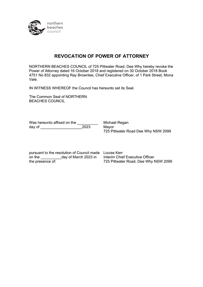
1 ⇩Revocation
of Power of Attorney - Ray Brownlee
2 ⇩Power
of Attorney - Louise Kerr
|
purpose
To revoke the Power of Attorney to Mr Ray
Brownlee, Chief Executive Officer and seek a Power of Attorney for the Interim
Chief Executive Officer, Ms Louise Kerr.
REPORT
On 16 October 2018, Council granted a Power
of Attorney to the Chief Executive Officer, Mr Ray
Brownlee - Power of Attorney (Book 4751 No 832, registered
30 October 2018).
A Power of
Attorney for Ms Louise Kerr, Interim Chief Executive Officer is sought for the
purposes of giving effect to resolutions or functions of the Council where the
use of the Power of Attorney is resolved or required.
LINK TO COUNCIL STRATEGY
This report relates to the Community
Strategic Plan Outcome of Good governance - Goal 19 Our Council is transparent
and trusted to make decisions that reflect the values of the community.
FINANCIAL CONSIDERATIONS
The recommendations of this report pose no
financial impact on Council.
ENVIRONMENTAL CONSIDERATIONS
The recommendations of this report pose no
environmental impact on Council.
Social considerations
The recommendations of this report pose no
social impact on Council.
governance and risk
considerations
The recommendations of this report maintain
consistent governance arrangements while the Chief Executive Officer acting
arrangements are in place.
RECOMMENDATION OF Director Corporate and Legal
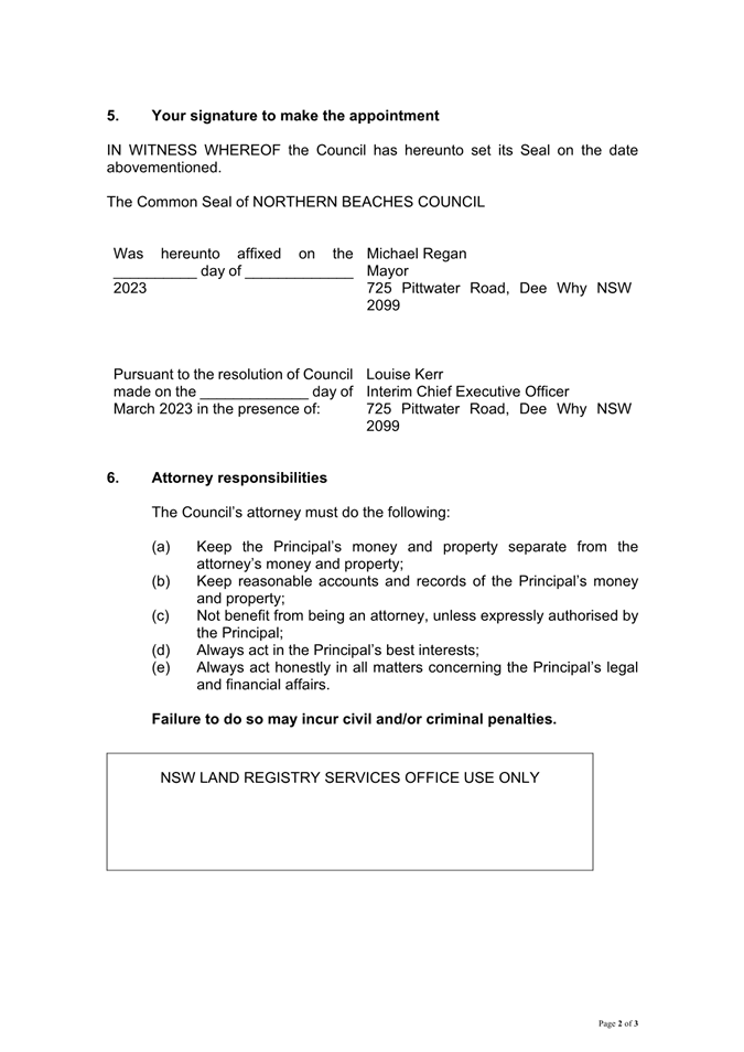
That Council:
1. Revoke
the Power of Attorney Book 4751 No 832, registered on 30
October 2018
2. Affix
the Common Seal of Council to the Revocation of Power of Attorney (Attachment
1)
3. Grant
Power of Attorney to Ms Louise Kerr, Interim Chief Executive Officer effective
on and from 29 March 2023 to execute documents, dealings and instruments
relating to the matters detailed in the draft instrument provided at Attachment
2 to this report
4. Affix
the Common Seal of Council to the Power of Attorney
5. Attend to the registration of the Revocation of Power of Attorney
Book 4751 No 832 and the new Power of Attorney to Ms Louise Kerr.
|

|
Attachment 1
Revocation of Power of Attorney - Ray Brownlee
|
|
ITEM NO. 9.1 - 28 March
2023
|
|
|
Attachment 2
Power of Attorney - Louise Kerr
|
|
ITEM NO. 9.1 - 28 March
2023
|
|
|
Report To Ordinary Council MEETING
|
|
ITEM NO. 9.2 - 28 March 2023
|
|
ITEM 9.2
|
Recruitment
of Independent Member of Audit, Risk and Improvement Committee
|
|
REPORTING
MANAGER
|
Executive
Manager Governance & Risk
|
|
TRIM
file REF
|
2023/150174
|
|
ATTACHMENTS
|
NIL
|
purpose
To select a Councillor representative for
the assessment panel for independent membership of the Audit, Risk and
Improvement Committee (ARIC).
REPORT
A vacancy in the external independent
membership of Council’s ARIC has arisen following the resignation of
Sarah Richardson, effective following the March 2023 ARIC meeting.
In accordance with the ARIC Charter, the
independent external membership of the Committee is determined by resolution of
Council.
An Expression of
Interest (EOI) process has been initiated to identify
and appoint a suitably qualified independent external member to the Committee.
Applications are currently being received and the EOI will close on 10 April
2023.
It is proposed that an assessment panel
consisting of the Interim Chief Executive Officer, Louise Kerr, the current
Chair of the ARIC, Stephen Horne and a Councillor representative be convened to
assess the applications received and make recommendations to Council for the
appointment of the independent member.
Due to the Easter period impacting the
Council meeting schedule, it is anticipated the panel would convene at a
mutually convenient time in April with a report to be brought to the May
ordinary Council meeting for the Council to consider the recommendations and
make an appointment to the ARIC.
The next ARIC meeting is scheduled for 13
June 2023.
LINK TO COUNCIL STRATEGY
This report relates to the Community
Strategic Plan Outcome of:
Good governance - Goal 19 Our Council is
transparent and trusted to make decisions that reflect the values of the
community.
FINANCIAL CONSIDERATIONS
Funding to support the Audit, Risk and
Improvement Committee is included in existing operational budgets.
ENVIRONMENTAL CONSIDERATIONS
The recruitment for an independent member
of the Audit, Risk and Improvement Committee has no environmental impacts.
Social considerations
Council is accountable to the community for
the delivery of the Community Strategic Plan and a key function of the Audit,
Risk and Improvement Committee is to promote good corporate governance,
transparency and external accountability.
governance and risk
considerations
The Audit, Risk and Improvement Committee
(ARIC) plays a pivotal role in the governance framework to provide Council with
independent assurance and assistance in the areas of internal audit, risk
management, compliance and control, governance, organisational performance and
improvement and external accountability responsibilities.
Membership of the ARIC is in accordance
with the Committee Charter, which is based on the guidelines issued by the
Chief Executive of the Office of Local Government pursuant to section 23A of
the Local Government Act 1993. The NSW Government has released
updated Guidelines for Risk Management and Internal Audit for Local Government
in NSW that will outline the operations of ARIC including membership, however
these are yet to be formally supported by regulation.
The Expressions of Interest process and
requirements for the new member have been aligned to meet the current charter
and the new guidelines and ensure the Committee as a whole has a complementary
mix of skills and capabilities.
RECOMMENDATION OF Director Corporate and Legal
That:
1. Council endorse a panel to provide recommendations to Council
following its assessment and evaluation of the Expressions of Interest for
independent membership of the Audit, Risk and Improvement Committee.
2. The panel is to comprise the Interim Chief Executive Officer, the
Chair of the Audit, Risk and Improvement Committee and one Councillor.
|
|
Report To Ordinary Council MEETING
|
|
ITEM NO. 9.3 - 28 March 2023
|
|
ITEM 9.3
|
Minutes
of the Audit, Risk and Improvement Committee Meetings held on 6 December 2022
|
|
REPORTING
MANAGER
|
Executive
Manager Governance & Risk
|
|
TRIM
file REF
|
2022/784877
|
|
ATTACHMENTS
|
1 ⇨Minutes - ARIC - 20221206 (Included In Attachments
Booklet)
|
purpose
To report the confirmed minutes of the
Audit, Risk and Improvement Committee (ARIC) ordinary meeting held on 6
December 2022 (provided at Attachment 1).
REPORT
The ARIC plays a pivotal role providing
Council with independent assurance and advice in the areas of internal audit,
financial management, risk management, compliance and control, organisational
performance, and improvement. In accordance with the ARIC Charter,
confirmed minutes of ARIC meetings are to be reported to Council.
LINK TO COUNCIL STRATEGY
This report relates to the Community
Strategic Plan Outcome of Good Governance - Goal 19: Our Council is transparent
and trusted to make decisions that reflect the values of the community.
FINANCIAL CONSIDERATIONS
Funding to support the Audit, Risk and
Improvement Committee is included in the existing budget.
ENVIRONMENTAL CONSIDERATIONS
There are no environmental impacts in
relation to this report.
Social considerations
There are no social impacts in relation to
this report.
governance and risk considerations
Councils are required to have an ARIC in
accordance with section 428A of the Local Government Act 1993. The ARIC
Charter outlines that a key function of the ARIC is to assess and provide
advice on Council’s governance, compliance and risk
management functions. ARIC’s oversight aims to ensure that appropriate
controls are in place for risk exposures as they relate to the strategic
objectives of Council, and to satisfy itself that Council is taking a fully
informed risk-based approach.
RECOMMENDATION OF Director Corporate and Legal
That
Council note the confirmed minutes of the Audit, Risk and Improvement Committee
ordinary meeting held on 6 December 2022.
|
|
Report To Ordinary Council MEETING
|
|
ITEM NO. 9.4 - 28 March 2023
|
|
ITEM 9.4
|
Suspension
of Alcohol Free Zone for Taste of Manly 2023
|
|
REPORTING
MANAGER
|
Executive
Manager Community Engagement & Communications
|
|
TRIM
file REF
|
2023/127484
|
|
ATTACHMENTS
|
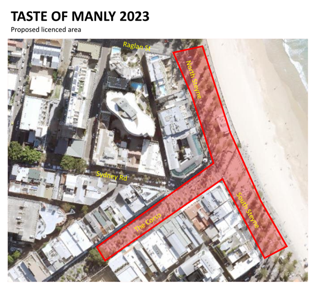
1 ⇩Taste
of Manly 2023 Proposed Licenced Area Map
|
purpose
To suspend the Alcohol Free Zone and Alcohol Prohibited Area
in Manly CBD in specific locations within the event site for the 2023 Taste of
Manly (food and drink festival) to be held on Saturday 27 and Sunday 28 May
2023.
executive summary
Taste of Manly will be held on Saturday 27 and Sunday 28 May
2023 from 11.30am to 5.30pm daily. It is proposed that the Alcohol Free Zone
and Alcohol Prohibited Area in Manly CBD be suspended for the event. Alcohol
has been permitted at this event in recent years without incident.
RECOMMENDATION OF Director Corporate and Legal
That Council:
1. Suspend
operation of the Alcohol Free Zone and Alcohol Prohibited Area for the Taste of
Manly 2023 event only within the designated festival area in Manly on Saturday
27 and Sunday 28 May 2023 between the hours of 11.30am and 5.30pm daily.
2. Provide appropriate notice of the suspension of the Alcohol Free
Zone and Alcohol Prohibited Area, in accordance with s645(i) of the Local
Government Act 1993.
3. Events staff continue to liaise with Police from the Northern
Beaches Local Area Command in relation to safe management of the area during
the suspensions.
BACKGROUND
Taste of Manly will be held on Saturday 27 and Sunday 28 May
2023 from 11.30am to 5.30pm daily. As per the attached map, the festival will
be presented along Manly Beachfront promenade and within a road closure along
North and South Steyne between Raglan Street and Wentworth Street, as well as
along The Corso pedestrian mall from the beachfront to Darley Road.
Given the nature of this event, alcohol will be sold from
designated festival stalls and consumed within the licensed area. This festival
area is situated within the existing Alcohol Free Zone and Alcohol Prohibited
Area in the Manly CBD and as such, persons who consume alcohol
in this area would be committing an offence if Council was not to suspend these
restrictions in the event location for the period of the event.
Under the provisions of section 645(1) of
the Local Government Act 1993, Council “may, at the request of any
person or body or of its own motion, suspend the operation of an alcohol-free
zone by publishing notice of the suspension in a newspaper circulating in the
area as a whole or in a part of the area that includes the zone
concerned”.
The event has been running successfully for
over 30 years. The Events Team continues to liaise with Police from the Local
Area Command Licensing Team in relation to safe management of the area during
the delivery of Taste of Manly.
In response it is recommended that:
· The
operation of the Alcohol Free Zones (The Corso, North Steyne and South Steyne)
and Alcohol Prohibited areas (Manly Beachfront promenade) in the Manly
CBD be suspended on Saturday 27 and Sunday 28 May 2023 from 11.30am to 5.30pm
for the Taste of Manly event.
CONSULTATION
Council has worked and continues to work
closely and successfully with Northern Beaches Police Local Area Command to
ensure the safe operation of the area during the event.
In 2023, Council will
contract Canvas Events to hold and operate the liquor licence on
Council’s behalf. Canvas Events will oversee the operation of the licence
in conjunction with Council’s Events Team and RSA-certified contract
security guards. The Licensee, Events Team and Security Manager will be onsite
throughout the event to liaise with stallholders and authorities to ensure the
responsible service of alcohol and licensing conditions are adhered to.
TIMING
The Alcohol Free Zone (The Corso, North
Steyne and South Steyne) and Alcohol Prohibited Area (Manly
Beachfront promenade) will be suspended in the designated event area
only between the hours of 11.30am and 5.30pm on Saturday 27 and Sunday 28 May
2023. The Alcohol Free Zone and Alcohol Prohibited Area will remain in place
outside of these days, times and locations.
LINK TO STRATEGY
This report relates to the Northern Beaches
Event Strategy 2018 – 2023.
This report also relates to the Community
Strategic Plan Outcome of:
· Community and belonging - Goal 8 Our community feels safe and
supported
· Housing, places and spaces - Goal 11 Our local centres are vibrant
and healthy, catering for diverse economic and social needs
· Partnership and participation - Goal 22 Our Council builds and
maintains strong partnerships and advocates effectively on behalf of the community
financial considerations
All costs associated with the
responsible management of alcohol service have been included in the existing
2023 event budget.
social considerations
The consumption of alcohol will only be
allowed within the approved event site and times. Council will provide
sufficient security personnel to monitor anti-social behaviour and the
responsible service of alcohol. Council will also engage User Pays police to
further monitor the event site.
environmental considerations
Event participants can only consume
alcoholic drinks in the reusable glasses purchased at the event. Council will
provide increased waste services for the festival to manage the disposal of
food, alcohol and other products.
governance and risk
considerations
Alcohol has been permitted at the Taste of
Manly event in recent years without incident. For the 2023 event a range of
risk management measures will be put in place to manage alcohol-related matters
including ID checks, drink limits, no BYO or takeaway sales, and security personnel will be engaged to manage crowd behaviour.
|

|
Attachment 1
Taste of Manly 2023 Proposed Licenced Area Map
|
|
ITEM NO. 9.4 - 28 March
2023
|
|

|
Report To Ordinary Council MEETING
|
|
ITEM NO. 9.5 - 28 March 2023
|
pp
|
ITEM 9.5
|
Monthly
Investment Report - February 2023
|
|
REPORTING MANAGER
|
Chief
Financial Officer
|
|
TRIM file
REF
|
2023/140297
|
|
ATTACHMENTS
|
Nil
|
purpose
To provide a report setting out details of all money that
Council has invested under section 625 of the Local Government Act 1993.
executive summary
In accordance with section 212 of the Local Government
(General) Regulation 2021, a report setting out the details of money invested
must be presented to Council on a monthly basis.
The report must also include certification as to whether or
not the investments have been made in accordance with the Act, the Regulations
and Council’s Investment Policy.
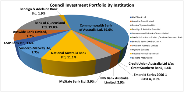
The Investment Report shows that Council has total cash and
investments of $207,336,465 comprising:
|
· Trading Accounts
|
$6,666,848
|
|
· Investments
|
$200,669,617
|
The
portfolio achieved a return of 0.310% for the month of February which was 0.07%
above the benchmark AusBond Bank Bill Index return of 0.24%. For the past 12
months the portfolio achieved a return of 2.306% which was 0.546% above the
benchmark AusBond Bank Bill Index return of 1.76%.
The weighted average interest rate of the portfolio is 4.03%
compared to 3.85% for the prior month. For the past 12 months the weighted
average interest rate of the portfolio was 2.51% compared to the average
Ausbond Bank Bill movement of 0.14% and the average Reserve Bank of Australia
Cash Rate of 1.83%.
Certification –
Responsible Accounting Officer
I hereby certify that the investments listed in the attached
reports have been made in accordance with section 625 of the Local
Government Act 1993, section 212 of the Local Government (General)
Regulation 2021 and existing Investment Policies.
RECOMMENDATION OF Director Corporate and Legal
That Council note the Investment Report as at 28 February
2023, including the certification by the Responsible Accounting Officer.
BACKGROUND
In accordance with section 212 of the Local Government
(General) Regulation 2021, a report setting out the details of money invested
must be presented to Council on a monthly basis.
The report must also include certification as to whether or
not the investments have been made in accordance with the Act, the Regulations
and Council’s Investment Policy.
LINK TO STRATEGY
This report relates to the Community Strategic Plan Outcome
of:
· Good
governance - Goal 19 Our Council is transparent and trusted to make decisions
that reflect the values of the community
financial considerations
Actual investment income for the period from 1 July 2022 to
date was $3,992,915 compared to budgeted income of $409,500, a positive
variance of $3,583,415.
social considerations
Council’s investments are managed in accordance with
Council’s Investment Policy. Council’s Investment Policy requires
consideration of social responsibility when making investment decisions.
environmental considerations
Council’s investments are managed in accordance with
Council’s Investment Policy. Council’s Investment Policy requires consideration
of environmental responsibility when making investment decisions.
governance and risk
considerations
A revised Investment Policy was adopted by Council at its
meeting on 26 July 2022. The Policy is reviewed annually by the Audit, Risk and
Improvement Committee. It was reviewed by the Committee at their meeting in
December 2022, and no changes to the Policy were proposed, with the next review
by the Committee due by December 2023.
Council’s Investment Strategy
was reviewed in November 2022 by Council’s Investment Advisors, Laminar
Capital Pty Ltd, who confirmed that the current policy “remains
consistent with the Ministerial Investment Order and guidelines issued by the
Chief Executive (Local Government), Department of Premier and Cabinet”
and that they “do not recommend any changes to the list of approved
investments or credit limit frameworks”.
Investment Balances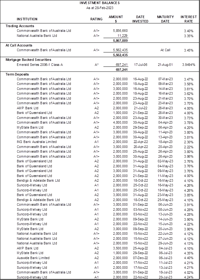

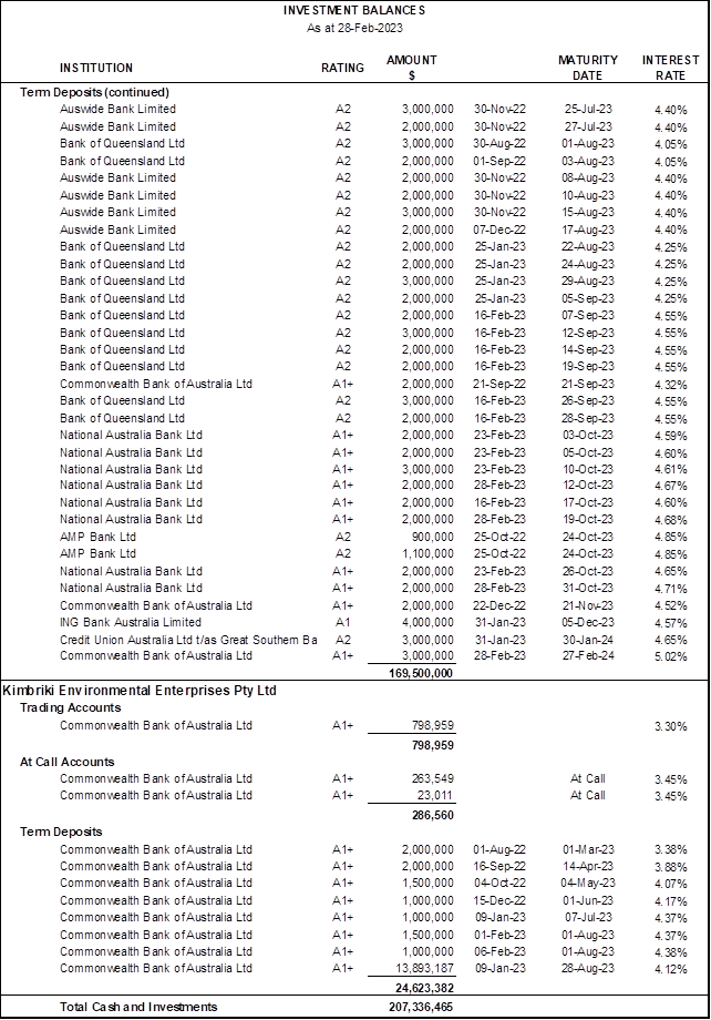
*Rating is based on
a private rating advised by the issuer to Council’s Investment Advisors.
Portfolio Analysis
Institutional Credit Framework – Compliance with Investment
Policy Requirements
Clause 4.2.2 of Council’s Investment Policy requires
that the exposure to an individual institution be restricted by their credit
rating so that single entity exposure is limited, as detailed in the table
below:
|
S&P
Long Term Rating*
|
S&P
Short Term Rating*
|
Maximum %
|
Portfolio
Complies with Policy?
|
|
AAA
(incl. government
guaranteed deposits)
|
A-1+
|
50%
|
Yes
|
|
AA+
|
|
AA
|
|
AA-
|
|
A+
|
A-1
|
40%
|
Yes
|
|
A
|
|
A-
|
A-2
|
30%
|
Yes
|
|
BBB+
|
|
BBB
|
|
BBB-
|
A-3
|
10%
|
Yes
|
|
Unrated**TCorp Funds
|
Unrated**
|
5%
|
Yes ($Nil)
|
|
Unrated***ADIs
|
Unrated***
|
$250,000
|
Yes ($Nil)
|
* Or Moody’s / Fitch equivalents
** Unrated
Category is restricted to eligible managed funds such as the NSW Treasury
Corporation Hour Glass Facilities
*** Unrated
ADIs Category is restricted to those ADIs that are under the Australian
government guarantee scheme and limited to maximum $250,000 per unrated ADI.
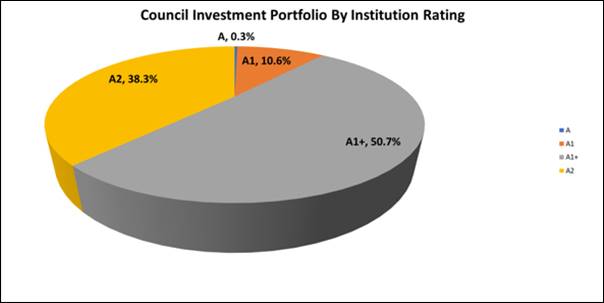
Overall Portfolio Credit Framework – Compliance with Investment
Policy Requirements
Clause 4.2.1 of Council’s Investment Policy requires
that the total percentage exposure within the market to any particular credit
rating category be limited, as detailed in the table below:
|
S&P
Long Term Rating*
|
S&P
Short Term Rating*
|
Maximum %
|
Portfolio
Complies with Policy?
|
|
AAA
(incl. government
guaranteed deposits)
|
A-1+
|
100%
|
Yes
|
|
AA+
|
|
AA
|
|
AA-
|
|
A+
|
A-1
|
100%
|
Yes
|
|
A
|
|
A-
|
A-2
|
80%
|
Yes
|
|
BBB+
|
|
BBB
|
|
BBB-
|
A-3
|
30%
|
Yes
|
|
Unrated**
|
Unrated**
|
5%
|
Yes ($Nil)
|
* Or Moody’s / Fitch equivalents
** Unrated
Category is restricted to eligible managed funds such as the NSW Treasury
Corporation Hour Glass Facilities and ADIs covered by the government guarantee
scheme.
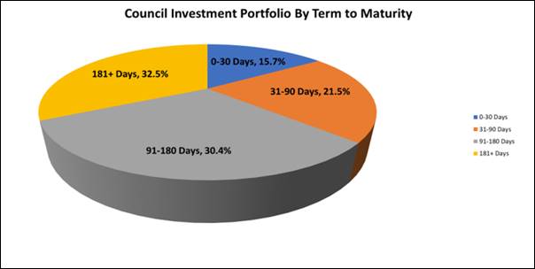
Term to Maturity Framework
– Compliance with Investment Policy Requirements
Clause 4.2.4 of Council’s Investment Policy requires
Council’s investment portfolio is to be invested within the following
maturity constraints:
|
Overall Portfolio Term to Maturity
Limits
|
Portfolio Complies with Policy?
|
|
Portfolio
% <1 year
|
Min 40%
|
Max 100%
|
Yes
|
|
Portfolio
% >1 year ≤3 year
|
Min 0%
|
Max 60%
|
Yes
|
|
Portfolio
% >3 year ≤5 year
|
Min 0%
|
Max 30%
|
Yes
|
Investment
Performance vs Benchmark
a) Portfolio
Return vs Benchmark
|
|
Investment Portfolio Return *
|
Benchmark: AusBond Bank Bill
Index
|
|
1 month
|
0.310%
|
0.24%
|
|
3 Months
|
0.927%
|
0.76%
|
|
FYTD
|
2.047%
|
1.68%
|
|
12 Months
|
2.306%
|
1.76%
|
* Excludes trading account balances
Council’s Investment Advisors have stated this
form of portfolio reporting conforms to global investment performance standards
and that these standards say that periods below 12 months should not be
annualised.
The above table shows a
comparison of Council’s investment portfolio return to the benchmark.
Council’s Investment Advisor, Laminar Capital, has created an
accumulation index for the portfolio which increases each month by the
portfolio internal rate of return to enable meaningful comparison to the
benchmark AusBond Bank Bill index, which is an accumulation index.
The Bloomberg AusBond Bank Bill
Index is engineered to measure the Australian money market by representing a
passively managed short term money market portfolio. This index is comprised of
13 synthetic instruments defined by rates interpolated from the RBA 24-hour
cash rate, 1M BBSW, and 3M BBSW.
The
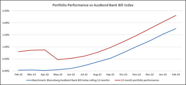
portfolio achieved a return of 0.310% for the month of February which was 0.07%
above the benchmark AusBond Bank Bill Index return of 0.24%. For the past 12
months the portfolio achieved a return of 2.306% which was 0.546% above the
benchmark AusBond Bank Bill Index return of 1.76%.
b) Portfolio
Interest Rate vs Benchmarks
|
|
Weighted Average Portfolio
Interest Rate (%pa) *
|
Average Benchmark: AusBond
Bank Bill Index
|
Average
RBA Cash Rate
|
|
1 month
|
4.03%
|
0.24%
|
3.35%
|
|
3 Months
|
3.86%
|
0.25%
|
3.18%
|
|
6 Months
|
3.63%
|
0.23%
|
2.89%
|
|
FYTD
|
3.29%
|
0.21%
|
2.57%
|
|
12 Months
|
2.51%
|
0.14%
|
1.83%
|
* Excludes trading account balances
The above table shows the weighted average interest rate of the portfolio as
at month end. This is an average of all the interest rates that each term
deposit is earning. It is the current earning rate of the portfolio and this
information is useful as it shows how the earning rate is changing each month
in line with changes in market interest rates. Each time a term deposit matures
during the month it is being reinvested at current interest rates. To
facilitate meaningful comparison, the weighted average interest rate of the
portfolio is compared to the average AusBond Bank Bill Index and average RBA
Cash Rate for the same period.
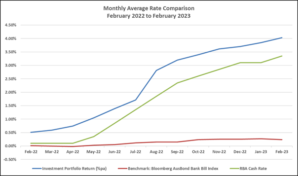
The weighted average interest rate of the portfolio is
4.03% compared to 3.85% for the prior month. For the past 12 months the
weighted average interest rate of the portfolio was 2.51% compared to the average
Ausbond Bank Bill movement of 0.14% and the average Reserve bank of Australia
Cash Rate of 1.83%.
Monthly Investment Income* vs Budget
|
|
February 2023
$
|
Year to Date
$
|
|
Investment Income
|
578,526
|
3,977,170
|
|
Adjustment for Fair Value
|
4,124
|
15,745
|
|
Total Investment Income
|
582,650
|
3,992,915
|
|
|
|
|
|
Budgeted Income
|
50,500
|
409,500
|
*Includes
all cash and investment holdings


Statement of Compliance
|
Portfolio
Performance vs Bank Bill Index over 12-month period.
|
✔
|
Council’s
investment performance did exceed benchmark.
|
|
Monthly
Income vs Budget
|
✔
|
Council’s
income from investments did exceed monthly budget.
|
|
Investment
Policy Compliance
|
|
|
|
Legislative
Requirements
|
✔
|
Fully
compliant
|
|
Portfolio
Credit Rating Limit
|
✔
|
Fully
compliant
|
|
Institutional
Exposure Limits
|
✔
|
Fully
compliant
|
|
Term
to Maturity Limits
|
✔
|
Fully
compliant
|
Restricted
cash, cash equivalents and investments
The breakdown of restrictions is not available for the
current month within the timeframe for the completion of the Monthly Investment
Report. Accordingly, the total cash and investments and restrictions related
thereto are presented for the previous month.
At the end
of January 2023 total cash & investments were $187,257,340 and were made up
of the following reserve allocations.
|
Allocation of Funds
|
Amount ($)
|
Percentage
|
|
Externally Restricted
|
53,030,140
|
28.32%
|
|
Internally Restricted
|
81,001,029
|
43.26%
|
|
Total Restricted
|
134,031,169
|
71.58%
|
|
Unrestricted
|
53,226,171
|
28.42%
|
|
Total
|
$ 187,257,340
|
100.00%
|
ECONOMIC
NOTES
(Source: Primarily extracted from information supplied by
Laminar Capital Pty Ltd)
The global economic growth
outlook has brightened in January and February making reducing inflation a more
challenging task for central banks. In the US the tight labour market and
growth in real household income are priming spending and renewed optimism about
the US economic outlook. The pronounced slowing in annual inflation evident in
late 2022, however, is showing signs of faltering causing reassessment of how
high interest rates may need to be pushed up by the Federal Reserve. The same
trade-off between stronger-than-expected growth and less progress reducing high
inflation placing pressure on central banks to lift interest rates more is also
in play in Europe, parts of Asia and also Australia, notwithstanding recent
Australian data pointing to less tight labour market conditions than expected.
The resilient US economy is
threatening less reduction in inflation than expected previously. In January,
annual CPI inflation decreased only marginally to 6.4% y-o-y from 6.5% in
December and with core inflation (excluding food and energy prices) down to
5.6% y-o-y from 5.7% in December. There were also signs of acceleration in the
prices of services threatening a slower and longer battle ahead getting
inflation down. The Federal Reserve’s preferred inflation measure, the
core personal consumption expenditure deflator, also showed less deceleration
than hoped for in January at 4.3% y-o-y, down from 4.4% in December. All of the
inflation measures are still well above the Fed’s 2% inflation target and
are driving the Fed towards further rate hikes and to possibly a funds rate
peak above current market expectation around 5.3%.
In China, Lunar New Year
celebrations mean that little economic data have been released in February. At
the beginning of the month, January purchasing manager reports show a
noticeable improvement in the wake of China’s various policy about-turns
away from restriction and towards promoting economic growth. The official
January manufacturing PMI lifted to 50.1 from 47.0 in December and the non-manufacturing
(services) PMI jumped to 54.4 from 41.6. The Caixin PMI’s show less
pronounced improvement - the manufacturing PMI lifting to 49.2 from 49.0 in
December and the Non-manufacturing PMI lifting to 52.9 from 48.0. China still
faces significant challenges reviving an over-supplied, over-indebted
residential property market and repairing international trading relationships
harmed during earlier industry sector crackdowns, but unlike other major
economies where monetary policy tightening threaten weaker growth ahead,
China’s growth rate will lift materially this year on policy
reversal.
Perhaps the most pronounced
improvement in the near-term economic growth outlook relative to earlier
expectations has occurred in Europe. Warm winter weather and bigger than
expected energy savings by European businesses blunted feared energy price
hikes removing one big constraint on European growth. The EU economy grew 0.1%
q-o-q in Q4, 1.9% y-o-y in Q4 2022 and now seems likely to register positive
GDP growth again in Q1 2023. The January manufacturing PMI rose to 48.8 from
47.8 in December, while the non-manufacturing (services) sector PMI rose to
50.7 from 49.8 in December. Labour market conditions remain very tight with the
unemployment rate holding down near a quarter-century low at 6.6%. Labour
disputes pushing for higher wages are widespread and annual CPI inflation,
although falling is very high at 8.6% y-o-y in January. The European Central
Bank is promising to get inflation down and again hiked by 50bps at its
early-February policy meeting taking the deposit rate to 2.50%. It is promising
more rate hikes ahead, a reason to believe that the recession threat in Europe
has been delayed, but not removed.
In Australia, economic
growth has been strong and high annual inflation has not peaked yet in the
data. Both strong growth and high inflation predispose the RBA to hiking the
cash rate further and reflected in statements in February that it expects more
rate hikes over coming months. This week, Q4 GDP data will be released and is
expected to show quarter-on-quarter growth of 0.9% compared with 0.6% in Q3
which will leave Q4 annual real GDP around 2.8% y-o-y, strong by international
comparison. There are signs in early Q1 2023 economic readings, however, that
point to some near-term softening in economic growth.
|

|
Report To Ordinary Council MEETING
|
|
ITEM NO. 10.1 - 28 March 2023
|
10.0 Community and Belonging
Division Reports
|
ITEM 10.1
|
Community
Safety Advisory Committee - Confirmed Minutes of 24 November 2022
Meeting
|
|
REPORTING MANAGER
|
Executive
Manager Community, Arts & Culture
|
|
TRIM file
REF
|
2022/823012
|
|
ATTACHMENTS
|
1 ⇨Minutes - Community Safety Advisory Committee -
20221124 - Confirmed (Included In Attachments Booklet)
|
purpose
To report the Minutes of the Community Safety Advisory
Committee meeting held on 24 November 2022.
REPORT
The Community Safety Advisory Committee is a committee of
Council established to provide guidance to Council on community safety issues
impacting the Northern Beaches.
The meeting held on 24 November 2022 included discussion on
the following items:
· Police Report
· Environmental Compliance Report
· E-cigarettes (Vaping)
· Draft Youth Voice Action Plan
· Confirmation of senior sector representative on the Committee
· Northern Beaches Police and Council Operational Meeting
· Sexual Assault Prevention and Response Working Group update
· Committee membership
· MoWaNa Safe Space
The Minutes of the Community Safety Advisory Committee
meeting of 24 November 2022 were confirmed by the Committee at the meeting of
16 February 2023 (Attachment 1).
At Agenda Item 7.0, the Committee proposed that membership
be expanded to include all local State and Federal Members of Parliament. This
resolution of the committee will be the subject of a separate report to
Council.
LINK TO COUNCIL STRATEGY
This report relates to the Community Strategic Plan Outcome
of:
Community and belonging - Goal 8 Our community feels safe
and supported
FINANCIAL CONSIDERATIONS
The Minutes of the Community Safety Advisory Committee pose
no financial impact on Council.
ENVIRONMENTAL CONSIDERATIONS
The Minutes of the Community Safety Advisory Committee do
not present matters that will create adverse environmental impacts.
Social considerations
The Committee provides valuable advice relating to social
and community-based outcomes. It includes involvement and engagement with a
broad range of stakeholders.
governance and risk
considerations
The Committee is conducted according to Council’s
governance framework and adopted Terms of Reference.
RECOMMENDATION OF Director Community and Belonging
That
Council note the Minutes of the Community Safety Advisory
Committee meeting held on 24 November 2022.
|
|
Report To Ordinary Council MEETING
|
|
ITEM NO. 10.2 - 28 March 2023
|
|
ITEM 10.2
|
Funding
Review of the Social Services Sector
|
|
REPORTING MANAGER
|
Manager,
Social Planning & Services
|
|
TRIM file
REF
|
2023/056413
|
|
ATTACHMENTS
|
1 ⇨Attachment 1 - Outcomes Reports - Social Service
Organisations (Included In Attachments Booklet)
|
purpose
To review and determine Council financial assistance to the
social services sector. This includes a review of funding to Community Northern
Beaches, Northern Beaches Women’s Shelter and the Avalon Youth Hub
through the auspice organisation, The Burdekin Association, and proposed
changes to the Community Development Grants Program.
executive summary
As per Section 356 of the Local Government Act 1993,
a Council may, in accordance with a resolution of the council, contribute money
or otherwise grant financial assistance to persons for the purpose of
exercising its functions.
Council has provided financial subsidies to Community
Northern Beaches (formerly known as Manly Community Centre) and Northern
Beaches Women’s Shelter (formerly known as Manly Women’s Shelter)
since amalgamation in 2016, as a continuation of long-standing funding
agreements with the former Manly Council. In 2018, the Burdekin Association was
successful in securing $90,000 in Council funding through an Expression of
Interest process, with the proposal of a Youth Wellbeing Hub to act as a triage
and assessment facility for young people and their families.
In 2020 the agreements for all three organisations were
extended and Council resolved to review the financial assistance prior to the
end of the funding period in June 2022. It also resolved that Avalon Youth Hub
identify other funding sources prior to June 2022 to become self-sufficient
during this period and not reliant on future Council funding.
At the Council meeting on 26 April 2022, it was resolved to
extend the agreements for all three organisations and provide an additional 12
months of financial assistance, funding to cease on 30 June 2023. A total of
$252,500 (ex GST) per annum was allocated to these organisations in the 2022/23
financial year. The resolution 106/22 stated:
That Council:
1. Allocate $97,000 (ex GST) in the 2022/23
financial year as financial assistance to Community Northern Beaches, in
accordance with section 356 of the Local Government Act 1993.
2. Allocate $65,500 (ex GST) in the 2022/23
financial year as financial assistance to Northern Beaches Women’s
Shelter, in accordance with section 356 of the Local Government Act 1993.
3. Allocate $90,000 (ex GST) in the 2022/23
financial year as financial assistance to Avalon Youth Hub through the auspice
organisation The Burdekin Association, in accordance with section 356 of the
Local Government Act 1993.
4. Delegate authority to the Chief Executive Officer to negotiate
service contracts with Community Northern Beaches, Northern Beaches
Women’s Shelter and Avalon Youth Hub through the Burdekin Association,
including reporting on KPIs and service outcomes set by Council, and financial
acquittals.
5. Provide staff support to Community Northern Beaches, Northern
Beaches Women’s Shelter and Avalon Youth Hub, through The Burdekin
Association, to address financial sustainability and reliance on Council
funding in the long term.
6. Review the future allocation of financial and in-kind assistance to
social service organisations and schedule a Councillor workshop on this matter
within the next 6 months.
To progress this resolution, Councillor briefings were held
on 5 September 2022, 29 November 2022 and 14 February 2023 to assist Council in
determining a clear long-term plan to support the local social services sector
in line with the strategic aims of Council. At these briefings, three options
were proposed for Council’s consideration:
· Option 1: Continue current financial assistance to the three
organisations for three years.
· Option 2: Discontinue current financial assistance incrementally
over three years and redirect funds towards a new Community Partnership Grants
program.
· Option 3: Discontinue current financial assistance on 30 June 2023
and redirect funds towards a new Community Partnership Grants program.
This review identified the opportunity to broaden
Council’s support to the social services sector through a new community
partnership grants program to support social services delivering focused
services on strategic priorities. The review assumed that the total amount of
funding currently allocated to direct financial assistance and community grants
programs would not be reduced.
This report will outline the three options for
Council’s consideration.
Financial assistance of $261,085 (ex GST) indexed by CPI at
3.4% from the 2022/23 financial assistance of $252,500 (ex GST) has been
included in Council’s draft 2023/24 Operational Budget.
This funding review also recommended consideration that any
existing Community Development Grants Program provide targeted seed funding
support towards smaller and emerging community groups. As such it is proposed
to introduce a new small grants program to build the capacity of small and
emerging community groups and organisations within the existing operational
budget funding.
RECOMMENDATION OF Director Community and Belonging
That Council:
1. Consider
the options for funding social service organisations and determine the option
for implementation.
2. Delegate
authority to the Chief Executive Officer as required to implement the decision
of Council including any provision of financial assistance under Section 356 of
the Local Government Act, 1993.
3. Note
the proposed change to the annual Community Development Grants Program to
include a Small Grants Program within existing operational budget.
BACKGROUND
Council’s Social Sustainability Policy clearly
articulates the role of local government and Council in the delivery of
community development and services to the community. Key sections of the Policy
Statement include:
Northern Beaches Council acts
principally as a facilitator and enabler of community development and services,
with activities carried out in collaboration with service providers including
community groups, charitable organisations, government and non-government
agencies, and neighbouring Councils.
It further states:
Through these activities
Council will work strategically with local services to maximise the efficiency
and quality of service delivery to the Northern Beaches community.
Council encourages, enables and
assists local groups and organisations to provide relevant services and
activities for residents of the Northern Beaches and will consider providing
services directly when there is an identified priority and where no other
organisation has the capacity or ability to provide the priority service.
The Policy outlines several of the key activities of Council
including:
To maximise the use of
community buildings and the sustainability of the social services sector,
Council facilitates the colocation of services and the provision of community
service hubs (Activity 5. Delivering Infrastructure).
History of current funding model
Former Manly Council had agreed funding arrangements in
place with Manly Community Centre & Services Inc. (now named Community
Northern Beaches) and Manly Women’s Shelter Inc. (now named Northern
Beaches Women’s Shelter). At the Council meeting on 27 June 2017 a
three-year extension of funding was approved for both organisations. An additional
$10,000 was allocated to Manly Community Centre to make up for a shortfall in
funding for their Homeless Outreach Service. Since that time both organisations
have changed their name to reflect their broader service areas across the
Northern Beaches Local Government Area.
An Administrator’s Minute at Council’s meeting
of 27 June 2017 endorsed funding for several new programs that support arts and
culture, youth, environmental sustainability, and community events on the
Northern Beaches. One of these programs related to a Youth Wellbeing Hub with
the following detail:
ii. Youth Wellbeing Hub in the
northern part of the local government area (e.g., Mona Vale): seed funding
(e.g., rental assistance) for establishment of a space for hosting youth outreach
services - $90,000 per year for two years commencing 2017/18 with an intent to
secure long term external funding beyond the seed funding term.
Funding was approved at the Council meeting on 27 February
2018, with the Burdekin Association successful in securing the Council funding
through an Expression of Interest process, with the proposal of a Youth
Wellbeing Hub to act as a ‘triage and assessment facility for young
people and their families’. Due to the Covid19 pandemic this funding was
extended to 31 December 2020.
At the Council meeting on 27 October 2020, it was resolved
to extend the agreements for all three organisations and provide an additional
18 months of financial assistance. This funding was scheduled to cease on 30
June 2022. A total of $252,500 (ex GST) per annum was allocated to these
organisations in the 2021/22 financial year.
Council’s decision of 27 October 2020 required staff
to review the financial assistance prior to the end of the funding period. It
also resolved that Avalon Youth Hub identify other funding sources prior to
June 2022 to become self-sufficient during this period and not reliant on
future Council funding.
At the Council meeting on 26 April 2022, it was resolved to
extend the agreements for all three organisations and provide an additional 12
months of financial assistance with funding to cease on 30 June 2023. A total
of $252,500 (ex GST) per annum was allocated to these organisations in the
2022/23 financial year. This also included a review of the financial assistance
prior to the end of the funding period. Councillor briefings were provided on 5
September 2022, 29 November 2022 and 14 February 2023 to assist in determining
the desired outcomes and criteria for ongoing use of financial assistance.
The total funding provided to local social services by
Council in 2022/23 was $408,058.60, which included the above $252,500 to these
three organisations and $155,558.60 towards the annual Community Development
Grants Program supporting 22 organisations for grants up to $10,000. This
grants program is highly competitive and since commencing in 2018 an average of
78 applications are received each year, with on average 27 organisations (35%)
receiving funding.
Under this grant program, Northern Beaches Women’s
Shelter was successful in receiving $7,500 towards a Safety and Wellbeing
program in 2021/22 and in receiving $10,000 towards the Northern Beaches
Domestic Violence Response Innovation (in partnership with other providers) in
2022/23. The Burdekin Association received $10,000 in 2022/23 towards Wellbeing
Adventure for young people.
Council funded the fit out of the Community Services Hub at
52 Raglan Street Manly and provides rental subsidies to Community Northern
Beaches at this location and Brookvale Community Centre. A rental subsidy is
also provided to Women and Children First (formerly Manly Warringah
Women’s Resource Centre).
Funding Review
In accordance with the Council resolution of 26 April 2022,
a full review of the funding provided by Council to social service
organisations and activities has been undertaken. Attachment 1 provides
Outcomes Reports for each of the funded organisations for
Quarter 1 (Jul-Sep) and Quarter 2 (Oct-Dec) of 2022/23 as per their funding
agreements.
With around two thirds of Council’s total financial
assistance towards local social services going towards three services,
consideration of redirecting these funds through a community partnership
program could increase equity and transparency and provide an opportunity to
ensure financial assistance remains in line with the long-term strategic aims
of Council and demand for service and support in the community.
This review also recognised the need to provide smaller seed
funding grants to support and build the capacity of smaller and emerging
community groups with an annual turnover under $500,000 per annum, as per the
small charities’ classification provided by the Australian Charities and
Not-for-profits Commission.
FUNDING OPTIONS
Three options have been developed and are presented for
consideration:
Option 1: Continue current financial assistance to the
three organisations for three years.
This option will continue the current commitment of Council
into the future, recommending that three-year funding agreements be entered
into with Community Northern Beaches, Northern Beaches Women’s Shelter
and the Avalon Youth Hub through the auspice organisation, The Burdekin Association.
The recommendation for the funding contracts to run for
three years is to provide greater service continuity as opposed to shorter term
contracts.
|
Pros
|
Cons
|
|
· Contributes to the service delivery capacity of these
organisations providing support for young people, children and families,
women experiencing domestic violence and people experiencing homelessness.
|
· Does not provide opportunities for other not for profit and
community organisations to provide targeted community services through
financial assistance from Council.
|
|
· Provides continuity of financial assistance to existing
organisations and time for them to identify alternative funding sources.
|
· Promotes reliance on ongoing Council funding for sustainability.
|
|
· Does not provide long term strategic direction and process towards
Council’s support of social services organisations.
|
Option 2: Decrease financial assistance incrementally
over three years and redirect funds towards a new
Community Partnership Grants program.
If this option was supported by Council, it is proposed to
enter into funding agreements for 3 years to 30 June 2026, at the existing
funding level (plus CPI) for the first 12 months in 2023/24, at 75% for the
second 12 months in 2024/25 and 50% for the 2025/26 financial year.
From 2025/26 onwards, it is proposed that a Community
Partnership Program commence in a staged approach corresponding to the above
staged reduction in financial assistance, with a funding pool of $65,000 in
2025/26 and $200,000 in 2026/27.
This grant program will be for eligible organisations to
apply for grants of up to $50,000 for up to three years according to strategic
outcome areas identified by Council. The current funded organisations will also
be eligible to apply for this funding at the completion of their three-year
funding agreement.
The proposed Community Partnership Program provides targeted
and effective services in line with identified long term outcomes and embeds
equity and sustainability into the funding and application process.
|
Pros
|
Cons
|
|
· Contributes to the service delivery capacity of the existing
organisations, allowing time to develop a new framework and process for
continuity of service and to maximise community outcomes.
|
· Community outcomes may be reduced via an extended change process
of financial assistance
|
|
· Provides opportunity for Council to set financial assistance
according to desired strategic outcomes and for other not for profit and
community organisations including the existing organisations to receive
larger financial assistance from Council from 2026/27.
|
· Change is incremental over time and may result in some confusion
by existing organisations.
|
|
· Provides time for the currently funded services to identify
alternative funding sources.
|
· Existing services must identify other funding sources to address
discontinuation of financial assistance after three years.
|
Option 3: Discontinue financial assistance
on 30 June 2023 and redirect funds towards a new Community Partnership Grants
program.
In this option Council will cease directly funding Community
Northern Beaches, Northern Beaches Women’s Shelter and Avalon Youth Hub
via The Burdekin Association and redirect all the funds for social service
organisations and activities into a new Community Partnership Program. This
grant program will be for eligible organisations to apply for grants of up to
$50,000 for up to three years according to strategic outcome areas identified
by Council. The current funded organisations will also be eligible to
apply for this funding along with all other not for profit organisations. The
existing community grants program and a new small grants program would provide
varied levels of support to the sector in addition to this new program.
Option 3 can facilitate broader long term community
investment with three tiers of funding to the social sector. Outcomes and
criteria would need to be developed for the new grants programs that will
provide a clearer long-term plan of support that aligns with the strategic aims
adopted by Council.
It will provide opportunities for a wider range of service
providers and not for profit organisations to establish new programs and
activities in line with community priorities.
This option may impact negatively on Community Northern
Beaches, Northern Beaches Women’s Shelter, the Avalon Youth Hub and their
ability to continue to provide the current services to the community if they
are unable to source alternative funding. The service outputs delivered by each
organisation between July and December 2022 are outlined in the Outcomes
Reports provided in Attachment 1. This provides an indication of the potential
loss of service for part of the community if the three organisations are not
able to continue providing the programs listed without this funding. It is
expected that re-direction of funds to other service providers would result in
a corresponding increase in community outcomes through all tiers of the
proposed grants programs provided funding is maintained at current levels.
|
Pros
|
Cons
|
|
· Increased community outcomes aligned with long term identified
strategic priorities resulting from open and equitable application process
from a greater variety of local organisations.
|
· Current funded organisations may have reduced service delivery
capacity.
|
|
· Provides opportunity for Council to set financial assistance
according to desired strategic outcomes and for other not for profit and
community organisations including the existing organisations to receive
larger financial assistance from Council from 2026/27.
|
· Provides limited time for existing organisations to identify
alternative funding sources and may impact their service delivery capacity in
the short term.
|
|
· Provides for an increase in funds and outcomes towards community
grants programs
|
· Existing grant recipients may have reduced service outcomes if
maximum grant amounts are reduced (eg – establishing a $5000 cap on a
small grant program)
|
COMMUNITY DEVELOPMENT GRANTS PROGRAM
This funding review also recommended consideration for the
existing Community Development Grants Program to provide targeted seed funding
support towards smaller and emerging community groups. As such, it is
recommended to continue with existing stream of grants of up to $10,000 towards
larger projects and to introduce a Small Grants Program for grants up to
smaller $5,000 towards eligible organisations with an annual turnover under
$500,000 per annum, as per the small charities’ classification provided
by the Australian Charities and Not-for-profits Commission.
Funding towards this new Small Grants Program could be taken
from the current $120,000 Community Development Grants Program resulting in a
reduced funding pool to $90,000. The proposed grant program would be open all
year round and have a streamlined approval process by a Councillor assessment
panel. It is noted that Options 2 and 3 could provide an increase funding to
these grant streams if supported.
CONSULTATION
Council staff continue to liaise regularly with management
at Community Northern Beaches, Northern Beaches Women’s Shelter and
Avalon Youth Hub via The Burdekin Association, including quarterly reporting
requirements. Council staff provided Councillor briefings on 5 September 2022,
29 November 2022 and 14 February 2023 on this matter.
TIMING
If the option endorsed requires Funding Agreements these
will commence on 1 July 2023. The new Small Grants Program if endorsed
would commence in the 2023/24 financial year, with advertising to commence in
July 2023. The annual Community Development Grants Program will commence
advertising in June and recipients determined by Council in October 2023.
LINK TO STRATEGY
This report relates to the Community Strategic Plan Outcome
of:
· Community and belonging - Goal 8 Our community feels safe and
supported
· Partnership and participation - Goal 22 Our Council builds and
maintains strong partnerships and advocates effectively on behalf of the
community
This report relates to the Council’s Social
Sustainability Policy articulating the role of local government and Council in
the delivery of community development and services to the community:
Northern Beaches Council acts principally as a
facilitator and enabler of community development and services, with activities
carried out in collaboration with service providers including community groups,
charitable organisations, government and non-government agencies, and
neighbouring Councils.
This report relates directly to the Better Together 2040
Social Sustainability Strategy outcome for a resilient and adaptive social
service sector on the Northern Beaches to provide support and resources in
response to changing community needs.
financial considerations
Financial assistance of $261,085 (ex GST indexed by CPI at
3.4%) has been included in Council’s draft 2023/24 Operational Budget. If
Options 1 or 2 are endorsed, Funding Agreements will be entered into which
outline the terms and conditions of the approved applicant, including annual
reporting and financial acquittal of the funds.
$120,000 for the Community Development Grants Program is
included in the draft 2023/24 Operational Budget. The proposed Small Grants
Program for 2023/24 can be met within the existing annual Community Development
Grants Program budget. All options outlined in this report can be funded by the
amounts included in the draft 2023/24 Operational Budget and the Long-Term
Financial Plan.
social considerations
There are positive social impacts for the local community
resulting from financial assistance and community grants programs. Allocation
of financial assistance through a longer-term strategic framework and process
would likely increase community outcomes by social service providers and more
broadly community satisfaction.
Option 1 allows for continued support provided to the
current three organisations to deliver positive community outcomes, however,
does not enable other unfunded services to access similar support.
Options 2 and 3 provide a broader strategic framework for
apportioning financial assistance in a fair and equitable manner, enabling
access to funding for other eligible and relevant social services and ensuring
alignment to defined strategic priorities. These options elevate
Council’s commitment to social services with a defined community
investment program with three tiers of grant funding. Option 2 provides time
for these three organisations to adapt to this new framework whilst remaining
eligible for funding.
environmental considerations
There are no environmental considerations.
governance and risk
considerations
Council may grant financial assistance for the purpose of
exercising its functions under Section 356 of the Local Government Act 1993,
by Council resolution.
Council’s role is to ensure any funds allocated to
external parties will be spent consistent with the objectives and directions of
its’ endorsed strategies and plans that have been developed in
consultation with the community.
The risk to Council regarding community concern differs with
each option presented. There may be some community concerns relating to the
reduced or ceasing of funding to these existing services. Risks relating to
this have been mitigated in Option 1 and Option 2 through a staged and scaled
reduction of financial assistance.
Previous Council resolutions have also noted the intention
to assist organisations benefitting from funding to work towards financial
sustainability and a lesser reliance on Council funding.
|

|
Report To Ordinary Council MEETING
|
|
ITEM NO. 12.1 - 28 March 2023
|
12.0 Planning and Place Division
Reports
|
ITEM 12.1
|
Planning
Proposal 10-12 Boondah Road, Warriewood PEX2022/0001
|
|
REPORTING
MANAGER
|
Executive
Manager Strategic & Place Planning
|
|
TRIM
file REF
|
2023/141328
|
|
ATTACHMENTS
|
1 ⇨Minutes of Northern Beaches Local Planning Panel
Meeting 21 December 2022 (Included In Attachments Booklet)
2 ⇨NSW State Emergency Service (SES) - Letter of
Advice (Included In Attachments Booklet)
3 ⇨Submissions - Summary of Issues Raised (Included In
Attachments Booklet)
|
NOTE: This item was listed on the agenda but not dealt with at the 28
February 2023 Council Meeting
PURPOSE
To seek Council’s approval to reject
a Planning Proposal for land at 10-12 Boondah Road, Warriewood, and not
forward the Planning Proposal to the Minister for Planning.
executive summary
Henroth Pty Ltd submitted a
Planning Proposal to amend Pittwater Local Environmental
Plan 2014 by rezoning land at 10-12
Boondah Road, Warriewood from RU2 Rural Landscape to R3 Medium
Density Residential and C2 Environmental Conservation, along with other
amendments, to enable residential
development comprising 40 dwellings in a 3-storey
townhouse typology and 4 affordable housing dwellings for a 10-year period in a manor home or 2-storey residential flat building
typology.
The Planning Proposal has been assessed and
found to be inconsistent with the strategic planning framework and fails to
demonstrate sufficient strategic and site-specific merit, particularly in
relation to flooding, water management, biodiversity impacts, affordable
housing, and overall public benefit.
On 21 December
2022, the Northern Beaches Local Planning Panel (the Panel) considered the
Planning Proposal and recommended that Council reject the Planning Proposal and
not forward it on for a Gateway Determination. The Panel’s full
recommendation is contained in Attachment 1.
RECOMMENDATION OF
ACTING Director
Planning and Place
That:
1. Council reject the proponent’s Planning Proposal and not
forward it to the Minister for Planning for a Gateway determination for the
following reasons:
A. The Planning Proposal has not demonstrated sufficient strategic
merit or site-specific merit, and is inconsistent with the following elements
of the strategic planning framework:
i. Greater Sydney Region Plan:
Objective 27:
Biodiversity is protected, urban bushland and remnant vegetation is enhanced.
Objective
36: People and places adapt to climate change and future
shocks and stresses.
Objective 37: Exposure to natural and urban
hazards is reduced.
ii. North District Plan:
Planning Priority N16: Protecting and enhancing bushland
and biodiversity
Planning Priority N22: Adapting to the impacts of urban and
natural hazards and climate change
iii. Towards 2040 Local Strategic Planning Statement for the Northern
Beaches:
Priority 1:
Healthy and valued coast and waterways
Priority 2:
Protected and enhanced bushland and biodiversity
Priority 8:
Adapted to the impacts of natural and urban hazards and climate change
Priority 15: Housing supply, choice, and affordability in
the right locations
iv. Warriewood Valley Strategic Review Addendum Report adopted 17
November 2014 and amended 19 December 2017 by Northern Beaches Council and
incorporated in Clause 6.1 Warriewood Valley Release Area of the Pittwater
Local Environmental Plan 2014.
v. Local Planning Directions issued by the Minister for Planning:
Local Planning
Direction 4.1: Flood Prone Land
Local Planning
Direction 4.2 Coastal Management
Local Planning Direction 4.4:
Planning for Bushfire Protection.
B. The NSW State Emergency
Service (SES) has raised significant concerns in relation to flood risk, and
has indicated it does not support rezonings to enable development on the floodplain
with risk management strategies that rely on early evacuation, private alarm
systems, shelter in place, and transfer of residual risk in terms of emergency
response to the SES, thereby increasing demands on SES resourcing and
capabilities and potentially increasing risk to life, health and property for
both existing and future communities.
C. The
Planning Proposal seeks to rezone land within the flood planning area and
insufficient information has been provided to demonstrate that the proposed development
will not:
i. result in a net loss of flood storage in the floodplain;
ii. result in significant adverse impacts to other properties;
iii. result in an increased requirement for government spending on
emergency management services, flood mitigation and emergency response
measures;
iv. adversely affect the safe occupation and efficient evacuation of
people; and
v. place people and property at unacceptable
risk in the event of a major flood.
D. The Planning Proposal is
inconsistent with the objectives of Clause 5.21 Flood Planning of Pittwater
Local Environmental Plan 2014.
E. The
Planning Proposal is likely to result in unacceptable impacts on biodiversity,
particularly in respect of:
i. failure to site and design development to avoid and minimise impacts
to biodiversity;
ii. impacts on the remnant Bangalay Sand Forest, an Endangered
Ecological Community of significant biodiversity value, as well as impacts to
threatened species habitats, reduction in local wildlife connectivity, and
potential for altered flow regimes to impact groundwater dependent ecosystems;
iii. uncertainty with regards to Biodiversity Certification and, given
that offset obligations are not available in the Northern Beaches, the
likelihood of a net loss of local biodiversity;
iv. failure to exclude from development all the mapped Coastal Wetland;
v. failure to provide an adequate 15-metre-wide landscaped buffer,
exclusive of the bushfire asset protection zone, to protect the adjacent
wetlands; and
vi. inadequate groundwater investigation and water quality monitoring to
demonstrate adequate management of impacts on the downstream environment and
the wetland.
F. The Planning Proposal does
not comply with Council’s Affordable Housing Policy as it only offers
dwellings as affordable housing for a period of 10 years, and it fails to
include a suitable mechanism to include the site in the Northern Beaches
Affordable Housing Contributions Scheme.
G. The
proposed C2 zoning of land could trigger acquisition obligations for Council,
noting that this matter may be able to be clarified if the Planning Proposal
were to progress.
BACKGROUND
Previous
Planning Proposals
The site has been the subject of three
previous Planning Proposals which have not proceeded, in summary:
2013 Planning Proposal (PP0007/13)
The 2013 Planning Proposal lodged with the
former Pittwater Council, which included the subject site and land at 6
Jacksons Road and 3, 6 and 8 Boondah Road, was for a large mixed use
development comprising retail, commercial and residential land uses. The former
Pittwater Council resolved to not support this proposal on 17 March 2014. Upon
a review sought by the applicant, the Joint Regional Planning Panel’s
decision on 17 February 2015 was to recommend against the Planning Proposal
proceeding to Gateway Determination.
2016 Planning Proposal (PP0005/16)
The 2016 Planning Proposal, which included
the subject site and land at 6 Jacksons Road, sought to enable development of a
4-storey residential flat building with a yield of up to 30 dwelling units, and
a 2-storey bulky goods retail centre of up to 17,000sqm GFA. Northern Beaches
Council resolved not to support this proposal on 28 March 2017. Upon review
sought by the applicant, the Sydney North Planning Panel’s unanimous
decision on 31 May 2017 was that the Planning Proposal should not be submitted
for Gateway Determination as it had not demonstrated strategic merit.
Subsequent legal challenges by the applicant to the Land & Environment
Court and the Court of Appeal were dismissed.
2019 Planning Proposal (PEX2019/0003)
The 2019 Planning Proposal, which included
the subject site and land at 6 Jacksons Road, sought to enable development of
five 4-storey residential flat buildings with a yield of up to 130 dwelling
units, along with an offer to enter into a Planning Agreement to dedicate land
at 6 Jacksons Road to Council and facilitate the provision of new and expanded
sports fields. Council resolved not to support this proposal on 17 December
2019. Upon review sought by the applicant, the Sydney North Planning
Panel’s unanimous decision on 8 September 2020 was that the Planning
Proposal should not be submitted for Gateway Determination as it had not
demonstrated strategic merit.
Pre-Lodgment
Meeting
A pre-lodgment meeting was held with
Council officers on 22 July 2021 in relation to the current Planning Proposal,
and formal notes were issued to the applicant on 27 August 2021. Amongst other
things, the notes include specific requirements and considerations in relation
to the strategic planning context, flooding, biodiversity, bush fire, riparian
values, stormwater quality management, traffic and road design, parks and
landscaping, dwelling density, affordable housing, development contributions,
and the necessary components of justification for a Planning Proposal.
Revisions to Warriewood Valley
Development Contributions Plan
At the time of the pre-lodgement meeting, the Warriewood Valley
Development Contributions Plan Amendment 16, Revision 3 June 2018 (2018
Contributions Plan) was under review by the Council. Section 6.2.3 of
2018 Contributions Plan identified the strategy for provision of open space and
recreation areas to meet the needs of the anticipated residential population in
the release area. Land at 10-12 Boondah Road, Warriewood (the site of the
current Planning Proposal), was identified as two of five properties in the
Southern Buffer area for purchase for future active open space.
To date, the
Council has only been successful in purchasing one of the five properties (3
Boondah Road, Warriewood) identified for future active open space.
The applicant
was advised at the pre-lodgement meeting that provision of open space,
particularly active open space such as sports fields, remains a key area in
which community needs are not adequately met in Warriewood Valley, and that the
Council was considering alternatives.
At its meeting
on 28 June 2022, the Council resolved to adopt the Warriewood Valley
Development Contributions Plan Amendment 16, Revision 4 2022 (2022
Contributions Plan) which came into effect on 1 July 2022. The 2022
Contributions Plan included revised calculations of open space still to be
delivered, based on updated assumptions on anticipated development in the
release area. Active open space still to be delivered has been revised down
from 3.74ha in the 2018 Contributions Plan to 1.31ha in the 2022 Contributions
Plan. Section 6.2.3 no longer identifies properties in the Southern Buffer
area, including the site, for purchase for future active open space. The 2022
Contributions Plan recognises that opportunities for future land purchase for
active open space are limited and focuses instead on satisfying remaining
active open space demands through the embellishment of existing sports fields
to increase available hours of use through upgrading turf surfaces, improving
drainage and providing lighting.
Site
Description
 The site is located at 10-12 Boondah
Road, in Warriewood Valley (see Figure 1).
The site is located at 10-12 Boondah
Road, in Warriewood Valley (see Figure 1).
The site adjoins Warriewood Wetlands to
the west, land developed with a 3-storey residential flat building to the north
(part of the larger residential complex developed by Meriton at the corner of
Boondah Road and Macpherson Street), and a rural property to the
south-east with a dwelling.
Warriewood Square
shopping centre is further south of the site on Jacksons Road, and to the east
on the opposite side of Boondah Road is bushland and a Sydney Water sewerage
treatment plant.
The area referred
to in planning documents as the Southern Buffer, derived its name from a 400m
buffer distance to the sewerage treatment plant which was originally embargoed
from the land release area until Sydney Water developed a plan for capping the
plant to reduce odour impacts on the surrounding area.
Other land uses
along Boondah Road include public sports fields and netball courts, a Council
depot, and a community centre.
The site has a
total area of 2.044ha, comprising lots described in the table below.
|
Address
|
Property Description
|
Area
|
Owner
|
|
10 Boondah Road
|
Lot 4 DP 26902
|
1.027
|
Henry Fraser
Pty Ltd
|
|
12 Boondah Road
|
Lot 3 DP 26902
|
1.017
|
Cassius
Investments Pty Ltd
|
The site is used in part for rural and
storage purposes, and contains sheds, a small paddock and at least one
dwelling. The topography of the site is generally flat and low-lying land,
draining to the Warriewood Wetlands adjoining to the west and Narrabeen Creek
to the south.
Although parts of the site are cleared,
substantial vegetation exists on the site having significant biodiversity and
wildlife connectivity value, including Threatened Ecological Communities (TEC)
and Threatened Species and their habitats. In particular, the site contains two
Endangered Ecological Communities (EEC), being Bangalay Sand Forest an EEC
under the NSW Biodiversity Conservation Act 2016 (NSWBC Act) located on 12
Boondah Road, and Swamp Oak Floodplain Forest an EEC within NSWBC Act and
Commonwealth Environmental Protection and Biodiversity Conservation Act 1999
(EPBC Act) located on 10 Boondah Road. Vegetation on the site merges with that
of the adjacent Warriewood Wetlands and includes intact mature canopy.
The site is in the Flood Planning Area. Council’s Flood Hazard
Map identifies High, Medium and Low Risk Precinct areas within the site (see
Figure 2).
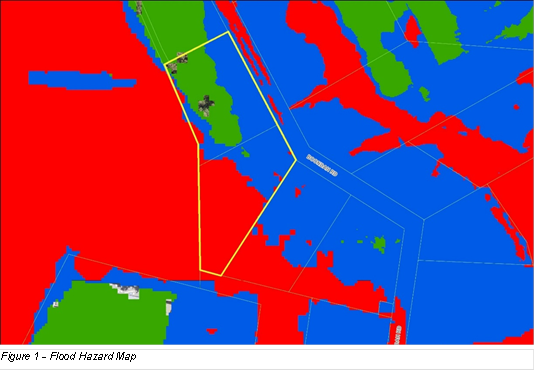

The site includes Vegetation Category 1 and
Vegetation Buffer on Council’s Bushfire Prone Land Map (see Figure 3).
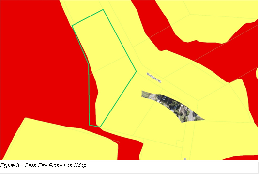

The Proposal
Henroth Pty Ltd lodged a Planning Proposal
application via the NSW Government Planning Portal and it was assigned for review by Council on 22 July 2022. Various technical
supporting documents were submitted with the application. On several occasions
after lodgement, further information was submitted by the proponent, including
amendments to the proposal. All additional information and amendments have been
considered in the assessment contained in this report. The Planning Proposal
and all associated documentation has been made accessible to the Council for
its consideration.
The Planning Proposal seeks to amend
Pittwater Local Environmental Plan 2014 (LEP) for land at 10-12 Boondah Road,
Warriewood to permit future residential development of 44 dwellings, including
40 x three-storey multi-dwelling housing dwellings (townhouses) and four
dwellings in a manor house form to be used as affordable housing for a period
of 10 years.
A conceptual Site Plan shows six rows of
townhouses with internal circulation roads and driveways across much of the
site, along with a kids’ playground, pedestrian pathway/fire trail,
informal open space areas and a riparian corridor in the southern part of the
site (see Figure 4). This Site Plan is a revision of an earlier version lodged
with the application, in response to some issues raised at a meeting with
Council officers. The revision increases, to 15m, the setback of the internal
road from the site’s boundary to Warriewood Wetland, with the end
townhouses in each row re-oriented to achieve suitable road/driveway gradients.
The development footprint remains largely unchanged.
The Site Plan indicates a 6m setback of the
proposed townhouses from Boondah Road, and a 24m wide bushfire asset protection
zone (APZ) between the proposed townhouses and the boundary to the Warriewood
Wetland, with roads, paths and parking located within the 24m wide APZ area.
The APZ is also intended to overlap a 15m wide ecological buffer to the
adjacent Wetland.
Other changes
to the Planning Proposal as lodged, include:
· a statement that the proposed C2 zone boundary would be adjusted to
include all the mapped Coastal Wetland under State Environmental Planning
Policy (Resilience & Hazards)
· an alternative building height limit using maximum RL to AHD (flood
planning level plus 9.5m).

The three-storey townhouse designs
incorporate garage, living, dining and kitchen at ground level, and bedrooms
and bathrooms on the two levels above (see Figures 5 and 6).
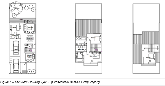
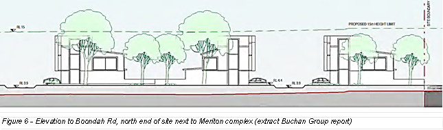
Most, if not all the proposed R3 Medium Density Residential zoned
land (around 90% of total site area) will be subject to earthworks, mostly
filling to raise the land to achieve levels required to meet flood planning
criteria, including townhouse ground levels at RL4.4m, road and driveways at RL3.9m, and
park and play areas at RL2.5m. Boondah Road along the site’s
frontage is also to be raised to RL3.9m - which is 1% AEP (previously referred
to as 1 in 100-year flood level) plus an allowance for climate change. The
earthworks are likely to necessitate removal of most if not all the existing
vegetation in the proposed R3 zoned area. No earthworks are proposed for
the riparian corridor proposed to be zoned C2 Environmental Conservation.
The applicant
has not made an offer to enter into a Planning Agreement. The applicant has stated the intention is for the C2 zoned land to
remain in private ownership as part of a Community Title.
Assessment of Planning Proposal
The following
assessment is set out in accordance with the relevant NSW
Government Local Environmental Plan Making Guideline (Guideline).
Part 1
– Objectives or Intended Outcomes
The stated objectives and
intended outcomes of the Planning Proposal are to:
· continue residential development adjoining existing residential
development within the Warriewood Valley release area
· provide residential accommodation opportunities responding to
identified demand
· optimise the utilisation of existing infrastructure
· preclude from urban development those areas identified through the
studies undertaken that are not suited for urban development
· to accommodate approximately 44 dwellings
equating to a yield of approximately 22 dwellings per hectare.
The stated objectives rely on
the proponent’s stated premise that the Planning Proposal responds to the
outcomes of the previous Rezoning Review for the 2019 Planning Proposal. The
proponent suggests that the SNPP found that the proposed development
potentially had site specific merit but not strategic merit, and that changes
to the 2018 Warriewood Valley Development Contributions Plan (Contributions
Plan) whereby Council is no longer targeting the land for acquisition for open
space resolve a key reason for the 2019 Planning Proposal failing to satisfy
strategic merit.
Response
This premise is not
accepted. Although the quantum of open space still to be delivered in the
Release Area has been revised down and the site is no longer identified in the
Contributions Plan for purchase for future active open space,
this does not mean that the site by default becomes suitable in a strategic
planning sense for urban or residential development.
The site’s earlier
designation for active open space was not based solely on meeting the needs of
the anticipated population, but also on the findings of a suite of technical
studies that informed the planning strategy for Warriewood Valley Release Area.
These studies included land capability mapping based on identified
environmental constraints to development such as flooding, bush fire and
biodiversity. Strategic Merit is discussed further in Part 3 below.
The current zoning remains
strategically appropriate particularly having regard for the constraints of the
site and the commentary from the SES.
Part 2
– Explanation of Provisions
The
applicant’s proposed LEP amendments seek to:
· rezone the site from RU2 Rural Landscape to R3 Medium Density
Residential and C2 Environmental Conservation (see Figures 7 and 8)
· increase the maximum building height from 8.5m to 15m over the
proposed R3 zoned land, or an alternative approach that imposes an RL to AHD
limit based on flood planning level plus 9.5m
· remove the minimum subdivision lot size
· amend the Urban Release Area Map and clause 6.1(3) to apply a dwelling
yield range of 40-45 dwellings.
Response – Proposed Zoning
The proposed R3
zoning may be a suitable zoning to accommodate residential development at the
density that is proposed. However, the extent of development proposed is
not appropriate having regard to flooding, biodiversity, and water quality.
These issues are discussed further in Part 3. As discussed above, the
current zoning remains strategically appropriate particularly having regard for
the constraints of the site and the commentary from the SES.
The proposed C2 Environmental zoning is not acceptable, for the
following reasons:
· It has not been demonstrated that the extent of the proposed C2
zoning adequately aligns with the biodiversity values of the land and the
conservation requirements to protect these values.
· While the applicant has stated that the proposed C2 zoning boundary
will encompass all the mapped Coastal Wetland under State Environmental
Planning Policy (Resilience and Hazards) 2021, the Site Plan has not been
revised to reflect this. Although conceptual in nature, the Site Plan and plans
included in a supporting memo by Calibre dated 14 October 2022 show roads,
earthworks, asset protection zones, and indicative locations of bioretention
basins, stormwater filters and discharge points within areas of mapped Coastal
Wetland.
· While the applicant has stated that the
proposed C2 zoned land is intended to remain in private ownership under a
Community Title scheme, without confirmation to indicate otherwise, it is
possible that the C2 zoning could trigger an obligation for Council to acquire
the land under the owner-initiated hardship provisions of the Land Acquisition
(Just Terms Compensation) Act 1991, if the C2 zoning is deemed to be reserving
the land for use for a public purpose. Despite enquiries made by Council
planners, the Department of Planning and Environment (DPE) was unable to
clarify the operation of the relevant legislation in this instance due to legal
complexity. While this remains uncertain, it represents a financial risk for
Council.
· While the proposed C2 zoning may offer better protection of
biodiversity values than the current RU2 Rural Landscape zoning, there is
uncertainty over responsibility
for implementing the proposed conservation measures, and the prospects
of Biodiversity Certification.
If the Planning Proposal were to proceed,
the above issues could be investigated further, and potentially resolved
through suitable detailed information and amendments to the proposal.
Amongst other things, to allay concerns about an acquisition obligation,
Council would need confirmation from the DPE that it
would not require the proposed C2 zoned land to be included on the Land
Reservation Acquisition Map in Pittwater LEP and assurance
from a legal perspective that the proposed C2 zoned land would not be subject
to owner-initiated acquisition provisions of the Land Acquisition (Just Terms
Compensation) Act 1991.
If the Planning Proposal were to proceed,
the precise boundaries of the new zones would need to be determined through
resolution of the relationship of the proposed C2 zone boundary to mapped
Coastal Wetland under SEPP (R&H) and ground-truthing of vegetation and
biodiversity mapping.
Response – Building Height
In response to
concerns about the proposed 15m building height limit, the applicant suggested
an alternative building height limit using a maximum RL
based on flood planning level plus 9.5m.
No ground survey
information has been submitted to indicate the maximum level of fill necessary
to achieve flood planning levels. The onus is on the applicant to satisfy
Council that future buildings would not be excessive in scale or out of
character with the area. Nevertheless, while precise
LEP provisions or maps have not been provided, the applicant has indicated the
intended outcome is for future buildings be limited to two-storeys plus attic
with a maximum height above filled ground levels of 9.5m. This is sufficient
explanation to assist in legal drafting of a suitable LEP amendment if the
Planning Proposal were to proceed. As such, building height is no longer
considered to be a reason to reject the proposal and has been deleted from the
recommendation since reporting to the Local Planning Panel.
Response – Dwelling
Yield Range
Part 6.1 of the
LEP implements the adopted planning strategy for Warriewood Valley Release Area
contained in the Warriewood Valley Strategic Review (WVSR) adopted by former
Pittwater Council and endorsed by NSW Director of Planning in 2013 and the
Warriewood Valley Strategic Review Addendum (WVSR Addendum) adopted in 2014 and
amended in 2017 (WVSR Addendum).
Clause 6.1(3)
of the LEP specifies dwelling yield ranges to control the density of
residential development. The dwelling yield ranges are based on densities
adopted through the WVSR and WVSR Addendum for individual residential sectors,
with density calculated on the ‘developable area’ – that is,
the total site area excluding land identified as environmentally sensitive,
creek line corridor and/or having no potential for development due to a
prevailing condition/hazard.
32 dwellings
per developable hectare is the maximum density that has been planned and
applied generally across most of the undeveloped release land in Warriewood
Valley through the WVSR and WVSR Addendum.
The Planning Proposal seeks a dwelling
yield range of 40-45 dwellings which equates to a density of approximately 22
dwellings/ha. However, this calculation is not appropriate as not all of the
site can reasonably be considered ‘developable’ given significant
environmental constraints associated with flooding and riparian and
biodiversity values, especially in the southern half of the site.
The Water Management Report by Calibre
nominates at page 37 that the ‘developable land’ is a minimum of
1.32ha, defined as the land within the low and medium flood hazard zones.
1.32ha at a density of 32 dwellings per hectare will permit 42 dwellings.
On this basis, the proposed dwelling yield
range is generally consistent with the density limit of 32 dwellings/ha applied
by the planning strategy for Warriewood Valley.
Affordable
Housing
Council’s stated policy is that it is
committed to a 10% affordable rental housing target for all planning proposals
for urban renewal or greenfield development, and the Contributions Scheme and
related LEP provisions are the mechanism by which affordable housing is to be
secured.
The proposed LEP amendments do not include
any amendments to give effect to an affordable housing contribution in
accordance with Council’s Affordable Housing Policy and its Affordable
Housing Contributions Scheme. Such amendments would include a new LEP clause
and map, and a new section in the Contributions Scheme applying to the subject
land, to specify the proportion of total residential gross floor area to be
dedicated as affordable housing or provided as a monetary contribution in lieu
of dedication as a condition of a future development consent.
The Planning Proposal includes an offer to provide four dwellings as
affordable housing for a period of 10 years, managed during that time by a
registered community housing provider. Affordable housing for a time
limited period is not acceptable, nor is it in accordance with Council’s
Policy. Dwellings secured for affordable housing are required to be in
Council ownership in perpetuity.
Part 3 –
Justification
Strategic Merit
Section A – Need for the Planning
Proposal
Q1. Is the planning
proposal a result of an endorsed LSPS, strategic study or report?
The applicant’s report states the
site has been part of the Warriewood Valley Release Area since its inception
and is identified in the WVSR and WVSR Addendum as land having development
capability ranging from Least to More.
The case for need put forward by the
applicant is based on housing need, in particular that the proposal responds to
a shortfall of 275 dwellings identified in Council’s Local Housing
Strategy (LHS), a shortfall of 251 dwellings from the original forecasts for
the Release Area, and the exacerbation of any shortfall resulting from the
abandonment of the Ingleside Place Strategy.
The proposal also relies on the provision
of four dwellings for a period of 10 years as affordable housing which is
stated to maximum opportunities for affordable housing dwellings.
Response
The applicant’s justification with
regards to need is not supported.
The LHS forecasts housing demand to the
year 2036 and identifies a deficit in capacity under the current planning
controls of 275 dwellings across the entire Northern Beaches local government
area. The LHS estimates of capacity to meet housing demand factored in 1000 new
dwellings in Ingleside. In response to the State Government’s
decision last year to not proceed with Ingleside Place Strategy,
Council’s strategic planning team is actively investigating alternative
locations.
The LHS builds on the strategy for housing
identified in Council’s Towards 2040 Local Strategic Planning Statement
(LSPS) of focusing new housing in and around centres with good transport.
Centre Investigation Areas are the cornerstone of Council’s adopted
approach to meeting housing targets and the LHS identifies Brookvale, Dee Why,
Mona Vale, Manly Vale and Narrabeen as priorities for urban renewal in the
short-medium term. Medium density residential development is to be
concentrated in strategic and selected town centres on the current and future
B-line routes, and these centres will be the subject of detailed planning to
identify opportunities for renewal and respond to the unique circumstances and
character of each centre. As discussed further under Q.4 below, Warriewood was
not identified as a viable option for a Centre Investigation Area in the LHS.
Planning for Brookvale to deliver on
housing targets is well advanced. Brookvale strategic centre has potential to
meet the 275 dwellings deficit identified in the LHS and a major portion of the
1000 dwellings no longer being planned in Ingleside, in a location having
significant advantages in terms of existing infrastructure, proximity to
employment and services, and an efficient, transit-supportive urban structure
that can promote less reliance on private vehicles and less impact on traffic
congestion. Forward planning for growth and development in Brookvale
began in 2016 and a revised Draft Structure Plan was endorsed by Council in
November 2022 and is undergoing a final phase of public exhibition until 28
February 2023. The plan envisages an additional 1300 apartment-style dwellings
in and around Brookvale centre, which will add to housing diversity.
Given the progress made to date and the
ability for Council to meet its housing targets through a methodical,
strategic, principles-based approach to increasing housing capacity in and
around its most accessible centres, there is no need for the subject Planning
Proposal to rezone land in Warriewood, especially given the site-specific
constraints and potential environmental, social, and economic impacts which are
discussed in the section on Site-Specific Merit later in this report.
Q2. Is the planning
proposal the best means of achieving the objectives or intended outcomes, or is
there a better way?
The applicant’s report suggests the
site is a logical extension of existing urban zoned lands and the Planning
Proposal is a logical infill development opportunity that does not face the
infrastructure delivery constraints that pose challenges to the Ingleside and
Frenchs Forest release areas.
Response
As discussed
under Q1. above, Council is on track to meet the housing targets identified in
its’ LHS and detailed planning is underway for Centre Investigation Areas,
including Brookvale. Phase 1 of the Frenchs Forest Precinct is being
implemented through new planning controls that came into effect on 1 June 2022
and is scaled to ensure growth and development is in line with infrastructure.
The subject
site faces other challenges that Frenchs Forest and Brookvale are not so
affected by, for example flooding, bushfire and biodiversity. There are better
ways to achieve the objectives or intended outcomes, as discussed further
below.
Section B
– Relationship to strategic planning framework
Q3. Will the planning proposal give effect to the
objectives and actions of the applicable regional, or district plan or
strategy?
The applicant’s report states
that the Planning Proposal is consistent with Greater Sydney Region Plan and
North District Plan.
Response
The proposed development involves
significant issues associated with flood risk and the SES has raised
significant concerns. Shelter in place is not an acceptable strategy to manage
flood risk for future development of housing on land not currently zoned for
housing. The proposed development will result in unacceptable impacts on
biodiversity, fails to provide an adequate buffer to adjacent wetland, and
insufficient information has been submitted in relation to water quality
management and impacts on groundwater dependent ecosystems. For these reasons,
the Planning Proposal is inconsistent with:
Greater Sydney Region Plan
· Objective 27: Biodiversity is protected, urban bushland and remnant
vegetation is enhanced
· Objective 36: People and places adapt to climate change and future
shocks and stresses
· Objective 37: Exposure to natural and urban hazards is reduced.
North District Plan:
· Planning Priority N16: Protecting and enhancing bushland and
biodiversity
· Planning Priority N22: Adapting to the impacts of urban and natural
hazards and climate change
Q4. Is the planning proposal consistent with a council
LSPS that has been endorsed by the Planning Secretary or GSC, or another
endorsed local strategy or strategic plan?
The applicant’s report states that the Planning
Proposal is consistent with the endorsed LSPS and the endorsed LHS.
Response -
Towards 2040 Local Strategic Planning Statement
The proposed
development involves significant issues associated with flood risk and the SES
has raised significant concerns. Shelter in place is not an acceptable strategy
to manage flood risk for future development of housing on land not currently
zoned for housing. The proposed development will result in unacceptable impacts
on biodiversity, fails to provide an adequate buffer to adjacent wetland, and
insufficient information has been submitted in relation to water quality
management and impacts on groundwater dependent ecosystems.
With good progress made to date and the
ability for Council to meet its housing targets through a methodical,
principles-based approach to increasing housing capacity and diversity in and
around its most accessible centres, there is no need to rezone the subject site
to allow housing, especially given the flooding constraints and potential
environmental impacts.
The proposal fails to incorporate
appropriate provision for contributing affordable housing dwellings in
perpetuity in accordance with the relevant policy and scheme.
The proposed C2 zoned land presents
uncertainty for Council with regards to potential acquisition triggers and
responsibility for ongoing implementation of conservation measures.
For these reasons, the Planning Proposal is
inconsistent with the following Priorities of the LSPS:
· Priority 1: Healthy and valued coast and waterways
· Priority 2: Protected and enhanced bushland and biodiversity
· Priority 8: Adapted to the impacts of natural and urban hazards and
climate change
· Priority 15: Housing supply, choice and affordability in the right
locations
· Priority 16: Access to quality social and affordable housing
It is furthermore inconsistent with the
following Housing Principle adopted in the LSPS:
· Limit development where there are unacceptable risks from natural
and urban hazards, or impact on tree canopy.
Response –
Northern Beaches Local Housing Strategy
Council’s
ongoing forward planning for centres will address the shortfall of 275
dwellings identified in the LHS and find alternatives for the 1000 dwellings
previously envisaged for Ingleside.
The Centre Investigation Areas earmarked in
the LHS for investigation for renewal will be the key locations
for delivering new housing with detailed planning for these centres looking to
provide a variety of housing types including medium to
higher density housing in highly accessible locations.
The second approach outlined in the LHS,
Low-rise Housing Diversity Areas, identifies Warriewood as one of several local
centres potentially suited to low to medium density typologies within 400m of
centres. This approach is explicitly subject to environmental and other
constraints, which means the site’s flooding, bushfire and biodiversity
constraints would need to be properly considered and addressed.
Warriewood’s disjointed layout, with
the shopping centre being more than 350m from the B-line stop, does not lend
itself to a decision on balance where the benefits of providing more housing
would outweigh the disbenefits associated with flood risk and impacts on
biodiversity.
These issues with the location of the
B-line stop, the layout of the wider centre, and the local environmental and
flooding constraints, are the reason Warriewood did not present as a viable
option for a Centre Investigation Area in the LHS.
As the Planning Proposal does not
adequately address the site’s environmental constraints, it is
inconsistent with the LHS.
Warriewood Valley Strategic Review and Warriewood
Valley Strategic Review Addendum
Assessment of Strategic Merit
should also consider the adopted planning strategy for
Warriewood Valley Release Area contained in the Warriewood Valley Strategic
Review Report adopted by the former Pittwater Council and endorsed by the NSW
Director of Planning in 2013 (WVSR) and the Warriewood Valley Strategic Review
Addendum Report adopted in 2014 and amended in 2017 (WVSR Addendum).
Clause 6.1(3) of the LEP, which implements the planning strategy for Warriewood
Valley Release Area, includes the objectives:
(a) to permit
development in the Warriewood Valley Release Area in accordance with
the Warriewood Valley Strategic Review Report and the Warriewood
Valley Strategic Review Addendum Report, and
(b) to
ensure that development in that area does not adversely impact on waterways and
creek line corridors, protects existing native riparian vegetation and
rehabilitates the creek line corridors.
The catalyst for WVSR was an approval in 2011 by the
Planning Assessment Commission (PAC), under its now repealed Part 3A powers, of
the Meriton development at the corner of Macpherson Street and Boondah Road,
comprising multiple 3-4 storey residential flat buildings with a total of
approximately 450 dwellings. Part of this development adjoins the subject
site’s northern boundary. The PAC called for a comprehensive strategic
study for all undeveloped land in Warriewood Valley, including for the first
time the Southern Buffer area, which includes the subject site.
The WVSR investigated the
remaining undeveloped lands, first utilising composite land capability mapping
of a range of environmental, economic, and social characteristics to classify
land into categories of capability for development ranging from Least to Most
developable. It then drew on a major hydrology study to inform developable land
classifications, and used independent urban design, strategic transport, and
economic feasibility studies to determine the recommended density and dwelling
yield ranges for specific residential sectors. These were incorporated into the
controls in clause 6.1 of the LEP, and such provisions required endorsement by
the State Government.
The WVSR explored development
opportunities for the Southern Buffer, including the potential for a mixed-use centre.
It recognised that under existing conditions, flood depths exceed 1m
across most of the Southern Buffer in a 1% AEP event and that a significant
amount of compensatory cut and fill would be required to create two developable
areas; one being 0.87ha at the northern end of the Southern Buffer (i.e., part
of 10 Boondah Road), the other at the corner of Pittwater and Jacksons Rds. It
also recognised the high biodiversity values of some of the Southern Buffer
land. Although a draft concept plan and design principles were publicly
exhibited, due to community opposition and a reluctance amongst landowners to
collaborate, the concept did not progress any further. No future land use or
dwelling yield was recommended for the Southern Buffer.
The WVSR Addendum was prepared to identify
a forward path for remaining sectors which were not considered or not
identified with a forward path by the WVSR. The WVSR Addendum utilised updated
information on bushfire, flooding, biodiversity, and slope to produce new land
capability mapping. It re-evaluated sector boundaries and recommended
dwelling densities with dwelling yield ranges that were once again incorporated
into subsequent amendments to LEP clause 6.1.
The WVSR Addendum was also informed by the
Pittwater Open Space and Recreation Strategy in 2014, which highlighted a
significant undersupply of active recreation areas in the Pittwater LGA and the
importance of Release Areas providing places and facilities for recreation to meet the needs of their incoming populations. The estimated
remaining open space to be provided in Warriewood Valley Release Area was
identified as 6.32ha, comprising 1.69ha of linear open space and 4.63ha of
active open space.
For the Southern Buffer, based on updated
flood and bushfire information, biodiversity values, and the findings of the
Open Space and Recreation Strategy, no residential potential was
identified. Most of the Southern Buffer, including the subject site was
given a land use designation of ‘Active Recreation’. This
outcome is reflected in the absence of any Southern Buffer land from the table
in Clause 6.1(3) of the LEP which specifies the number of dwellings to be
erected on specified land areas in the Release Area. It was also later
reflected in the Warriewood Valley Development Contributions Plan which
specifically identified 5 properties along Boondah Road, including the subject
site, for purchase for active open space.
Following years of unsuccessful attempts to
purchase this land, revisions to the Contributions Plan which came into effect
on 1 July 2022 reflect a change in strategy to focus on embellishment of
existing sports fields instead of purchasing of additional land to meet the
needs of the population for active open space. While the subject site
is no longer identified for purchase for active open space,
this does not mean that site by default becomes suitable in a strategic
planning sense for residential development. The planning strategy for
Warriewood Valley set out in the WVSR and the WVSR Addendum was informed by
land capability mapping and a suite of technical studies that recognised
constraints to development such as flooding, bush fire and biodiversity. The
site has never been allocated an endorsed forward path for residential
development because of these characteristics. Any Planning Proposal to enable
residential development would need to demonstrate that these characteristics
can be properly managed through a design and impact assessment process that
achieves a site that is suitable for the intended uses, without significant
adverse economic, social, or environmental impact. This has not been
demonstrated in this case.
Q5. Is the planning proposal consistent with any other
applicable State and regional studies or strategies?
See earlier comments under Question 3.
Q6. Is the planning proposal consistent with applicable
SEPPs?
The
applicant’s report states that the Planning Proposal does not conflict
with any of the SEPPs.
Response - SEPP
(Resilience and Hazards)
In relation to Chapter 2 Coastal Management
of the SEPP (R&H), the site is mapped as Coastal Wetlands and Proximity
Area for Coastal Wetlands (see Figure 9).
In accordance
with Part 2.2 of the SEPP (R&H), Council must not grant consent for
development unless it is satisfied that:
· for Coastal Wetlands, “sufficient measures have
been, or will be, taken to protect, and where possible enhance, the
biophysical, hydrological and ecological integrity of the coastal wetland or
littoral rainforest”; and
· for
Proximity Areas, “the proposed development will not significantly
impact on -
(a) the
biophysical, hydrological or ecological integrity of the adjacent coastal
wetland or littoral rainforest, or
(b) the quantity
and quality of surface and ground water flows to and from the adjacent coastal
wetland…”
The Planning
Proposal has not demonstrated that a future development application will be
able to satisfy Council in accordance with these requirements.
Part of the mapped Coastal Wetland falls
within the proposed R3 zoned area that is intended to be developed, including
areas subject to proposed earthworks, roads, parking, bioretention basins,
stormwater filters and outlets, and management as a bushfire APZ. Wetland
vegetation will necessarily be removed and altered stormwater flow regimes
could have detrimental impacts on groundwater dependent ecosystems both within
the site and the adjacent Warriewood Wetlands.
All of the site that is mapped Proximity
Area will be subject to major earthworks to raise the land above flood planning
levels which will significantly alter flows to and from the site. The applicant
has not submitted information regarding the potential impact of the altered
flow regimes on the Wetland or undertaken adequate groundwater investigation
and water quality monitoring.
The Planning Proposal fails to provide a
15m wide extensively landscaped buffer to protect the adjacent wetlands in
accordance with clause 6.6 of the Pittwater DCP (DCP) due to management
requirements of the overlapping bushfire Asset Protection Zone (APZ). In order
to function as an effective ecological buffer to the wetland, the DCP requires
a 15m buffer consisting of landscaped mounds with mass planting of native trees
and shrubs. The buffer should be exclusive of any APZ, and not overlap with it
as is proposed. This is consistent with conditions of approval set by the PAC
for the adjacent Meriton development, requiring a 25m wide APZ outside of a 10m
wide Vegetated Wetland Buffer Zone and no excavation works in the Wetland
Buffer Zone.
The Planning Proposal does not take
adequate measures to protect or enhance the hydrological and ecological
integrity of the mapped Coastal Wetland or to minimise impact on the
quantity and quality of surface and ground water flows to and from the adjacent
Coastal Wetland.
Furthermore, any development within the
mapped Coastal Wetland area would be Designated Development requiring an
Environmental Impact Statement under the SEPP (R&H) provisions.
Having regard for deficiencies associated
with the proponent’s Strategic Bushfire Study, as discussed further under
Q.7 below, concern exists in relation to the ability for a future development
application to satisfy section 4.14 of the Environmental Planning and
Assessment Act 1979.
Q7. Is the planning
proposal consistent with applicable Ministerial Directions (s.9.1 directions)?
The applicant’s report states the Planning Proposal would be consistent with all
relevant Directions.
Response - Local
Planning Direction 4.1 Flooding
The Planning Proposal is not consistent
with clause 4.1(2) of Direction 4.1 as it seeks to rezone land within the flood
planning area from a Rural zone to a Residential zone.
The Planning
Proposal is not consistent with clause 4.1(3) of Direction 4.1 as it will:
· permit development that will result in significant flood impacts to
other properties,
· permit a significant increase in the development and/or dwelling
density of that land; and
· is likely to result in a significantly increased requirement
for government spending on emergency management services, flood mitigation and
emergency response measures.
Direction 4.1 requires planning proposals
to give effect to and be consistent with the principles of the Floodplain
Development Manual 2005 (the Manual), any flood study prepared by Council in
accordance with the Manual, and the Considering Flooding in Land Use Planning
Guidelines which introduced Standard Instrument LEP clauses related to
Flooding.
The Manual promotes a merit approach to
development decisions in the floodplain, taking into account social, economic,
and ecological factors as well as flooding considerations. Its primary
objective is to reduce the impact of private and public losses resulting from
floods, and it looks to containing the potential for flood losses through
application of planning and development controls and enabling councils to be
responsible for determining the appropriate planning and development controls
to manage future flood risk.
The Pittwater Development Control Plan
(DCP) includes flood-related controls in section B3.11 Flood Prone Land.
For land affected by flooding in High and Medium Risk Flood Precincts, the
controls require that development must demonstrate, amongst other things, for
all flood events up to the 1% AEP event: no adverse impacts on flood levels or
velocities caused by alterations to the flood conveyance, no adverse impacts on
surrounding properties, and no net loss of flood storage.
The Planning Proposal involves filling of
most of the proposed R3 zoned land and the amount of fill is substantial to
achieve flood planning levels for the townhouses of RL4.4m, well above existing
ground levels of around 2-4m AHD. Without compensatory cut, this will result in
a sizeable net loss of flood storage from the site which will need to be
absorbed by other properties in the floodplain. The proponent has not
demonstrated no net loss of flood storage. No volumetric calculations
indicating the balance of cut and fill have been provided. The proponent has
instead focused on modelling to demonstrate no adverse impacts on surrounding
properties and compliance with specific DCP controls for Warriewood Valley
Release Area under C6.1.
Development that results in a net loss of
flood storage is contrary to specific controls established by Council to manage
flood risk.
Cumulative
loss of floodplain storage is an important consideration, particularly where land is not
currently zoned for the type and intensity of development proposed. Any net
loss of flood storage from the site, as a result of filling to achieve adequate
levels for new houses and roads, requires other properties to absorb the
storage lost. Flood levels and flows can increase on other properties and the
combined, cumulative effects may be excessive if other sites in the catchment
are similarly rezoned and filled for housing following any precedent set by
this Planning Proposal.
Risks to life and property are critical
considerations under Direction 4.1.
The results of Calibre’s flood
modelling of the Probable Maximum Flood (PMF) event indicate that at 195
minutes into a PMF storm event, internal driveways and Boondah Road become
unsafe for small vehicles, and at 210 minutes into a PMF storm event water
levels on the site have risen to 4.54m and will enter the ground floors of the
townhouses, and anyone who has not evacuated will need to shelter in place on
the first floor above. The applicant proposes a private evacuation alarm system
(light and siren) set to trigger at a flood level 90 minutes into the PMF storm
event allowing 75 minutes for people to pack and leave, and another sensor set
to trigger at 180 minutes (different light and siren) indicating it is too late
to leave and residents must shelter in place.
Evacuation will add pressure on a road
system that is restricted in major flood events, and the efficacy of a private
alarm system is questionable in terms of who maintains it in working order and
how future residents will understand and respond to alarms when activated.
The NSW State Emergency Service (SES) provided advice (Attachment 2)
on the Planning Proposal. The SES advice refers to the Ministerial Direction
for Flooding and the NSW Floodplain Development Manual and identifies the following
issues with Planning Proposal:
· zoning should not enable development that will result in an increase
in risk to life, health or property of people living on the floodplain
· warning technology cannot be relied on to guarantee a faster
response from the community and any advantage gained by the application of
warning technology should be considered as a safety factor, not a potential for
increasing development
· evacuation must not require people to drive or walk through flood
water
· development strategies relying on deliberate isolation or sheltering
in buildings surrounded by flood water are not equivalent, in risk management
terms, to evacuation
· shelter in place is not a flood management strategy endorsed by the
SES for future development, such an approach is only suitable to allow existing
dwellings that are currently at risk to reduce their risk, without increasing
the number of people subject to such risk
· SES is opposed to imposition of development consent conditions
requiring private flood evacuation plans rather than application of sound land
use planning and risk management
· SES is opposed to development strategies that transfer residual
risk, in terms of emergency response activities, to the SES and/or increase
capability requirements of the SES
· consent authorities should consider the cumulative impacts any
development will have on risk to life and the existing and future community and
emergency service resources.
The views of the SES, as the lead
agency in NSW for planning for, responding to, and coordinating recovery from
floods, should be paramount in land use decisions for flood-prone land. The
agency has expressed a view that it does not support future development (i.e.
new residential development enabled by rezoning) on flood prone land where
early evacuation, private alarm systems and shelter in place strategies are
necessary to manage flood risk. In other words, the Council should not support
rezonings which place new communities in locations that expose people and property
to risks associated with major floods and increase the potential burden on
emergency services.
The proponent submitted a memorandum by
Calibre dated 16 September 2022 in response to issues raised by the SES in its
preliminary advice. Upon review of this further information, the SES advised it
does not have any further comment.
The proponent further submitted a letter by
SJB Planning dated 20 December 2022 and a letter by Calibre dated 20 December
2022, in which points were raised about the consistency of the flood risk
assessment and evacuation requirements of the proposal with DPE’s Flood
Risk Management Manual and associated Flood Risk Management Guide EM01 (Guide
EM01) published in February 2022, in particular the flow charts for rezoning
and greenfield developments.
The SES confirmed that Guide EM01 is a
draft, and the proposal has not satisfied the conditions outlined in Guide
EM01, in particular:
· Noting that Boondah Road will be raised to the level of 1% AEP plus
climate change, this area will still be a Low Flood Island. Low Flood Islands
represent the highest risk to life.
· The proposed development does not have sufficient time to
evacuate.
· The proposed modifications do not address the evacuation
constraints.
· The flood evacuation constraints in an area should not be used as a
reason to justify new development by requiring the new development to have a
suitable refuge above the PMF. Allowing such development will increase
the number of people exposed to the effects of flooding.
Since the release in draft of the
abovementioned Guide EM01, catastrophic floods have occurred in NSW, and it is
understood that the Department of Planning and Environment is giving further
thought to the ways in which natural hazards can be better managed early in the
strategic planning process.
The NSW government has explicitly
recognised the important role of the planning system in supporting resilience
in places and communities, and its’ commitment to continuous improvement
to the planning system to create greater resilience to chronic stresses and
episodic shocks such as floods and bushfires.
Effective planning can and should reduce
exposure to natural hazards. The Planning Proposal is fundamentally contrary to
planning for resilience, as it will increase the number of people exposed to
flood risk on the Northern Beaches.
Council’s Floodplain Planning unit
does not support the Planning Proposal and has indicated the proposal is not
compliant with Local Planning Direction 4.1, identifying the following issues:
· the applicant has not demonstrated that the proposed development
will not result in significant adverse impacts to other properties.
· land filling to raise the roads and building platforms appears to
result in a net loss of flood storage in the mainstream flood lagoon
floodplain.
· no volumetric figures showing the cut and fill balance have been
provided.
· Council must be satisfied that the proposed development will convey
water and have the same flood storage function as existing.
· it is not appropriate for Council to support future development (via
rezoning) that uses shelter in place as a management strategy that will
increase the flood risk and the number of people exposed to flooding.
· the applicant has not demonstrated that the proposed development
will not result in a significantly increase requirement for government spending
on emergency management services, flood mitigation or emergency response
measures.
Council’s
Floodplain Planning unit also identified inconsistencies with:
· principles of the NSW Floodplain Development Manual 2005
· the Australian Disaster Resilience Handbook Collection
· Pittwater LEP Clause 5.21 Flood Planning
Given the level
of filling proposed, loss of flood storage, exposure of people and property to
flood risk, and the reliance on a shelter in place strategy with a private
alarm system, the Planning Proposal is inconsistent with Pittwater Local
Environmental Plan (LEP) clause 5.21 in that it will:
· result in significant adverse impacts to other properties or adverse
cumulative impacts on flood behaviour in a way that results in detrimental
increases in the potential flood affectation of other properties;
· adversely affect the safe occupation and efficient evacuation of
people; and
· place people and property at risk or in intolerable conditions in
the event of a major flood.
With regards to assessing flood risk
for this proposal, Council’s floodplain engineers have advised:
· when assessing flood risk,
Council considers the full range of flood events up to the PMF
· during a PMF event, the
roads will be cut off and evacuation will not be possible
· for events larger than 1%
AEP + CC and up to the PMF event the proposal relies on shelter in place as the
strategy to manage flood risk
· the DCP does allow for
shelter in place when flood free evacuation during a PMF event is not possible,
however as this is a rezoning application and not a development application,
Council needs to consider SES’s concerns and other relevant policies and
guidelines. Shelter in place is generally only suitable for existing dwellings
that are currently at risk to reduce their risk.
The imperative
for Council to carefully consider the risks associated with development on
flood prone land has increased markedly in recent years on account of extreme
weather and flood events on the Northern Beaches and elsewhere in NSW and
Queensland. On 28 June 2022, Council adopted the Northern Beaches Resilience
Strategy, with a key priority and associated action being:
Priority
1. Avoid intensification of development, inappropriate development
and incompatible land uses in areas exposed to natural and urban hazards.
Action 1a. Establish planning controls
that limit intensification, inappropriate development and incompatible land
uses to reduce or avoid risks from natural hazards.
This is a
logical shift in policy toward a more considered and cautious approach to
managing the risk posed by natural hazards, particularly in the context of
climate change.
Response -
Local Planning Direction 4.3 Planning for Bushfire Protection (Direction 4.3)
The referral
response from Council’s Bush Fire Management Coordinator highlights the
following deficiencies in the Strategic Bush Fire Study submitted with the
Planning Proposal:
· “There
is minimal consideration of the likelihood of a bush fire impacting the site
and its potential severity on a landscape scale.
· The
study relies on site specific protection measures rather than assessing the
appropriateness of the proposal in the context of the surrounding landscape.
· The
suitability of the proposal on the landscape should have stronger logical
connections to informing the siting and layout of the proposed development.
· There
is no assessment on the capacity of the road network either internally or
externally to sufficiently handle evacuating residents and responding emergency
services to/from the proposal; nor identification of evacuation routes or
assessment of the potential for the development to become isolated during a
fire event.
· There
is no assessment of the development impact on the provision or capacity of
emergency services, other than minor references to the proximity of surrounding
fire stations.
· There
is no assessment of the provision of infrastructure services to the proposal as
the study suggests that this should be the subject of a separate study.
· There
is limited assessment of the impact of the proposal on neighbouring lands, and
no consideration for managed lands to the south of the proposal to remain such
in perpetuity.
· Site
specific APZs are not contained within the development relying on adjoining
road verges. Should any land with the proposal be vested to Council, Council
may be burdened with the ongoing APZ management of these and/or adjoining road
verges.
· The
study indicates that perimeter roads within the proposal rely on a performance
solution. Performance solutions should be accompanied with the appropriate Bush
Fire Design Brief and/or Bush Fire Management Plan which has not been supplied.”
If the Planning Proposal proceeds through
Gateway Determination, it will be formally referred to the Rural Fire Service
for comment.
Site-Specific Merit
Section C – Environmental, social,
and economic impact
Q8. Is there any likelihood that critical habitat or
threatened species, populations or ecological communities, or their habitats,
will be adversely affected because of the proposal?
The
Applicant’s report states that the Biodiversity Certification process
will manage the potential impacts on identified threatened species, habitat,
ecological communities, and that the masterplan for the proposal has been
guided by the site’s ecological constraints and bush fire management
requirements with the perimeter road network providing a managed edge to the ecological
values of the adjacent Wetland and a defendable perimeter for the development.
Response
The site contains significant biodiversity
values including Threatened Ecological Communities, mapped Coastal Wetland and
Proximity Area for Coastal Wetland, records of threatened species, threatened
species habitats and fauna connectivity.
Areas along the site’s western
boundary and the south-western corner of the site are mapped on the Department
of Planning and Environment’s Biodiversity Values map which identifies land
with high biodiversity value that is particularly sensitive to impacts from
development and clearing. The mapping is part of the Biodiversity Offsets
Scheme (BOS) thresholds and any vegetation clearing as part of future
development will trigger entry into the BOS. The applicant has made application
for BioCertification to the State Government and the Biodiversity Certification
Assessment Report and accompanying Conservation and Vegetation Management Plans
have been formally submitted to Council for comment.
The two
identified Endangered Ecological Communities (EEC) on the site are:
· Bangalay Sand Forest
· Swamp Oak Floodplain Forest
The six
identified threatened fauna species are:
· Grey-headed
Flying-fox (Pteropus poliocephalus)
· Large
Bent-winged Bat (Miniopterus orianae oceanensis)
· Eastern
Cave Bat (Vespadelus troughtoni)
· Southern
Myotis (Myotis macropus)
· Little
Bent-winged Bat (Miniopterus australis)
· Powerful
Owl (Ninox strenua).
Earthworks and clearing for the proposed
development will directly impact all the Bangalay Sand Forest which covers
around 0.23ha and is entirely within the proposed R3 zone residential
area. The complete removal of this vegetation represents the loss of
approximately 50% of the mapped extent of this EEC on the Northern Beaches.
Nine hollow-bearing trees, some with hollows suitable for the recorded Southern
Myotis will be removed. Whilst this vegetation is degraded, intact mature
canopy remains. The layout of the proposed development fails to avoid or
minimise impacts to this EEC. The BioCertification application recommends retirement
of biodiversity credits or more likely payment into the State
Government’s Biodiversity Conservation Fund to offset the impact.
The Swamp Oak Floodplain Forest (SOFF) covers 0.44ha of the
site and 0.18ha would be directly impacted by the proposed development.
The remainder is located within the portion of the site proposed to be zoned C2
Environmental Conservation.
The six recorded threatened fauna species and their habitats
will be significantly impacted and clearing will remove existing wildlife
corridors through the site between core habitats in Warriewood Wetlands to the
west and corridors along Narrabeen Creek to the east of the site.
In addition to the direct removal of vegetation, altered
surface and groundwater flow regimes have potential to adversely impact ground
water dependent ecosystems on the site and in the wetland.
Other potential impacts relate to ‘edge effects’
to the wetland and remaining SOFF associated with maintaining a 24m wide
Bushfire APZ along the site’s western boundary. The required 15m wide
extensively landscaped buffer to the wetland should be outside of the APZ.
The referral
response from Council’s Biodiversity and Planning unit states:
“…the
Planning Proposal is not supported for the following reasons:
· Lack of measures to avoid and minimise impacts to threatened
biodiversity, including the complete removal of Bangalay Sand Forest. It is
noted that the BCAR states that the proposal will lead to the avoidance of the
majority of mapped biodiversity values within the subject lots, however this is
not correct as the full extent of BSF on site will be directly impacted, as
well as impacts to six threatened fauna species and other native flora and
fauna species.
· Regardless of the reduced development footprint, it appears that the
development within the proposed R3 zone intersects the BV map / Coastal Wetland
and as such, the current concept proposal for 10 & 12 Boondah Road would
require an EIS.
· The current design is not sited and designed to avoid and minimise
impacts to biodiversity. The proposal would result in a direct net loss of
biodiversity. Potential impacts that would result from the proposal include
locating dwellings, associated infrastructure, excavation and filling, and APZs
within the mapped coastal wetland. Further impacts to biodiversity include the
clearing of native vegetation and endangered ecological communities, impacts to
threatened species habitats, reduction in local wildlife connectivity, indirect
impacts associated within increased light and noise pollution, and impacts to
ground water dependent ecosystems within the site and adjoining Warriewood
wetlands.
· The requirement for the retention and enhancement of an ecological
buffer to protect the mapped coastal wetland on site and to the adjoining
Warriewood Wetlands needs amendment to achieve a suitable biodiversity outcome
and reduce potential impacts to the adjoining wetland;
· The lack of a 15 metre wide extensively landscaped buffer strip
adjoining Warriewood Wetlands, exclusive of bushfire asset protection zone, and
consisting of landscaped mounds with mass plantings of native trees and shrubs,
locally indigenous canopy trees with native shrubs, locally indigenous canopy
trees with native shrubs and groundcovers as required by the P21 DCP control
6.6 Landscape treatment of the Buffer Strip. …
· Flooding, flood storage and water flows are of concern, and the
areas of significant vegetation (trees), fauna habitats and wetland buffers
should be retained must not be subject to any excavation / filling.
· The removal of wildlife corridors through and surrounding the site
including direct connection to core habitats within Warriewood Wetlands, as
well as connections to the east that form part of a wildlife corridor that
extends further north along the Narrabeen Creek catchment. It is recommended
that a corridor is provided in the northern boundary of the site, thereby
retaining, enhancing and protecting areas of the TEC BSF.
· Potential for indirect and prescribed impacts to TECs, threatened
species and their habitats
· Likelihood of altered surface and groundwater flow regimes, and
therefore potential direct and indirect impacts to Groundwater Dependent
Ecosystems (GDE) on the subject site and in the locality.
· A reliance within the BCAR that an appropriate storm water
management plan will be prepared to avoid impacts on the TEC, and is not
expected to impact on groundwater resources or groundwater dependent
ecosystems.
Therefore,
the range of issues described above, as well as the loss of native tree canopy,
will result in a future development that does not satisfy the applicable
planning controls, and is not supported by Council’s Biodiversity
Planning section.
In addition,
the offset obligations calculated as part of the Biodiversity Certification
Assessment Report for the TECs and threatened species are not available on the
Northern Beaches, and therefore will result in net loss of biodiversity within
the Northern Beaches LGA.”
Council’s Catchments unit also raised
concerns in relation to impacts on groundwater dependent ecosystems, earthworks
in the buffer to the wetland, and the need for water quality monitoring and
further groundwater and hydrological investigations to demonstrate that impacts on the downstream
environment and the wetland can be suitably managed. The Catchments unit does
not support the Planning Proposal as it is not in accordance with Local Planning Direction 4.2 Coastal Management or SEPP
(Resilience and Hazards) 2021.
Q9. Are
there any other likely environmental effects as a result of the planning
proposal and how are they proposed to be managed?
The proponent’s report identifies potential impacts associated
with flood and bushfire hazard, acid sulphate soils and contamination, and
makes reference to various aspects of the design and layout of the proposed
development and studies undertaken for the Planning Proposal as evidence that
these potential impacts can be minimised and are within acceptable levels.
Response
As discussed earlier, in relation to flood
hazard, the SES has raised significant concerns and does not support shelter in
place or private alarm systems as a strategy to manage flood risk for future
development on land not currently zoned for housing. Extensive
filling of the site to achieve flood planning levels will result in net loss of
flood storage in the floodplain and insufficient information has been provided
to demonstrate that the proposed development will not result in adverse impacts
to other properties, place people and property at risk or in intolerable
conditions in the event of a major flood, adversely affect the safe occupation
and efficient evacuation of people, or significantly increase the requirement
for government spending on emergency management, flood mitigation and emergency
response measures.
As discussed earlier, in relation to
bushfire hazard, Council’s Bush Fire Management Coordinator has
identified deficiencies in the Strategic Bush Fire Study submitted by the
proponent.
The applicant’s submissions in
relation to acid sulphate soils and contamination are accepted.
Q10. Has the
planning proposal adequately addressed any social and economic effects?
The
applicant’s report describes the proposed affordable housing, traffic
impact assessment and access road network, and provision of open space with a
playground and pedestrian link between Boondah Road and Warriewood Wetlands in
relation to addressing social and economic effects.
Response
As discussed earlier, the Planning
Proposal fails to include a suitable mechanism to
give effect to an affordable housing contribution in
accordance with Council’s Policy and Contributions Scheme. These
documents contemplate that dwellings secured for affordable housing are meant
to come into Council ownership in perpetuity. Any residential uplift will
require 10% of the dwellings to be affordable housing stock transferred into
Council ownership. Amendments to Council’s Affordable Housing
Scheme and to Pittwater LEP to secure this contribution would need to be made
in conjunction with a Planning Proposal being progressed to Gateway
Determination, and eventually published as part of the rezoning.
Council’s Transport Network Manager
has provided a referral response on the Planning Proposal which indicates that
the road design is acceptable subject to certain requirements which can be
resolved at the more detailed application stage. Although the impact on
the local road network is acceptable, the applicant is still required to
provide confirmation that the modelling requirements of the RMS (now Transport
for NSW) have been met, particularly with regards to potential impacts on the
intersections of Mona Vale Road/ Pittwater Road and Pittwater Road/Warriewood
Road. If the Planning Proposal proceeds through Gateway Determination, it will
be formally referred to Transport for NSW for comment.
The proposed open space area including the
playground will provide for the recreation needs of the new resident
population. The playground and open space would form part of a community title
and be constructed and maintained by the landholders. The playground and open
space are not suitable for Council ownership as a park asset.
The proposed pedestrian pathway connection
between Boondah Road and Warriewood Wetlands would be required to be
constructed by the developer and dedicated to Council to ensure public access.
The location of the pathway through the southern end of the site is potentially
acceptable, however it should be separate to the internal road network and not
cross any internal roads.
There are potential economic effects
associated with the proposed C2 zoned land. While the
applicant has stated that the proposed C2 zoned land is intended to remain in
private ownership, without confirmation to indicate otherwise, there is a
possibility that the C2 zoning could trigger acquisition
and there is no funding mechanism for Council to purchase the land.
There is also no certainty as to who will
be responsible for any ongoing supervision and/or maintenance of this
land, or bushfire APZs and the buffer to the wetland, and it may be a further
economic burden placed upon the Council.
Additionally, as discussed earlier in relation to flood
hazard, the proposed flood responses are insufficient and transfer residual
risk in terms of emergency response to the SES, thereby increasing demands on
SES resourcing and capabilities and potentially increasing risk to life, health
and property for both existing and future communities.
Section D – Infrastructure (Local,
State and Commonwealth)
Q11. Is there adequate public
infrastructure for the planning proposal?
The referral
response from Council’s Infrastructure unit identifies the following
local infrastructure requirements if a rezoning to permit an additional 45
dwellings on the site were to proceed:
· Reconstruction of Boondah Road
The applicant’s report acknowledges
the requirement for raising of Boondah Road to the level of 1% AED plus climate
change. If the Planning Proposal is to proceed, the full width of Boondah
Road for the entire length of the site’s frontage would need to be
constructed up to the level required for flood evacuation (1% AED plus climate
change) including suitable transitions to the existing carriageway alignments.
· Payment of development contributions towards open space
infrastructure and community facilities in accordance with the applicable
Development Contributions Plan.
An additional 45 dwellings will represent
around 120 additional residents, or an increase of around 2.2% in the total
population forecast for Warriewood Valley. Council’s Parks unit has
advised that this will place additional pressure on active recreation facilities,
but in and of itself does not justify further augmentation of existing
facilities in Warriewood Valley or the acquisition of additional ones.
The approved design of a new community
facility in Warriewood Valley will once constructed provide sufficient floorspace
to accommodate the additional resident population if the Planning Proposal were
to proceed.
Section E - State and Commonwealth
interests
Q12. What are the views of state and federal public
authorities and government agencies consulted in order to inform the Gateway
determination?
The NSW SES was the only agency consulted
and their advice is not supportive of the Planning Proposal.
CONSULTATION
A non-statutory (Pre-Gateway) public
exhibition of the Planning Proposal was undertaken from 29 July 2022 to 12
August 2022.
A total of
eight submissions (one late) were received. The issues raised are summarised in
Attachment 3. Two of the submissions indicated support for the
proposal. The issues raised relate to:
· loss of green space;
· impact on wildlife and environment, including wetland;
· traffic and road safety;
· building height out of character;
· potential increase in run-off and flooding of nearby properties;
· negative impact on property values;
· need for master planning for development of other properties along
Boondah Road;
· disruption from construction;
· opposition to affordable housing; and
· flooding impact, roads out being cut off by floodwater.
TIMING
The Planning Proposal was lodged via the
NSW Government’s Planning Portal. The applicant is able to request
a rezoning review if Council has not indicated support for the proposal within
a certain timeframe, which in this case is 115 days for a planning proposal
categorised as Complex due to its inconsistency with Council’s endorsed
LSPS and the relevant regional and district plans.
The proponent paid the application fees on 18 July 2022 and
Council completed its initial check of on 22 July 2022. Based on that date, the
115 day deadline passed 14 November 2022.
The Northern Beaches Planning Panel (the Panel) first considered the
proposal at its meeting on 16 November 2022 and agreed to defer its decision at
the request of the applicant. At its meeting on 21 December 2022, the Panel
determined its advice to Council to reject the proposal.
At the time of writing this report, the proponent had not
sought a rezoning review.
LINK TO STRATEGY
The assessment in this report relates to
the Community Strategic Plan Outcomes of:
· Protection of the environment - Goal 1 Our bushland, coast and
waterways are protected for their intrinsic value
· Protection of the environment - Goal 2 Our environment is resilient
to natural hazards and climate change
· Housing, places and spaces - Goal 10 Our community has access to
diverse and affordable housing options to meet their current and evolving needs
financial considerations
If Council resolves to reject the Planning Proposal and the
development does not proceed, there will be minimal financial impact on
Council, with the possible exception of costs associated with any review. If
the proposal were to proceed, financial considerations for Council include
potential costs associated with flood mitigation and emergency management,
response and recovery after flood events, possible acquisition obligations for
the C2 zoned land, and ongoing supervision and/or maintenance of bushfire APZs
and the buffer to the wetland. Any future development consent would require a
contribution in accordance with the Warriewood Valley Development Contributions
Plan. The developer would be responsible for works to raise and widen Boondah
Road and construct the children’s playground.
social considerations
There is potential for significant adverse social impacts as
a result of flooding. The proposal relies on a private alarm system for early
evacuation in the event of a major flood. For those unable to evacuate in
time, when the evacuation route becomes impassable in floods above 1% + climate
change, the proposal relies on shelter in place. In a PMF event this would
involve sheltering on the upper levels of the proposed townhouses. At a
fundamental level, rezoning land to allow housing in a location that exposes
people and property to flood hazards represents increased risk for the
community and potentially increases the burden on emergency services. The SES
has raised significant concerns about the proposal.
There is no overriding social benefit in terms of housing
provision. Council is readily able to meet its housing targets
through a methodical, strategic, principles-based approach to increasing
housing capacity in and around its most accessible centres, including an
additional 1300 dwellings in Brookvale. There is no need to rezone the
subject land in Warriewood, especially given the site-specific constraints and
potential environmental, social, and economic impacts.
The proposal fails to provide for the required affordable
housing contribution, dedicated to Council in perpetuity.
environmental considerations
The likely environmental impacts of the
proposed development include loss of EEC vegetation and associated impacts on
threatened species, habitat and wildlife corridors, altered groundwater flow
regimes with potential impacts on groundwater-dependent ecosystems both on the
site and in the adjacent wetland, and potential edge effects on the
wetland and remaining EEC vegetation on the site due to failure to provide
adequate vegetated buffers.
The proposal does not take adequate
measures to protect or enhance the hydrological and ecological integrity of the
mapped Coastal Wetland or to minimise impact on the quantity and quality
of surface and ground water flows to and from the adjacent Coastal Wetland.
Extensive filling of the site to achieve
flood planning levels will result in net loss of flood storage in the
floodplain, and it has not been demonstrated that the proposed development will
not result in adverse flood impacts to other properties or contribute to
significant cumulative impacts.
governance and risk considerations
By far the most significant risk consideration for Council
is the increased exposure to flood hazard for the community, and for emergency
services.
Other risks considerations if the proposal were to proceed
relate to biodiversity and water quality impacts, and the ongoing conservation
management of the C2 zoned land.
If Council decides to reject the Planning Proposal, it is
possible that the applicant will request a rezoning review. If that
occurs, the decision as to whether the Planning Proposal can proceed will rest
with the Sydney North Planning Panel.
|

|
Report To Ordinary Council MEETING
|
|
ITEM NO. 12.2 - 28 March 2023
|
|
ITEM 12.2
|
Planning
Proposal for 6 Mitchell Road, Palm Beach - PEX2022/0003
|
|
REPORTING
MANAGER
|
Executive
Manager Strategic & Place Planning
|
|
TRIM
file REF
|
2023/141344
|
|
ATTACHMENTS
|
1 ⇨Planning Proposal - 6 Mitchell Road, Palm Beach
(Included In Attachments Booklet)
2 ⇨Heads of Agreement between Pittwater Council and
Trustees of the Bible Garden (Included In Attachments Booklet)
3 ⇨Submissions Response Table (Included In Attachments
Booklet)
4 ⇨Local Planning Panel - Minutes, 14 December 2022
(Included In Attachments Booklet)
5 ⇨Probity Audit Report (Included In Attachments
Booklet)
|
NOTE: This item was listed on the agenda but not dealt with at the 28
February 2023 Council Meeting
purpose
To seek endorsement to submit a Planning Proposal for land
at 6 Mitchell Road, Palm Beach to the Department of Planning and Environment
for a Gateway Determination.
executive summary
On 12 September 2022, Council received a
proponent-initiated Planning Proposal for 6 Mitchell Road, Palm Beach (Lot 1,
DP 1086858). The application was submitted by Planning Hub.
6 Mitchell Road is a privately-owned
property and is adjacent to 6A Mitchell Road which is known as the ‘Bible
Garden’ and is owned by Council. The ‘Bible Garden’ is a garden containing plants
mentioned in the bible which has been open to the public since it was
established in the 1960s. The land had previously been settled in a charitable
trust. In 2004, the trustees of the Bible Garden sought to subdivide the land
to create separate lots for the existing Bible Garden at the front (southern
portion) of the site and the residential use at the rear (northern portion) of
the site such that:
· The Bible Garden area was to be vested in Council as
community land and zoned as a public reserve.
· The balance of the land would continue to be used for
residential purposes.
This
land is naturally subdivided by a cliff. The rear of the land is traversed
diagonally by a right of way and driveway. Over the cliff section, the right of
way is provided by an elevated concrete driveway. The driveway provides
residences to the east of the site with access to Mitchell Road. A cottage
exists under the elevated section of driveway. A viewing platform exists above
the existing house/parking space for the house.
The
steep topography and the overhanging viewing platform create challenges in
relation to a two-dimensional subdivision. When the land was subdivided, the
viewing platform for the Bible Garden (that overhangs the existing
house/parking space for the house) was included in the front lot (6A Mitchell
Road) and the house and parking space underneath the viewing platform was
included in the rear lot (now 6 Mitchell Road and the subject of the Planning
Proposal) via stratum subdivision.
On 30 March
2007, 6A Mitchell Road was rezoned under the Pittwater Local Environmental Plan
1993, from Zone No. 2 (a) (Residential “A”) to Zone No 6 (a)
(Existing Recreation “A”). This included the land above
74.5AHD.
The lower
allotment containing the dwelling house, 6 Mitchell Road, remained Zone No. 2 (a) (Residential “A”). This includes the
portion of 6 Mitchell Road below 74.5 AHD.
On 26 June 2014, Pittwater Local Environmental Plan 2014
(Pittwater LEP 2014), prepared under the Standard LEP Template, came into
effect, repealing Pittwater LEP 1993.
The provisions in the Standard Instrument LEP didn’t
allow for as much flexibility in the zoning of this unique site. This resulted
in the properties being zoned as follows:
· 6 Mitchell Road, Palm Beach (the subject of this
Planning Proposal application) – The land was rezoned from Zone No. 2 (a)
(Residential “A”) as follows:
· majority of the site zoned C4 Environmental
Living; and
· the portion of the site below 74.5AHD, directly underneath the Bible Garden’s viewing
platform, became zoned RE1 Public Recreation.
Under the RE1 Zone,
‘dwelling house’ is prohibited.
· 6a Mitchell Road, Palm Beach was rezoned from Zone No 6 (a) (Existing Recreation “A”) to RE1 Public Recreation.
On 25 January 2021, a Development Application (DA2020/1596)
was lodged to construct a dwelling house, including a swimming pool, driveway,
and garage on 6 Mitchell Road. Components of the dwelling house, primarily the garage and lift were proposed to be sited on
that portion of land zoned RE1 Public Recreation.
On 18 August 2021, the DA2020/1596 was refused. The primary reason for refusal
was that the residential development proposed to be built on that portion of
the site zoned RE1 Public Recreation is prohibited under the zone.
On
12 September 2022, Planning Hub submitted Planning Proposal
application (PEX2022/0003) for 6 Mitchell Road Palm Beach. The application
seeks to amend the Pittwater Local Environmental Plan 2014 (PLEP 2014) to
include as an additional permitted use, “dwelling house” on that
portion of the site zoned RE1 Public Recreation and to restrict any future
residential development on 6 Mitchell Road to a height of 74.5AHD.
Allowing a “dwelling house”, as
an additional permitted use, on a minor portion of the site that is zoned RE1
Public Recreation due to it being underneath the Bible Garden’s overhang
will not result in any of the following:
· a practical reduction of land that is to be used for public open
space or recreational purposes;
· endangering
or weakening the natural environment for recreational purposes; or
· diminishing
public use of, or access to, public open space resources.
The application
was placed on non-statutory exhibition for three weeks, from 28 September 2022 to 21 October 2022 inclusive. Six submissions were
received.
Council staff
have considered the request, prepared a Planning Proposal and conducted an
assessment of the Planning Proposal against the Department of Planning &
Environment’s (the ‘Department’) ‘Planning
Proposals: A Guide to Preparing Planning Proposals’ which confirms
that the proposal provides sufficient strategic merit and overall demonstrates
site-specific merit.
On 14 December 2022, the Northern Beaches
Local Planning Panel considered the Planning Proposal and supporting
documentation. The Local Planning Panel has recommended that Council support
the Planning Proposal.
The Planning Proposal prepared by staff is
now provided to Council for consideration (Attachment 1). If supported, the
Planning Proposal will be forwarded to the Department of Planning and
Environment for Gateway Determination. The Planning Proposal will be placed on
statutory public exhibition in accordance with any Gateway approval. The
outcomes of the statutory public exhibition will be reported to Council for
consideration.
RECOMMENDATION OF
ACTING Director
Planning and Place
That Council:
1. Submit
the Planning Proposal for 6 Mitchell Road, Palm Beach to the Minister for
Planning for Gateway Determination.
2. Publicly exhibit the
Planning Proposal in accordance with any Gateway determination by the Minister
for Planning.
BACKGROUND
6 Mitchell Road (the subject of the Planning Proposal) and
6A Mitchell Road were previously one residential allotment (known as 6 Mitchell
Road, Lot 2 DP 213975) with a total site area of 1,196m2.
The land is naturally bisected by a cliff. The lower level
of the property contained a dwelling house, and the upper level contained a
garden. This garden, known as the Bible Garden, was established in 1962 and was
so named as the garden contains plants mentioned in the bible. It has been open
to the public for weddings, baptisms, and informal visits since it was
established in the 1960s. The land had previously been settled in a charitable
trust.
From 1972 to 1994, Deaconess Beatrice Violet Robinson, as
curator of the garden and Trustee of the Bible Garden Memorial Trust,
maintained the Bible Garden for the public’s enjoyment.
Heads of
Agreement
Following the death of Beatrice Robinson in 1994, the
Trustees of the Bible Garden approached the then Pittwater Council seeking
advice regarding the retention of the Bible Garden curtilage whilst excising
the remaining portion of land containing the dwelling house.
As a result, a Heads of Agreement (Attachment 2) was signed
by Pittwater Council and the Trustees of the Bible Garden on 9 February 2004 to
investigate opportunities to subdivide the property as follows:
· Excise the portion of land containing the existing dwelling from the
lot containing the Bible Garden curtilage.
· The new lot containing the existing dwelling being sold as a
residential allotment.
· Retain the lot containing the Bible Garden curtilage.
The Heads of Agreement included
concept sketches to identify the future intent and vision of the land. The
portion of land between the two allotments had been identified as the location
of a potential future garage for the dwelling. A restrictive covenant would
control the height of the garage and require the roof to be of load-bearing
capacity suitable for use as a potential future viewing platform from the Bible
Garden. A concept sketch from the Heads of Agreement is in Figure 1. The garage
and potential viewing platform are identified in the red bubble.

Figure 1: Concept Sketch
from Heads of Agreement
Development
Consent for Subdivision of Land
On 11 November 2004, a Development Application (N0824/04) to
subdivide the land into two allotments was lodged with Council. This
application was consistent with the signed Heads of Agreement. On 4 April 2005,
Council consented to the subdivision into two allotments subject to conditions.
The steep topography of the site and the need to maintain
the viewing platform created challenges in relation to a two-dimensional
subdivision, resulting in the creation of the two properties via stratum
subdivision. A stratum subdivision creates allotments which
are limited in height or depth, allowing properties to be effectively created
on top of each other. The subdivision created the following allotments:
· Lot 1 DP1086858, now known as 6 Mitchell Road – Containing the
existing dwelling and parking space underneath the viewing platform at the rear
of the lot.
· Lot 2 DP1086858, now known as 6A Mitchell Road – Containing
the Bible Garden and the viewing platform above the parking space on Lot 1.
A location map of
6 Mitchell Road (the subject of the Planning Proposal) and 6A Mitchell Road
(the Bible Garden) is in Figure 2. The portion of land between the two
allotments, identified in the Heads of Agreement for the garage and viewing
platform, is subdivided in
stratum, and is split between both allotments. This land is identified with the white bubble. In relation to this
part of the land, the Deposited Plan and registered easements stipulate:
· Lot 1 (6 Mitchell Road) is limited in title to a
height of 74.5 AHD.
· Lot 2 (6A Mitchell Road) is limited in title to
a depth of 74.5 AHD.

Figure 2: Location Map of 6
and 6A Mitchell Road, Palm Beach
6A Mitchell Road was transferred into
Council ownership on 7 February 2006 and classified as community land under
Council’s Land Register in accordance with the Local Government Act
1993. Although Council owns this land, it is managed by the Friends of the
Bible Garden Memorial via a Management Deed signed by Council, The Trustees of
the Bible Garden and then owner of 6 Mitchell Road on 23 March 2006.
On 18 December 2006, Council adopted the
Bible Garden - Palm Beach Plan of Management, which lists what land uses are
permissible (as exempt development or with consent) under this adopted plan. A
copy of the signed Management Deed is also appended to the adopted Plan of
Management.
Figure 3 is an excerpt from the Planning Proposal and is a
picture taken from 6A Mitchell Road (the Bible Gardens) looking north over 6
Mitchell Road. The red string (shown in the white bubble) identifies the
stratum boundary between the properties at a height of 74.5 AHD. The yellow
string represents the existing ground level (76.3 AHD) of the viewing platform
on the Bible Gardens.

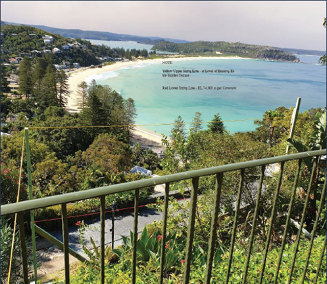
Figure 3: Extract from Planning Proposal - Site
picture with height poles
Pittwater Local
Environmental Plan 1993
On 30 March 2007, 6A Mitchell Road was
rezoned under the Pittwater Local Environmental Plan 1993, from Zone No. 2 (a)
(Residential “A”) to Zone No 6 (a) (Existing Recreation
“A”). This included the viewing platform land above 74.5 AHD.
The lower allotment containing the dwelling
house, 6 Mitchell Road, remained Zone No. 2 (a) (Residential
“A”). This includes the portion of land below 74.5 AHD.
An extract of the zoning map, obtained from
the adopted Bible Garden Plan of Management, is in Figure 4.
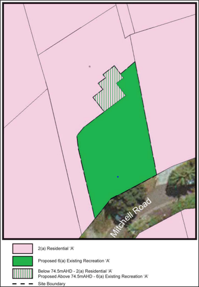
Figure 4: Zoning
under Pittwater LEP 1993
Pittwater Local
Environmental Plan 2014
On 26 June 2014, the Pittwater Local
Environmental Plan 2014 (Pittwater LEP 2014), prepared under the Standard LEP
Template, came into effect, repealing Pittwater LEP 1993.
This resulted in the properties being zoned
as follows:
· 6 Mitchell Road, Palm Beach (the subject of the Planning Proposal)
– The land was rezoned from Zone No. 2 (a) (Residential “A”)
as follows:
· majority of the site is zoned C4 Environmental Living; and
· the portion of the site directly underneath the Bible Garden’s
viewing platform (below 74.5 AHD) became zoned RE1 Public Recreation.
· 6A Mitchell Road, Palm Beach was rezoned from Zone No 6 (a)
(Existing Recreation “A”) to RE1 Public Recreation.
An extract of the Pittwater LEP 2014 zoning map is in Figure 5.
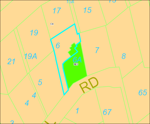
Figure 5: Zoning
Map Pittwater LEP 2014
Recent
Development Application
On 25 January 2021, Council received a
Development Application (DA2020/1596) for 6 Mitchell Road to construct a
dwelling house including a swimming pool, driveway, and garage. Components of
the dwelling house, primarily the garage and lift were proposed to be sited on
that portion of land zoned RE1 Public Recreation.
On 18 August 2021, the DA2020/1596 was
refused. The primary reason for refusal was that the residential development
proposed to be built on that portion of the site zoned RE1 Public Recreation is
prohibited under the zone.
Pre-Lodgment
Meeting
Following refusal of DA2020/1596,
pre-lodgement meetings were held between the landowner’s legal
representatives and Council on 19 August and 14 December 2021 to discuss the
RE1 zoning on the portion of the land.
Site
Description
The subject site, known as 6 Mitchell Road,
Palm Beach (Lot 1, DP 1086858), is a battle axe shaped lot located on the
northern side of Mitchell Road. Access to this property is provided via an
elevated driveway from Mitchell Road along the western (side) boundary. This
elevated driveway also provides access to 15 Florida Road, located north-east
of the subject site (see Figure 6).
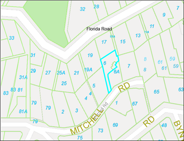
Figure 6:
Locality Map
An existing dwelling is located on the
lower portion of the subject site. Pedestrian access into the dwelling from
Mitchell Road is via stairs sited beside the elevated driveway.
6 Mitchell Road is Zoned C4 Environmental
Living and RE1 Public Recreation under the Pittwater LEP 2014. The surrounding
Properties are a mix of established low density residential areas zoned C4
Environmental Living.
The Bible Garden at 6A Mitchell Road not
only abuts this land but overhangs directly above a portion of the subject site
from a depth of 74.5 AHD. 6A Mitchell Road (inclusive of the overhang) is a
locally listed heritage item. Due to the nature of the stratum subdivision, the
portion of the subject site underneath the Bible Garden overhang is also listed
as a heritage item. A picture showing the relationship between the Bible Garden
overhang and the portion of 6 Mitchell Road underneath is in Figure 7 (shown
in the white bubble).
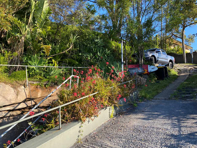
 Figure 7: Location of Bible Garden overhang between 6 and 6A Mitchell Road
The Proposal
On 12 September 2022, Council received a
proponent-initiated Planning Proposal for 6 Mitchell Road, Palm Beach (Lot 1,
DP 1086858), submitted by Planning Hub.
The intent of the Planning Proposal is to
amend the Pittwater LEP 2014 to include an additional permitted use of a
‘dwelling house’ on the RE1 zoned portion of the site (being the
land below the Bible Garden viewing platform) to facilitate future residential
development in line with the intended use of the site as outlined in the Heads
of Agreement, signed 9 February 2004, between the Trustees of the Bible Garden
and Pittwater Council.
A provision is also proposed restricting
the building height of any future residential development on the site to 74.5
AHD, ensuring that the views of Palm Beach from the Bible Gardens are
preserved.
Assessment Of
Planning Proposal
An assessment of the Planning Proposal was
undertaken in accordance with the Department of Planning and
Environment’s Local Environmental Plan Making Guideline 2022, as follows.
Part 1- Objectives or Intended
Outcomes
The objectives and intended outcomes of the
Planning Proposal are to seek an amendment to PLEP 2014 to allow a section of
the subject site, zoned RE1 Public Recreation, to permit development for the
purposes of a dwelling house; and to seek that residential development on the
site cannot exceed a height of 74.5 AHD.
Applying the rules of the Standard LEP
Template required that land, including land beneath 74.5 AHD under the Bible
Garden overhang was zoned RE1 Public Recreation under Pittwater LEP 2014.
This change in zoning under Pittwater LEP
2014 resulted in the prohibition of a dwelling house on that portion of site
zoned RE1, contrary to the signed Heads of Agreement.
The Planning Proposal seeks to rectify this
zoning prohibition, to permit a dwelling house on a small portion of the land.
This is considered reasonable and in keeping with the signed Heads of Agreement
upon which Council received dedication of the Bible Garden land.
Imposing a building height of 74.5 AHD for
any future residential development on the subject site is also appropriate and
is consistent with the signed Heads of Agreement.
The Planning Proposal is site-specific and
can only be applied to 6 Mitchell Road, Palm Beach.
Part 2 – Explanation of
Provisions
The Planning Proposal amends the following
provisions of the Pittwater LEP 2014:
· Additional Permitted Uses Map for the subject site (Sheet APU_015)
to identify the portion of the site zoned RE1 Public Recreation for additional
permitted uses referenced in Schedule 1 of LEP.
· Schedule 1 to include a provision relating to the subject site that
would permit development for the purposes of a dwelling house. Schedule 1 is to
also detail that any future residential development on the site cannot exceed a
height of 74.5 AHD.
The amendments
support the creation of an additional permitted use for a dwelling house on
that portion of the land currently zoned RE1. This is best served by amending
the Additional Permitted Uses Map, to identify 6 Mitchell Road as referenced in
Schedule 1 of Pittwater LEP 2014.
Currently, the Height of Building Map and
Clause 4.3 Height of Buildings under Pittwater LEP 2014 applies to the land.
The proposal to require that any future residential development on the site
cannot exceed a height of 74.5 AHD by way of Schedule 1 is appropriate. This
will apply to all of 6 Mitchell Road and not just the portion of the site zoned
RE1. This restriction will apply in addition to the existing height provisions
of the Pittwater LEP 2014 which will remain unchanged.
The measurement of 74.5 AHD ensures that
any future development is below the level of the Bible Gardens and thus retains
significant and important views to the ocean, Pittwater and beyond.
Accordingly, it is proposed to amend the
Explanation of Provisions to read as follows:
a) Amend the Pittwater LEP 2014 Additional Permitted Uses Map for the
subject site 6 Mitchell Road, Palm Beach (Sheet APU_015) to identify the site
for additional permitted uses referenced in Schedule 1 of Pittwater LEP 2014.
b) Amend Schedule 1 of the Pittwater LEP 2014 to include a provision
for 6 Mitchell Road, Palm Beach:
· Permit development for the purposes of a dwelling house on that
portion of the land zoned RE1 Public Recreation.
· In addition to any other provision in this Plan, any future residential
development on 6 Mitchell Road, Palm Beach cannot exceed a height of 74.5 AHD.
Part 3 – Justification
Strategic Merit
Section A – Need for the Planning
Proposal
Q1. Is the
Planning Proposal a result of an endorsed Local Strategic Planning Statement, Strategic
Study or report?
The Planning Proposal is not the result of
the Northern Beaches Local Strategic Planning Statement, strategic study, or
report.
The proposal is consistent with the Heads
of Agreement signed in 2004 by Pittwater Council and the then owners of the
land. It is also consistent with several objectives and priorities within the
Northern Beaches Local Strategic Planning Statement - Towards 2040 (detailed in
Q4 below).
The proposal will enable appropriate
residential development that recognises the heritage significance of the site
and surrounding area, and will not adversely impact on the ecological,
cultural, or scenic significance of the site and surrounding area.
Q2. Is
the Planning Proposal the best means of achieving the objectives or intended
outcomes, or is there a better way?
Yes, a Planning Proposal is the only way of
achieving the objectives and intended outcomes for this site that is also
consistent with the signed Heads of Agreement.
The signed Heads of Agreement included a condition
that any future residential development cannot exceed 74.5 AHD.
Allowing a ‘dwelling house’ as
an additional permitted use, on a minor portion of the site that is zoned RE1
Public Recreation will not result in any of the following:
· a practical reduction of land that is to be used for public open
space or recreational purposes;
· endangering and weaken the natural environment for recreational
purposes; and
· diminishing public use of, or access to, public open space
resources.
Section B - Relationship to Strategic
Planning Framework
Q3. Will
the Planning Proposal give effect to the objectives and actions of the
applicable regional, or district plan or strategy (including any exhibited
draft plans or strategies)?
The Planning Proposal is consistent with
both the Greater Sydney Region Plan and the North District Plan.
The Planning Proposal will also achieve the
following objectives under the Greater Sydney Region Plan:
· Objective 7: Communities are healthy, resilient and socially
connected
· Objective 13: Environmental Heritage is identified, conserved and
enhanced
· Objective 28: Scenic and cultural landscapes are protected
· Objective 31: Public Open Space is accessible, protected and
enhanced
Q4. Is
the planning proposal consistent with a council’s local Strategy or other
local strategic plans?
The Planning Proposal is consistent with
the Northern Beaches Local Strategic Planning Statement (LSPS). The additional
height restriction will ensure that views to Palm Beach from the Bible Garden
are preserved and there is minimal impact on the heritage significance of the
Bible Garden.
The Planning
Proposal is most consistent with the following priorities of the LSPS:
· Priority 6 - High quality open space for
recreation
· Priority 11 - Community facilities and services
that meet the changing community needs
· Priority 18 - Protected, conserve and celebrated
heritage.
· Priority 29 - A thriving, sustainable tourism
economy
Q5. Is
the planning proposal consistent with applicable State Environmental Planning
Policies (SEPPs)?
The Planning
Proposal is not inconsistent with the State Environmental Planning Policies
(SEPP) as listed in the Table below:
|
SEPPs (as at March 2022)
|
|
Focus Areas
|
State Environmental Planning Proposal
|
Applicable
|
Is the Planning Proposal consistent
with SEPP?
|
|
Housing
|
Housing SEPP
|
N/A
|
N/A
|
|
Transport and Infrastructure
|
Transport and Infrastructure SEPP
|
N/A
|
N/A
|
|
Primary Production
|
Primary Production SEPP
|
N/A
|
N/A
|
|
Biodiversity and Conservation
|
Biodiversity and Conservation SEPP
|
YES
|
YES
|
|
Resilience and Hazards
|
Resilience and Hazards SEPP
|
YES
|
YES
|
|
Industry and Employment
|
Industry and Employment SEPP
|
N/A
|
N/A
|
|
Resources and Energy
|
Resources and Energy SEPP
|
N/A
|
N/A
|
|
Planning Systems
|
Design Quality of Residential Apartment
Development
|
N/A
|
N/A
|
|
Precinct SEPPs
|
|
|
· Eastern Harbour City SEPP
|
N/A
|
N/A
|
|
· Western Parkland City SEPP
|
N/A
|
N/A
|
|
· Central River City SEPP
|
N/A
|
N/A
|
|
· Regional SEPP
|
N/A
|
N/A
|
|
Codes SEPP
|
N/A
|
N/A
|
|
No.65
|
Design Quality of Residential Apartment
Development
|
N/A
|
N/A
|
|
|
State Environmental Planning Policy
(Building Sustainability Index: BASIX) 2004
|
YES
|
YES
|
|
|
(State Environmental Planning Policy
(Exempt and Complying Development Codes) 2008
|
YES
|
YES
|
Q6. Is the Planning Proposal
Consistent with Applicable Ministerial Directions (Section 9.1 Directions)?
Apart from the Ministerial Direction 1.4
Site Specific Provisions, the Planning Proposal is consistent with the
applicable Local Ministerial Directions. Direction 1.4 Site Specific
Provisions, reads as follows:
(1) A planning proposal that will amend
another environmental planning instrument in order to allow particular
development to be carried out must either:
(a) allow that land use to be carried out in the
zone the land is situated on, or
(b) rezone the site to an existing zone already
in the environmental planning instrument that allows that land use without
imposing any development standards or requirements in addition to those already
contained in that zone, or
(c) allow that land use on the relevant land
without imposing any development standards or requirements in addition to those
already contained in the principal environmental planning instrument being
amended.
A planning proposal may be inconsistent
with the terms of this direction only if the relevant planning authority can
satisfy the Planning Secretary (or an officer of the Department nominated by
the Secretary) that the provisions of the planning proposal that are
inconsistent are of minor significance.
The Planning Proposal seeks to allow an
additional permitted use of ‘dwelling house’ on that part of the
land zoned RE1 Public Recreation and add an additional height restriction to
the land.
The proposed amendments are consistent with
the Heads of Agreement and the inconsistency with Direction 1.4 Site Specific
Provisions is of minor significance and limited to this property.
Site-Specific Merit
Section C- Environmental, Social and
Economic Impact
Q7. Is
there any likelihood that critical habitat or threatened species, populations
or ecological communities, or their habitats, will be adversely affected as a
result of the proposal?
6 Mitchell Road Palm Beach is identified on
the Pittwater LEP 2014 Biodiversity Map - Sheet BIO_015, and as a result calls
up Clause 7.6 Biodiversity under the LEP.
A Flora and Fauna Assessment by EcoLogical
Australia (May 2022) and an Arborist Report by Arbosaw (June 2022) accompanied
the Planning Proposal application.
The Flora and Fauna Assessment undertook a
threatened species ‘test of significance’ assessment incorporating
the following:
· On ground surveys on 18 August and 3 September 2019, and 14 May
2022.
· Bionet searches for flora, fauna and endangered populations to
identify if there were previous records of threatened species occurring within
the local area using a 10km radius around the site.
· A review of the Planning Proposal and the proposed development it
seeks to enable was evaluated for potential environmental impacts.
No threatened
plant or animal species were found on and within immediate vicinity of this
property.
Council’s Senior Environment Officer
- Biodiversity advised as follows:
The Biodiversity Planning team do not
raise any other issues or concerns in relation to the current Planning
Proposal.
I note the updated Flora & Fauna
Assessment which has assessed the biodiversity values of the portion of the
site zoned RE1 Public Recreation, and generally agree with the report findings,
namely that a significant impact to the environment is unlikely and the NSW
biodiversity Offset Scheme is not triggered. A range of suitable management and
mitigation measures are also detailed within the Report that could be applied
to any future development of the site.
The Planning Proposed is not likely to
adversely impact on critical habitat, threatened species, populations, or
ecological communities.
The Arborist Report concluded that the
Planning Proposal is suitable from a tree impact perspective provided the
recommendations are implemented during the approval of any future Development
Application.
Q8. Are
there any other likely environmental effects as a result of the planning
proposal and how are they proposed to be managed?
Geotechnical
The subject site is identified as being a
Geotechnical Hazard H1 on the Geotechnical Hazard Map. A Geotechnical
Report prepared by Davies Geotechnical Consulting Engineers (July 2022)
accompanied the Planning Proposal application.
This report concludes that the geotechnical
conditions of the site will not affect consideration of the Planning Proposal.
Heritage
A Heritage report by Weir Phillips (21 July
2022) accompanied the Planning Proposal application. The report concluded that
the proposed additional permitted use within the small portion of land zoned
RE1-Public Recreation will have no impact on the significance of the adjoining
heritage item (Bible Garden) for the following reasons:
· The proposed additional permitted use is in character with the
original concept scheme envisaged when the site was subdivided and sold as part
of the Heads of Agreement between Pittwater Council and the Trustees of the
Bible Garden.
· The steep topography of the northern portion of the subject site is
unusable by patrons of the Bible Garden. An additional permitted use in this
portion of the site allows for a construction of a dwelling with a flat top
structure (potential garage).
· Additional permitted use within the RE1 zoning will not result in a
built form that when viewed from the most significant points at Mitchell Road
and from within the Bible Gardens the dwelling will be concealed by the
existing topography. There will be no visual impact from this perspective.
· The character of the Bible Garden, as a site enjoyed for quiet
contemplation and appreciation of the magnificent outlook towards Palm Beach
will be unaffected by the proposed additional permitted use within the RE1
zoning.
· The proposed additional permitted use within the RE1 zoning is
unlikely to reduce the user’s ability to interpret the cultural landscape
of the Bible Garden within its context.
· From Palm Beach and surrounds, a new dwelling built as a result of
the additional permitted use in RE1 would be visible as one of a number of
residential developments within the escarpment behind Palm Beach as a result of
the proposed additional permitted use. Any new dwelling constructed would be
visible in the landscape from these viewpoints but will have a lessened visual
impact due to the scale and constrained nature of the site in comparison to
other nearby residential developments. The visual impact from this perspective
is considered to be minor.
· No other heritage items in the vicinity will be affected by future
built form constructed as part of the planning proposal owing to the separation
of these items from the subject site.
Council’s
Heritage Officer concurs with the report’s conclusions and supports the
Planning Proposal from a heritage perspective as it will:
· Enable a dwelling to be constructed as envisaged by the Heads of
Agreement between Council and the Bible Garden Trust; and
· Not impact upon the heritage significance of The Bible Garden; and
· Not impact upon important significant views from the garden out to
Pittwater, Palm Beach and beyond.
View Loss
The proposal provided a detailed account of
a study conducted in consultation with the Committee of the Friends of the Palm
Beach Bible Garden. Height poles were installed to determine the potential
impact of any future development on the RE1 zoned land. The study concluded
that no portion of future residential development on this land will impede on
existing views from the Bible Garden based on topography of the site and the
existing covenants over the land.
The Planning Proposal seeks to add a height
restriction for any future residential development on 6 Mitchell Road. This is
in addition to the existing height provisions in the Pittwater LEP 2014 and
will ensure that views from the Bible Garden are preserved and consistent with
the signed Heads of Agreement.
Q9. Has
the Planning Proposal adequately addressed any social and economic effects?
The Planning Proposal will facilitate
residential development on the whole of 6 Mitchell Road, consistent with the
signed Heads of Agreement.
The proposal will not result in additional
dwellings being permitted on the land. It will facilitate a dwelling house, and
development ancillary to a dwelling (e.g., a garage), to be permissible on that
part of the land zoned RE1.
Limiting the height of future residential
development on the land ensures no obstruction of views from the Bible Garden.
This allows the land to be used and enjoyed by the owners and the community.
Section D - State and Commonwealth
Interests
Q10. Is there
adequate public infrastructure for the Planning Proposal?
6 Mitchell Road is an existing serviced
property within an established neighborhood. The Planning Proposal will not
result in additional dwellings being permitted on the land and will not require
additional public infrastructure.
Q11.
What are the views of state and Commonwealth public authorities consulted in
accordance with Gateway determination?
If the Planning Proposal progresses and
receives a Gateway Determination, the following public authorities will be
consulted:
· Sydney Water
· Ausgrid, and
· NSW Office of Environment and Heritage.
CONSULTATION
The Planning Proposal submitted by the proponent was
initially placed on non-statutory public exhibition for 14 days, from 28
September to 13 October 2022, in accordance with the Northern Beaches Community
Participation Plan. Following a request from a submitter, the public exhibition
period was extended to 21 October 2022. The public exhibition comprised:
· Notification letters to adjoining landowners and occupiers
· Email to community members who had registered their interest in the
project
· An updated Council ‘Your Say’ page with relevant
information; and
· Inclusion in Council’s Community News email.
Six (6) submissions were received.
The issues raised in submissions included:
· Request for the garage to be lowered
· Vegetation that will feature on garage roof should be at maximum
development height
· New structure will obscure view
· Unlawful public exhibition and Planning Proposal
· The proposed amendments are unclear
· Extension of public exhibition
· Planning Proposal is unlawful.
Issues relating to landscaping and
the potential design of the garage are not relevant to the Planning Proposal
and will be considered in any future Development Application. The Planning
Proposal has been lawfully prepared and considered in accordance with all
statutory requirements.
A summary of the submissions and responses to the issues
raised is in Attachment 3. These issues do not warrant the rejection of the
Planning Proposal.
Local Planning
Panel
On 14 December 2022, an assessment of the
Planning Proposal was presented to the Northern Beaches Local Planning Panel.
The proceedings in Brief from the meeting included the following comments:
At the public
meeting Counsel for an objector submitted that: (a) there were two planning
proposals before the Panel, one by The Planning Hub on behalf of the applicant
and the other by Council as set out in Attachment 2 to the Council assessment
report; (b) that the former was beyond power under the Environmental Planning
and Assessment Act 1979 but that the latter was within power and the Panel
could advise in respect of the latter; (c) that the Panel should reject the
former and advise Council only in respect to the latter. The Panel considers
that there is only one planning proposal before it, namely the Council’s planning
proposal set out in Attachment 2 to the Council assessment report. The Panel
will advise Council only in respect of that planning proposal.
Subsequently, the Planning Panel
recommended:
That the Northern Beaches Local Planning Panel recommends
that Council support the planning proposal set out in Attachment 2 to the
Council assessment report to permit a dwelling house limited to a building
height of RL 74.5 AHD as an additional permitted use on 6 Mitchell Road Palm
Beach, for the reasons presented in the assessment report, subject to the
following:
The Panel suggests that the additional clauses in
Schedule 1 of the Pittwater Local Environment Plan should read to the following
effect:
Use of certain land at 6
Mitchell Road, Palm Beach
(1) This
clause applies to land at 6 Mitchell Road, Palm Beach, being Lot 1. DP1086858
and identified as on the Additional Permitted Uses Map.
(2) Development
on the part of 6 Mitchell Road, Palm Beach zoned RE1 for the purposes of a
dwelling house, not exceeding RL 74.5AHD in height, is permitted with
development consent.
(3) The
height limit restriction of RL 74.5AHD also applies to the remainder of 6
Mitchell Road, Palm Beach, currently zoned C4.
(4) Subject
to the restriction imposed by clause 3, the remainder of 6 Mitchell Road, Palm
Beach continues to be subject to the development height controls in clause 4.3
of the Pittwater Local Environmental Plan.
Vote: 4/0
The Planning Proposal has been amended in line with the
suggestion provided by the Local Planning Panel.
The minutes of the Local Planning Panel meeting are in
Attachment 4.
External
Probity Adviser
On 24 October 2022, Council engaged the services of external
probity adviser Charles Kendall Australia to oversee Council’s assessment
of the Planning Proposal. Probity advice was sought to manage any potential or
perceived conflict of interest arising from the assessment of a Planning
Proposal on land adjacent to the Council-owned Bible Gardens.
Charles Kendall Australia has undertaken an audit of the
assessment process. The audit report is provided in Attachment 5. The audit
report concluded that the were no probity concerns with the assessment of the
Planning Proposal.
TIMING
It is anticipated that the timeframe for completion of the
Planning Proposal is approximately 12-18 months from the date of
Council’s approval.
Following the issue of a Gateway Determination, Council will
be required to formally exhibit the Planning Proposal for 28 days. The outcomes
of this exhibition will be reported back to Council for consideration.
LINK TO STRATEGY
The Planning Proposal relates to the
following goals of the Northern Beaches Community Strategic Plan 2040 outcome
of:
· Community and belonging - Goal 7 Our diverse community is supported
to participate in their chosen cultural life
· Community and belonging - Goal 8 Our community feels safe and
supported
· Community and belonging - Goal 9 Our community is inclusive and
connected
· Housing, places and spaces - Goal 11 Our local centres are vibrant
and healthy, catering for diverse economic and social needs
· Partnership and participation - Goal 22 Our Council builds and
maintains strong partnerships and advocates effectively on behalf of the
community
financial considerations
The Planning Proposal is a proponent-initiated application.
The proponent has paid the assessment fees stipulated in Council’s Fees
and Charges 2022/23.
The recommendations of this report pose no financial impact
on Council.
social considerations
The proposal seeks to rectify an anomaly unique to this site
and is consistent with the signed Heads of Agreement.
The Planning Proposal will maintain the existing views from
the Bible Garden and is not anticipated to have any adverse social impacts.
environmental considerations
An assessment of the Planning Proposal has determined that
it is unlikely to have any adverse environmental impacts on the subject site or
surrounding land.
governance and risk
considerations
The Planning Proposal has been assessed is accordance with
all statutory requirements.
Independent probity advice was sought to manage any
potential or perceived conflict of interest arising from the assessment of the
Planning Proposal. The audit report concluded that the were no probity concerns
with the assessment of the Planning Proposal.
|

|
Report To Ordinary Council MEETING
|
|
ITEM NO. 12.3 - 28 March 2023
|
|
ITEM 12.3
|
Public
Exhibition of Draft Planning Agreement at 321-331 Condamine Street, Manly
Vale
|
|
REPORTING
MANAGER
|
Executive
Manager Strategic & Place Planning
|
|
TRIM
file REF
|
2022/658140
|
|
ATTACHMENTS
|
1 ⇨Offer to Enter into Planning Agreement (Included In
Attachments Booklet)
2 ⇨Draft Planning Agreement (Included In Attachments
Booklet)
|
PURPOSE
To seek Council’s endorsement to
publicly exhibit the draft Planning Agreement at
321-331 Condamine Street, Manly Vale.
Executive Summary
On 22 December 2021, Manly Vale Developments
No. 2 Pty Ltd submitted an offer to enter into a Planning Agreement (the
‘Offer’) with Northern Beaches Council for 321-331 Condamine
Street, Manly Vale to dedicate land and construct and widen a laneway at the
rear of the site (Somerville Place).
The Offer was associated with a development
application which subsequently received a deferred commencement development
consent from the Land & Environment Court on 11 February 2022 for
demolition works and the construction of a four-storey shop-top housing
development consisting of four (4) retail tenancies on the ground floor,
twenty-six (26) residential apartments over three levels and a basement carpark
for forty-three (43) vehicles.
Clarification was subsequently sought from
Manly Vale Developments in relation to several details associated with the
Offer.
An updated Offer was received on 12 August
2022, involving:
· Dedication of land 54.6m2 in area (1.435m wide x 38.075m
long) to Council free of charge for the Somerville Place road widening. The dedication will result in a 6m-wide road reserve.
· The dedication will occur via a Plan of Subdivision which will be
registered once all building and civil works are complete and prior to issue of
any Occupation Certificate.
· A right of footway on privately owned land will be created as an
easement in gross (limited in height) in favour of Council.
Council’s Development Contributions
Panel has considered the Offer and determined there is a public benefit arising
from the Offer.
A draft Planning Agreement has been
prepared and is provided to Council for consideration.
If Council agrees, the draft Planning
Agreement and supporting documentation will be publicly exhibited for 28 days
in accordance with statutory requirements. The outcomes of the public
exhibition will be reported to Council.
RECOMMENDATION OF ACTING Director Planning and
Place
That:
1. Council
place the draft Planning Agreement and supporting documentation on public
exhibition for a minimum of 28 days.
2. The outcomes of the public exhibition of the draft Planning Agreement be reported to Council.
BACKGROUND
Planning Agreements are a legal arrangement
made between a developer and Council to facilitate the delivery of a public
benefit. Public benefits may include the dedication of land at no cost to
Council, the payment of a monetary contribution, and/or the provision of
infrastructure works.
Planning Agreements are voluntary and
initiated by the developer. The current legal and procedural framework for
Planning Agreements is set out in Division 7.1 of Part 7 of the Environmental
Planning and Assessment Act 1979 (the ‘Act’) and Division 1 of Part
9 of the Environmental Planning and Assessment Regulation 2021.
In June 2022, Council
adopted a Planning Agreements Policy (Council’s Policy) and
accompanying Guidelines to help guide developers on Council’s preferred
approach to Planning Agreements. It identifies legal and procedural obligations
to be satisfied by the developer, and details the criteria Council uses to
assess an Offer.
Council’s assessment of an Offer and
progression of a Planning Agreement to execution will be in accordance with
Council’s Policy and the Planning Agreements Practice Note (Department of
Planning, Industry and Environment, February 2021).
The Site
The land
that is the subject of the Offer is known as 321-331 Condamine Street, Manly
Vale (the ‘subject site’) and comprises five (5) allotments:
· Lots 20, 21, 22 and 25 in Deposited Plan 11320, and
· Lot 123 in Deposited Plan 737259.
The
subject site is located on the western side of
Condamine Street and is at the north-western corner of the Condamine
Street-Sunshine Street intersection.
The subject site is regular in shape with a
frontage of 36m to Condamine Street, a frontage of 31m to Sunshine Street, a
frontage of 38m to Somerville Place, and a depth of 34m. This land has a total
surveyed area of 1,274m2.
All land within the subject site is zoned
B2 Local Centre under the Warringah Local Environmental Plan 2011.
Access into the subject site comprises
pedestrian access from Condamine Street and vehicular access is from the rear
lane by entering Somerville Place.
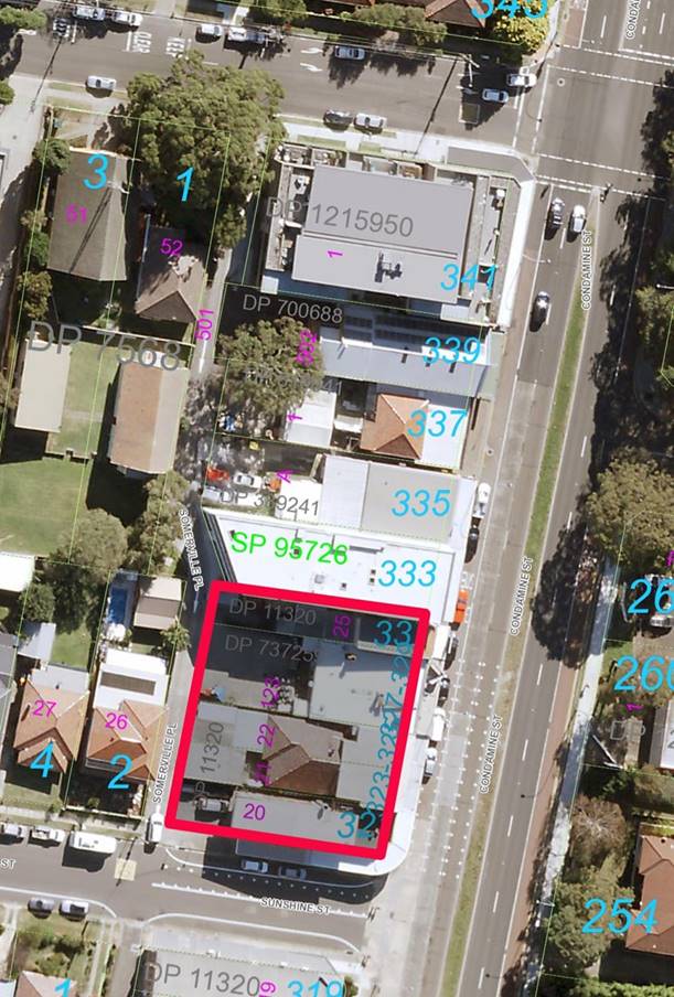
Figure 1:
Location Map, 321-331 Condamine Street, Manly Vale
Vehicular Access to Somerville Place
Somerville Place is a one-way laneway that runs parallel to
Condamine Street and provides rear lane access to the properties fronting
Condamine Street. Access into Somerville Place can only be gained via
King Street, with vehicles travelling in a southbound direction to exit onto
Sunshine Street.
Somerville Place is a public road and has a varied width. Currently, the section of Somerville Place immediately abutting the
rear of the subject site is approximately 4.56m wide. Adjacent to 339
Condamine Street, Somerville Place is only 3m wide. Some sections of Somerville
Place are already 6 metres wide, including:
• 341-343 Condamine Street – the subject of a Planning Agreement
between the former Warringah Council and Joesandra Pty Ltd and CES Developments
Pty Ltd. This agreement was executed on 30 June 2016. A 2.34m-wide section of
land for road widening was transferred to Council on 17 May 2016.
• 333 Condamine Street, which is the property immediately north of the
subject properties.
The land dedication proposed as part of the Offer will
result in an increased road reserve width of 6m adjacent to the subject site.
The Approved Development (DA2020/0824)
On 11 February 2022, the Land &
Environment Court approved a development application (DA2020/0824) on the
subject site, subject to a deferred commencement condition. The deferred
commencement consent is for demolition works and the construction of a
four-storey shop-top housing development consisting of four (4) retail
tenancies on the ground floor, twenty-six (26) residential apartments over
three levels and a basement carpark for forty-three (43) vehicles.
The development consent also includes the
reconstruction and widening of Sommerville Place to provide a 6m-wide road
reserve adjacent to the subject site. A Planning Agreement is the legal
mechanism required to facilitate the dedication of land containing the widened
road to Council.
The deferred commencement condition reads
as follows:
“1 Planning
Agreement for the Dedication of Land
The developer
shall enter into a Planning Agreement (PA) with Northern Beaches Council
pursuant to section 7.4 of the Environmental Planning and Assessment Act, 1979
to dedicate a 1.4m wide x 38.075m long strip of land adjacent to Somerville
Place for the purpose of road widening and consistent with the
developer’s offer dated 22 December 2021.
The Executed
Planning Agreement is to be in place before this condition is satisfied.
Note: Please
be advised that no decision as to whether Council will enter into a Planning
Agreement has been made and there is no representation that such a decision
will be made until the draft Planning Agreement has been exhibited, assessed
and determined by Council in accordance with the Environmental Planning and
Assessment Act, 1979.
Evidence
required to satisfy the deferred commencement condition must be submitted to
Council within two (2) years of the date of this consent, or the consent will
lapse in accordance with Section 95 of the Environmental Planning and
Assessment Regulation 2000.
This evidence
is to be submitted along with a completed ‘Deferred Commencement Review
Form’ (available on Council’s website) and the application fee, as
per Council’s Schedule of Fees and Charges.”
Offer to Enter
into a Planning Agreement
On 22 December 2021, Manly Vale
Developments No. 2 Pty Ltd (the ‘Developer’) lodged an Offer to
Enter into a Planning Agreement (the ‘Offer’). On initial review of
the Offer, several inconsistencies were identified. The Developer was requested
to address the following deficiencies:
1. Insufficient details on the proposed land to be dedicated
particularly regarding dimensions.
2. Inconsistencies between engineering plans and the plan of land
dedication.
3. Clarification on intent to dedicate footpath which is on private
land.
On 12 August
2022, an updated Offer was received. The Offer (Attachment 1) proposes:
· Dedication of land 54.6m2 in area (1.435m wide x 38.075m
long) to Council free of charge for Somerville Place road widening. The
dedication of land will occur by registration of the Plan of Subdivision once
the Developer has reconstructed Sommerville Place and prior to issue of any
Occupation Certificate.
· A right of footway will be created as an easement in gross (limited
in height) on the footpath located adjacent to the road reserve of Somerville
place, on land that will remain in private ownership.
The land to be
dedicated to Council is shown by notation (R) in Figure 2. The easement is
identified by notation (A).
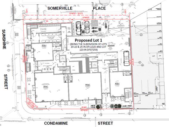
Figure 2: Land to be dedicated to Council
The Public
Benefit of the Offer
In accordance
with its charter, Council’s Development Contributions Panel (the
‘Panel’) has considered an assessment of the Offer and determined
there is public benefit arising from the Offer, being:
· The Somerville Place road reserve adjacent to the site is currently
4.56m wide. Dedication of land and road widening will result in a 6m-wide
reserve that will improve the efficiency of the existing road and will
contribute to the future anticipated two-way operation, improving traffic
movements. The road will be constructed by the Developer to Council’s
standards and will help improve the road conditions in that section of
Somerville Place.
· An easement will be provided that will allow public access over
privately owned property. Currently, there is no footpath along this section of
the Somerville Place road reserve. Public access, by way of a registered
easement over the privately-owned land (that will contain a footpath
constructed under DA2020/0824) provides a safe pedestrian access to the local
road network. Construction of the footpath will be as per Council approved
standards and will provide appropriate stormwater management.
At its meeting of 20
September 2022, the Panel agreed in-principle to support the Offer and
to allow the negotiation and preparation of the draft Planning Agreement. At
this meeting the Panel recommended:
“That:
1. The
Development Infrastructure Contributions Panel (the ‘Panel’) give
in-principle support to the Offer to Enter into a Planning Agreement subject
to:
A. The
terms for the draft Planning Agreement being negotiated with the developer,
being:
i. Council
staff inspect the civil works – road reserve and footpath – during
and at final stage/completion and are duly satisfied before the land dedication
is effected and easement registered.
ii. An
application for Subdivision Certificate is lodged with Council in regard to the
land dedication – public road reserve – and the easement for public
access in regard to the private land containing a section of footpath.
B. Council’s
Principal Development Infrastructure Officer be nominated as Council’s
Responsible Officer in negotiating the terms of obligations listed in
recommendation 1A, in accordance with Council’s Planning Agreements
Policy.
C. Legal
Counsel is instructed to prepare the draft Planning Agreement in accordance
with the terms negotiated by Council’s Responsible Officer.
D. The
draft Planning Agreement is to be distributed to the Panel ahead of the matter
being reported to Council, with the view to recommending it be placed on public
exhibition.
2. The
Development Contributions Working Group be advised of the Panel
decision.”
The Draft Planning Agreement
The draft Planning Agreement (Attachment 2)
was prepared by Council and has been reviewed and agreed by the Developer. The
draft Planning Agreement encompasses the following elements:
1. Dedication of land to Council free of charge
2. Easement for public access over private land
3. Timing of the Developer’s obligations, including appropriate
inspections by Council staff.
CONSULTATION
The Development Infrastructure
Contributions Panel has reviewed the draft Planning Agreement to ensure it is
consistent with its recommendations of 20 September 2022.
If the Council
agrees, the draft Planning Agreement and supporting
documents will be publicly exhibited for 28 days in accordance with statutory
requirements.
TIMING
If the Council agrees, the public
exhibition will commence following the Council’s decision. The outcomes
of the public exhibition will be reported back to Council for consideration.
LINK TO STRATEGY
This report relates to the Community
Strategic Plan outcomes of:
· Places for People - Goal 8: Our neighbourhoods inspire social
interaction, inclusion and support health and wellbeing.
· Transport and Infrastructure - Goal 16: Our integrated transport
networks meet the needs of our community.
· Good Governance - Goal 19: Our Council is transparent and trusted to
make decisions that reflect the values of the community.
· Participation and Partnership - Goal 22: Our Council builds and
maintains strong partnerships and advocates effectively on behalf of the
community.
financial considerations
The draft Planning Agreement facilitates
the dedication of land and an easement for public access at no cost to Council.
The Developer has provided a valuation report for the land to be dedicated. The
report identifies that this land is valued at $491,400.
All costs associated with the preparation
and execution of this Planning Agreement will be borne by the Developer.
The draft Planning Agreement does not
exclude the Developer from paying the development contributions imposed under
Condition 7 of the development consent for the subject properties.
social considerations
The draft Planning Agreement facilitates
the dedication of 54.6m2 of land to Council for the purpose of road
widening at Somerville Place. The dedication of land and provision of a
footpath on private land adjacent to Somerville Place facilitates a safe and
accessible pathway which is a social benefit for future users of this footpath
and road.
environmental considerations
The road widening works on the land to be
dedicated to Council provides for appropriate management of stormwater and the
improved efficiency of the existing road condition.
governance and risk
considerations
An assessment of the Offer and preparation
of the draft Planning Agreement has occurred in accordance with Council Policy
and the Planning Agreements Practice Note (Department of Planning, Industry and
Environment, February 2021).
The draft Planning Agreement has been
prepared in accordance with the legislative requirements of Division 7.1 of
Part 7 of Environmental Planning and Assessment Act 1979 and Division 1 of Part
9 of the Environmental Planning and Assessment Regulation 2021.
The Panel has reviewed the draft Planning
Agreement to ensure it is consistent with the Panel’s recommendations of
20 September 2022.
|
|
Report To Ordinary Council MEETING
|
|
ITEM NO. 12.4 - 28 March 2023
|
|
ITEM 12.4
|
Adoption
of Draft Council- related Development Applications Policy
|
|
REPORTING
MANAGER
|
ACTING
Director Planning & Place
|
|
TRIM
file REF
|
2022/750933
|
|
ATTACHMENTS
|
1 ⇩Draft
Council-related Development Applications Policy
2 ⇩Council-Related
Development Application Conflict Of Interest Guidelines - DPIE
|
purpose
To adopt the draft Council-related Development Applications
Policy which has been developed in accordance with the Environmental
Planning and Assessment Amendment (Conflict of Interest) Regulation 2022.
executive summary
The Environmental Planning and
Assessment Amendment (Conflict of Interest) Regulation 2022 (the Amending
Regulation) will commence on 3 April 2023 and will amend the Environmental
Planning and Assessment Act 1979 and Environmental Planning and Assessment
Regulation 2021 (Regulation).
The Amending Regulation will amend the Act and the
Regulation so that, among other things:
· All ‘council-related development applications’ are
required to be publicly exhibited for a minimum of 28 days.
· A ‘council-related development application’ must not be
determined by the consent authority unless the council has adopted a conflict
of interest policy, and the council considers the policy in determining the
application.
A draft conflict of interest policy
entitled ‘Council-related Development Applications Policy’ has
been prepared to set out how Council will manage council-related development
applications. This policy is required to comply with the ‘Council-related
Development Application Conflict of Interest Guidelines’ published by the
Department of Planning and Environment.
Council-related development applications cannot be
determined after 3 April 2023 unless the Council has a conflict of interest
policy in place and has considered the policy in determining the application.
The term ‘council-related development
application’ is defined in the Amending Regulation to mean a development
application, for which a council is the consent authority, that is—
(a) made by or on behalf of the council, or
(b) for development on land –
(i) of which the council is an owner, a lessee or a licensee, or
(ii) otherwise vested in or under the control of the council.
The policy has been prepared to ensure
Council complies with the requirements of the Amending Regulation and can
determine impacted applications after 3 April 2023. The draft policy
broadly reflects current Council practices in managing conflict of interests
for council-related development applications.
RECOMMENDATION OF
ACTING DIRECTOR
Planning and Place
That:
1. Council
adopt the draft Council-related Development Applications Policy, to commence on
3 April 2023.
2. The
implementation of the new policy be monitored for 6 months with feedback sought
from the community, and a report on the implementation and review presented to
Council in October 2023.
BACKGROUND
The Environmental Planning and Assessment Amendment
(Conflict of Interest) Regulation 2022 (Amending Regulation) will commence
on 3 April 2023. Upon the commencement of the Amending Regulation, a ‘council-related development application’ must not be
determined unless:
(a) the council has adopted a conflict of interest policy; and
(b) the council considers the policy in determining the
application,
Accordingly, Council is required to have in
place a conflict of interest policy that sets out how council-related
development applications will be managed. The policy is required to comply with
the ’Council-related Development Application Conflict of Interest
Guidelines’ prepared by the Department of Planning and Environment
(Department).
The term ‘council-related development
application’ is defined in the Amending Regulation as follows:
“council-related
development application means a development application, for which a
council is the consent authority, that is:
(a) made by or on behalf of the council, or
(b) for development on land –
(ii) of which the council is an owner, a lessee or a licensee, or
(ii) otherwise vested in or under the control of the council.
Note— Land vested in or under the control of the council includes public
land within the meaning of the Local Government Act 1993.”
All council-related development applications will be
required to be publicly exhibited for a minimum of 28 days.
A draft conflict of interest policy titled
‘Council-related Development Applications Policy’ has been prepared
to ensure Council complies with the requirements of the Regulation and that
Council can determine impacted applications after 3 April 2023.
This draft policy has been prepared using the Department of
Planning and Environment’s template policy. In this template
policy the above definition in the Regulation is not used, and a different
definition for the purposes of the policy is used which defines:
Council related development
means development for which the council is the applicant developer (whether
lodged by or on behalf of council), landowner, or has a commercial interest in
the land the subject of the application, where it will also be the regulator or
consent authority.
The draft policy complies with the ‘Council-related
Development Application Conflict of Interest Guidelines’ published by the
Department. It sets out:
(a) The process Council will follow to identify whether a particular
development application is a council-related development application.
(b) The risk assessment process, specific categories of application and
management strategies in relation to those different categories.
(c) Which council-related development applications are of such minor
risk that they do not require a specific management response.
(d) Management strategies in relation to the undertaking of enforcement
and compliance activities related to council-related development.
In essence, the
draft policy proposes that any council-related development will be assessed
independently (as per the current practice) and that construction certificates
in respect of council-related development be certified by Private Accredited
Certifiers. All council-related development will continue to be referred to either
the Northern Beaches Local Planning Panel or the Sydney North Planning Panel
for determination as per Ministerial Directions and legislation.
CONSULTATION
Unless Council has adopted a
conflict of interest policy which complies with the ‘Council-related
Development Application Conflict of Interest Guidelines’ published by the
Department, Council may not determine a council-related development application
after 3 April 2023. These guidelines do not require public consultation
in relation to the adoption of a conflict of interest policy by councils.
Upon the commencement of the Amending Regulation, all council-related
development applications will be required to be publicly exhibited for a
minimum of 28 days.
TIMING
The policy must be in place by 3 April 2023, otherwise
Council may not determine a council-related development application.
LINK TO STRATEGY
This report relates to the Community
Strategic Plan Outcome of:
· Good governance - Goal 19 Our Council is transparent and trusted to
make decisions that reflect the values of the community
financial considerations
The administration of this policy
will have a minor financial impact on the cost of lodgement, assessment,
determination, and enforcement in respect of council-related
development.
Currently most council-related
development applications are already externally assessed, and all are
determined by the Northern Beaches Local Planning Panel or the Sydney North
Planning Panel in accordance with Ministerial Directions and legislation.
social considerations
There will no social impacts resulting from this policy.
environmental considerations
The policy will guide the determination of council-related
development applications under the Environmental Planning and Assessment Act
1979.
governance and risk
considerations
This policy is designed to manage conflicts of interest
associated with council-related development. The policy reflects
Council’s existing processes and provides a clear policy statement as to
the approach that will be adopted regarding conflict management in relation to
the assessment, determination, and construction of council-related development.
If the policy is not adopted, council-related development
applications may not be determined from 3 April 2023.
|

|
Attachment 1
Draft Council-related Development Applications Policy
|
|
ITEM NO. 12.4 - 28
March 2023
|
|
|
Attachment 2
Council-Related Development Application Conflict Of
Interest Guidelines - DPIE
|
|
ITEM NO. 12.4 - 28
March 2023
|
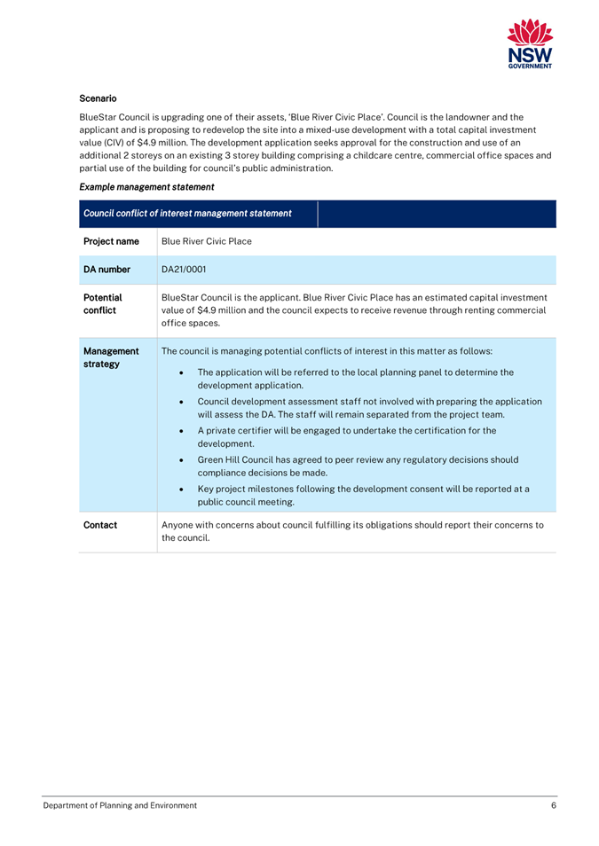
|
|
Report To Ordinary Council MEETING
|
|
ITEM NO. 12.5 - 28 March 2023
|
|
ITEM 12.5
|
Variations
to Development Standards Under Clause 4.6 of Local Environmental Plans
|
|
REPORTING
MANAGER
|
Executive
Manager Development Assessment
|
|
TRIM
file REF
|
2022/803072
|
|
ATTACHMENTS
|
1 ⇩Clause
4.6 - Variations to Development Standards
|
purpose
To report to
Council the variations to development standards granted under Clause 4.6 of the
Manly Local Environmental Plan (MLEP 2013), Pittwater Local
Environmental Plan (PLEP 2014) and Warringah Local Environmental Plan
(WLEP 2011), as required by the NSW Department of Planning and Environment.
executive summary
During the period 1 October 2022 to 31
December 2022, the following variations were granted:
· 34 variations under Clause 4.6 of Manly Local Environmental Plan
2013
· 10 variations under Clause 4.6 of Pittwater Local Environmental Plan
2014
· 16 variations under Clause 4.6 of Warringah Local Environmental Plan
2011.
RECOMMENDATION OF
ACTING Director
Planning and Place
That Council note the Development
Applications approved with variations to development standards during the
period 1 October 2022 to 31 December 2022.
BACKGROUND
The following
tables show all variations to development standards approved during the
period
1 October 2022 to 31 December 2022, for each of the LEPs in the Northern
Beaches LGA, and whether the determination was made by staff under delegated
authority or by a determination panel.
A total of 54
Development Applications were approved with a clause 4.6 request during the
quarter. During the quarter a total of 409 Development Applications were
approved – noting that the total number of applications (including
Modification and Review Applications) approved in the quarter totaled 546.
It should be
noted that the Land and Environment Court caselaw Merman Investments PTY LTD
v Woollahra Municipal Council [2021] NSWLEC 1582 in late 2021 changed the
way building height is measured when the site had previously been altered
through excavations. This has resulted in an increase in the number of
clause 4.6 requests received and determined.
Northern Beaches
Council has two external panels, being the Northern Beaches Local Planning
Panel (NBLPP) and the Sydney North Planning Panel (SNPP). The internal
determination panel is known as the Development Determination Panel (DDP).
It is noted that
Council is currently preparing a new Local Environmental Plan. The development
standards for both height and floor space ratio will be reviewed, and the
review will consider the extent and circumstances in which the existing
development standards have been varied using clause 4.6.
CONSULTATION
Variations to
development standards lodged as part of a Development Application are made
available to the community for comment on Council’s Application Search,
during the prescribed exhibition period and are available for viewing at all
other times.
TIMING
Not applicable.
LINK TO STRATEGY
This report relates to the Community
Strategic Plan Outcome of:
· Environmental sustainability - Goal 5 Our built environment is
developed in line with best practice sustainability principles. Strategy (a): “ensure
integrated land use planning balances the environmental, social and economic
needs of present and future generations”.
financial considerations
The costs associated with the assessment of variations are part of
the Development Application assessment process.
social considerations
All Development Applications are required to consider social impacts
through section 4.15 of the Environmental Planning and Assessment Act 1979.
environmental considerations
All Development Applications are required to consider environmental
impacts through section 4.15 of the Environmental Planning and Assessment
Act 1979.
governance and risk
considerations
Reporting variations to Council satisfies NSW Department of
Planning, Industry and Environment requirements and provides transparency in
decision making, in addition to publishing this information on Council’s
website, reduces risk to the organisation.
|
|
Attachment 1
Clause 4.6 - Variations to Development Standards
|
|
ITEM NO. 12.5 - 28
March 2023
|
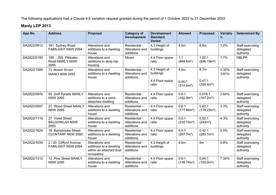
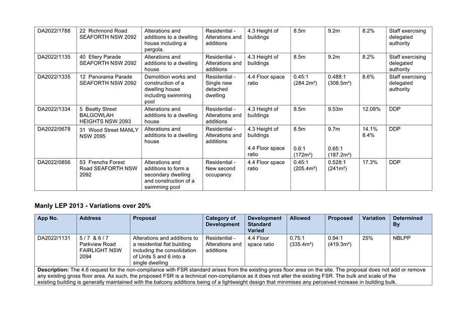
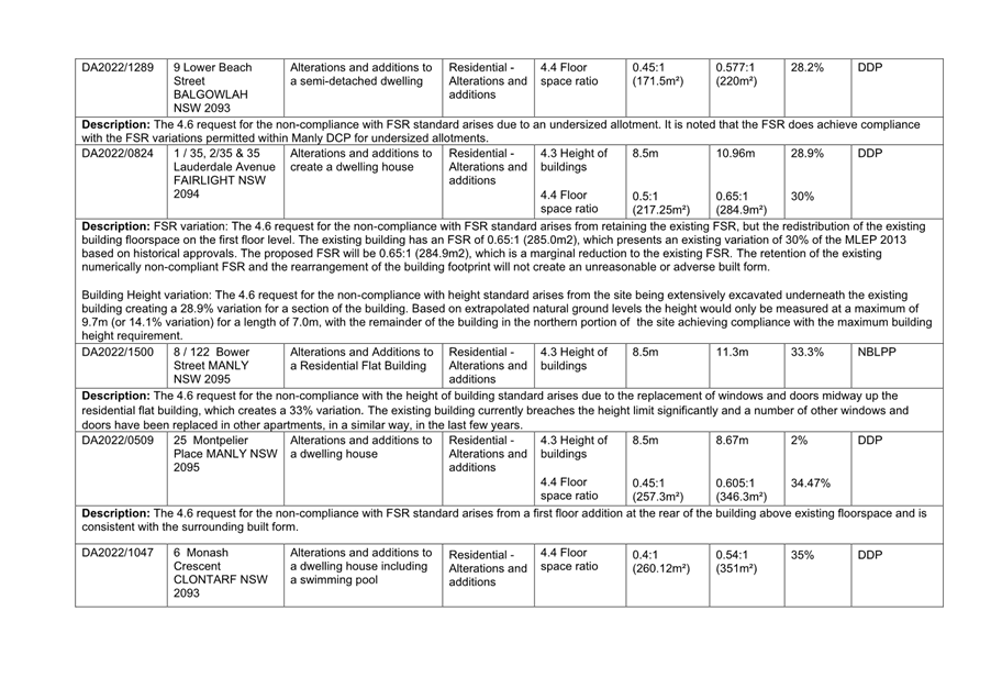
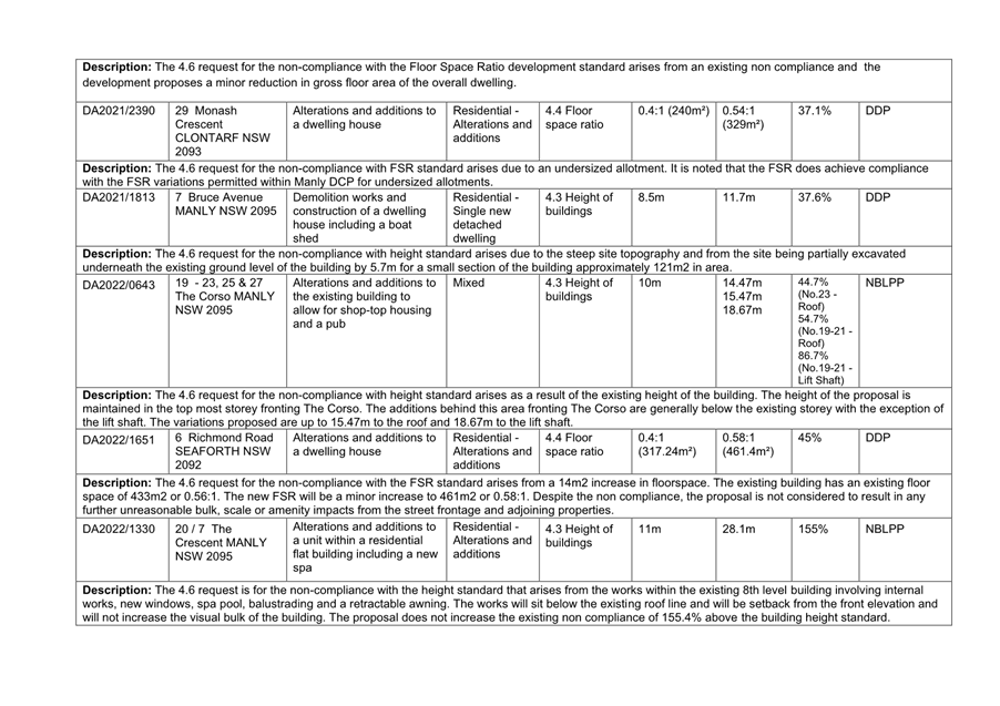
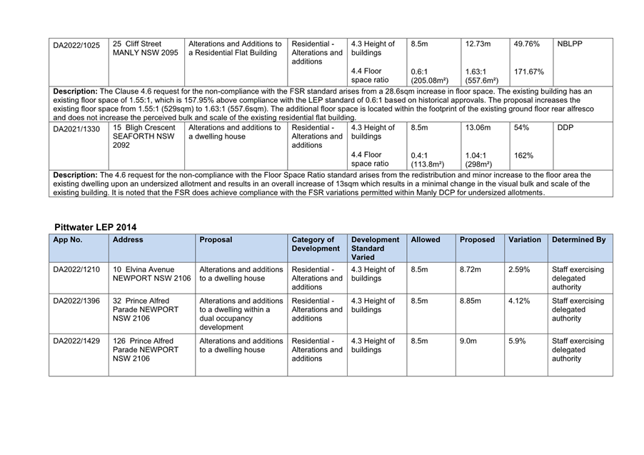
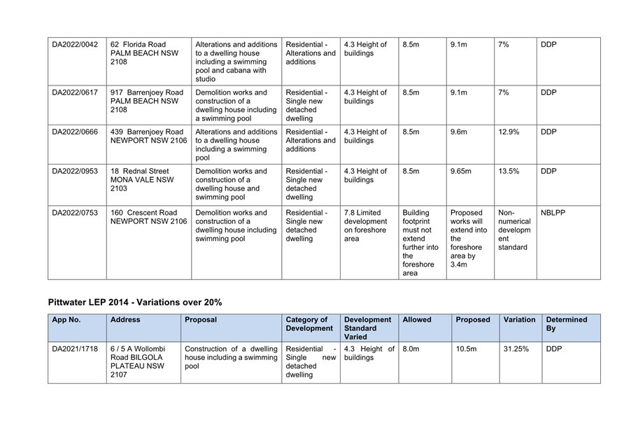
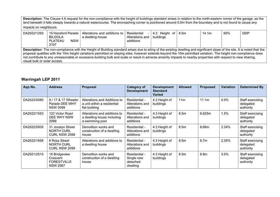
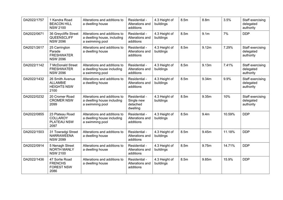
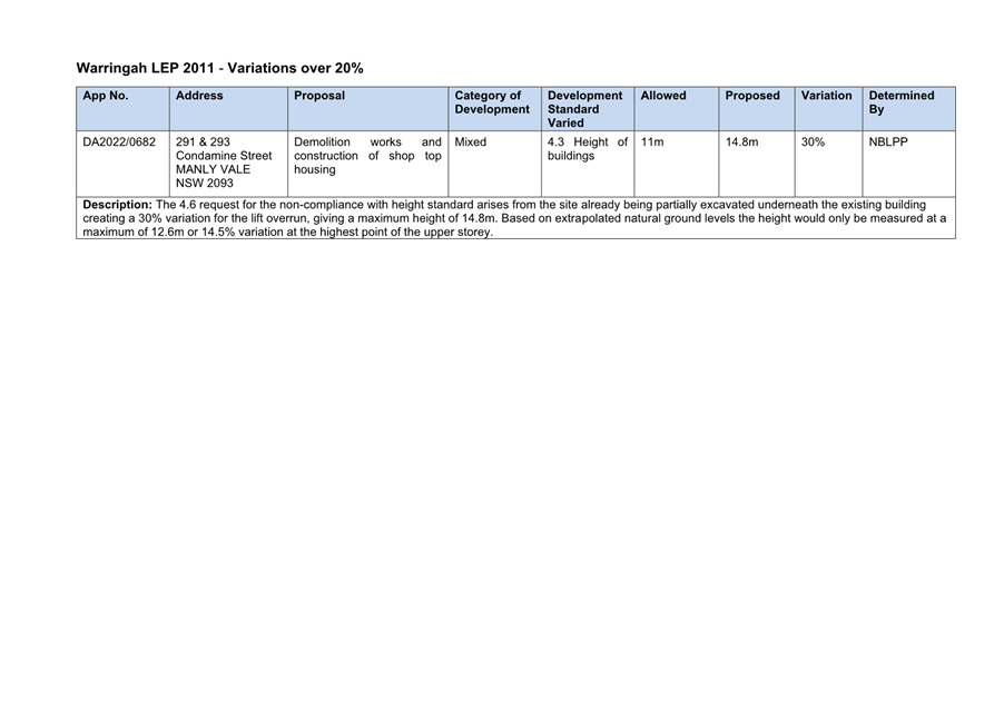
|
|
Report To Ordinary Council MEETING
|
|
ITEM NO. 13.1 - 28 March 2023
|
13.0 Transport and Assets Division
Reports
|
ITEM 13.1
|
Response
to Notice of Motion No 36/2022 - Potholes on Local Roads
|
|
REPORTING
MANAGER
|
Executive
Manager Transport & Civil Infrastructure
|
|
TRIM
file REF
|
2023/141362
|
|
ATTACHMENTS
|
Nil
|
NOTE: This item was listed on the agenda but not dealt with at the 28
February 2023 Council Meeting
purpose
To provide a response to Council’s
Notice of Motion No 36/2022 - Potholes on Local Roads adopted at its ordinary
Council meeting on 22 November 2022.
REPORT
At its ordinary meeting on 22 November 2022
Council resolved (377/22):
That:
1. The Chief
Executive Officer report back to Council’s February 2023 meeting on the
current number of potholes on local roads and number of local roads whose
overall surfaces have been badly damaged by rain this year, with an estimate of
how much it would cost to repair current individual potholes, and to resurface
roads whose overall surfaces have deteriorated due to rain.
2. The Chief
Executive Officer report on how much funding has been spent on (a) fixing
potholes and (b) resurfacing roads this financial year and how much remains in
the budget to fix current and future potholes and road surfaces.
3. Staff
identify and report back to Council’s February 2023 meeting on funding
included in this year’s budget from current capital works projects that
have failed to find suitable tenders that could be used to fix potholes and
resurfacing roads badly damaged by this year’s rain.
4. If no such
funding is available, identify money from other projects not impacted by this
year’s weather that could be spent on road repairs and resurfacing.
5. Council
lobby the NSW government to provide more funding for fixing potholes on local
roads and resurfacing local roads badly damaged by this year’s
rain.
6. Council
calls on the NSW Government to promptly repair state roads in the Northern
Beaches Local Government Area.
In response to Item 1:
Between July 2022 and January 2023:
· Council has repaired 3,346 potholes in the above period
· 1,114 individual local roads have been identified where pavements
have been damaged as a result of the recent periods of wet weather
· $1.9 million has been spent on pothole repairs and road patching,
with some $3 million additional heavy patching programmed for the remainder of
this year and around $7 million proposed for next financial year (some from
normal allocations and around $6 million from the recent State Government Grant
for Local and Regional Road repairs)
· $25-30 million is the estimated cost to fully resurface roads whose surfaces have deteriorated due to rain.
In response to Item 2:
Council has spent the following amounts this
financial year:
(A)
As noted above $1.9 million on fixing potholes and on heavy patches so far this year with around
$3 million currently in hand and being scoped as a result of a State Government
grant
(B)
$5.5 million completed or currently in progress on resurfacing roads this
financial year (to January 2023).
There remains approximately $2.6 million from the $8.1 million Road Re-sheeting
Capital Works budget to complete the current program of works. These works have
been scoped and are in the process of having contractors engaged to deliver the
works program.
In response to Item 3 and 4:
Council is committed to the delivery of the
current adopted capital works program. Should our procurement processes fail to
find suitable tenders on the first occasion, the procurement strategy is
reviewed and addressed depending on the individual situation. It is considered
that there are no capital works projects in the current program, where funding
should be diverted to repairing potholes and resurfacing roads at this
time. It is noted that much of our capital works program funding is
either tied to grant funding, restricted funds (e.g., s7.11 & s7.12 funds),
or required to meet other asset renewal ratios.
The recent State Government announcement of
$500 million for Councils to repair Regional and Local Roads would be best
suited funding the road pavement repairs. Council has been advised that the
allocation to Northern Beaches Council is $9.1 million and works will need to
be completed by February 2024. Actions have already commenced to undertake
these works.
In response to Item 5 & 6:
Council has written
to the Hon. Natalie Ward, MLC, Minister for Metropolitan Roads and Minister
for Women’s Safety and the Prevention of Domestic and Sexual Violence
welcoming funding of the $500 million Regional and Local Roads Repair Program
and requesting further action on the State Road network in the Northern Beaches
Local Government area.
The funding boost to
improve our Local and Regional Road network is welcomed and Council has
requested consideration be given to a general increase in road funding to keep
our road network safe, efficient, and reliable now and into the future.
LINK TO COUNCIL STRATEGY
This report relates to the Community
Strategic Plan Outcome of:
Transport, technology and connectivity -
Goal 17 Our community can safely and efficiently travel within and beyond the
Northern Beaches
FINANCIAL CONSIDERATIONS
The recommendations of this report pose no
financial impact on Council.
ENVIRONMENTAL CONSIDERATIONS
There are no environmental impacts
associated with the recommendations of this report.
Social considerations
There are no social considerations
associated with the recommendations of this report.
governance and risk
considerations
There are no risk or governance issues
associated with the recommendation of this report.
RECOMMENDATION OF Director Transport and Assets
That Council note the information provided in this report.
|
|
Report To Ordinary Council MEETING
|
|
ITEM NO. 13.2 - 28 March 2023
|
|
ITEM 13.2
|
Proposed
Easement to Drain Water Over Fox Reserve, Collaroy to Benefit 41 and 43 Beach
Road, Collaroy
|
|
REPORTING MANAGER
|
Executive
Manager Property
|
|
TRIM file
REF
|
2023/008031
|
|
ATTACHMENTS
|
1 ⇨Easement Dimension Plan (Included In Attachments
Booklet)
2 ⇨Community Engagement Report - Proposed Easement
over Fox Reserve, Collaroy (Included In Attachments Booklet)
|
purpose
To consider a request for an easement to drain water through
a Council reserve (Fox Reserve, Collaroy) (which is Council-owned Community
Land) by the adjacent property owners for the installation of an underground
stormwater drainage pipe for connection to Council’s underground
stormwater drainage pit within Council’s reserve.
executive summary
On 16 September 2020, the Northern Beaches Local Planning
Panel granted development consent to DA2019/1522 for consolidation of 2 lots
into one, demolition works and construction of a dwelling house including a
swimming pool at 41 and 43 Beach Road, Collaroy.
The properties are located on the low side of Beach Road and
under the approved DA are required to adequately deal with the stormwater
overflow generated from the proposed development.
The owners of 41 and 43 Beach Road, Collaroy (Lot 1 DP
300846 and Lot 2 Sec 7 DP 7391) (the applicant) have applied to Council to
obtain an easement to drain water through Fox Reserve, Collaroy (Lot 2 DP
566490) for the installation of an underground stormwater drainage pipe for
connection to Council’s stormwater drainage pit within Fox Reserve.
The applicant will be required to pay Council an amount of
compensation for the proposed easement in accordance with independent qualified
valuation advice received by Council.
Council staff have undertaken internal stakeholder
consultation and external public notification in accordance with section 47 of
the Local Government Act 1993.
During public notification of
the proposed easement, Council received 10 submissions with all 10 submissions
objecting to the proposal. The Local Government Act 1993 provides
that, if a person has made a submission by way of objection to the proposal, a
council must not grant an easement in respect of community land for a period
exceeding 5 years except with the consent of the Minister for Local
Government. Accordingly, should Council wish to grant the easement,
Council will need to apply to the Minister for consent to do so.
Whilst some objections against
the proposal were received, having regard to all relevant circumstances, it is
recommended that Council authorise the grant of the easement and seek the
consent of the Minister to do so.
Council has granted similar
easements previously for underground drainage connections in other Council
reserves where easements do not significantly impact on the use of the reserve.
RECOMMENDATION OF Director Transport and Assets
That Council:
1. Note
that it has considered all submissions in respect of the proposed easement
referred to in Item 3 below (proposed easement) and endorse the position in
relation to the objections received as set out in the report for this item.
2. Apply
to the Minister for Local Government in accordance with Section 47 of the Local
Government Act 1993 for consent to grant the proposed easement.
3. Subject
to the consent of the Minister for Local Government, authorise a one-metre-wide
Easement to Drain Water and associated Positive Covenant, by underground pipe
within Lot 2 DP 566490 Fox Reserve, Collaroy in favour of 41 and 43 Beach Road,
Collaroy (Lot 1 DP 300846 and Lot 2 Sec 7 DP 7391) for an amount in accordance
with Council’s adopted Fees and Charges.
4. Require
the applicant to fund all costs associated with the granting of the proposed
easement and associated Positive Covenant as referred to in Item 3 of this
recommendation, including but not limited to, Council’s legal costs, GST
if applicable, document registration and reinstatement of land post authorised
drainage work.
5. Delegate
authority to the Chief Executive Officer to execute the necessary documentation
to give effect to this resolution.
BACKGROUND
On 16 September 2020, the Northern Beaches Local Planning
Panel granted development consent to DA2019/1522 for consolidation of two lots
into one, demolition works and construction of a dwelling house including a
swimming pool. Condition 9 of Development Consent DA2019/1522 required that the
site to be drained to a new on-site drainage system with a discharge point at
the south-east corner of the site via a level spreader directly to the public
reserve and provided:
9. Stormwater Disposal from
Low Level Property
The Applicant is to
demonstrate stormwater from the new development within this consent shall be
disposed of to a level spreader system in accordance with Northern Beaches
Council’s Warringah Water Management Policy PL 850 in particular the
Stormwater Drainage from Low Level Properties Technical Specification. The
level spreader system shall be located sufficiently from the rear boundary to
allow for maintenance purposes. Details demonstrating compliance with the
Northern Beaches Council’s Warringah Water Management Policy PL 850 are
to be submitted to the Certifying Authority for approval prior to the issue of
the Construction Certificate.
As the site is located at the end of the overall catchment
it was proposed to discharge stormwater from the site with no time delays (no
on-site stormwater detention).
However, recent weather events (heavy rainfall) exposed some
issues with the above approach, including that the existing swale, located
within the public reserve, does not have enough fall due to sand erosion.
Water within the channel is therefore trapped and builds up against the
neighbouring property boundary wall.
A Stormwater Drainage application was submitted to Council
in March 2022 to propose outfall arrangements. Council’s Development
Engineering team refused the application for the following reason:
The private stormwater drainage
line that is proposed to run through the adjacent Council public reserve and
connect to an existing drainage pit requires the creation a drainage easement.
Therefore, after consultation with Council’s
Development Engineering team, the applicant has submitted an Easement over
Council Land application to obtain an Easement to Drain Water over Fox Reserve,
being the downstream property, for the installation of an underground
stormwater drainage pipe to connect to Council’s stormwater drainage pit.
Council’s Water Management for Development Policy
recommends obtaining a drainage easement over the downstream property to
Council’s drainage infrastructure as an option to deal with stormwater
disposal.
Section 46 (1) (a1) of the Local Government Act 1993
specifically allows for such easements over community land, and Council has
granted similar easements over other Council reserves in the past, including
Fox Reserve. The proposed easement will require that the stormwater drainage
pipe be placed under the surface of the ground, therefore, the drainage pipe
will have minimal impact on the use of the reserve after installation.
The proposed easement is one metre wide and approximately 63
metres in length and a plan is included in Attachment 1 of this report.
If the easement is granted, the applicant will be required
to lodge a Stormwater Drainage application to allow the drainage easement under
Section 68 of the Local Government Act 1993. Assessment of the drainage
works under Part 4 of the Environment Planning & Assessment Act 1979
may also be required. The appointed Principal Certifier will assess the Pre-DA
conditions and may require an amendment before issuing an Occupation
Certificate.
Rectification of the Council reserve following installation
of the proposed stormwater drainage pipe will be done by the applicant. The
applicant will be required to submit an appropriate bond, prior to the
commencement of construction, for works within the Council reserve. Ongoing
maintenance obligations for the underground pipe by the owners of 41 and 43
Beach Road, Collaroy, will be registered in a Positive Covenant over 41 and 43
Beach Road, Collaroy, as a condition of granting the proposed easement.
CONSULTATION
The application for easement over Council land was publicly
notified for a period greater than 28 days in accordance with Section 47 of the
Local Government Act 1993, which included a notice on Council’s
website, notice letters to surrounding property owners and notice sign at Fox
Reserve seeking public submissions. The submission period commenced on 4
November 2022 and concluded on 4 December 2022.
As a result of the public notification process, 10 objections
to the proposed easement were received during the notification period. The
objections were opposed to the granting of the proposed drainage easement due
to, among other things, impact on public land and the environment.
In accordance with Section 47 (5) of the Local Government
Act 1993, if an objection is received and Council wishes for the easement
to proceed, Council is required to apply to the Minister for Local Government
for consent to grant the proposed easement. The objections received and Council
officers’ responses are noted below.
|
Theme
|
Issues, change requests
and other considerations raised
|
Council’s
response
|
|
Loss of public land
|
This land is for the
public and should not be just for the benefit of an individual
|
An easement is a common
legal agreement between Council and adjacent property owners to allow for the
connection of services from a neighbouring property to services that run
through Council land such as stormwater, sewer, and water mains. The proposed
easement would only confer rights for the property owner to connect
underground services and does not provide for exclusive use of or access to
Fox Reserve.
|
|
Environmental Impact
|
There is concern about the
environmental impact from the creation of this easement such as sand erosion
and flooding occurring in the Collaroy area.
|
The proposed easement is
to connect private stormwater into an existing stormwater pipe. The
additional amount of water being discharged into the existing pipe will not
be materially increased and therefore will not materially increase the
existing stormwater discharge into Fisherman’s Beach. The connection to
a formal stormwater system will improve overland flow running from the
property across Fox Reserve.
|
|
Theme
|
Issues, change requests
and other considerations raised
|
Council’s
response
|
|
Trees
|
Concern about the impact
on the nearby Norfolk trees
|
A condition of consent for
the Development Consent (DA2019/1522) is that all trees in the Reserve must
be protected.
Council has assessed the
location of the easement with the location of the surrounding trees. Due to
the distance from the easement pipes, there will be no impact to trees in the
reserve.
|
|
Compensation
|
The one-time compensation
payment is not comparable to the future needs of the reserve for the
community.
|
The applicant is required
to pay compensation to Council based on the impact of the proposed easement
on the current value of the reserve.
The applicant is also
responsible for ongoing maintenance costs related to the stormwater system.
|
|
Alternative means to drain
water
|
There should be other
means for the property to drain water other than through public land
|
The Development Consent
(DA2019/1522) included a condition for stormwater disposal to a level
spreader system.
However, certain weather
events raised some issues with the above approach.
To seek an alternative
solution to drain water, the applicant has proposed a private stormwater
drainage line through Fox Reserve and connection to the existing drainage
pit.
The applicant will be required
to submit a Stormwater Drainage application if the easement is granted.
Assessment of the drainage works under Part 4 of the Environment Planning
& Assessment Act 1979 may also be required.
|
A Community Engagement Report of the submissions received is
included in this report as Attachment 2.
TIMING
Should it be approved, the creation of the easement to drain
water over Fox Reserve, Collaroy is expected to be completed within the next 12
months.
LINK TO STRATEGY
This report relates to the Community Strategic Plan Outcome
of:
· Good
governance - Goal 19 Our Council is transparent and trusted to make decisions
that reflect the values of the community
financial considerations
The recommendations of this report pose no negative
financial impact on Council.
The applicant will be required to pay Council an amount of
compensation for the proposed easement in accordance with independent qualified
valuation advice received by Council. All other
associated costs in relation to the proposed easement will be borne by the
applicant.
social considerations
There will be minimal impact to the Community as the
stormwater drainage pipe will be installed under the surface of the ground.
Other surrounding properties have also been granted
easements over Fox Reserve. Therefore, it is considered reasonable for the
applicant to also be granted an easement in this case.
environmental considerations
The proposed easement itself will have minimal environmental
impact as no actual building works or other development are proposed as part of
this determination. Any works required to install pipes in the easement would
be assessed separately in accordance with the Environmental Planning and
Assessment Act 1979
In any case, rectification of Fox Reserve after construction
and ongoing maintenance of the proposed underground drainage pipe will be
undertaken by the owners of 41 and 43 Beach Road, Collaroy.
In relation to the submission about the impact on trees,
Council has assessed the location of the proposed easement with the location of
the surrounding trees and concluded that there will be no impact to trees in
the reserve. Importantly, a condition of Development Consent DA2019/1522 is
that all trees in the reserve must be protected.
The additional amount of water being discharged in the
existing pipe will not materially increase. The connection to a formal
stormwater system will improve overland flow currently running from the
property across Fox Reserve.
As 41 and 43 Beach Road are considered low level properties,
this proposed easement where the water is drained by gravity was recommended as
the most suitable option. Other options such as pumping out the water to
connect to the Council drainage system on Beach Road were not recommended due
to the potential for mechanical and system failures.
governance and risk
considerations
If the proposed easement is not granted, the applicant may
seek an order for the proposed easement from the Supreme Court under section
88K of the Conveyancing Act 1919.
|

|
Report To Ordinary Council MEETING
|
|
ITEM NO. 13.3 - 28 March 2023
|
|
ITEM 13.3
|
Public
Exhibition of a Proposal for a New Community Garden at Annam Road Reserve,
Bayview
|
|
REPORTING
MANAGER
|
Manager,
Park Assets - Planning Design & Delivery
|
|
TRIM
file REF
|
2022/625208
|
|
ATTACHMENTS
|
1 ⇨Proposed Community Garden - Annam Road Reserve
Bayview - Aerial View (Included In Attachments Booklet)
2 ⇨Draft Review of Environmental Factors - Proposed
Community Garden, Annam Reserve at Bayview (Included In Attachments Booklet)
|
purpose
To seek Council’s approval to publicly exhibit a
proposal for a new community garden at Annam Road Reserve, Bayview.
executive summary
An application has
been received from a group of residents to establish a community garden at
Annam Road Reserve, Bayview (Attachment 1). This garden group is intending to
grow organic produce, flowering plants, promote sustainable lifestyles and
provide a neighbourhood meeting place. The garden group has included a concept
plan in its application for a garden of approximately 450m² in size
(included in Attachment 2). The garden group’s objectives are for the
garden to be:
· A happy, enjoyable meeting place for the local community
· A place where shared ideas of organic food growing, food preparation
and eating become the norm and where education, peer learning and sustainable
use of land as a valuable food resource are shared with the local community.
Annam Road Reserve is Council land, located
in a residential area, bordered by Bayview Golf Course to the south-west, low
density residential homes to the north-west and south-east and opposite a
retirement village. The reserve is approximately 4,220m2 in size
with established trees around its perimeter and is not intensively used and
doesn’t have any park infrastructure.
This community garden proposal has been
assessed internally and it has been determined that the proposal aligns with
Council’s Community Gardens Policy and Guidelines (2020). A draft Review of Environmental Factors (draft REF) has been
developed for the proposed community garden (Attachment 2). The draft REF
indicates that the potential impacts are minor or negligible with the
mitigation measures proposed. The proposal is now required to be publicly
exhibited for community feedback.
RECOMMENDATION OF Director Transport and Assets
That:
1. Council
place the proposal for a new community garden at Annam Road Reserve, Bayview on
public exhibition for a minimum of 28 days.
2. The outcomes of the
public exhibition be reported back to Council.
BACKGROUND
An application
has been received from a group of residents to establish a community garden at
Annam Road Reserve, Bayview (the community garden proposal, see Attachment 1).
The garden group is intending to: grow organic produce (fruit and vegetables)
and flowering plants; promote sustainable lifestyles; provide a neighbourhood
meeting place and opportunities for social interaction; and promote physical
activity. The garden group has included a concept plan in its application for a
garden of approximately 450m² in size (included in Attachment 2).
This community garden proposal has been
assessed in accordance with Council’s Community Gardens Policy and
Guidelines (2020). This policy supports a community led approach for the
development of new community gardens.
There are 6 community gardens on
Council-owned or managed land at: Balgowlah, Seaforth, Freshwater, Curl Curl,
Manly Vale and Newport. This is considered low relative to some other local
government areas in Sydney. The nearest community garden to Annam Road Reserve
is at Newport, approximately 4.6km by road.
Annam Road Reserve (the Reserve) is
community land located in a residential area, bordered by Bayview Golf Course
to the south-west, low density residential homes to the north-west and
south-east and opposite a retirement village. The Reserve is approximately
4,220m2 in size with established trees around its perimeter and is
not intensively used and has no park infrastructure.
Comments on the community garden proposal
have been sought from these internal teams: Parks and Recreation; Environment
and Climate Change; Development Assessment; and Transport and Civil
Infrastructure. There was no objection to the proposal proceeding to
public exhibition. Comments received were considered
for the draft Review of Environmental Factors prepared for this proposal (draft
REF, Attachment 2). Some of the matters raised and responses are outlined
below:
· Possible impacts on neighbouring residents - the proposed community
garden may impact on adjoining residents due to noise from garden activities. A
minimum 15m buffer is proposed between homes on the boundary and the community
garden (Attachment 1). It is planned to limit garden activities to 7am to 8pm
or dusk.
· Flora and fauna - according to the available data the reserve does
not contain threatened native vegetation communities.
· The reserve is within the Koala SEPP, 2021 area - threatened fauna
species associated with the adjoining bushland and golf course may visit the
reserve. Possible fauna in the area includes long-nosed bandicoots, blue tongue
lizards and water dragons. To mitigate impacts on flora and fauna, the proposed
garden would be located on the turf area away from the canopy trees.
· Vehicle access to the reserve - an embankment runs across the street
boundary of the reserve. Driveway access should be a matter for future
consideration.
· Access to water - a new tap is proposed to be located close to the
garden.
The community garden proposal is consistent
with the plan of management and land zoning (RE1) applicable to this reserve
and aligns with Council’s Community Gardens Policy and Guidelines (2020).
The draft REF indicates that the potential impacts are minor or negligible with
the mitigation measures proposed (Attachment 2). Council shall publicly exhibit
the proposal and consider submissions before it determines whether to proceed
with the proposal.
CONSULTATION
Should the recommendations within this report be supported,
the community garden proposal would be placed on public exhibition for a
minimum of 28 days, during which community feedback would be sought. The
opportunity to provide feedback would be promoted via: emails to stakeholders;
temporary signs in the reserve; on-site public meeting; letters to nearby
homes; and Council’s social media and a Your Say online webpage. Feedback
would be collected through an online submission form as well as letters and emails.
In accordance with the Community Garden Policy and
Guidelines (2020) initial comments from internal stakeholders have already been
sought and received about the proposal. These stakeholders will be provided a
further opportunity to comment during the public exhibition period.
TIMING
The outcomes of the public exhibition of this community
garden proposal would be reported to a Council meeting following a review of
community feedback received.
Should Council support the establishment of a new community
garden at Annam Road Reserve an agreement between Council and the garden group
would be negotiated and executed. This agreement would define, among other
things, the roles and responsibilities of Council and the garden group for the
development, ongoing maintenance and management of the garden and the final
garden design.
Works to establish the new garden would not commence until a
range of matters are concluded to the satisfaction of Council, including:
approval to establish the garden; the garden agreement; final design and
costings; funding secured.
LINK TO STRATEGY
This report relates to the Community
Strategic Plan Outcome of:
· Protection of the environment - Goal 3 Our community is
well-supported in protecting and enhancing the environment to ensure safe and
sustainable use
· Partnership and participation - Goal 21 Our community is engaged in
decision making processes
· Housing, places and spaces - Goal 12 Our community has access to
spaces that enable healthy and active living and allow for a broad range of
creative, sporting and recreational opportunities to be enjoyed
financial considerations
The cost to publicly exhibit the community garden proposal
can be met from the Parks and Recreation 2022/2023 operational budget.
Like all community gardens the intent is for the community
garden group to meet the costs to establish, maintain and operate the garden
and Council may provide minor financial or in-kind assistance from time to time
such as providing a tap. These financial arrangements will form part of the
agreement between Council and the garden group which must be executed before
the proposed garden can be constructed.
social considerations
Community gardening is a recreational activity that
contributes to the health and well-being of our community as well as providing
a range of environmental, social and educational benefits.
This is a community-led proposal by a group
of residents whose vision includes to create a unique, safe, and
supportive garden for Bayview and the local community. Its objectives include:
· To promote a sense of community where trust, effort, knowledge,
skills, and responsibility are shared, where creativity and the environment are
nurtured, and where philanthropy can flourish.
· To become a happy, enjoyable meeting place for the local community.
A place where shared ideas of organic food growing, food preparation and eating
become the norm and where education, peer learning and sustainable use of land
as a valuable food resource is shared with the local community.
· To work collaboratively with the community, government and
businesses to establish a network to facilitate the establishment and on-going
support of the Bayview Community Garden to make it a successful social activity
for the local community.
Notwithstanding the potential community
benefits of this proposal, the proposal may have impacts on residences located
close to the reserve. Public exhibition of this proposal will provide these
residents and other stakeholders the opportunity to express any concerns and
ideas.
environmental considerations
Should the community garden proposal be
supported by Council, the establishment, maintenance and management of the new
community garden would be done in accordance with all relevant environmental
legislation and regulations and Council policies. The intention is for the
produce to be organic so there is no proposal to use harmful chemicals in the
maintenance of the garden.
Environmental matters raised during the
internal assessment have been considered for the draft REF (Attachment 2). No
trees or vegetation are required to be removed for this proposal.
governance and risk
considerations
This community garden proposal has been
assessed internally and it has been determined that this proposal aligns with
Council’s Community Gardens Policy and Guidelines (2020).
Should Council support the establishment of a new community
garden at Annam Road Reserve an agreement between Council and the garden group
would be negotiated and executed. This agreement would define, among other
things, the roles and responsibilities of Council and the garden group for the
development, ongoing maintenance and management of the garden and the final
garden design.
|
|
Report To Ordinary Council MEETING
|
|
ITEM NO. 13.4 - 28 March 2023
|
|
ITEM 13.4
|
Outcome
of Community Engagement - Market Lane Waste Facility Access Fee
|
|
REPORTING
MANAGER
|
Manager,
Property, Commercial & Tourist Assets
|
|
TRIM
file REF
|
2023/150533
|
|
ATTACHMENTS
|
1 ⇩Community
Engagement Report - Proposed New Fee for Market Lane Waste Facility
|
purpose
To report on the submissions received from
the public exhibition of the proposed Market Lane Waste Facility Fee and to
seek Council endorsement for the proposed access fee.
executive summary
At the Council meeting held on 22 November 2022 Council
resolved to:
1. Place
on public exhibition for a minimum of 28 days, the proposed new fee of $585
(GST inclusive) for access to a commercial bin storage area for Market Lane
businesses located within the Whistler Street carpark.
2. Provide a further report on the outcome of the public exhibition of
the proposed fee.
The proposed fee was publicly notified from 8 December 2022
to 29 January 2023 via Council’s YourSay page, Council’s
E-News and our Have Your Say community engagement newsletter. Two responses
were received, with one being supportive and one unsupportive of Council
charging a fee to access the facility. Further detail on the feedback received
is available in the attached Community Engagement Report.
It is recommended that a new fee for access to the area is
established for a 12-month trial period. It is proposed that this fee is set at
$585 (GST inclusive) per participating business to cover administration and
access to the commercial bin storage area during this trial period.
RECOMMENDATION OF Director Transport and Assets
That:
1. Council
note the community feedback from the public exhibition of the draft Market Lane
Waste Facility Access Fee.
2. Council
approve the new proposed Market Lane Waste Facility Access Fee.
BACKGROUND
Council
has been working with the Manly Business Chamber on a proposed waste storage
area in the Market Lane precinct to find a solution to the issue with
businesses leaving their commercial bins outside their premises.
The
proposed area to be used by the Market Lane precinct businesses is an existing
Council bin storage area located in Whistler Street carpark.
To provide an affordable, efficient, scalable, and
sustainable model for the businesses to access the commercial bin storage area,
a new fee for access to the area has been proposed for a 12-month trial period.
It is proposed that this fee is set at $585 (GST inclusive) per participating
business to cover administration and access to the commercial bin storage area
during this trial period. It is not intended that Council will have any
operational involvement with the waste removal from this storage. A business
representative appointed by the Manly Business Chamber shall arrange a
centralised waste contract for businesses with Council-issued access agreements
in place.
This fee was not exhibited as part of the 2022/23 Fees and
Charges as the commercial bin storage area location had not been decided at
that time.
Council resolved to place the proposed fee on public
exhibition at its November 2022 meeting and subsequent to that meeting carried
out Public Notification between 8 December 2022 to 29 January 2023.
CONSULTATION
The working group, in identifying an appropriate location
for the Market Lane waste facility, consulted with relevant business units
within Council to determine the process and fee for location and access of the
facility, including the Property Team, Transport Network Team, Community
Transport, Parking and Fleet and Waste Management and Cleansing. The Manly
Business Chamber has been kept informed as the working group considered
appropriate options for the location of the proposed commercial
bin facility and supports the location in Whistler Street carpark.
The proposed fee was publicly notified from 8 December 2022
to 29 January 2023 via Council’s YourSay page, Council’s
E-News and our Have Your Say community engagement newsletter. Two responses
were received, with one being supportive and one unsupportive of Council
charging a fee to access the facility.
The response that was not supportive of the
proposal felt it was unnecessary to charge local business for access to the
facility. In response to this submission Council staff have advised that
private use of public land is something for which Council does charge a fee.
Food and Beverage premises generally have a condition of their development
consent to set aside an adequate area for waste storage within their own
premises. It would not be a sustainable or equitable approach to allow
businesses to store their waste bins for free on public land.
The attached Community Engagement report
provides a verbatim record of the submissions along with further information as
to why a fee is appropriate in the given circumstances.
TIMING
Should Council approve the proposed fee, it is anticipated
the facility will be operational during Q2 of 2023.
LINK TO STRATEGY
This report relates to the Community
Strategic Plan Outcome of:
· Environmental sustainability - Goal 6 Our Council is recognised as a
leader in environmental sustainability
· Good governance - Goal 20 Our Council is proactive, and efficiently
and effectively responds to, and delivers on, the evolving needs of the
community
· Partnership and participation - Goal 22 Our Council builds and
maintains strong partnerships and advocates effectively on behalf of the
community
financial considerations
It is anticipated that introduction of the fee for access to
this new facility will generate approximately $5,000 in unbudgeted operational
revenue for Council over the proposed 12-month trial period.
|
Fee
|
Unit
|
$
|
GST Applicable
|
|
Market Lane Waste Facility Access fee
|
Per business
|
$585
|
Yes (included in fee)
|
social considerations
Introducing this fee will ensure that businesses located
within the Market Lane precinct have a reasonable opportunity to take part in
accessing the Market Lane waste facility at Whistler Street carpark,
alleviating the issues of unsightly commercial bins being left in public areas.
It is anticipated that the removal of commercial bins from
the Market Lane precinct area will have a positive social impact on the local
community who use that area for recreation and socialising.
environmental considerations
The Market Lane waste facility area will be used by a number
of businesses located in the Market Lane precinct with day-to-day
operations and management undertaken by a nominated Market Lane business user, ensuring
the facility is kept in a clean and tidy condition and regular servicing of the
commercial bins undertaken.
governance and risk
considerations
Each business will enter into an agreement with Council for
access to the Market Lane waste facility area and be issued with swipe cards to
access the facility. The facility will operate for a 12-month trial period
after which time ongoing access will be reviewed by Council in collaboration
with businesses using the facility and the Manly Business Chamber.
|

|
Attachment 1
Community Engagement Report - Proposed New Fee for
Market Lane Waste Facility
|
|
ITEM NO. 13.4 - 28
March 2023
|
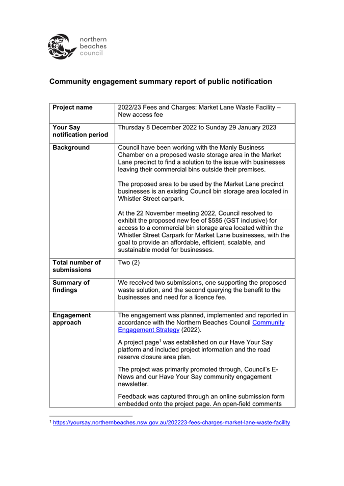

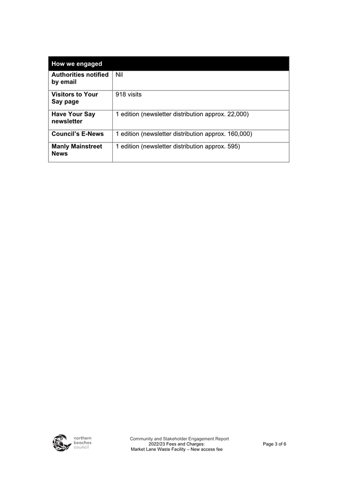
|
|
Report To Ordinary Council MEETING
|
|
ITEM NO. 15.1 - 28 March 2023
|
15.0 Notices of Motion
|
ITEM 15.1
|
Notice
of Motion No 1/2023 - Parking Restrictions Request, Pittwater Road, Collaroy
|
|
TRIM
file REF
|
2023/141372
|
|
ATTACHMENTS
|
Nil
|
Submitted by:
Councillor Vincent De Luca OAM
NOTE: This item was listed on the agenda but not dealt with at the 28
February 2023 Council Meeting
That Council formally write to the NSW
Minister for Roads and the Shadow Minister for Roads requesting the
implementation of hourly parking restrictions on Pittwater Road from the
intersection of Anzac Parade and Pittwater Road to Hadleigh Avenue, Collaroy to
prevent cars for sale taking up much needed resident and beach-user parking and
posing safety risks with potential purchasers walking on Pittwater Road to
inspect vehicles.
|
|
Report To Ordinary Council MEETING
|
|
ITEM NO. 15.2 - 28 March 2023
|
|
ITEM 15.2
|
Notice
of Motion No 2/2023 - Beach Safety Signs
|
|
TRIM
file REF
|
2023/141415
|
|
ATTACHMENTS
|
Nil
|
Submitted by:
Councillor Michael Gencher, Councillor Rory Amon
NOTE: This item was listed on the agenda but not dealt with at the 28
February 2023 Council Meeting
That:
1. In
an ongoing effort to reduce the drowning toll, Council work with local Surf
Life Saving Clubs, Surf Life Saving Northern Beaches, and Surf Life Saving
(SLS) NSW to identify, investigate and participate in available innovative
projects and programs that specifically target high risk locations/user groups
and to further improve public awareness.
2. Council
consider the installation of improved, prominent beach safety signs as
permanent installations at beach entrances, and in the general proximity of
coastal areas – to complement the temporary warning signage, services and
information currently provided by local Surf Life Saving Clubs and coastal
lifeguard services.
3. Council
consider the installation of improved permanent and prominent beach safety
signage at identified blackspot locations throughout the Northern Beaches. A
blackspot location is one that, historically, has had a high number of coastal
safety-related incidents including preventions, rescues, emergency call outs
and drownings – or being an unpatrolled beach – or area of beach.
4. Council
consider the production and installation of permanent and prominent beach
safety signage and translations of key beach safety messages in multiple
languages - as is currently standard practice for several Councils.
5. An
agreed action plan be prepared, and Council briefed by July 2023 – with
the above actions to be funded from relevant operational budgets (if adopted),
and if adopted, to be ready for implementation by September 2023 – to
coincide with the start of summer and the SLS Patrol Season.
BACKGROUND FROM
COUNCILLOR Michael
Gencher AND COUNCILLOR RORY AMON
As at the writing of this background – Thursday 9
February 2023, there have been 56 drowning deaths in Coastal and Inland
Waterways in NSW this summer. Beach safety signs are designed to send clear
messages and warnings.
Surf Life Saving (SLS) NSW has indicated that coastal
drownings are up 30 per cent on the 10-year average – with a 13 per cent
increase on last year.
This summer the drowning toll is the highest on record –
including several tragic drownings on our Northern Beaches.
According to the National Coastal Safety Report 2022, 939
coastal drowning fatalities were recorded from 2012-2022, almost half of which
were overseas-born beachgoers. However, the 939 fatalities were only of people
whose birth continent was known, so the total number of drownings is higher.
Current research indicates that 50 per cent of beach goers
born overseas and approximately 40 per cent of locals rarely see, or never read
beach safety signage at beaches they are not familiar with.
Approximately half of the overseas-born beachgoers had no
understanding of some beach safety terms such as, rip, bank, high surf, shore
dump, or bluebottles.
Not seeing, not reading, and not understanding the signs,
could, and does have deadly consequences.
Research indicates that many people are also unsure about what
the Australian beach flags mean - while they represent ‘always swim
between the flags’, more than 30 per cent of the overseas visitors and
residents believe that beach flags mean that only people ‘perceived to be
good swimmers’ were allowed to be between the flags.
Another common flag instruction – ‘No flags = no
swim’ – is also confusing, with research showing that this instruction
is perceived as – ‘they may not swim, but they may play, walk, and
stand/wade in the water’.
Currently, local Surf Life Saving Clubs are having to deal
with an overwhelming number of preventions and rescues, due to the lack of
signage and information. The local surf clubs are having to hire (at their own
expense) variable message sign (VMS) boards with safety and information
messaging to protect beachgoers.
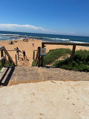
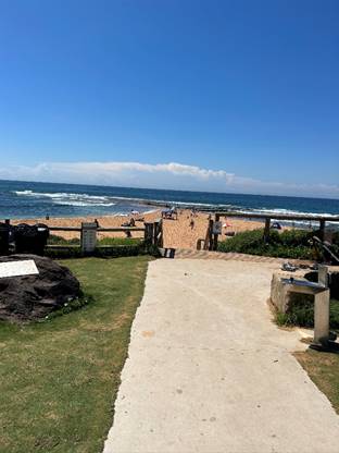
|
|
Report To Ordinary Council MEETING
|
|
ITEM NO. 15.3 - 28 March 2023
|
|
ITEM 15.3
|
Notice
of Motion No 3/2023 - Cashless Gaming Card Reform
|
|
TRIM
file REF
|
2023/141477
|
|
ATTACHMENTS
|
Nil
|
Submitted by:
Councillor Rory Amon
NOTE: This item was listed on the agenda but not dealt with at the 28
February 2023 Council Meeting
That Council
1. Support, in principle, the NSW Government-announced cashless gaming
card policy.
2. Write to the NSW Premier and the Leader of the Opposition informing
each of Council’s position.
BACKGROUND FROM
COUNCILLOR Rory
Amon
Problem gambling is a scourge on society.
Council can play a role in advocating for reform in this space. In 2017, this
council resolved in favour of calling on the NSW Government to put an immediate
cap on poker machine licences in the Northern Beaches LGA.
The NSW Government has announced a policy
to make every poker machine cashless by 31 December 2028. This will help combat
and reduce problem gambling and money laundering. Full details of the policy
can be read on here (https://www.nsw.gov.au/media-releases/pokies-to-be-cashless-2028-under-historic-changes#:~:text=The%20NSW%20Liberal%20and%20Nationals,laundering%20in%20electronic%20gaming%20machines) .
The policy announcement has been widely
supported, including by the Alliance
for Gambling Reform and Independent Members of Parliament, Alex Greenwich and
Greg Piper (see here -
https://www.smh.com.au/national/nsw/perrottet-on-a-winner-as-advocates-and-mps-praise-pokies-reform-20230206-p5cicb.html).
|
|
Report To Ordinary Council MEETING
|
|
ITEM NO. 15.4 - 28 March 2023
|
|
ITEM 15.4
|
Notice
of Motion No 6/2023 - Brewarrina Sister City Youth Program
|
|
TRIM
file REF
|
2023/141494
|
|
ATTACHMENTS
|
Nil
|
Submitted by:
Councillor Sue Heins and Councillor Ruth Robins
NOTE: This item was listed on the agenda but not dealt with at the 28
February 2023 Council Meeting
That Council:
1. Investigate
future options of supporting our Sister City relationship with Brewarrina in
supporting youth from both Brewarrina and the Northern Beaches LGA.
2. Staff
prepare a report to come back within 3 months outlining future possible options
to continue this support, including the financial cost for consideration in the
2023/24 Budget.
BACKGROUND FROM
COUNCILLOR Sue
Heins AND COUNCILLOR RUTH ROBINS
Since COVID-19 our relationship with
assisting the youth of our sister city, Brewarrina and sending our youth to
Brewarrina appears to have halted.
Historically the Bush to Beach program
supported primary-aged children and Brewarrina Council had a system that brought
high school achievers to the Northern Beaches and Northern Beaches Council sent
local high school achievers to Brewarrina and surrounds.
Bush to Beach has a vision to connect
outback regional areas in need with local surf lifesaving clubs as is the
relationship with South Narrabeen SLSC and Brewarrina.
There appears to be an opportunity to
re-engage and for Councillors to assess which way forward in assisting to
re-engage for the benefit of our youth and assist their development.
|
|
Report To Ordinary Council MEETING
|
|
ITEM NO. 15.5 - 28 March 2023
|
|
ITEM 15.5
|
Notice
of Motion No 7/2023 - Urgent Request for a Safety Audit of Electric Bike,
Electric Scooter and Other Bike Usage on Northern Beaches Shared Paths, Bike
Paths and Footpaths
|
|
TRIM
file REF
|
2023/141499
|
|
ATTACHMENTS
|
Nil
|
Submitted by:
Councillor David Walton and Councillor Sprott
NOTE: This item was listed on the agenda but not dealt with at the 28
February 2023 Council Meeting
That:
1. The
Northern Beaches Council Local Traffic Committee, in partnership with the
Northern Beaches Police Area Command, conduct an urgent safety audit of
electric bike, electric scooter and other bike usage, on Northern Beaches
shared paths, bike paths, and footpaths. The safety audit should include
consideration of, but not limited to:
A. Speeding;
B. Shared
path design models and factors;
C. Path
separation versus segregation;
D. Advisory
speed signage;
E. Education
and communication campaign on electric bike, scooter and other bike legislative
responsibilities; and
F. Regulatory
factors, including Council Rangers and Police operations to target
non-compliance of road rules applicable to electric bikes, scooters and other
bikes.
2. The
outcomes of the safety audit be reported back to Council as a matter of
urgency, with recommendations to mitigate the increasing risks associated with
these safety issues.
BACKGROUND FROM
COUNCILLOR David
Walton AND COUNCILLOR SPROTT
The Northern
Beaches shared paths are an area open to the public that is designated for the
use of both bicycle riders and pedestrians. The Northern Beaches is
seeing a significant increase in the use of electric bikes, scooters and other
bikes on shared bike paths with increased speeds, that a reasonable person
would consider an increasing risk to pedestrian safety.
An increasing
number of residents are contacting their elected representatives to address
this increasing safety concern.
When riding on
a shared path, the road rules require electric bicycle riders and other bike
and scooter riders to:
· Keep to the left (unless it is impractical to do so)
· Give way to pedestrians including wheeled recreational devices/toys.
You should always slow down, stopping if necessary to avoid a collision.
· Keep to the left of any oncoming bicycle rider.
In line with
the Centre for Road Safety guidance, to make paths safer for everyone it is
recommended that bike riders:
· Provide pedestrians with a metre of space when passing
· Use their bell to warn others when you are approaching
· If there is room, moving off the path to the left if you wish to
stop riding
· Be careful around young children and dogs, as they are often unpredictable
in their movements, and older pedestrians who may be more vulnerable
· Travel at a safe speed so you can stop within a safe distance of
pedestrians on the path.
|

|
Report To Ordinary Council MEETING
|
|
ITEM NO. 15.6 - 28 March 2023
|
|
ITEM 15.6
|
Notice
of Motion No 4/2023 - Duffys Forest Community Bridle Trail
|
|
TRIM
file REF
|
2023/141507
|
|
ATTACHMENTS
|
1 ⇩Rob
Stokes MP Letter of Support to Council - Duffys Forest and Terrey Hills
Community Bridle Trail
2 ⇩NBCS
Letter of Support to Council - Duffys Forest and Terrey Hills Community
Bridle Trail
|
Submitted by:
Councillor Rory Amon
NOTE: This item was listed on the agenda but not dealt with at the 28
February 2023 Council Meeting
That:
1. In consultation with the Duffys Forest Residents Association and
Terrey Hills Progress Association, Council Officers prepare a draft
“Community Bridle Trail Action Plan” detailing the steps which need
to be taken in the short, medium and long term, to repair and enhance the Community
Bridle Trail.
2. A report be brought back to Council in 3 months providing a draft
Action Plan and next steps for Council’s consideration.
BACKGROUND FROM
COUNCILLOR Rory
Amon
The Community Bridle Trail through Terrey
Hills and Duffys Forest is a unique feature of this wonderful area. For those
not familiar, the Community Bridle Trail can be described as a naturally formed
trail through the Terrey Hills and Duffys Forest area which provides amenity
for walkers, runners, bike riders and horse riders.
Unfortunately, over time, the Trail has
degraded and become unsafe for users. The purpose of this motion is to
establish a process by which the Trail can be repaired and enhanced.
On 25 January 2023, the Duffys Forest
Residents Association provided Council with correspondence detailing steps
which needed to be taken in relation to the Bridle Trail. A copy of that
correspondence will be provided to Councillors. It is noted that both the local
Member of Parliament, the Hon. Rob Stokes MP, and Northern Beaches Christian
School support the residents’ efforts on this matter.
|

|
Attachment 1
Stokes - Brownlee - OBO Duffys Forest Residents
Association
|
|
ITEM NO. 15.6 - 28
March 2023
|
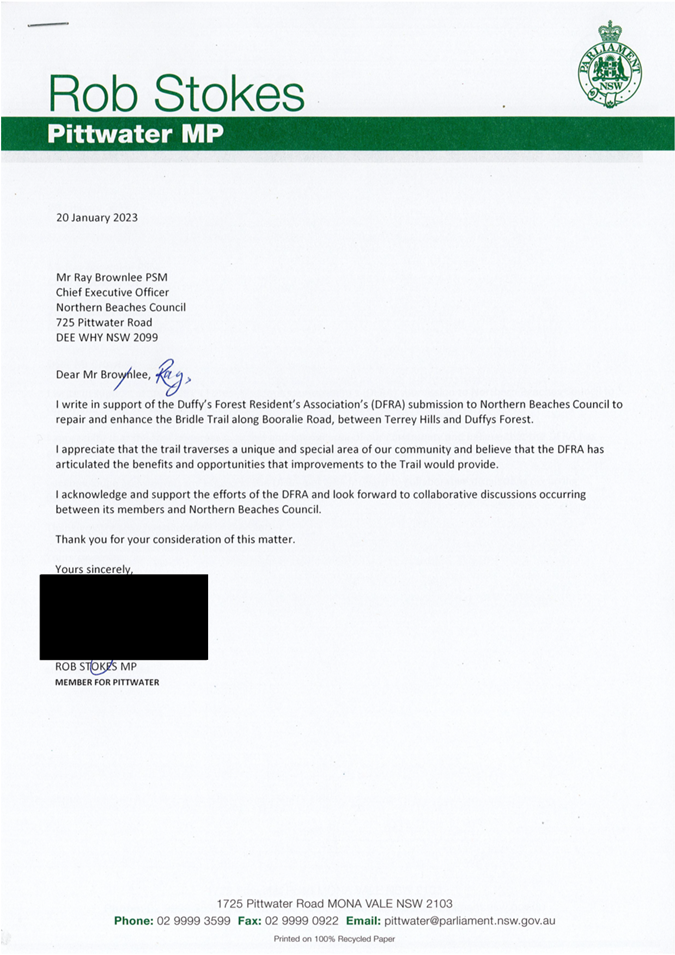
|
|
Attachment 2
NBCS Letter of Support to Council - Duffys Forest and
Terrey Hills Community Bridle Trail
|
|
ITEM NO. 15.6 - 28
March 2023
|
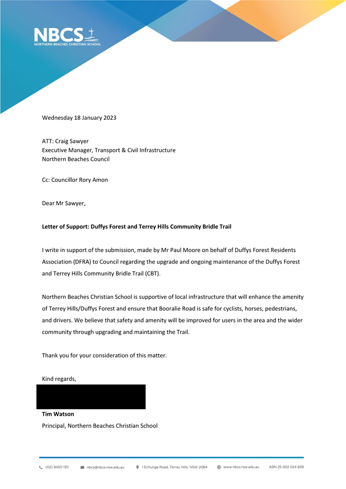
|

|
Report To Ordinary Council MEETING
|
|
ITEM NO. 15.7 - 28 March 2023
|
|
ITEM 15.7
|
Notice
of Motion No 5/2023 - Daydream Street, Warriewood
|
|
TRIM
file REF
|
2023/141515
|
|
ATTACHMENTS
|
Nil
|
Submitted by:
Councillor Rory Amon
NOTE: This item was listed on the agenda but not dealt with at the 28
February 2023 Council Meeting.
That Council write to Transport for NSW
seeking advice as to the detailed reasons why Daydream Street, Warriewood, is
proposed to remain closed onto Mona Vale Road moving forward.
BACKGROUND FROM
COUNCILLOR Rory
Amon
Daydream Street, Warriewood, intersects
with Mona Vale Road, but has been closed off.
Residents have been attempting to
understand why the road is proposed to remain closed following the completion
of the Mona Vale Road (East) duplication but have been unable to receive
reasons from the project managers or Transport for NSW (TfNSW) as to the
reasons why the road is proposed to remain closed.
The purpose of this motion is for Council
to write to TfNSW and seek formal advice and reasons for the proposal for
Daydream Street to remain closed.
|
|
Report To Ordinary Council MEETING
|
|
ITEM NO. 15.8 - 28 March 2023
|
|
ITEM 15.8
|
Notice
of Motion No 9/2023 - Building and Development Compliance
|
|
TRIM
file REF
|
2023/180481
|
|
ATTACHMENTS
|
NIL
|
Submitted by:
Councillor Kristyn Glanville
1. Council
note:
A. The
leadership role Council plays in fostering a strong compliance culture within
the community with regards to compliance with building and development
controls.
B. Resourcing
of compliance staff dealing with development and building control, and other
areas of compliance, are being prioritised for review through the ongoing
service levels review being undertaken by Council staff.
C. Council’s
Compliance and Enforcement Policy is being currently reviewed by staff, and
draft amendments for exhibition will be reported to the May 2023 council
meeting.
2. The
Chief Executive Officer prepare a report to Council at the May 2023 meeting
concerning the following points regarding the private certification scheme:
A. Any
issues identified by staff or residents regarding the efficacy of this scheme
B. Any
recommendations for improving state legislation dealing with oversight of
development and compliance
C. Prepare
a draft letter to the NSW Government, Shadow Planning Spokesperson, Department
of Fair Trading, Office of Local Government, and NSW Local Government
Association, highlighting the matters identified in A - B.
3. The
Chief Executive Officer prepare a workshop by May 2023 for the Councillors
concerning any innovative ideas for improving compliance by the community with
building and development regulations. This could include, for example:
A. Proactive
and random inspections of building sites
B. Joint
inspection ‘blitzes’ with co-regulators such as the NSW EPA
C. Use of
new technology to identify illegal development such as clearing of trees
D. Education
campaigns to improve a culture of compliance.
4. The
Chief Executive Officer report back to Council at the May 2023 meeting with
options for resourcing a specialised compliance team responsible for dealing
with allegations of unauthorised tree or vegetation clearing.
BACKGROUND FROM
COUNCILLOR Kristyn
Glanville
1. Council’s
role as a regulator
Council has jurisdiction to take enforcement
and compliance activity in relation to a number of areas, which are listed in
its Compliance and Enforcement Policy. This jurisdiction includes development
and building control, pollution control and environmental degradation or
damage, environmental health, public health and safety, waste water systems,
control over companion animals, food safety, fire safety, tree preservation,
residential swimming pool safety, and noxious weeds. Council has various
powers to investigate and address allegations of breaches, including (but not
limited to) issuing compliance orders and bringing enforcement proceedings.
2. Community
concerns regarding the efficacy of compliance measures
Councillors frequently receive complaints from
residents about non-compliance they have observed in the community in relation
to these areas. Some common complaints concern non-compliant development, tree
lopping or removal without permission, and dogs on beaches where they are not
permitted.
Some specific examples of complaints received
by Councillors regarding non-compliant development include that:
· The development did not first obtain a development approval (DA) or
complying development certificate (CDC), and was otherwise not exempt development.
· The developer/landowner obtained a CDC which ought not to have been
granted by the private certifier, as the development was not in fact complying
development, or which has unreasonable amenity impacts on their privacy, solar
access, view sharing, etc.
· The private certifier has taken a lax approach to oversight of the
development
· Residents are directed by Council to raise their complaints to the
certifier, but the certifier takes no action.
· Complaints by residents to Fair Trading regarding the conduct of a
private certifier do not result in any meaningful action being taken against
that certifier.
· The costs of taking private enforcement action to the Land and
Environment Court are beyond the means of ordinary residents, as this would
realistically cost in the order of $100,000, and there is only a window of 3
months to bring proceedings.
· The resident has identified what they believed to be unauthorised
clearing of trees or vegetation on both private and public land.
3. Rationale
for this motion
There is harm to the community and
environment where breaches are common and take place with impunity.
Illegal development can undermine social cohesion of a neighbourhood, have
negative visual amenity and privacy impacts on residents, undermine ecological
sustainability of development, and have a significant financial cost to
residents in having to bring private enforcement proceedings or having the
value of their property devalued by neighbouring illegal works. Even
relatively “minor” breaches which do not cause environmental harm,
may nonetheless cause social harm due to their everyday impacts on amenity or
by generally reinforcing a lax culture towards compliance within the community.
Recognising that Council has a diverse range
of activities that it regulates, this motion seeks to:
1. Note
for the community’s visibility the forthcoming reviews of resourcing of
enforcement and compliance activity by Council staff, with a view to ensuring
Council is appropriately resourced to deal with the number of complaints being
received and promote a culture of compliance within the community. For
example, compliance staff dealing with building and development issues
currently deal with approximately 80 complaints each at any given time,
however, it is likely that 25-30 complaints would be a more manageable workload
in order to ensure high levels of customer satisfaction, rigour ,and staff
morale and wellbeing.
2. Note
for the community’s visibility an upcoming review of Council’s
existing Compliance and Enforcement Policy. This policy guides the activities
of staff and discretions exercised during investigations.
3. Advocate
on behalf of the community for reforms to the private certification system,
given this scheme generates many of the complaints raised to Council, and much
of the frustration experienced by the community.
|
|
Report To Ordinary Council MEETING
|
|
ITEM NO. 15.9 - 28 March 2023
|
|
ITEM 15.9
|
Notice
of Motion No 10/2023 - Warringah Aquatic Centre Adult Swim Classes
|
|
TRIM
file REF
|
2023/185181
|
|
ATTACHMENTS
|
NIL
|
Submitted by:
Councillor Rory Amon
That:
1. An options report be prepared and presented to the April 2023
Council meeting that outlines options available to Council to re-establish the
Swim Fit squads with a suitable staff member or temporary hire to run the
squads until such time that the Warringah Aquatic Centre can find suitable and
more permanent coaching replacements. The options report is to include
consideration of the following matters:
A. Options available to offer an attractive renumeration in line with
the Local Government (State) Award for a suitably qualified candidate.
B. Options to explore all available avenues, including commercial
organizations, to identify a longer-term coaching solution.
C. Options available for Council to run the squads with other staff
when the regular coach is sick or unavailable
2. Council when conducting future expressions of interest/ tender for
swimming squads with Warringah pool and other pools to include both children
and adult swim squads.
BACKGROUND FROM
COUNCILLOR Rory
Amon
Warringah Aquatic
Centre (WAC) has been running adult squads for decades, providing local
residents adult swim classes every weekday at 9.30am to around lunch time, the
latter for local office workers and the like. This has been an exemplary
service and it provided fitness for predominately 30–80 year-olds over a
very long time. There are numerous people with disabilities both physical and
mental who rely on their swimming fitness for their well-being. There are also
residents in the 80s who love the squads as a part of their fitness and
friendship regime and rely on the service as their only form of exercise each
week.
Not only is it
good for fitness but also does a lot of good for emotional well-being,
networking and social aspects for the community. There is a substantial number
that currently benefit from the squads. No doubt this contributes significant
income to the WAC since it is central to why many people subscribe for the
annual membership or pay on a daily entry basis. A significant amount of income
will be lost should the squads not be re-instated.
The issue the
swimmers now face has arisen since 23 December 2022 when all squad
swimmers were informed that the regular coach was going to take long service
leave and that no swim squads would be available until 23 March 2023. However,
this was followed by a further communication in mid-March saying the squads are
no longer viable and offering a refund on pre-paid annual fees. All information
on adult swim squads has been taken off the Council website.
People
participating in the Warringah Adult Swim Squads believe that the WAC is the
jewel of Northern Beaches and is an excellent facility. People from all over
the Northern Beaches use the squads. It is therefore difficult for the users to
reconcile that the WAC – which has long been the home of one of the best
adult swim squads – can now no longer offer this service. The users are
also understandably upset by how abruptly the service was withdrawn.
The swimmers are
grateful for a constructive meeting with the Executive Manager, Recreation
Services on 17 March 2023, and they appreciate staff efforts and willingness to
work with the group going forward.
Staff have
confirmed that they have written to squad swimmers to advise that as an interim
measure, from 22 March 2023, 4 lanes will be set aside for lap swimmers from
9.30am to 10.30am and that each of the lanes will have a sign designating it as
slow, medium or fast.
|
|
Report To Ordinary Council MEETING
|
|
ITEM NO. 16.1 - 28 March 2023
|
16.0 Questions with Notice
|
ITEM 16.1
|
Question
With Notice No 5/2023 - Manly's Little Penguins
|
|
TRIM
file REF
|
2023/168460
|
|
ATTACHMENTS
|
NIL
|
Submitted by: Councillor Sarah Grattan
QUESTION
1. What are the most recent
figures of Little Penguin breeding pairs?
2. What are the main causes of
the decline in penguin population numbers over the last 10 years?
3. What measures have been taken
by lead authorities in the last 12 months to protect Manly’s Little
Penguins?
4. What support was provided by
Council?
5. How effective were the
measures instituted to date?
6. What measures and enforcement
must be taken by relevant authorities to protect the remaining
penguins? What can Council do to support?
7. What would be the cost of
increased ranger presence at Collins Beach and other sensitive habitat
sites during the penguin nesting season?
8. What
actions should we ask the lead authorities to take to avoid the extinction of
Little Penguins at Manly (NSW National Parks and Wildlife Service,
Department of Environment)
|
|
Report To Ordinary Council MEETING
|
|
ITEM NO. 16.2 - 28 March 2023
|
|
ITEM 16.2
|
Question
With Notice No 6/2023 - Brookvale Structure Plan - Night Clubs
|
|
TRIM
file REF
|
2023/179077
|
|
ATTACHMENTS
|
NIL
|
Submitted by: Councillor Vincent De Luca
OAM
QUESTION
At the recent Candidates' Forum for State
Candidates, Mayor Michael Regan stated that the Brookvale Structure Plan will
include "Night Clubs". Could this please be confirmed whether this is
accurate and if so where exactly would "Night Clubs" be allowed in
Brookvale?
|
|
Report To Ordinary Council MEETING
|
|
ITEM NO. 16.3 - 28 March 2023
|
|
ITEM 16.3
|
Question
With Notice No 7/2023 - Brookvale Structure Plan - Increased Development and
Lack of Transport Infrastructure to Cope
|
|
TRIM
file REF
|
2023/179096
|
|
ATTACHMENTS
|
NIL
|
Submitted by: Councillor Vincent De Luca
OAM
QUESTION
1. Is it correct that the Plan will
facilitate a maximum height limit of 13 stories? If not, what is the
maximum height limit?
2. Is it correct that the Plan
proposes 1300 new apartments in Brookvale? If not, what is the number
proposed?
3. A. Is Council aware of Mayor Regan's statement on Facebook on 15
March 2023 stating "the bus system is broken" and the efficacy of the
BLine?
B. In view of these
concerns, will Council abandon the Brookvale Structure Plan, that Mayor
Regan proposed, due to the "broken" bus system and inefficiency of
the "BLine" in view
of the lack of local infrastructure which is struggling to cope now let alone
coping with high rise developments that the Plan will
facilitate in Brookvale?
|
|
Report To Ordinary Council MEETING
|
|
ITEM NO. 17.1 - 28 March 2023
|
17.0 Responses to Questions With
Notice
|
ITEM 17.1
|
Response
to Question Taken on Notice No 1/2023 - Lizard Rock Second Opinion Legal
Costing
|
|
TRIM
file REF
|
2023/052106
|
|
ATTACHMENTS
|
NIL
|
Taken on notice at the extraordinary
Council meeting on 24 January 2023 from: Mayor Michael Regan.
QUESTION
What would be the approximate cost of
obtaining a second legal opinion?
RESPONSE
$42,000 excluding GST
|
|
Report To Ordinary Council MEETING
|
|
ITEM NO. 17.2 - 28 March 2023
|
|
ITEM 17.2
|
Response
to Question With Notice No 2/2023 - GIPA Applications
|
|
TRIM
file REF
|
2023/083137
|
|
ATTACHMENTS
|
NIL
|
Submitted by: Councillor Vincent De Luca
OAM
QUESTION
I refer to a recent email dated 5 January 2023 from Council’s
Information Access Officer to a constituent which states:
“My apologies for the delay in responding to your request -
due to the high volume of information requests that Council received last year,
there have been delays in responding within our usual timeframes.”
In view of this, could I please be advised on the following:
A. How many Council Officers were responsible for processing
applications made to Council under GIPA in 2021, 2022 and currently in 2023?
B. In each respective year 2019, 2020, 2021 and 2022 how many Formal
and Informal Applications were received by Council?
C. Between 2019 to 2022 how many applications under GIPA were refused
by Council?
D. Between 2019 to 2022 how many determinations on GIPA applications
were subject to external review applications to the NSW Information and Privacy
Commission and of those, how many did the Commission recommend Council review
or change its decision?
E. Between 2019 to 2022 how many determinations on GIPA applications
were subject to Appeal to NCAT and of those, how many Appeals were upheld by
the Tribunal?
F. Between 2019 to 2022 what is the total amount of fees collected by
Council for Formal GIPA Applications?
REPONSE
A. How many
Council Officers were responsible for processing applications made to Council
under GIPA in 2021, 2022 and currently in 2023?
|
Year
|
Staff head count
|
|
2023
|
2.57 FTE
|
|
2022
|
2.57 FTE except for the period
August to November when it was 1.57 FTE due to a vacancy
|
|
2021
|
2.57 FTE
|
B. In each
respective year 2019, 2020, 2021 and 2022 how many Formal and Informal
Applications were received by Council?
|
Year
|
Formal
|
Informal
|
|
FY 2022
|
75
|
2,949
|
|
FY 2021
|
74
|
2,899
|
|
FY 2020
|
61
|
2,765
|
|
FY 2019
|
72
|
2,377
|
C. Between
2019 to 2022 how many applications under GIPA were refused by Council?
|
Year
|
Refused
|
|
FY 2022
|
3
|
|
FY 2021
|
0
|
|
FY 2020
|
1
|
|
FY 2019
|
0
|
D. Between
2019 to 2022 how many determinations on GIPA applications were subject to external
review applications to the NSW Information and Privacy Commission and of those,
how many did the Commission recommend Council review or change its decision?
|
Year
|
Determinations
|
Decisions changed
|
|
FY 2022
|
2
|
2
|
|
FY 2021
|
0
|
0
|
|
FY 2020
|
0
|
0
|
|
FY 2019
|
0
|
0
|
E. Between
2019 to 2022 how many determinations on GIPA applications were subject to
Appeal to NCAT and of those, how many Appeals were upheld by the Tribunal?
|
Year
|
Applications
|
Decision changed
|
|
FY 2022
|
0
|
0
|
|
FY 2021
|
1
|
0
|
|
FY 2020
|
0
|
0
|
|
FY 2019
|
1
|
0
|
F. Between
2019 to 2022 what is the total amount in fees collected by Council for Formal
GIPA Applications?
|
Year
|
Fees collected*
|
|
FY 2022
|
$2540
|
|
FY 2021
|
$2670
|
|
FY 2020
|
$2485
|
|
FY 2019
|
$2840
|
*Includes application and search fees.
|
|
REPORT TO Ordinary Council Meeting
|
|
ITEM NO. 18.0 - 28 March 2023
|
18.0 matters proposed
to take place in closed session
|
RECOMMENDATION
That:
1. In
accordance with the requirements of section 10A of the Local Government Act
1993 as addressed below, Council resolve to close the meeting to the public
to consider and discuss:
a. Item 18.1 RFT 2022/125 - Lease of Cafe/Restaurant -
Flying Fox Cafe on the basis that it involves the receipt and discussion of
commercial information of a confidential nature that would, if disclosed,
prejudice the commercial position of the person who supplied it [10A(2)(d(i))
Local Government Act 1993].
This report discusses/provides
advice concerning commercial tenders. On balance, the public interest in
preserving the confidentiality of the information about the matter outweighs
the public interest in maintaining openness and transparency in Council
decision-making because the disclosure of this information would result in
the release of commercial in confidence information.
b. Item 18.2 Exemption from Tendering for Provision of
Maintenance of Parking Equipment and Software for the Manly Pay Stations on
the basis that it involves the receipt and discussion of commercial
information of a confidential nature that would, if disclosed, prejudice the
commercial position of the person who supplied it [10A(2)(d(i)) Local
Government Act 1993].
This report discusses/provides
advice concerning Exemption from Tendering. On balance, the public interest
in preserving the confidentiality of the information about the matter
outweighs the public interest in maintaining openness and transparency in
Council decision-making because the disclosure of this information would
result in the release of commercial in confidence information.
2. The
resolutions made by the Council in Closed Session be made public after the
conclusion of the Closed Session and such resolutions be recorded in the
Minutes of the Council Meeting.
|
19.0 report of
resolutions passed in closed session
|
In accordance with Part 15 of the
Code of Meeting Practice, resolutions passed during a meeting, or a part of a
meeting, that is closed to the public must be made public by the chairperson
as soon as practicable. The resolution must be recorded in the publicly
available minutes of the meeting.
|