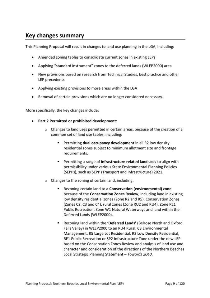
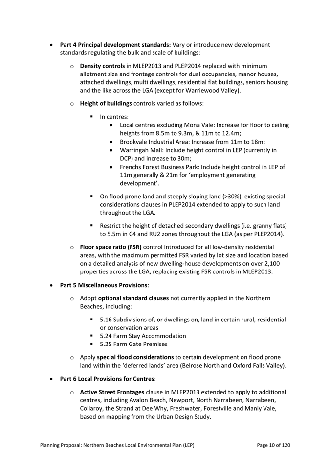
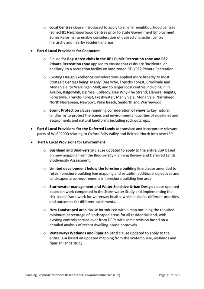
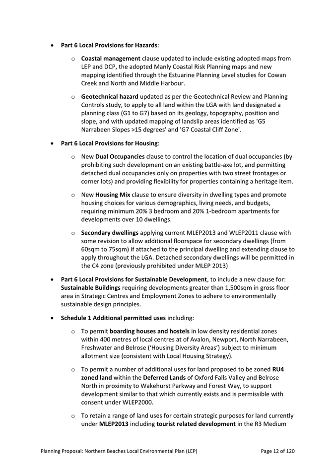
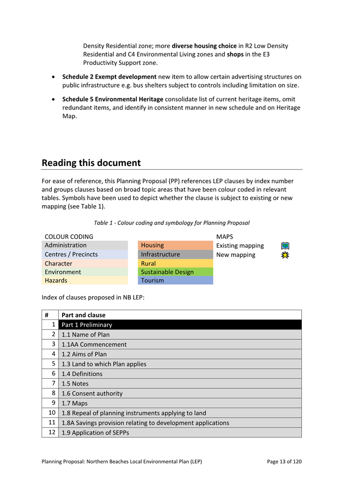
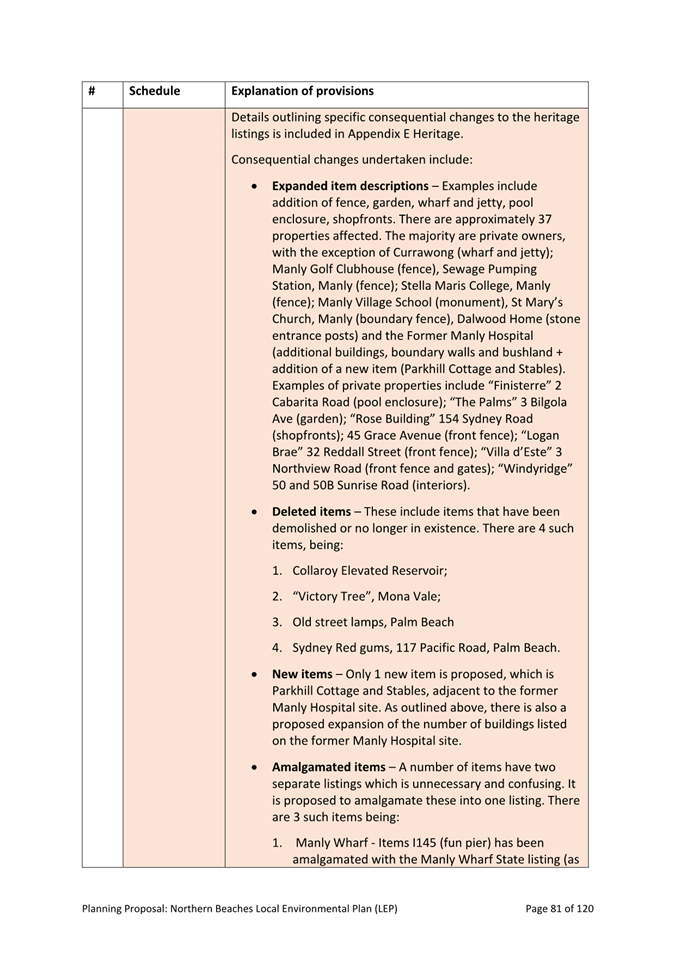
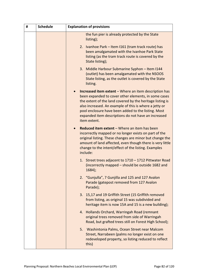
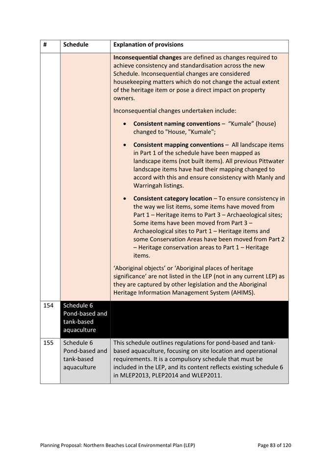
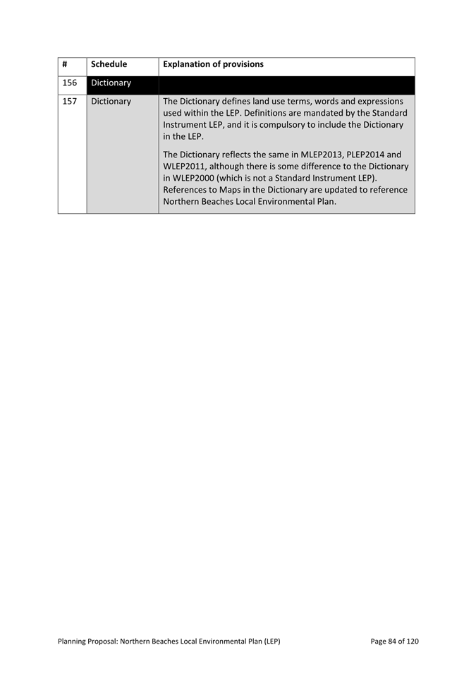
11.0 Planning and Place Division Reports
|
ITEM 11.1 |
Planning Proposal – Northern Beaches Local Environmental Plan (LEP) |
Purpose
The purpose of this report is to seek Council endorsement to submit the Planning Proposal for the new Northern Beaches Local Environmental Plan (LEP) to the Minister for Planning and Public Spaces for Gateway Determination under Section 3.34 of the Environmental Planning and Assessment Act 1979.
Executive Summary
· The Planning Proposal outlines the content, justification, and intended effect of the new, comprehensive LEP for the Northern Beaches, repealling the 4 LEPs that currently apply in the area being: Manly LEP 2013; Pittwater LEP 2014; Warringah LEP 2011; and Warringah LEP 2000.
· The LEP will guide planning decisions for the development and conservation of land on the Northern Beaches, comprising aims, land use zoning, development controls and other provisions, reflecting the priorities and principles of the Northern Beaches Local Strategic Planning Statement – Towards 2040.
· The Planning Proposal has been prepared in accordance with section 3.33 of the Environmental Planning and Assessment Act 1979 and the Department of Planning, Housing and Infrastructure’s Local Environmental Plan Making Guideline (August 2023).
· The Planning Proposal is aligned with regional and local strategies and informed by technical studies, research, spatial analysis, as well as extensive engagement with the community, Councillors, key stakeholders, and the Northern Beaches Local Planning Panel (NBLPP).
· The NBLPP considered the Planning Proposal at its meeting on 23 May 2024 and advised that the Planning Proposal is appropriate for submission to the Minister for Planning and Public Spaces for issue of a Gateway Determination.
· The LEP will be complemented by a new Northern Beaches Development Control Plan (DCP), replacing all current DCPs and which will be reported to Council separately.
· Public exhibition of the Planning Proposal (as well as the draft DCP), including extensive LGA-wide public consultation, will take place following Gateway Determination, subject to the Department’s advice and conditions.
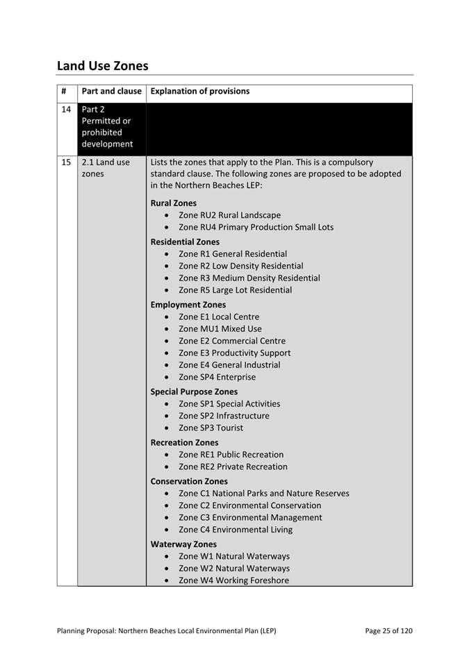
|
That: 1. Council endorse the Planning Proposal (Attachment 1 and Attachment 2) for submission to the Minister for Planning and Public Spaces for Gateway Determination. 2. Council delegate authority to the Chief Executive Officer to make any required amendments to the Planning Proposal to address minor errors or the requirements of the Department of Planning, Housing and Infrastructure which do not alter the intent or result in material changes to the Planning Proposal, prior to the commencement of any public exhibition. |
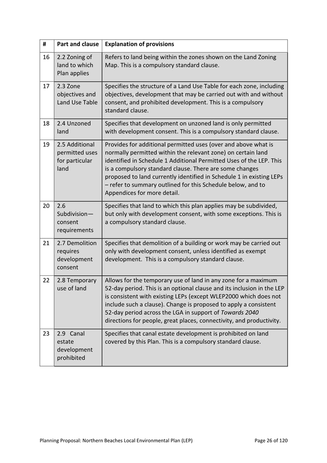
Background
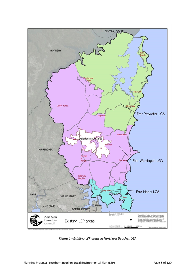
On 12 May 2016, the Local Government (Council Amalgamations) Proclamation 2016 was notified. The Proclamation resulted in the creation of the new Northern Beaches local government area (LGA); an amalgamation of the former Manly, Pittwater and Warringah LGAs.
The Proclamation required that the land use plans that applied to different parts of the LGA at the time of the boundary changes continue to apply to those areas until such time as they are replaced by new land use plans.
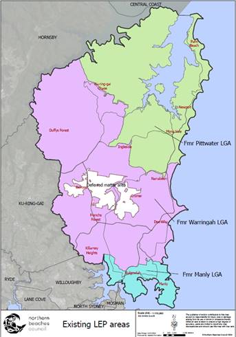
As a result, 4 different local environmental plans (LEPs) and 4 development control plans (DCPs) have applied to different parts of the LGA for the past 8 years or so (see Figure 1). This has created a complex policy framework with different rules applying to different areas despite broad similarities in character and environment.
 The proposed new Northern Beaches LEP will replace the
following existing LEPs and apply to the entire LGA:
The proposed new Northern Beaches LEP will replace the
following existing LEPs and apply to the entire LGA:
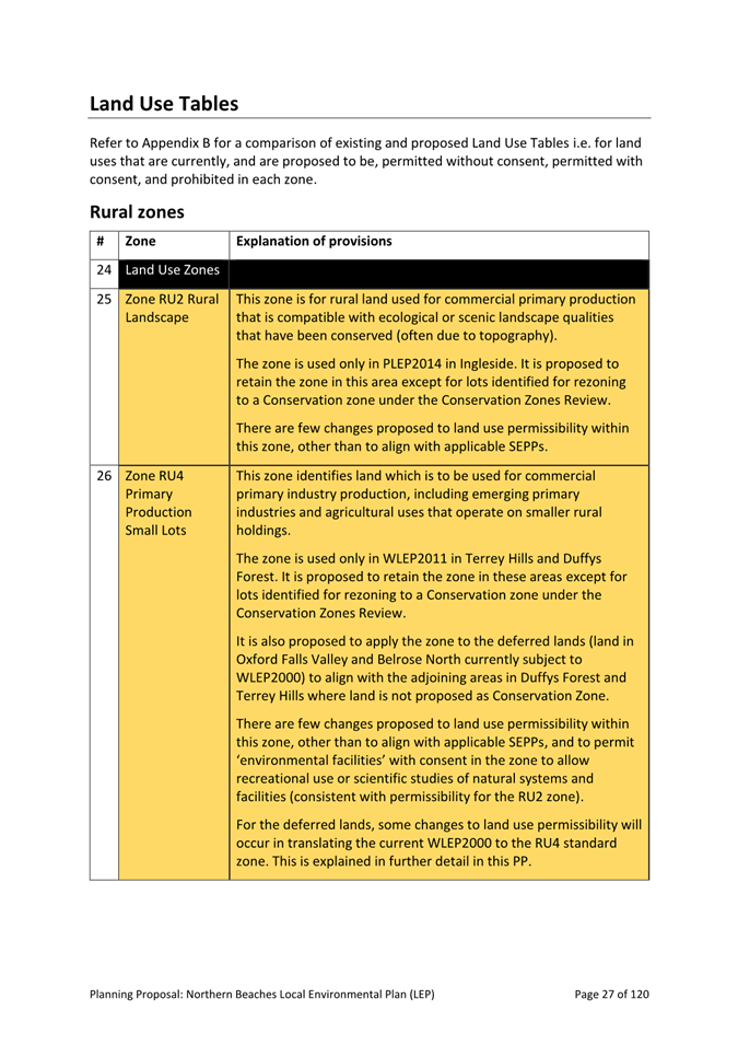
· Manly LEP 2013 (MLEP 2013)
· Pittwater LEP 2014 (PLEP 2014)
· Warringah LEP 2011 (WLEP 2014)
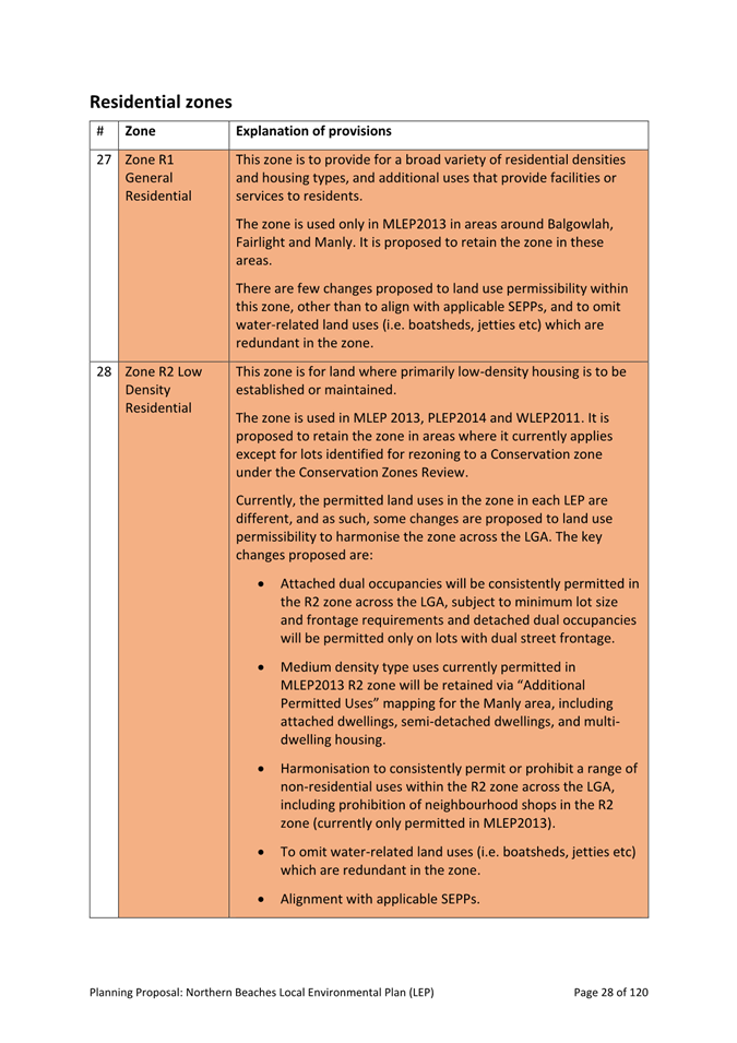
· Warringah LEP 2000 (Deferred Lands) (WLEP 2000)
The Planning Proposal seeks to create one new, consolidated set of planning rules for the whole LGA. It explains the intended effect of, and justification for, provisions within the new Northern Beaches LEP.
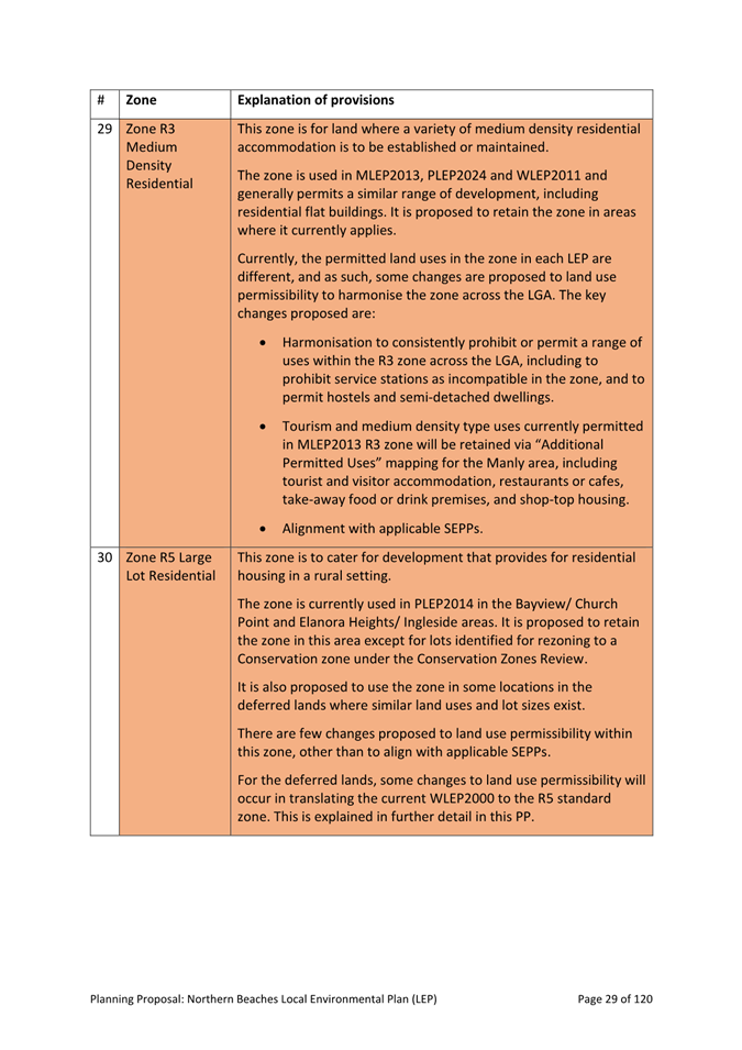
The LEP will harmonise existing provisions to create a consistent, transparent, and fair approach to land-use planning that is mindful of local character and place requirements. Where required, it will also introduce new provisions to address identified strategic priorities and community aspirations as per the ‘Planning Our Sustainable Future’ program (see below).
Figure 1 - existing LEPs that apply to the Northern Beaches LGA
The new consolidated LEP will be complemented by a consolidated DCP for the area (to be considered by Council in late 2024 / early 2025).
The Planning Proposal is the culmination of several years of strategic planning, research and technical studies, and extensive community and stakeholder consultation. This process has provided a strong evidence-base for land use planning across the LGA. As detailed below, Council has consulted closely with the NSW Department of Planning, Housing and Infrastructure (the Department) throughout this process.
Council is mindful of the Department’s recently announced intentions for low to midrise housing reform across NSW. These reforms, which are yet to be confirmed, are the subject of discussions between the Department and with councils starting in May 2024. In the absence of clear direction and detail regarding these Government-led reforms, the Planning Proposal is to proceed in its current form.
THE PLANNING PROPOSAL
LEPs provide the statutory framework that guides development and land use decisions throughout NSW. They do this through land zoning, standards for development, and matters that must be assessed when assessing development applications.
A planning proposal is the document that sets out the justification and supporting information to allow an LEP to be made under section 3.33 of the Environmental Planning and Assessment Act 1979 (EP&A Act). The EP&A Act further prescribes the standard structure, headings, and process for the Planning Proposal. The Local Environmental Plan Making Guidelines (Department of Planning and Environment, August 2023) supplements the statutory specifications to outline the practical steps to amend or create a new LEP.
The Planning Proposal (Attachment 1 and Attachment 2) is structured as per the standard template and meets all statutory and regulatory requirements.
Purpose
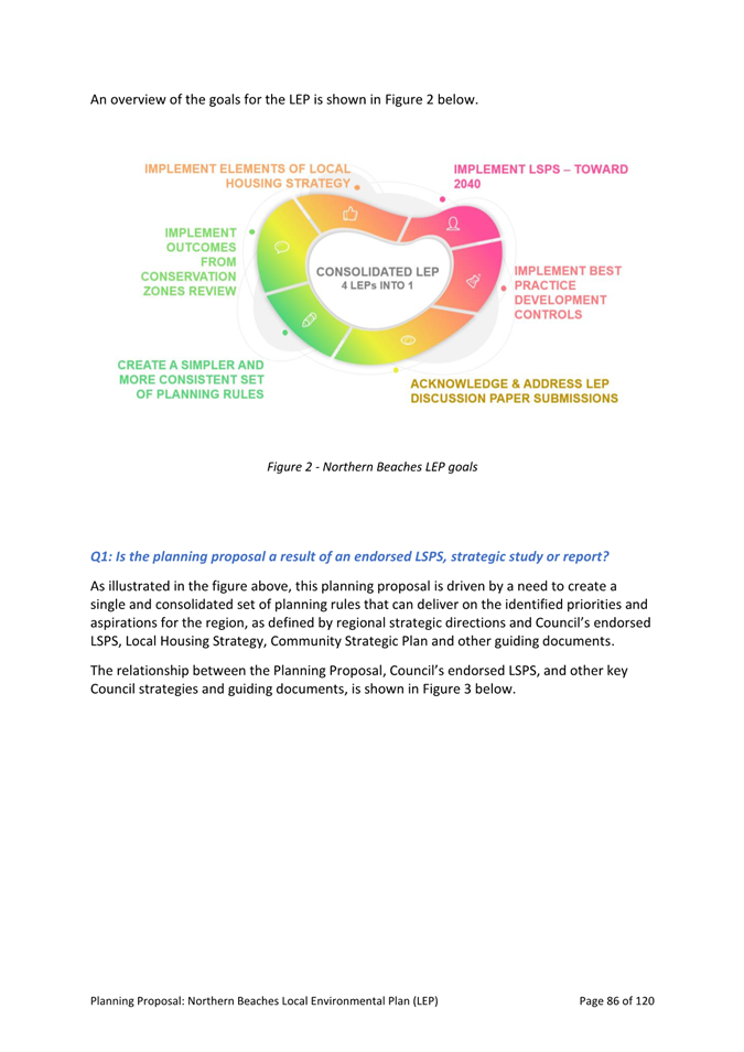
The purpose of this Planning Proposal is to create a single, consolidated LEP that will replace the 4 existing LEPs that apply to land in the Northern Beaches LGA. In consolidating current LEPs, Council intends to achieve the objectives outlined in Figure 2 below:
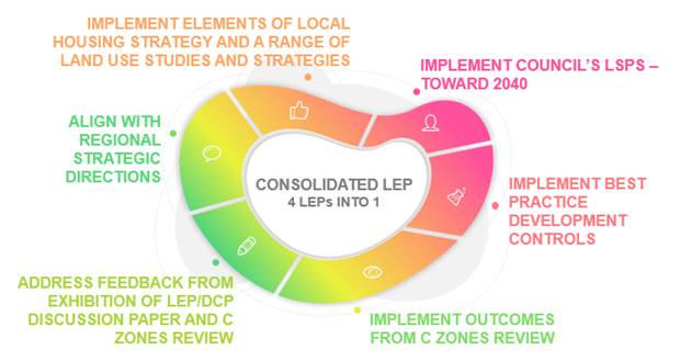
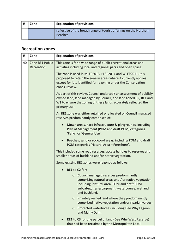
Figure 2: Northern Beaches LEP objectives
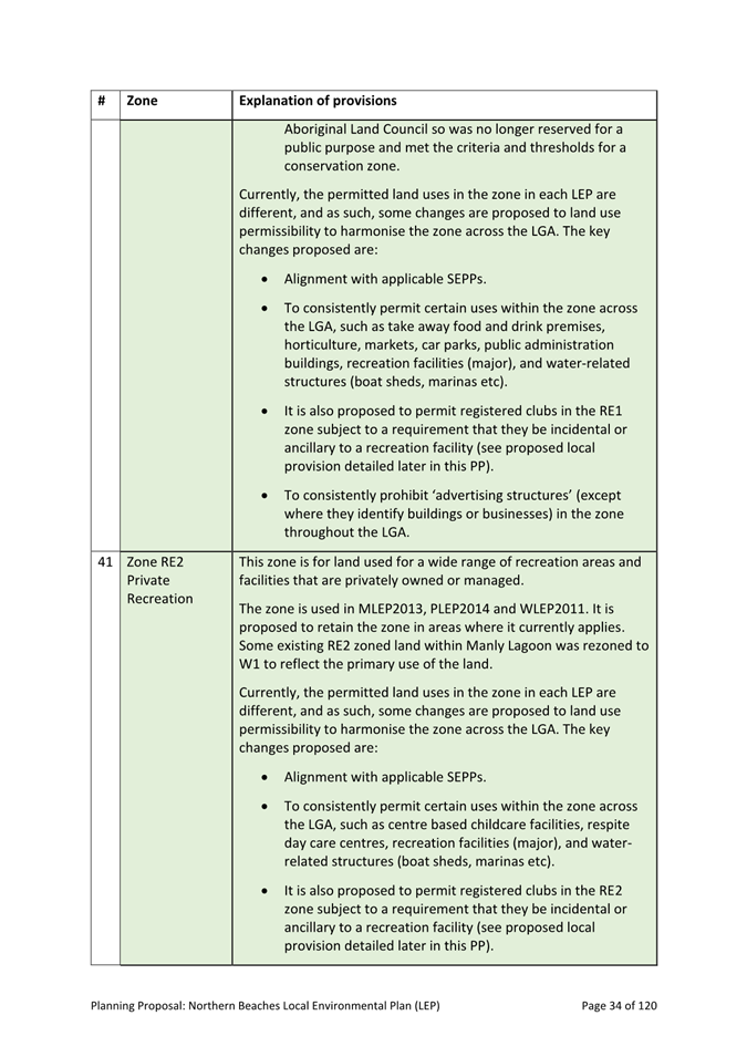
Intended outcomes
The Planning Proposal seeks to progress the community’s long-term vision as outlined in its Community Strategic Plan (CSP):
Northern Beaches – a safe, diverse, inclusive and connected community that lives in balance with our extraordinary coastal and bushland environment (CSP 2022: p19).
Guided by this vision, the Planning Proposal’s intended outcomes are:
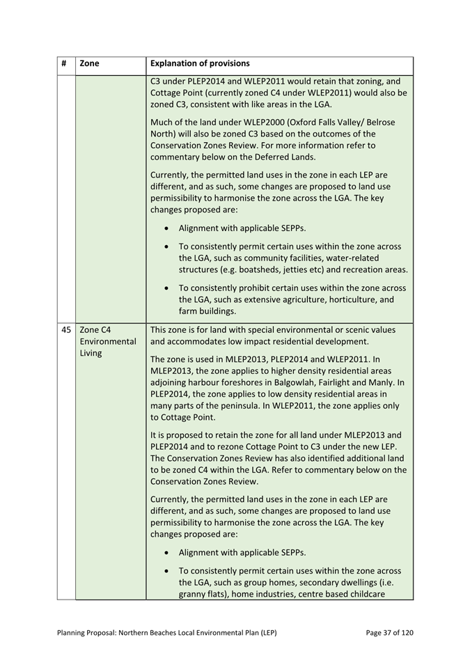
1. Protection of environmental, scenic and cultural values of our bushland, coast, waterways.
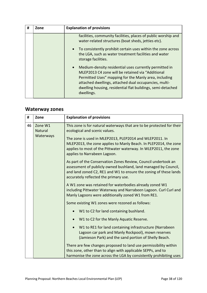
2. Avoidance of intensification, inappropriate development and incompatible land uses in hazardous areas and rural areas.
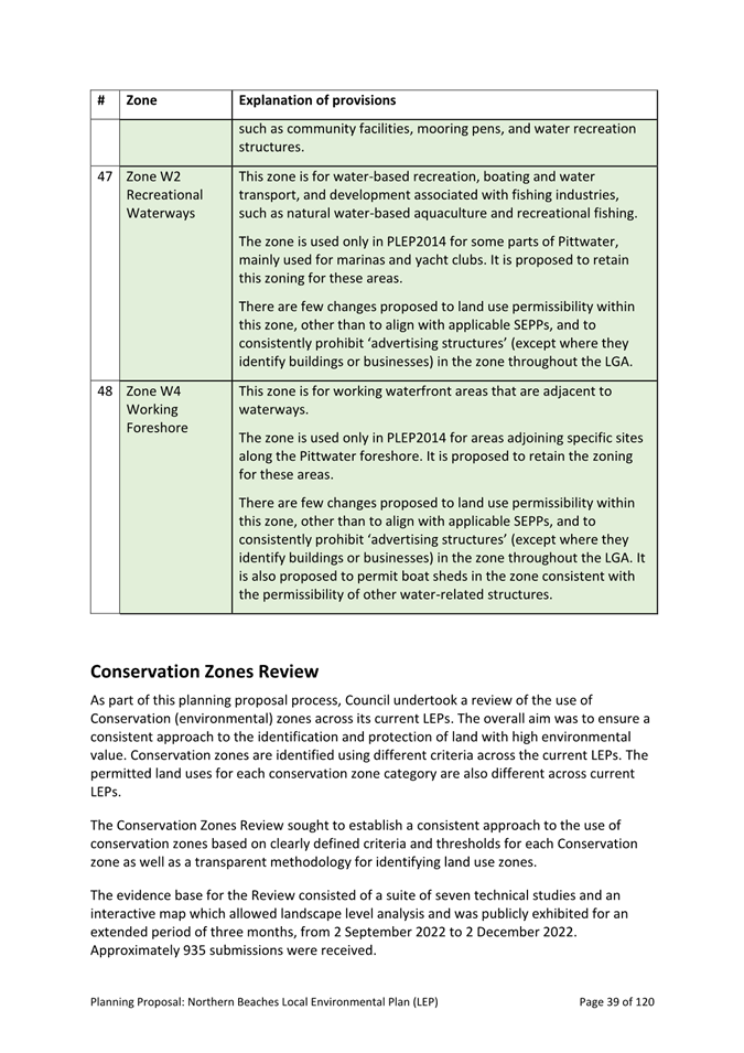
3. Provision of housing in the right locations and support for a housing mix to meet diverse community needs.
4. Urban design outcomes that support amenity and complement local character.
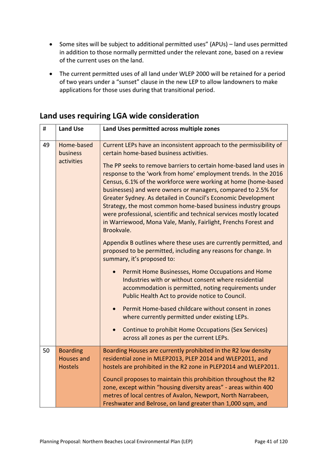
5. Environmentally sustainable design and transition to net zero developments through high energy, water and waste efficiency.
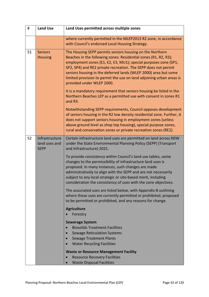
6. Safeguarding of employment lands from non-compatible uses, enabling holistic and integrated growth of centres.
7. Provision of public benefits (open space, affordable housing, amenity) and community facilities and services that meet changing community needs.
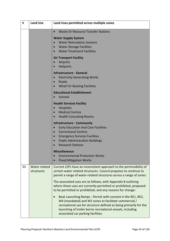
8. Support for creation of liveable communities (e.g. increasing tree canopy, reducing urban heat, delivering amenity, supporting sustainable transport).
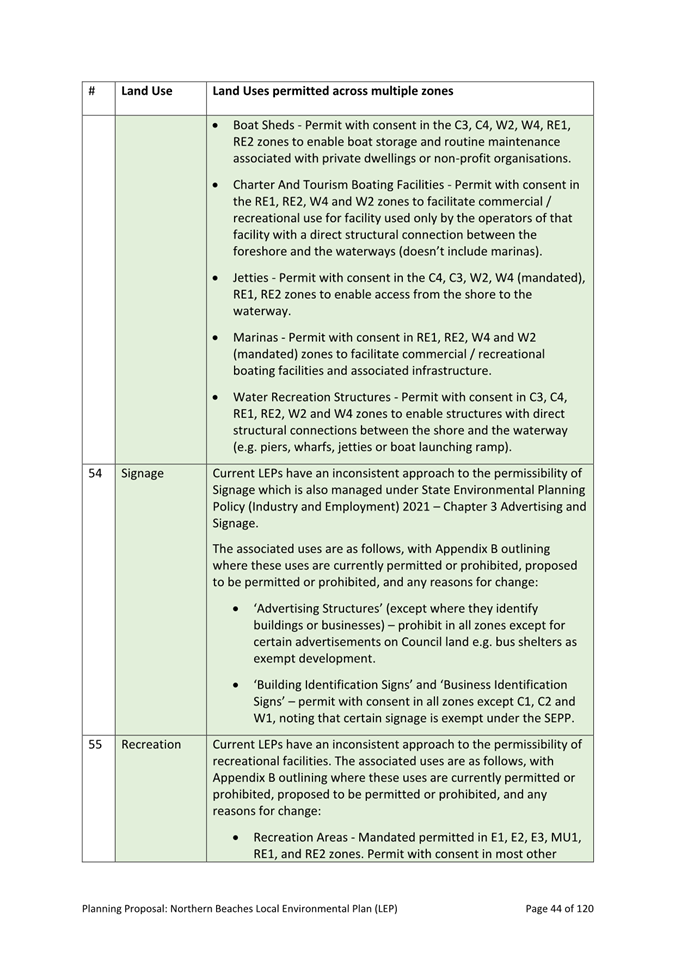
DISCUSSION
The Northern Beaches LEP will be Council’s principal land use planning document to guide and regulate the development and conservation of land in the LGA.
The Planning Proposal provides a plain English explanation and justification for the provisions proposed to be included in the LEP, including its proposed aims, land use zones, development standards and other planning controls – and comparison with existing LEPs.
Merging 4 existing LEPs into a new consolidated LEP for the LGA is complex. While there are many similarities in these documents, there are also many differences. Many controls must be reconciled to create a single, clear, fair and locally relevant LEP, that is consistent with State and local policy direction, and with legislation governing the preparation of an LEP in NSW.
LEP Proposed Key Changes
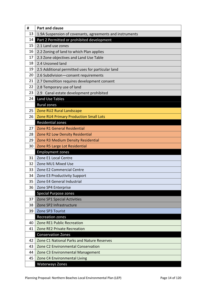
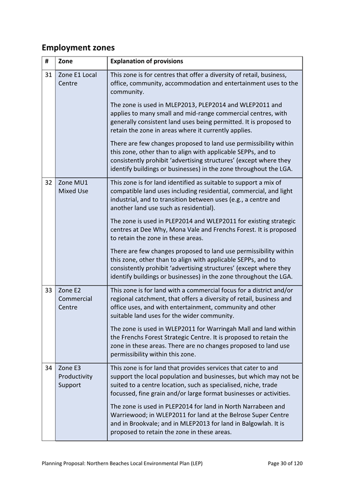
Land use zones
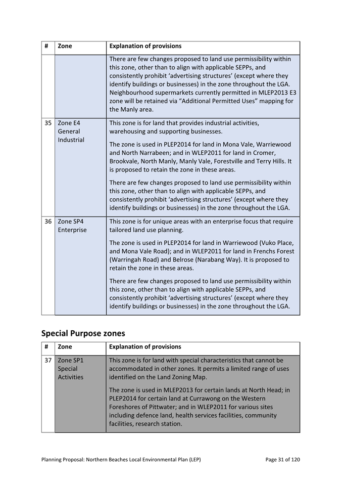
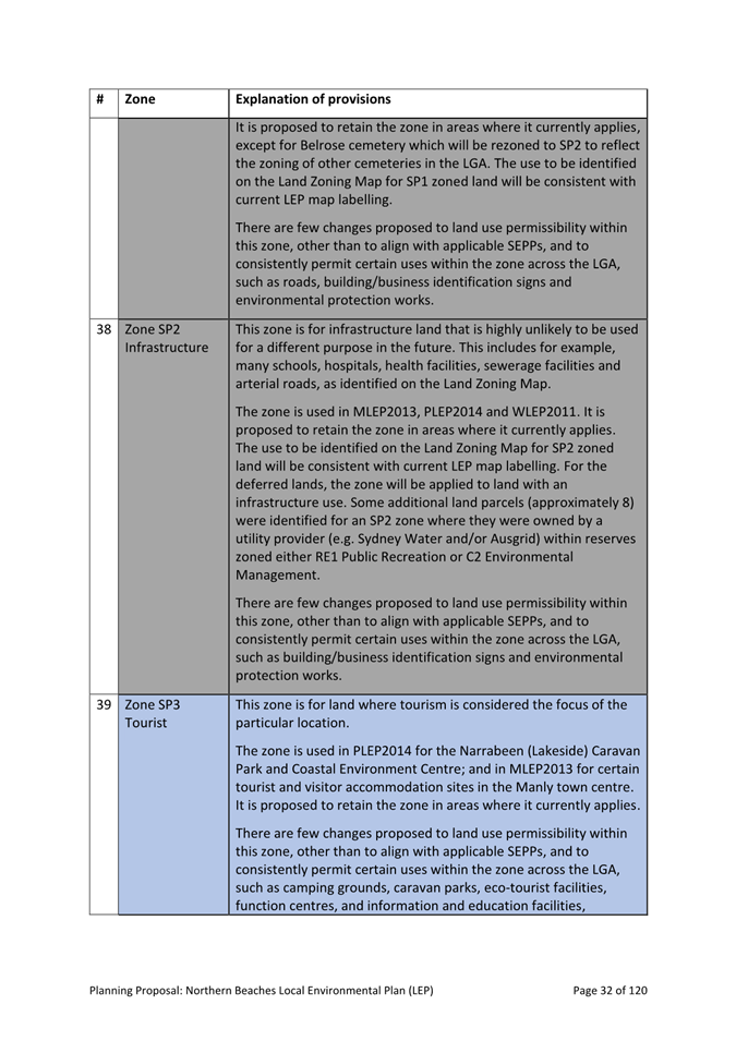
· The Planning Proposal includes 24 land use zones to apply across the LGA – consolidated from 15 zones in MLEP2013, 21 zones in PLEP2014, 18 zones in WLEP2011, and two locality statements in WLEP2000. The application of zones i.e. the land to which current zones apply, and the permissible land uses in each zone, will generally remain the same, however the permissibility of certain land uses in some zones has changed to achieve consistency across the LGA.
· A number of rural and residential properties will be re-zoned to a (environment) Conservation zone as a result of Council’s Conservation Zones Review, including in Oxford Falls Valley, Belrose North, Ingleside, and Bayview, as well as in some urban locations where high environmental values have been identified (see Consultation section below and Appendix H to the Planning Proposal – “Conservation Zones Review – Outcomes and Implications”).
· Zones under the Standard Instrument LEP planning framework will be applied to the ‘deferred lands’ (Belrose North and Oxford Falls Valley) currently regulated by WLEP2000, based on the Conservation Zones Review, analysis of land use and character, and consideration of the directions of the Northern Beaches Local Strategic Planning Statement – Towards 2040. This is discussed in further detail below.
· Rezoning of certain publicly owned land to reflect the primary use of the land, including rezoning of some Council parks and waterways to C2 Environmental Management and W1 Natural Waterways to ensure better protection of land with high environmental values.
· Retain permissibility of certain housing types currently permitted in the Manly LEP 2013 R2 zone e.g. multi-dwelling housing, to facilitate opportunities for more diverse and affordable housing, consistent with Council’s Local Housing Strategy (maintained through ‘additional permitted use’ provisions to be identified in Schedule 1 of the LEP).
· Registered clubs will be permitted in the RE1 Public Recreation zone and RE2 Private Recreation zone subject to them being ’incidental or ancillary’ to a recreation facility on the land consistent with several existing sites across the LGA.
· A range of infrastructure related land uses will be permitted in zones throughout the LGA to align with permissibility under State Environmental Planning Policy (Transport and Infrastructure) 2021, for example, schools and emergency services facilities.
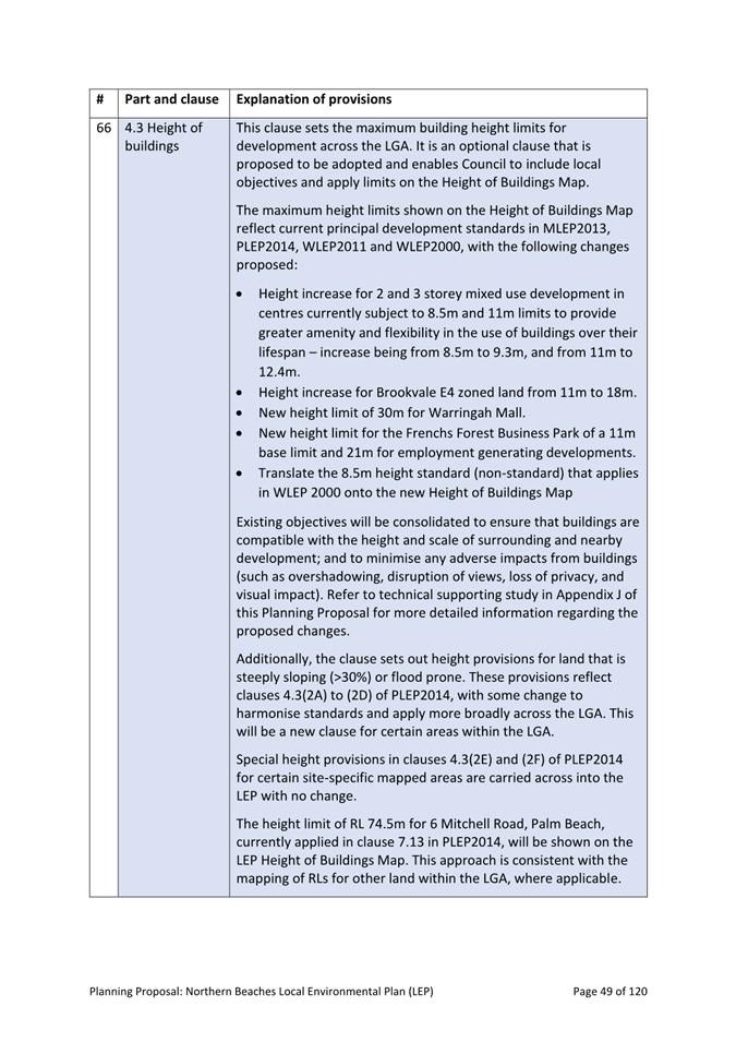
· Road reserves have been rezoned either RE1 Public Recreation or C2 Environmental Conservation to reflect Council managed reserve boundaries. The zoning of other road reserves will be completed following confirmation from the Department of the proposed approach and prior placing on public exhibition.
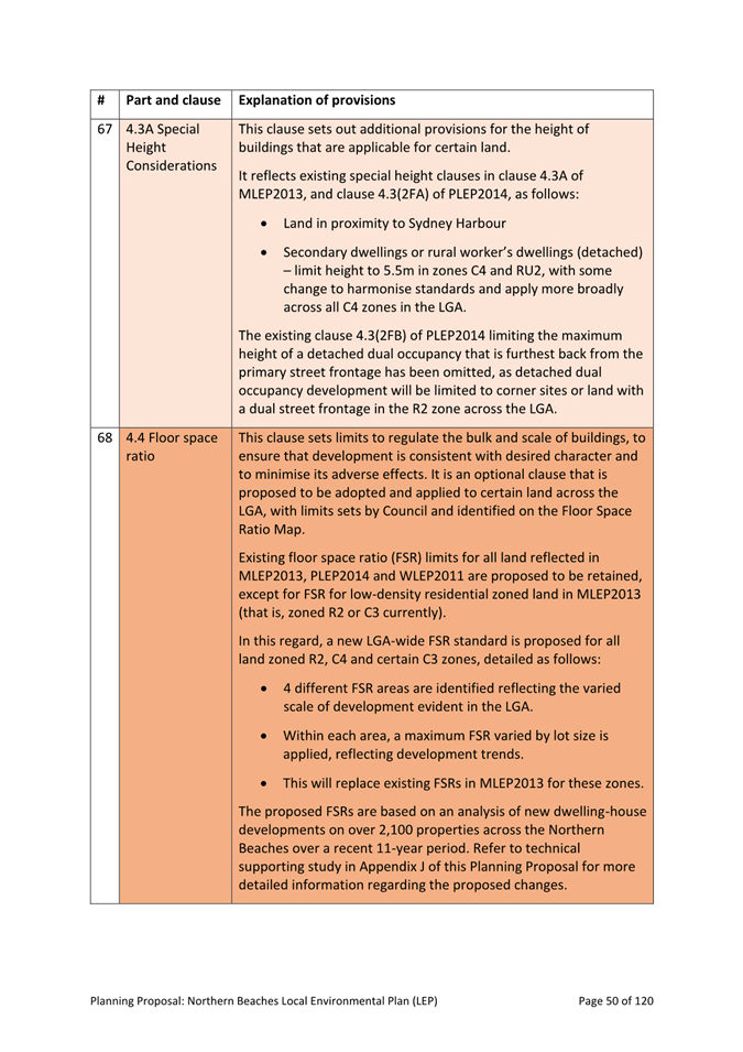
Housing
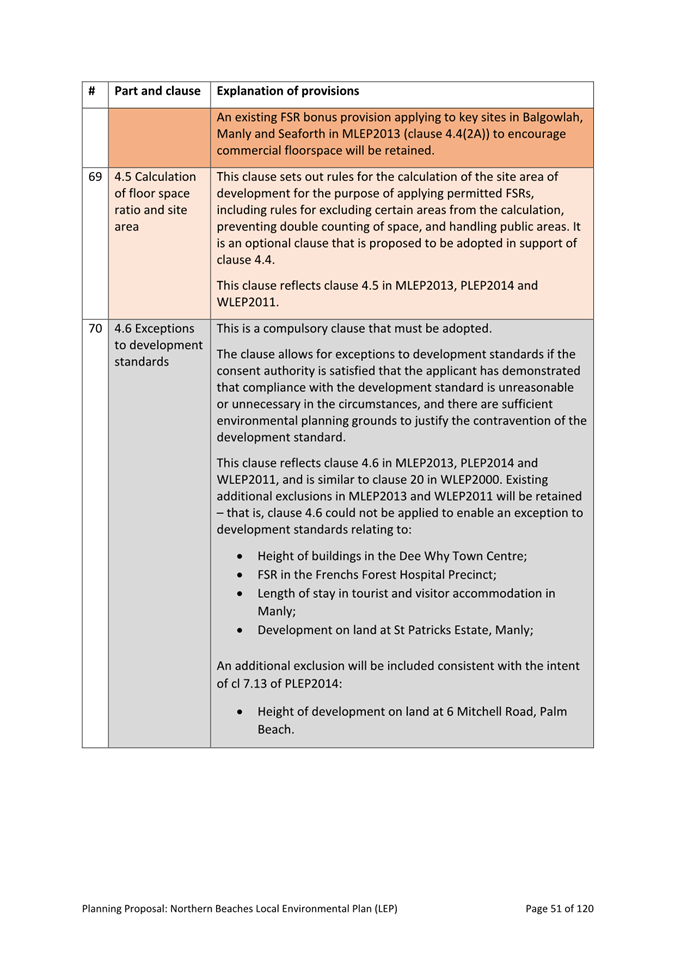
Consistent with the Northern Beaches Local Housing Strategy, the proposed changes to housing provisions seek to enable greater housing diversity while protecting local character and amenity in residential areas by controlling for bulk, scale and sizes of lots that can be used for additional housing.
· Attached dual occupancy development will be permitted in the R2 Low Density Residential zone throughout the LGA with a minimum allotment size of 800sqm and 18m site frontage, with detached dual occupancy development being permitted on sites with a dual street frontage (WLEP2011 does not currently permit dual occupancy in the R2 zone).
· Housing Diversity Areas will apply within 400 metres walking distance of land zoned E1 Local Centre in the R2 zone at Avalon, Newport, North Narrabeen, Freshwater and Belrose, within which boarding houses and hostels will be permitted on sites of 1,000sqm or more.
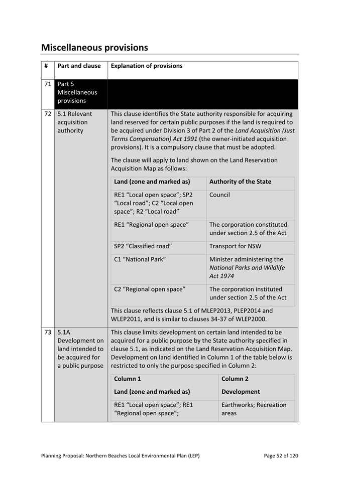
· Secondary dwellings (e.g. ‘granny flats’) provisions will be harmonised to apply a maximum floor area of 60sqm, or 25% of the total floor area of the principal dwelling (whichever is greater), and 75sqm if attached to the principal dwelling. The height of detached (e.g. ‘stand-alone’) secondary dwellings will be limited to 5.5m in C4 and RU2 zones.
· A maximum floor space ratio (FSR) standard will be introduced in low density residential zones, based on locality and lot size, to better regulate the bulk and scale of development. This will replace existing FSRs applying under MLEP2013 and is a new requirement in other parts of the LGA.
· New minimum allotment size and street frontage requirements will apply to certain types of medium density housing (multi dwelling housing, residential flat buildings and the like), replacing current density controls in MLEP2013 and PLEP2014, apart from the Warriewood Valley Release Area, which retains density controls which are linked to environmental capacity.
· A new provision for housing mix will be introduced to apply to residential flat buildings comprising 10 or more dwellings, requiring a minimum 20% 1-bedroom and 20% 3-bedroom dwellings to be included in the design. The intent is to ensure greater diversity in dwelling types and promote housing choices for various sectors of the community, living needs, and budgets.
Centres
Consistent with the Greater Sydney Region Plan, North District Plan, and Council’s Local Strategic Planning Statement (LSPS), the following changes are proposed to protect the viability of centres, encourage business opportunities, facilitate good design outcomes, and promote vitality and amenity:
· The maximum building height will be changed in some centres: In local centres (excluding Mona Vale), increase from 8.5m to 9.3m, and from 11m to 12.4m, to facilitate greater floor to ceiling heights. In Brookvale Industrial area, increase from 11m to 18m. At Warringah Mall, establish a height limit of 30m consistent with existing development. In Frenchs Forest Business Park, apply a height limit of 11m generally and 21m for ‘employment generating development’.
· The existing Active Street Frontages clause applying in MLEP2013 (to Balgowlah, Manly and Seaforth Centres) will be extended to apply to additional larger local centres including Avalon Beach, Newport, North Narrabeen, Narrabeen, Collaroy, the Strand at Dee Why, Freshwater, Forestville and Manly Vale, to promote pedestrian-friendly environments and retail activity.
· A new clause, Development in Local Centres, will be introduced to consider the scale and function of development proposed in smaller neighbourhood centres across the LGA. This is proposed in response to the NSW Government’s recent Employment Zone Reforms which saw the merge of the former B1 Neighbourhood Centre and B2 Local Centre Zones into one E1 Local Centre Zone, and as a result, a loss of centres hierarchy.
· Design Excellence considerations will be applied more broadly to all Strategic Centres in Manly, Dee Why, Frenchs Forest and Mona Vale, to Warringah Mall, and to larger local centres in Avalon, Balgowlah, Belrose, Collaroy, Dee Why-The Strand, Elanora Heights, Forestville, Frenchs Forest, Freshwater, Manly Vale, Mona Vale, Narrabeen, North Narrabeen, Newport, Palm Beach, Seaforth and Warriewood. The clause aims to ensure a high standard of architectural and urban design for new buildings or external alterations of existing buildings.
Environment and Natural Hazards
The engagement for this project confirmed that the protection of the unique environmental values of the Northern Beaches remains of critical importance to the community.
Guided by the broad range of environmental technical studies and strategies developed by Council and directly informed by the Northern Beaches Environment Study as well as technical studies which provides specific planning recommendations, the Planning Proposal takes an evidence-based approach to protecting the environment:
· New or updated LEP clauses are proposed to apply more broadly across the LGA based on technical studies exhibited in 2022 as part of the Conservation Zones Review. The clauses require more detailed consideration of certain environmental matters in identified areas:
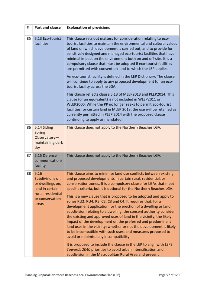
- Bushland and Biodiversity clause – based on new mapping from the Biodiversity Planning Review and Deferred Lands Biodiversity Assessment, the clause aims to protect and conserve native fauna and flora.
- Waterways Wetlands and Riparian Land clause – based on updated mapping from the Watercourse, Wetlands and Riparian lands study, the clause aims to protect and maintain water quality, bank and bed stability, ecological process, and aquatic and riparian habitats map.
- Geotechnical planning – based on the Geotechnical Review and Planning Controls study, the clause designates land with a planning class (G1 to G7) based on its geology, topography, position and slope, and includes updated mapping of landslip areas identified as ‘G5 Narrabeen Slopes >15 degrees’ and ‘G7 Coastal Cliff Zone’.
- Coastline hazard management – based on existing adopted maps, the adopted Manly Coastal Risk Planning maps and new mapping identified through the Estuarine Planning Level studies for Cowan Creek and North and Middle Harbour, the clause aims to avoid significant adverse impacts from coastal hazards.
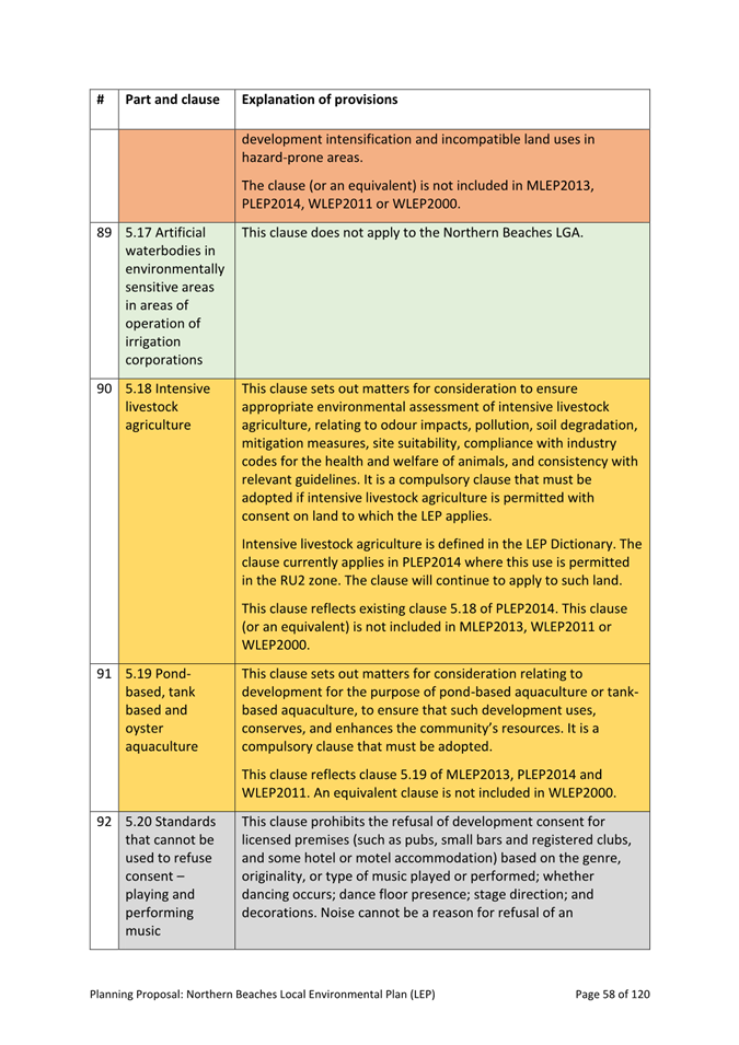
· A new Scenic Protection clause will be introduced to apply across the LGA to protect the scenic and environmental qualities of ridgelines and escarpments and natural landforms including rock outcrops. It is based on existing provisions in WLEP2011 and WLEP2000.
· Retention of foreshore building lines identified in MLEP2013 and PLEP2014 and updating of related LEP clause to establish additional matters for consideration e.g. retention of landscaping in foreshore areas. It is not intended to apply the clause more broadly across the LGA currently, as additional research is required which is beyond the scope of LEP work.
· A Stormwater Management and Water Sensitive Urban Design clause will be applied to all development with consent across the LGA to reflect the recommendations of Council’s Stormwater Study, implementing the risk-based framework for waterway health, which includes different priorities and outcomes for different catchments.
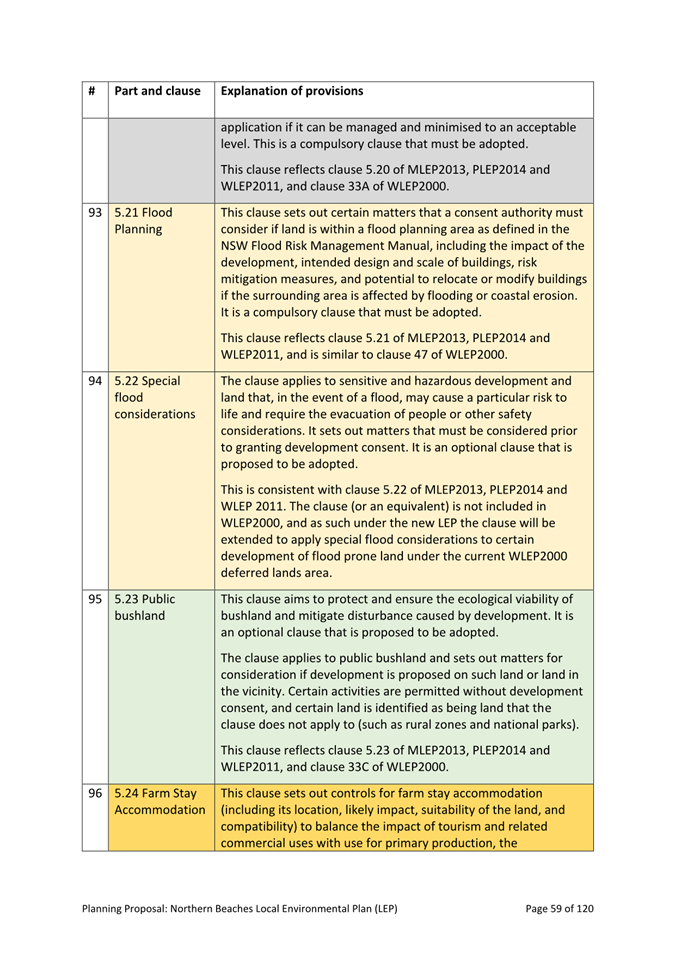
· Minimum requirements for landscaped area in low density residential zones will be included in the LEP and updated (currently in DCPs) based on a detailed analysis of recent dwelling-house approvals and current requirements.
· On flood prone land and steeply sloping land (>30%), existing special considerations clauses in PLEP2014 facilitating an increase in the height of buildings will be extended to apply to such land throughout the LGA provided there are no additional environmental impacts. This provision will enable resilience measures such as raising the height of a house above flood levels.
Sustainable development
The Community Strategic Plan (CSP) identifies environmental sustainability as a core community aspiration: “Our community aspires to be leaders in managing our resources sustainably and for the long term to ensure that development is balanced with our lifestyle and environment” (CSP 2022: page 28).
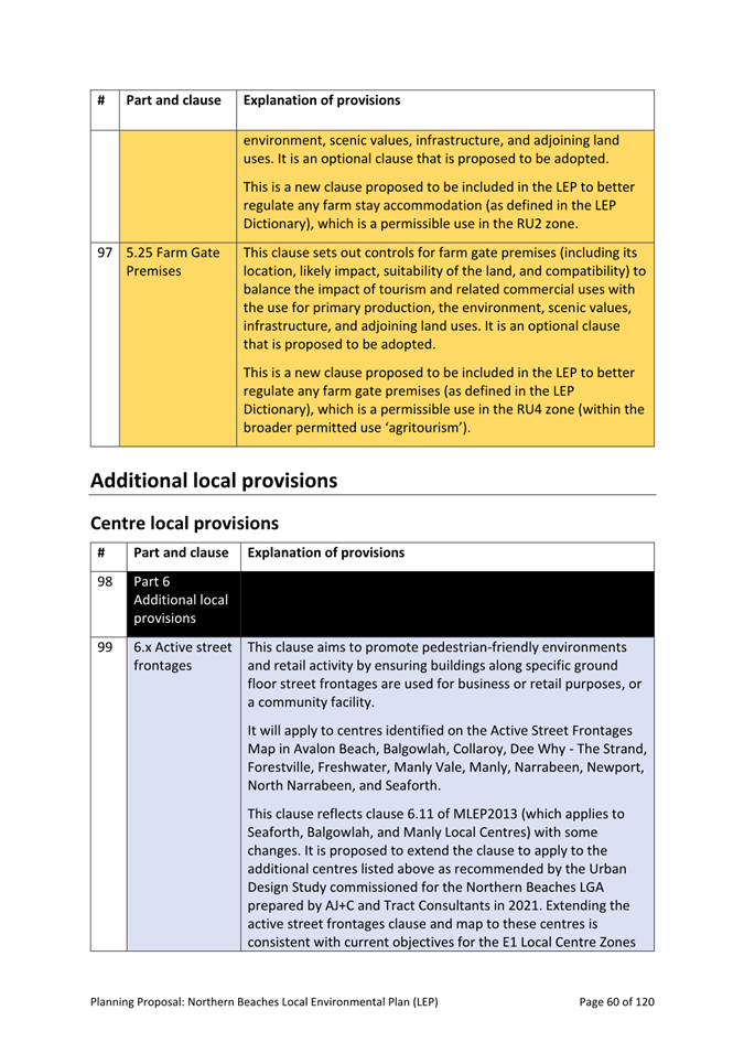
This aspiration was re-iterated in the engagement for the LEP/DCP Discussion Paper, with community members expressing a strong interest in environmental sustainability and urging Council to become a leader in this field and reduce the environmental footprint of buildings.
While the community expectations are clear, from a planning perspective sustainability is complex. This area is largely governed by State policies (the Sustainable Buildings SEPP) and national standards (National Construction Code – NCC).
Currently, councils are not permitted to set higher standards than those included in the Sustainable Buildings SEPP and the NCC. However, councils can make policy and plans in areas that do not conflict with these standards.
The following change is proposed to address the identified community aspiration (and noting that Council is taking other action outside of the LEP to promote sustainable development throughout the LGA – see the Environment and Climate Change Strategy):
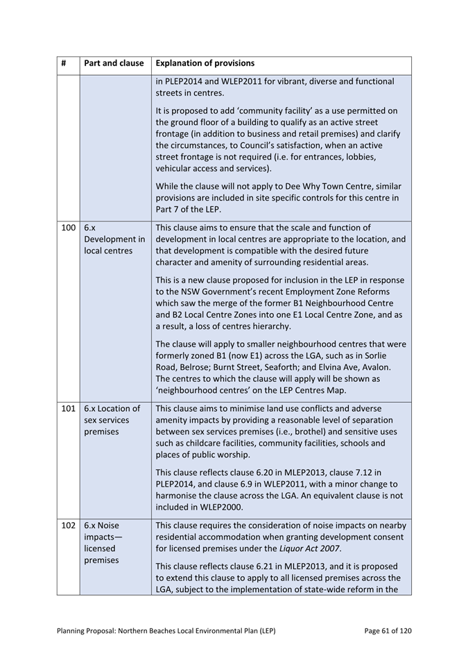
· A new clause for Environmental Sustainability will be introduced to apply to large-scale development (greater than 1,500sqm floor area) in Employment and Residential Zones requiring consideration of a range of design principles including water and energy demand reduction, indoor environmental quality, heat absorption reduction, urban greening, passive design, and transport initiatives promoting reduced car dependence. A scored checklist will support application of the clause.
In addition, many of the controls contained in “Environment and Hazards” section above will positively impact the sustainability of all future development.
Deferred Lands
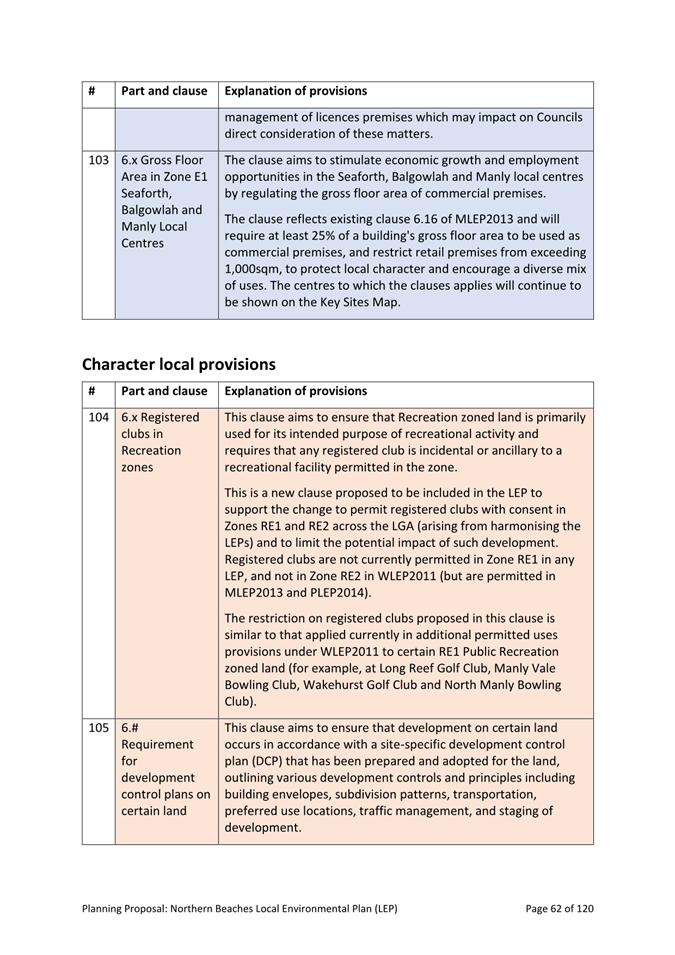
Land within Oxford Falls Valley and Belrose North (known as the ‘deferred lands’) is currently subject to WLEP2000, which is a ‘place based’ LEP no longer supported by the NSW Government.
Changes will occur in moving WLEP2000 into the required LEP format set by the Standard Instrument (Local Environmental Plans) Order 2006, as standardised land use zones, clauses and definitions must now be applied.
Land within this area will be zoned a mix of RU4 Rural, C3 Environmental Management, R5 Large Lot Residential, R2 Low Density Residential, RE1 Public Recreation or SP2 Infrastructure Zone under the new LEP, based on the Conservation Zones Review, analysis of land use and character, and consideration of the directions of the Northern Beaches Local Strategic Planning Statement – Towards 2040.
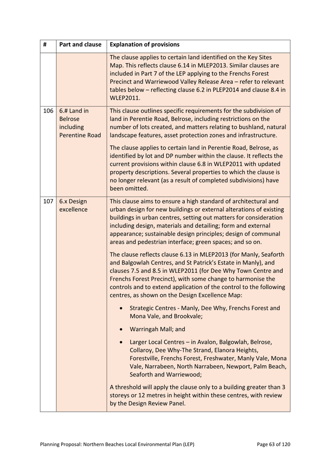
Other key proposals for the Deferred lands include:
· Sunset clause: The current permitted uses of all land in the deferred lands will be retained for a period of two years under a “sunset” clause in the new LEP to allow landowners to make applications for those uses during a transitional period. Development consents granted during this transitional period must be commenced within five years of the consent being granted.
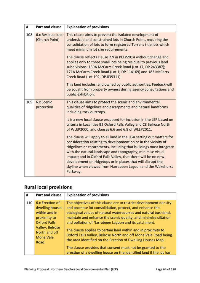
· APUs: Selected sites will be subject to “additional permitted uses” (APUs) – land uses permitted in addition to those normally permitted under the relevant zone, based on the current nature of land uses in the area.
· Retention of minimum lot size controls for the subdivision of land and for the erection of dwelling houses in areas zoned RU4 and C3 to maintain existing character. Land proposed to be zoned in other zones e.g., R2 and R5 will be subject to changed controls reflecting controls in similar areas in the Council area.
· Application of Split Zones (usually part C3/ part RU4) on large lots where some of the land may have been cleared and no longer presents environmental values that would trigger a conservation zone.
· Application of zones other than conservation zones based on site-by-site assessment of existing values and uses.
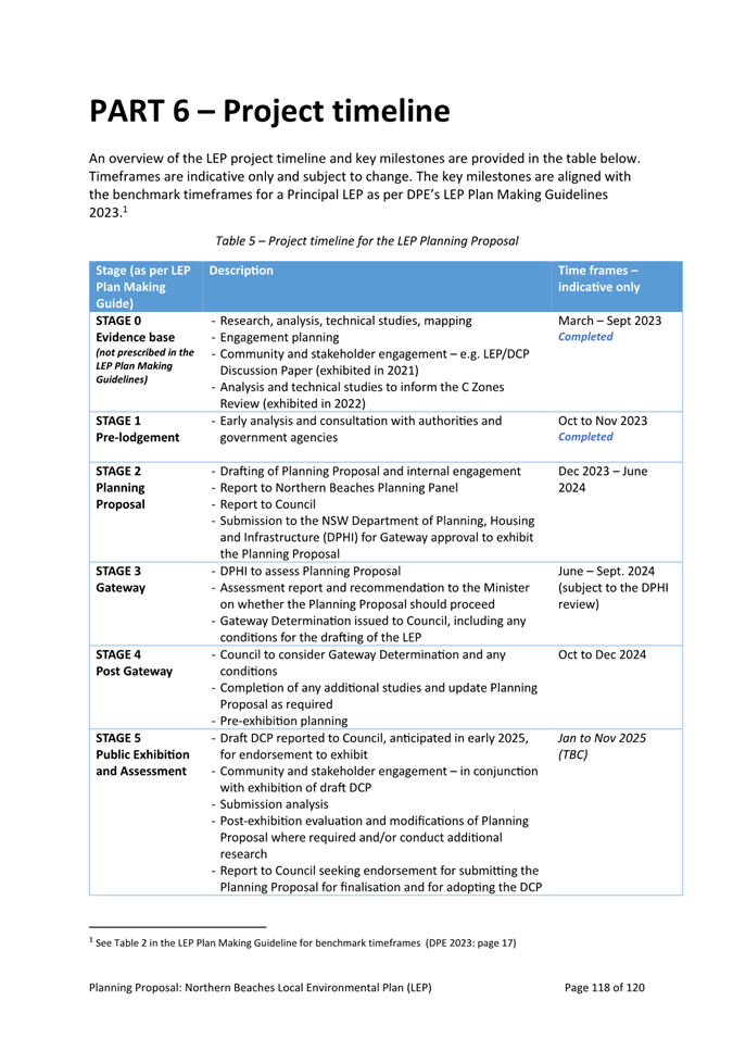
PLANNING PROPOSAL PROCESS
An overview of the process Council used to develop the Planning Proposal is shown in Figure 3 below and further described in the following. (The steps below align with the Pre-lodgement and the Planning Proposal stages of the Department’s LEP Plan Making Guidelines). Community engagement was a core element of this process and hence described in more detail in the following section.
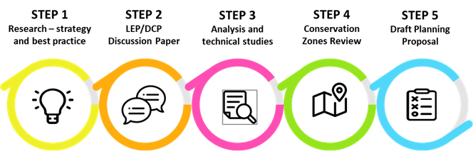
Figure 3 Preparation of the Planning Proposal
· Analysis of strategic context (regionally and locally) was undertaken to ensure alignment with guiding regional and local directions as well as good planning practice
· An analysis of the four existing LEPs was undertaken to identify what works well, as well as identify areas for improvement and further research. This was used as a starting point for best practice analysis to identify specific development controls that work well elsewhere.
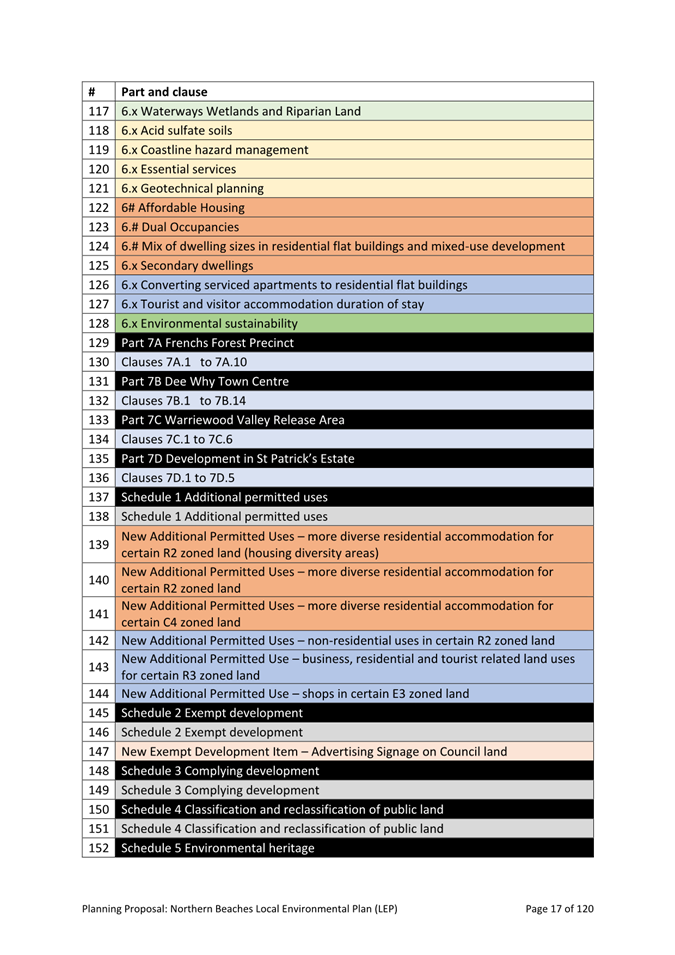
· Identified strengths were used as basis for identifying possible harmonisation and extension of controls across the whole LGA.
![]()
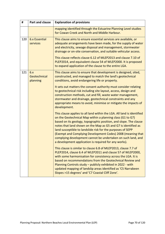
· Informed by the initial research and analysis, a comprehensive LEP/DCP Discussion Paper was prepared. The purpose was to inform discussions with the community about the need for simplified and consolidated planning rules for the whole LGA.
· The LEP/DCP Discussion Paper was presented to Council at its meeting held on 15 June 2021, where Councillors resolved to place the document on public exhibition.
· The LEP/DCP Discussion Paper and supporting materials were placed on extended public exhibition (from Friday 25 June to Sunday 5 September 2021). Consultation feedback has been being considered in the Planning Proposal. (See further detail below in the Consultation section of this report)
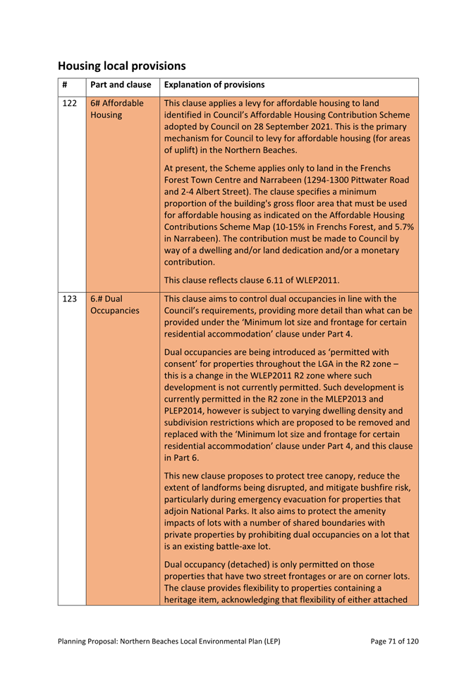
· The results from the engagement were made public via Council’s website in the report titled “Community and Stakeholder Engagement Report: Local Environment Plan / Development Control Plan Discussion Paper”
![]()
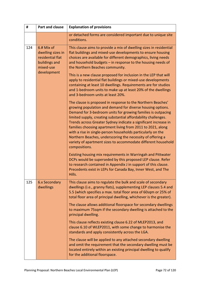
· This step focussed on providing in-depth spatial and technical analysis on items and areas of identified priority.
· The following technical studies have provided the basis for identification of areas with environmental value and significant environmental hazards. These studies have also assisted with the preparation of specific clauses for the Planning Proposal. (See the Appendix J to the Planning Proposal for an overview of technical studies and how they have been applied).
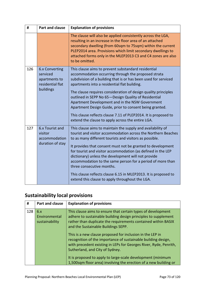
- Deferred Lands Strategic Bushfire Assessment
- Deferred Lands Biodiversity Assessment
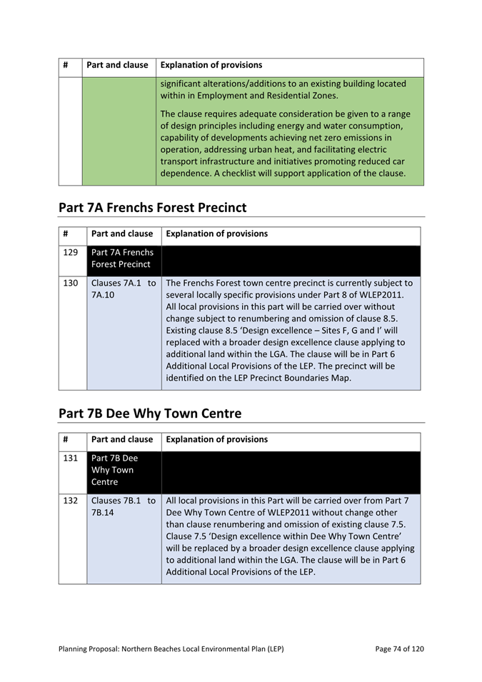
- Biodiversity Planning Review
- Watercourse, Wetlands and Riparian Study
- Cowan Creek Estuarine Planning Levels Study
- North and Middle Harbour Estuarine Planning Level Study
- Stormwater Management Study
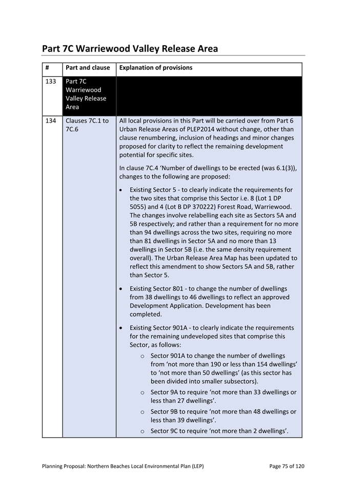
- Geotechnical
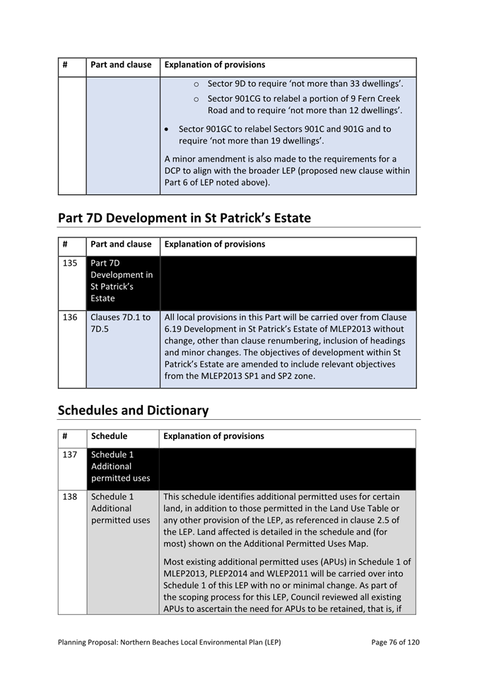
Review – Geotechnical Planning Controls.![]()
· The purpose of the Conservation Zones Review was to identify areas with high environmental value and to develop a consistent zoning approach to this land. It is described in detail in Appendix H to the Planning Proposal – “Conservation Zones Review – Outcomes and Implications” (Meridian Urban 2024).
· The Conservation Zones Review consisted of a comprehensive report, outlining the proposed draft methodology for land use zoning across the LGA. It was accompanied by the detailed technical studies (see above), supporting materials, and interactive mapping. The interactive mapping allowed users to zoom in to property scale. It also provided the rationale for proposed rezonings - both as written summaries, as well as in spatial form (e.g. through mapping overlays of key criteria that may have triggered a re-zoning).
· Conservation Zones draft methodology – key aspects
- Consistent application of zoning criteria and methodology across the LGA
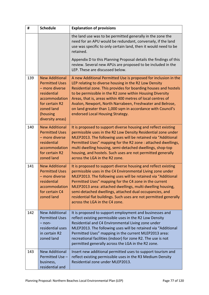
- For areas subject to identified natural hazards (e.g. flooding, bushfires), a conservation zone was proposed to apply to avoid intensification of development in these high-risk areas, hereby reducing exposure of people and property to hazards.
- Application of buffer zones for areas bordering onto areas of high conservation value and/or subject to natural hazards
- Weighted criteria, including definitions and thresholds for identification of High Environmental Value (HEV) and Medium Environmental Value (HEV)
· Council meeting and public exhibition
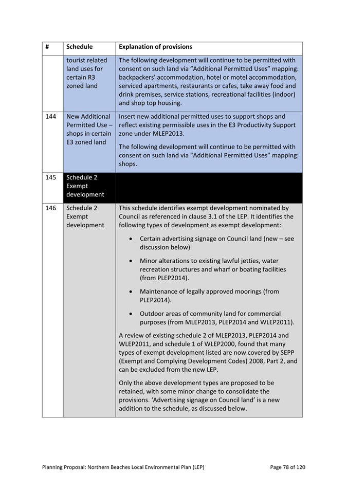
- The Conservation Review was presented to Council at its meeting held on 23 August 2022, seeking endorsement for public exhibition.
- At this meeting, Council resolved to publicly exhibit the Conservation Zones Review and associated technical studies and interactive mapping.
- Council also resolved that any disputes relating to proposed land-use zonings would be considered by an independent review, including site inspection, prior to any lands being re-zoned.
- The Conservation Zones Review was placed on public exhibition for an extended 3-month period, from 2 September to 2 December 2022. The results from the engagement were published by Council’s independent consultant, Meridian Urban and made public via Council’s website in the report titled “Conservation Zones Review Consultation Report – March 2023”. The results are summarised at Appendix H to the Planning Proposal.
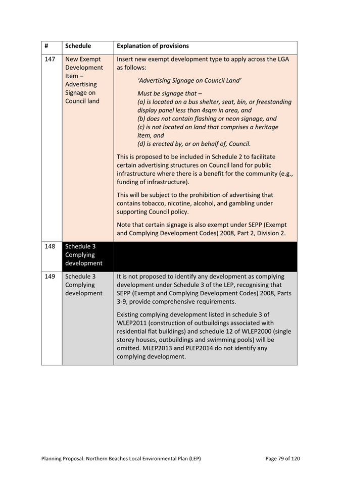
· Revised criteria and methodology for land use zonings
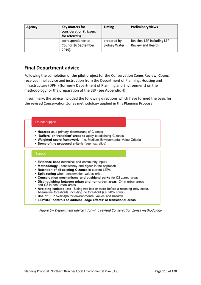
- A pilot study to test key aspects of the methodology was undertaken in collaboration with the Department from June 2023 to July 2023. This was in addition to earlier engagement with the Department which took place progressively during the drafting of the Conservation Zones methodology.
- In late November 2023, Council received final advice from the Department, giving direction to permit finalisation of the methodology. Amongst other things, the advice directed Council to:
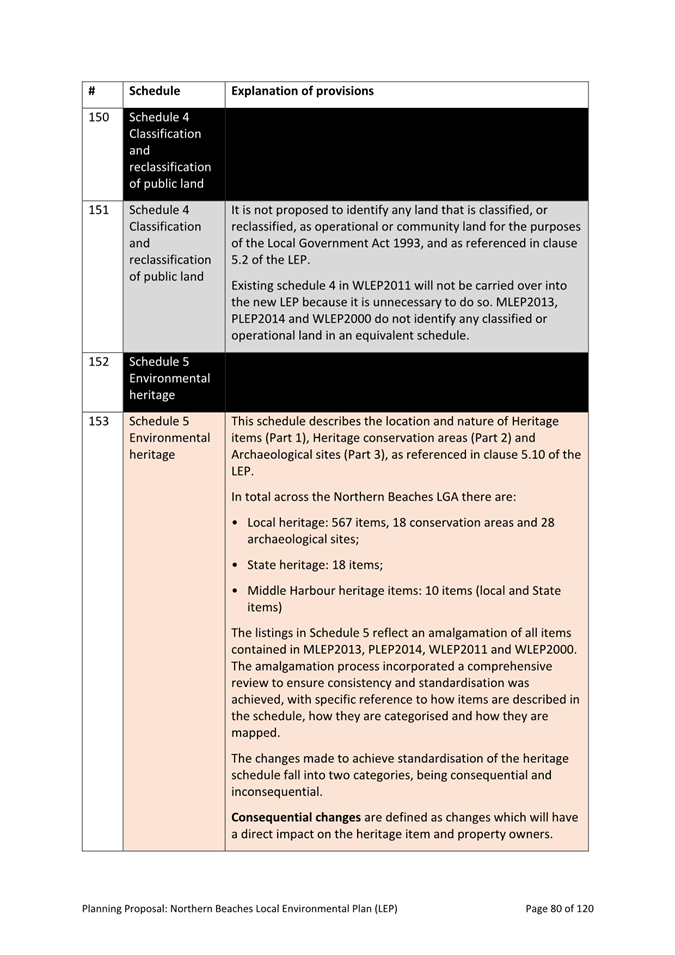
1. Retain existing conservation zoning throughout the LGA; and
2. Remove natural hazard criteria (e.g. bushfire prone or flood prone land) and “Medium Environmental Value” criteria from the zoning methodology.
- Following the Department’s final advice, Council amended its Conservation Zones criteria and methodology and prepared new mapping in accordance with those criteria.
- The revised methodology has resulted in changes to the number of properties proposed to be rezoned to Conservation Zone as part of the Conservation Zones Review.
- This has resolved many of the disputed rezonings. Independent reviews, potentially including site visits, will continue to be undertaken as required for any remaining disputed rezonings, or for any new disputed rezonings arising from the public exhibition of the LEP Planning Proposal.
![]()
· The Planning Proposal has been drafted and structured in accordance with the required Standard LEP Template.
· Council undertook early and targeted engagement on these and other key aspects of the Planning Proposal during this time. The objectives were to provide an understanding of the LEP overall; explain key proposed provisions and changes; and gain feedback on the identified key clauses that were considered of particular interest and importance to Councillors, the community and for purposes of protecting local character and the natural environment.
· Reporting this matter to the Northern Beaches Local Planning Panel (NBLPP) is a statutory requirement and the Panel’s advice is provided in the minutes from its formal meeting (see Attachment 2 as well as extract in the section below).
COMMUNITY CONSULTATION
The Planning Proposal is informed by extensive community and stakeholder consultation under the Planning our Sustainable Future program of land use planning works, starting with the statutory exhibition of the Local Strategic Planning Statement (LSPS) in 2020 and followed by the Local Housing Strategy in 2021. The results from these statutory public exhibitions have been reviewed and included in the development of the Planning Proposal.
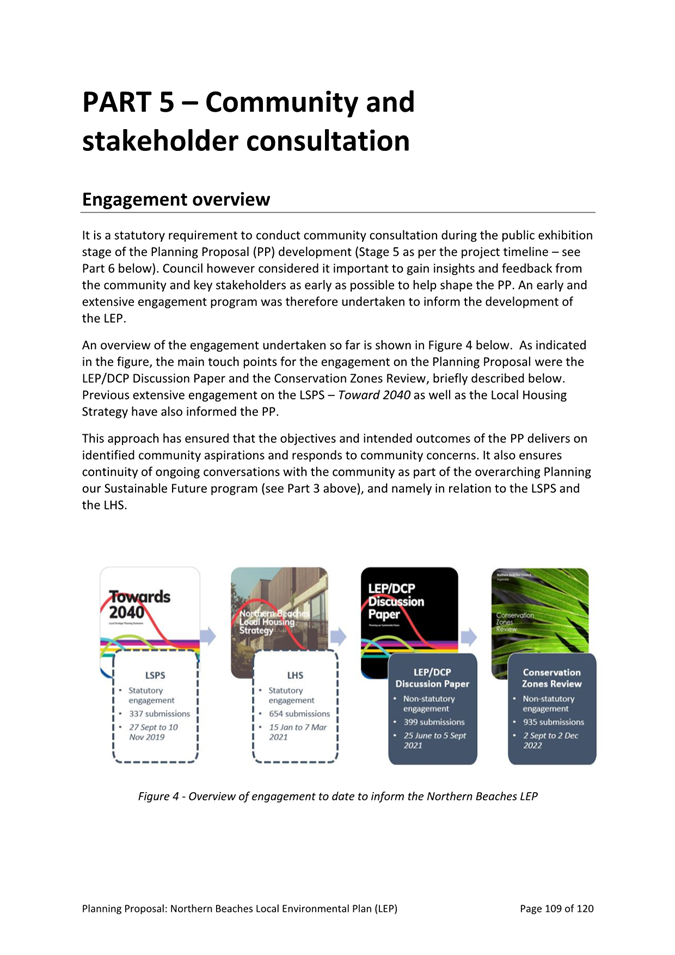
The project-specific engagement that directly has informed the Planning Proposal included the LEP/DCP Discussion Paper and the Conservation Zones Review (highlighted in Figure 4 and briefly summarised below). In total more than 2,300 people have contributed to the project.
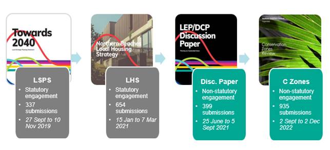
Figure 4 - overview of community consultation
Engagement to Inform Planning Proposal
LEP/DCP Discussion Paper – public exhibition
The overall purpose of the engagement was to seek early input from the community on identified issues and opportunities as well as potential approaches for addressing key priorities under the LSPS and Local Housing Strategy.
|
Component
|
Description |
|
Key objectives |
· Provide accessible information so community and stakeholders can participate in the LEP/DCP making process in a meaningful way. · Communicate to community and stakeholders how their input will continue to be incorporated into the planning and decision-making process. · Identify community concerns, local knowledge, and values. |
|
Materials and resources |
· LEP/DCP Discussion Paper – a comprehensive report that outlines key issues and opportunities relating to the four LSPS themes: Sustainability; Infrastructure and collaboration; Livability and Productivity. · Webinar to explain the discussion paper purpose and proposals. · FAQs - an overview of what's proposed. · Property search map - for property specific zoning and planning information. |
|
Method |
· Online survey via Council’s “Have Your Say” page · Social media posts · Electronic direct mail: - 5 updates in community newsletter (20,000 subscribers) - 6 Council news (150,000 subscribers) - 5 stakeholder updates (distribution 1,955) |
|
Key findings |
· Shared desire to protect the unique environment of Northern Beaches - our highly valued natural waterways, landscapes, and biodiversity. · Strong support for planning provisions to support tree canopy retention and protection. · Keen interest in the development of Local Character Statements that will be reflective of community values and the inherent and unique qualities of the LGA[1]. · Community overall support for a centre-based approach to housing provision – “housing in the right locations” – though many residents expressed a general concern about housing growth, noting this would create pressures on infrastructure, the environment and community services. · Strong interest in environmental sustainability, with comments urging Council to become a leader in this field and reduce the environmental footprint of buildings. · There were strong – but mixed – views regarding Deferred Lands (Belrose North and Oxford Falls Valley) zoning. Many residents expressed deep concern with future zoning and permissible uses for their properties. Broader community views emphasised the significant environmental values and important ecological and vegetation communities located in the area and called for stronger environmental protection and conservation zoning throughout Deferred Lands. |
Conservation Zones Review
The overall purpose of the engagement was to seek early input on the initial draft conservation zone methodology and related zonings (Conservation, Residential, Recreation, and Rural).[2]
|
Component
|
Description |
|
Key objectives |
· Gain feedback on the draft methodology and criteria for C zones. · Understand community sentiments toward proposed land uses. · Identify any mapping accuracy issues relating to technical studies and understand ground-truthing/site visit requirements. · Identify community values and aspirations for future land use and strategic planning. |
|
Materials and resources |
· Conservation Zones Review Report – a comprehensive report outlining the core definitions, assessment criteria, methodology, permitted land uses, mapping and community insights from previous engagement. · Seven supporting technical studies, including bushfire and biodiversity assessments for Deferred Lands; biodiversity planning review for the LGA; two estuary planning studies for Cowan Creek and North and Middle Harbour respectively; watercourse, wetlands, and riparian lands study; stormwater study; and a geotechnical review. · Interactive spatial mapping tool – providing detailed information on existing and proposed land use zoning, hazards, and environmental values across the LGA. The tool provided a landscape view of proposed zoning and mapping across the whole LGA, allowing users a to drill down to gain information at individual property scale about proposed methodology and land use changes for any property in the LGA. · Supporting materials – including explanatory project information, project updates and emails, overview video, Easy Read document summary, and project fact sheets and FAQs. |
|
Method |
· Letters to over 17,000 properties that were either currently in a conservation zone, proposed to be within a conservation zone, or proposed for removal from a conservation zone. The mailout also included all properties in the Deferred Lands LEP area. · Review and consolidate previous community feedback received during public exhibition on local strategic documents (namely LSPS and Local Housing Strategy). · Five online community focus group sessions held in early October 2020 to understand local issues and experiences and identify the important environmental values; and · A community survey which sought feedback on potential future land uses and environmental values. |
Table 2 – Summary of engagement for the LEP/DCP Discussion Paper
Key findings – community submissions on Conservation Zones Review
|
|
Community members 935 total unique responses and including from major landholders such as Metropolitan Aboriginal Land Council, schools, retirement villages were received. The top 10 themes are listed below, with % indicating how often the issue was raised out of all submissions: · Environment/ecology (32%) · Limiting existing uses concerns (24%) · Accuracy of mapping (23%) · Character of place (17%) · Tree canopy/biodiversity corridor support (16%) · Consistency in application of zoning concerns (13%) · Adequacy of mapping methodology – e.g. biodiversity (12%) · Secondary dwellings support (11%) · Bushfire concerns (11%)[3]
|
|
|
Community petitions · Pittwater Conservation Zones need to Stay (709 signatories) – objections to residential zoning of existing C4 land; support for conservation zoning on land with high environmental values or natural hazards present; call for scenic foreshore protection areas from shorelines to ridgelines; retain all heritage conservation areas and investigate further heritage protections. · Ebor Street residents - Palm Beach (11 signatories) – objecting to proposed zoning to residential (from C4) on grounds of high bushfire risk. · Rignold Street, Seaforth (18 signatories) – call for protection of biodiversity and environmental values, including application of C2 zoning and riparian zones protection. |
|
|
Community stakeholder groups 25 resident and ‘friends of’ place-based group submissions: · 15 submissions from place-based community groups in Pittwater (11 of which expressing specific concerns with proposed changes from C Zones to Residential; and 4 commenting on methodology). · 4 submissions from place-based community groups in Warringah (mainly expressing views on zoning of natural recreation areas, wanting to see C2 zoning while allowing sustainable recreational use namely for Manly Dam, Stony Range Regional Botanic Garden, Narrabeen Lagoon State Park, and Oxford Falls Regional Crown Reserve). · 3 submissions from place-based community groups in Manly (calling for C2 zoning while allowing sustainable recreational use in North Balgowlah, Manly Lagoon, and Curl Curl Lagoon). · 3 submissions from place-based community groups in Deferred Lands (one from Belrose Rural Community Association calling for tighter conservation zoning (e.g. C2 instead of C3) to conserve ecological values; and two from Warringah Urban Fringe Association and Bayview Ingleside Residents Association, both objecting to conservation zones in Deferred Lands and Metropolitan Rural Areas. · 5 Community interest groups (theme based) – key interests included tree canopy, environmental values, heritage (Aboriginal and non-Aboriginal) and concerns with development. |
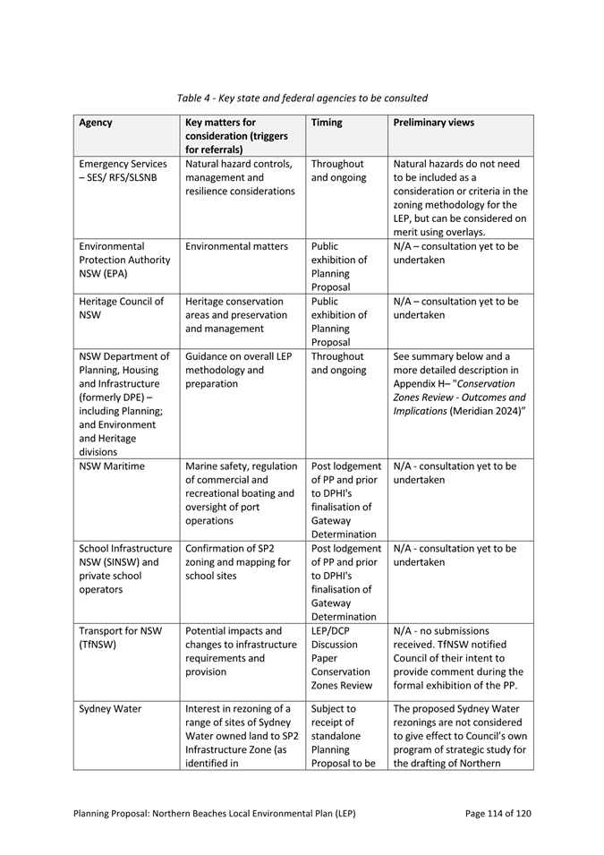
STAKEHOLDER CONSULTATION
Government agencies and key internal and external stakeholders were kept informed of the project progress throughout the process.
Specific stakeholder engagement activities on the Planning Proposal included (and were not limited to)[4]:
· Ongoing meetings with the Department and key stakeholders such as the Rural Fire Service throughout the project.
· 4 workshops/briefings for Councillors specifically on the LEP Planning Proposal development (in addition to briefings and Councillor meetings on the LEP/DCP Discussion Paper and the Conservation Zones Review).
· 2 workshops and one formal meeting of the Northern Beaches Planning Panel.
· 2 internal workshops for all planning staff to test key aspects of the Planning Proposal.
The stakeholder engagement on the Planning Proposal showed general appreciation and support for the need to consolidate the existing four LEPs into one. The stakeholder engagement also showed overall support for identified key clauses (see Discussion section above), with some input and suggestions provided (and subsequently incorporated) regarding key clauses of the Planning Proposal (including FSR, Landscaping, Dual Occupancy and Secondary Dwellings, and Housing Diversity clauses).
ADVICE FROM THE NORTHERN BEACHES LOCAL PLANNING PANEL
Proceedings in brief
The Planning Proposal was referred to the NBLPP meeting held on 23 May 2024 for advice in accordance with the Ministerial Direction for Local Planning Panels.
Prior to the meeting, the Panel received 4 submissions. The Panel also received written comments from the community representative Panel member who was unable to attend the meeting. The Panel considered all the above material in forming its view.
The full minutes of the NBLPP meeting are at Attachment 3.
Summary of NBLPP advice and Council response
“The Panel is of the view that the Planning Proposal is appropriate for submission to the Minister for Planning and Public Spaces for issue of a Gateway Determination, in accordance with the Ministerial Direction on referral criteria for Local Planning Panels: Local Planning Panels Direction – Planning Panels (August 2018).”
Amongst other matters, the Panel noted the complexity of the task of consolidating four LEPs and the thoroughness of Council’s approach, and that further dialogue will take place with the Department of Planning, Housing and Infrastructure prior to public exhibition. The Panel also noted the community consultation process that is planned to be undertaken following a Gateway determination.
Discussions with the Panel also identified some minor typographical and drafting errors to be corrected. These have been corrected in the Planning Proposal and Appendices that are attached to this report.
The Panel did not recommend any changes to the Planning Proposal but identified several matters it suggested should be further considered when drafting the LEP by the Department and Parliamentary Counsel (with reference to the indicative LEP at Appendix F to the Planning Proposal). The suggestions and Council’s responses are provided below.
a) Ensuring approaches to minimum lot size provisions for community title as well as strata subdivisions are consistent
Response: Noted. Existing clauses in Pittwater LEP 2014 and Warringah LEP 2011 relating to community and strata subdivision have been carried over into the new consolidated LEP. This matter will be further considered as part of the Gateway determination process by the Department of Planning.
b) Appropriate framing of objectives to retain clarity but which also provide an appropriate degree of flexibility
Response: Noted. Final drafting of LEP clauses takes place following exhibition of the Planning Proposal. A further review of the objectives of individual clauses will be undertaken at that time.
c) Grouping similar clauses, such as those related to attached and detached dual occupancies
Response: Noted. Final drafting of LEP clauses takes place following exhibition of the Planning Proposal. Grouping of clauses will be considered further at that time in consultation with the Department of Planning.
d) Defining the term “front building line”, and providing definitions of all new terms used where not in the Dictionary
Response: “Building Line” is a defined term in the Standard Instrument LEP. Consideration of whether further definition is required will take place at final drafting of the LEP following exhibition of the Planning Proposal.
e) Consideration of corner sites and lot width controls in relation to dual occupancies
Response: Noted. The proposed lot width control for dual occupancies (18 metres) is based on recommendations of the Urban Design Study commissioned by Council for the new LEP and DCP. It is proposed to permit detached dual occupancies on lots with dual street frontages (includes corner lots). The DCP will provide guidance in support of the LEP clause. Final drafting of LEP clauses takes place following exhibition of the Planning Proposal. This matter will be reviewed at that time having regard to submissions and advice from the Department of Planning.
f) Review of proposed content of the LEP and DCP to avoid conflict with equivalent provisions in the State Environmental Planning Policies (SEPPs)
Response: Noted. This will occur as part of the gateway determination process (LEP) in conjunction with the Department, and when developing Council’s DCP (to be separately reported to Council).
g) Review of LEP and DCP provisions to ensure that provisions are located within the most appropriate regulatory instrument, and to maximise complementarity
Response: Noted. This can be undertaken as part of the preparation of Council’s new DCP (to be separately reported to Council). The final determination regarding whether controls are in the new LEP or DCP will be determined by the Minister for Planning as part of the Gateway determination process and prior to making the new LEP.
h) Review of the wording of LEP development standards with an objective to reduce the number of Clause 4.6 variation requests where an alternative wording or approach will achieve the desired outcome
Response: Noted. Final drafting of LEP clauses takes place following exhibition of the Planning Proposal. This matter will be reviewed at that time having regard to submissions and advice from the Department of Planning.
i) Reconsideration of the necessity of the clause regarding noise impacts from licensed venues, including if any Special Entertainment Precincts are being considered
Response: Noted. This draft clause currently exists in MLEP 2013 and has been included in the Planning Proposal for a consolidated LEP for the purposes of public exhibition. Further consideration will be given to this clause together with any submissions that may be received as part of the exhibition process.
j) The Panel notes the potential amendments to Appendix I as outlined in the Supplementary Memo - 2024/374329
Response: Noted. The Supplementary Memo to the NBLPP suggested changes to Appendix I – Deferred Lands Background and Proposed Approach of the Planning Proposal in response to an LPP submission from the Warringah Urban Fringe Association. Minor amendments have been made to Appendix I to incorporate changes discussed with the Panel.
TIMING
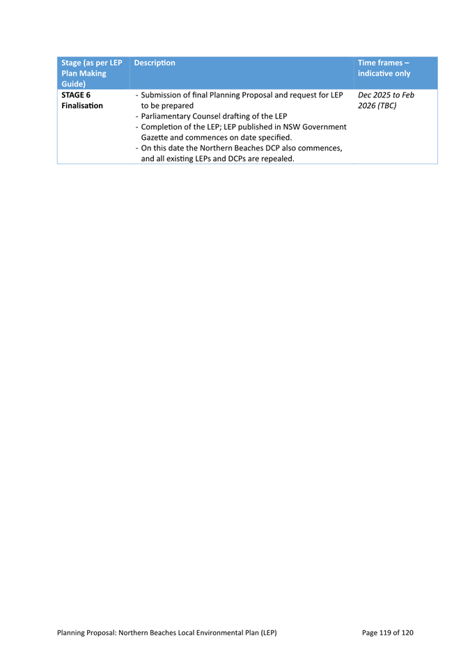
The next steps in terms of finalising the LEP are outlined below, as per the Department’s LEP Plan Making Guidelines (August 2023). See Part 6 of the Planning Proposal for further detail.
· Submit to Department of Planning for Gateway Determination, subject to Council endorsement (mid 2024).
· Gateway Determination issued by the Minister, including any conditions that must be met before public exhibition can take place (anticipated for end 2024).
· Finalise draft DCP and report to Council (end 2024/early 2025).
· Exhibit LEP Planning Proposal with draft DCP (early 2025, subject to timing of Gateway Determination and extent of any further work required to respond to conditions).
· Report back to Council for adoption (anticipated for mid 2025).
· Minister makes LEP (anticipated for second half 2025).
Financial Considerations
The recommendations in this report do not result in any change to the existing Council budget.
Governance and Risk Considerations
The Planning Proposal proposes changes to how land is zoned, used, and managed across the LGA. It is therefore critical that all Council interests in land is kept separate from the development of the LEP and that any potential conflicts of interest (whether on an individual or organisational level) is handled transparently and proactively.
To this end Council engaged an independent Probity Advisor who has assisted Council in developing a probity plan for the project. The plan sets out roles and responsibilities of all involved (including Councillors, CEO, Directors, Project Working Group, staff, and consultants). It also identifies probity risks and mitigation measures and establishes transparent procedures for managing risks.
These procedures and action include:
· Management of communication between Council’s Strategic and Place Planning unit (which is leading the development of the LEP) and the Property unit (which manages Council owned and managed land across the LGA).
· Confidentiality processes and actions to avoid improper access to confidential information within Council (e.g. such as restricting access to confidential files, appropriately maintaining records).
· Conflict of interest management to ensure that any actual, perceived, or potential interests are managed proactively and documented in a transparent manner throughout the project process.
Council has worked closely with the Probity Advisor to ensure compliance with the Probity Plan and a final audit of the LEP and DCP processes will be completed by the Probity Advisor prior to a Council resolution to adopt the final LEP and DCP.
Environmental Considerations
The proposed actions in this report will result in a beneficial environmental outcome by identifying environmental values throughout the LGA and establishing statutory protection of these values through application of Conservation zones. The Planning Proposal also proposes key provisions and clauses that will deliver positive environmental outcomes in both urban and bushland settings. These include (and are not limited to) key provisions such as for environmental sustainability of buildings; scenic protection; design excellence, landscaping and tree canopy clauses.
Social Considerations
The Planning Proposal will deliver significant positive social benefit by providing:
1. Greater clarity and certainty for land-use planning throughout the LGA, and especially for Deferred Lands.
2. A consistent and simpler set of planning rules that allows for greater transparency in the development application process, making it easier for homeowners to understand planning rules and make use of development potential of their properties.
3. Opportunities for greater housing diversity throughout the LGA and in a manner that is sensitive to local character (e.g. by controlling for bulk and scale through for example, FSR, building height controls). This especially relates to the proposed housing provisions such as a new clause for greater housing diversity, secondary dwellings to apply throughout the LGA, and permitting dual occupancy in all R2 zones subject to controls (e.g. minimum allotment size). This will particularly affect Warringah LEP area, as the WLEP2011 to date has not permitted dual occupancies in R2 zones.
4. Improved amenity and liveability outcomes for our centres, e.g. through protecting employment lands and controlling for building height in strategic centres.
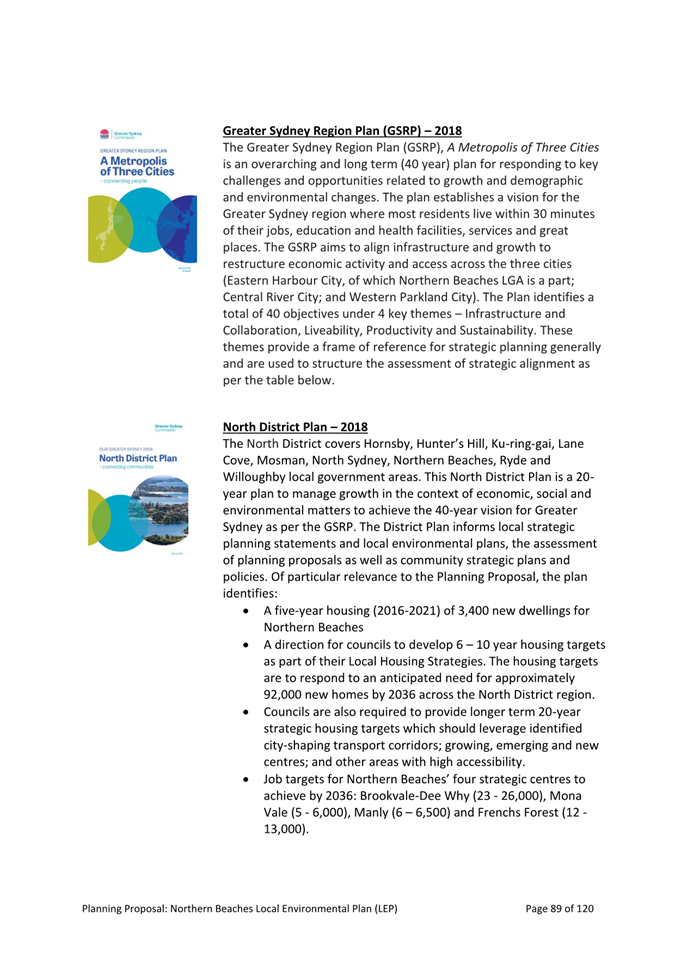
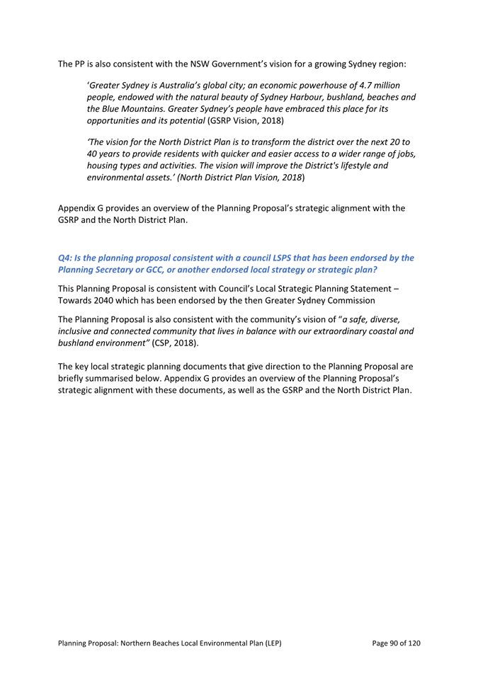
Link to Strategy
The Planning Proposal gives effect to a broad range of NSW Government objectives and actions. These include the overarching Greater Sydney Region Plan (GSPRP) A Metropolis of Three Cities – connecting people (2018) and the related North District Plan (2018). The Planning Proposal is also informed by a broad range of Council strategies namely the Community Strategic Plan – Shape 2028 (CSP); Local Strategic Planning Statement – Toward 2040 (LSPS), the Local Housing Strategy, and Northern Beaches Environment Study.
A brief outline of the key strategies that have shaped the Planning Proposal is provided below:
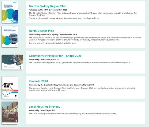
In addition to these guiding strategic documents, the Planning Proposal has been informed by a significant body of work and technical studies. Existing plans and studies of particular importance include (and are not limited to):
· Economic Development Strategy - Business on the Beaches
· Better Together Social Sustainability Strategy 2040
· Protect. Create. Live. Environment and Climate Change Strategy
· Climate Change Action Plan
· Bushland and Biodiversity Action Plan
· Environmental Education and Sustainable Living Action Plan
· Coast Action Plan
· Waterways and Catchments Action Plan
· Employment Study
· Draft Local Character Study
|
Reporting team |
Strategic & Place Planning |
|
TRIM file ref |
2024/327146 |
|
Attachments |
⇩1 Northern Beaches LEP Planning Proposal ⇩2 Appendices Index and Links - Northern Beaches Planning Proposal ⇩3 Minutes - Northern Beaches Local Planning Panel - Extraordinary Meeting 23 May 2024 |